Dickson, Tennessee | |
---|---|
Coordinates: 36°4′17″N87°22′28″W / 36.07139°N 87.37444°W | |
Country | United States |
State | Tennessee |
County | Dickson |
Government | |
• Mayor | Don L. Weiss Jr. |
• Chief of Police | Jeff Lewis |
Area | |
• Total | 20.41 sq mi (52.85 km2) |
• Land | 20.32 sq mi (52.64 km2) |
• Water | 0.08 sq mi (0.21 km2) |
Elevation | 804 ft (245 m) |
Population | |
• Total | 16,058 |
• Density | 790.10/sq mi (305.06/km2) |
Time zone | UTC-6 (Central (CST)) |
• Summer (DST) | UTC-5 (CDT) |
ZIP codes | 37055-37056 |
Area code | 615 |
FIPS code | 47-20620 [3] |
GNIS feature ID | 1303436 [4] |
Website | www |
Dickson is a city in the U.S. state of Tennessee. Located in Dickson County. It is part of the Nashville metropolitan area. As of the 2020 census, Dickson's population was 16,058. [5]
Dickson was named for Congressman William Dickson, as was Dickson County. [6] The City started as a stop on the railroad line between Nashville and the Tennessee River. When Union Troops had finished the supply line during the Civil War, the area was known as Mile 42 post. [7]
It is disputed on what the community was known as prior to being named Dickson. [7] Dr. Robert Corlew's book A History of Dickson County makes the claim that the community was named Sneedsville in honor of a railroad engineer named Sneed who helped complete the tracks under the orders of General Ulysses S. Grant. [8] Various other sources also state that the city was at one point named Sneedsville. [7] [9] [10] Other sources claim that the community was named Smeedsville rather than Sneedsville. One claim comes from a series of writings for the Dickson Free Press by former mayor Robert S. Clement From Mile Post 42… To City of Dickson 1980. In article 7 "Was it called Sneedsville or Smeedsville?" Clement writes about a 1867 Chancery Court decree that was brought to his attention by historian Henry Ragan that refers to the land as "Smeedsville, Dickson County, Tennessee.", and that Ragan interviewed various locals who remembered the town being named Smeedsville. [11] [7] Corlew claimed that he had found Chancery Court documents from the same year that incorporated the area as Sneedsville or Smeedsville, and that it's hard to interpret it being an "n" or an "m" due to the handwriting.
Dickson is located in south-central Dickson County at 36°4′17″N87°22′28″W / 36.07139°N 87.37444°W (36.071485, -87.374539). [12] It is bordered to the east by the town of Burns. U.S. Route 70 passes through the north side of the city as Henslee Drive; it leads east 40 miles (64 km) to Nashville and west 62 miles (100 km) to Huntingdon. Interstate 40 passes through the Dickson city limits 5 miles (8 km) south of the center of town, with access from Exit 172 (Tennessee State Route 46). I-40 leads east 37 miles (60 km) to Nashville from Exit 172 and west 92 miles (148 km) to Jackson.
According to the United States Census Bureau, Dickson has a total area of 20.0 square miles (51.9 km2), of which 20.0 square miles (51.7 km2) is land and 0.1 square miles (0.2 km2), or 0.41%, is water. The city center sits on the Tennessee Valley Divide, with the southwest side of the city draining via the East Piney River to the Piney River, then to the Duck River, and then to the Tennessee River, while the northeast side drains via Turnbull Creek or Jones Creek to the Harpeth River and thence to the Cumberland River.
Climate data for Dickson, Tennessee (1991–2020 normals, extremes 1900–present) | |||||||||||||
---|---|---|---|---|---|---|---|---|---|---|---|---|---|
Month | Jan | Feb | Mar | Apr | May | Jun | Jul | Aug | Sep | Oct | Nov | Dec | Year |
Record high °F (°C) | 80 (27) | 82 (28) | 93 (34) | 95 (35) | 98 (37) | 109 (43) | 110 (43) | 110 (43) | 108 (42) | 95 (35) | 88 (31) | 78 (26) | 110 (43) |
Mean daily maximum °F (°C) | 47.5 (8.6) | 52.3 (11.3) | 61.1 (16.2) | 70.9 (21.6) | 77.4 (25.2) | 84.1 (28.9) | 86.9 (30.5) | 86.9 (30.5) | 81.3 (27.4) | 71.0 (21.7) | 59.5 (15.3) | 50.4 (10.2) | 69.1 (20.6) |
Daily mean °F (°C) | 37.5 (3.1) | 41.4 (5.2) | 49.4 (9.7) | 58.6 (14.8) | 66.1 (18.9) | 73.5 (23.1) | 76.9 (24.9) | 76.1 (24.5) | 69.9 (21.1) | 59.0 (15.0) | 48.0 (8.9) | 40.5 (4.7) | 58.1 (14.5) |
Mean daily minimum °F (°C) | 27.5 (−2.5) | 30.4 (−0.9) | 37.7 (3.2) | 46.2 (7.9) | 54.9 (12.7) | 62.9 (17.2) | 66.8 (19.3) | 65.4 (18.6) | 58.5 (14.7) | 46.9 (8.3) | 36.5 (2.5) | 30.6 (−0.8) | 47.0 (8.3) |
Record low °F (°C) | −23 (−31) | −14 (−26) | −1 (−18) | 16 (−9) | 29 (−2) | 38 (3) | 48 (9) | 42 (6) | 32 (0) | 20 (−7) | −3 (−19) | −13 (−25) | −23 (−31) |
Average precipitation inches (mm) | 4.33 (110) | 4.90 (124) | 5.44 (138) | 4.93 (125) | 5.79 (147) | 4.02 (102) | 4.62 (117) | 3.45 (88) | 3.45 (88) | 4.04 (103) | 3.97 (101) | 5.13 (130) | 54.07 (1,373) |
Average snowfall inches (cm) | 0.8 (2.0) | 0.6 (1.5) | 0.5 (1.3) | 0.0 (0.0) | 0.0 (0.0) | 0.0 (0.0) | 0.0 (0.0) | 0.0 (0.0) | 0.0 (0.0) | 0.0 (0.0) | 0.0 (0.0) | 0.6 (1.5) | 2.5 (6.4) |
Average precipitation days (≥ 0.01 in) | 10.3 | 9.9 | 10.4 | 10.2 | 10.2 | 9.6 | 9.3 | 8.0 | 6.7 | 7.9 | 8.9 | 10.5 | 111.9 |
Average snowy days (≥ 0.1 in) | 0.4 | 0.4 | 0.3 | 0.0 | 0.0 | 0.0 | 0.0 | 0.0 | 0.0 | 0.0 | 0.0 | 0.4 | 1.5 |
Source: NOAA [13] [14] |
Census | Pop. | Note | %± |
---|---|---|---|
1890 | 938 | — | |
1900 | 1,363 | 45.3% | |
1910 | 1,850 | 35.7% | |
1920 | 2,263 | 22.3% | |
1930 | 2,902 | 28.2% | |
1940 | 3,504 | 20.7% | |
1950 | 3,348 | −4.5% | |
1960 | 5,028 | 50.2% | |
1970 | 5,665 | 12.7% | |
1980 | 7,040 | 24.3% | |
1990 | 8,791 | 24.9% | |
2000 | 12,244 | 39.3% | |
2010 | 14,538 | 18.7% | |
2020 | 16,058 | 10.5% | |
Sources: [15] [16] [2] |
Race | Number | Percentage |
---|---|---|
White (non-Hispanic) | 12,464 | 77.62% |
Black or African American (non-Hispanic) | 1,224 | 7.62% |
Native American | 57 | 0.35% |
Asian | 170 | 1.06% |
Other/Mixed | 866 | 5.39% |
Hispanic or Latino | 1,277 | 7.95% |
As of the 2020 United States census, there were 16,058 people, 5,842 households, and 3,690 families residing in the city.
As of the census of 2000, there were 12,244 people, 4,934 households, and 3,300 families residing in the city. [3] There were 24,325 people in the 37055 zip code. The population density was 743.4 inhabitants per square mile (287.0/km2). There were 5,280 housing units at an average density of 320.6 per square mile (123.8/km2). The racial makeup of the city was 87.86% White, 8.83% African American, 0.46% Native American, 0.56% Asian, 0.77% from other races, and 1.54% from two or more races. Hispanic or Latino of any race were 1.94% of the population.
There were 4,934 households, out of which 34.2% had children under the age of 18 living with them, 46.5% were married couples living together, 16.8% had a female householder with no husband present, and 33.1% were non-families. 29.1% of all households were made up of individuals, and 11.6% had someone living alone who was 65 years of age or older. The average household size was 2.42 and the average family size was 2.97.
In the city the population was spread out, with 27.2% under the age of 18, 9.0% from 18 to 24, 28.9% from 25 to 44, 20.6% from 45 to 64, and 14.4% who were 65 years of age or older. The median age was 35 years. For every 100 females, there were 86.7 males. For every 100 females age 18 and over, there were 79.8 males.
The median income for a household in the city was $34,549, and the median income for a family was $42,632. Males had a median income of $32,733 versus $23,138 for females. The per capita income for the city was $17,654. About 12.6% of families and 15.3% of the population were below the poverty line, including 19.3% of those under age 18 and 14.2% of those age 65 or over.
The City of Dickson is governed by a mayor and City Council. Mayor Don Weiss, Jr., has served in office since 1993, making him the longest-serving mayor of Dickson. [18]
The City of Dickson is divided into four wards, each of which elects two members to the City Council. Councillors are elected to staggered four-year terms, with one councillor from each ward being elected every two years. [19]
As the Mayor of Dickson is only a part-time job, a City Administrator is also appointed to oversee the day-to-day operations of the city government and its budget. [20]
The City of Dickson Parks and Recreation Department maintains and operates various green spaces in Dickson, including sports areas, playgrounds, lake areas, and community centers. [21]
Robertson County is a county located on the central northern border of Tennessee in the United States. As of the 2020 United States Census, the population was 72,803 people. Its county seat is Springfield. The county was named for James Robertson, an explorer, founder of Nashville, and a state senator, who was often called the "Father of Middle Tennessee." Robertson County is a component of the Nashville-Davidson–Murfreesboro–Franklin, TN Metropolitan Statistical Area.
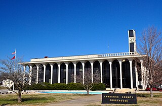
Lawrence County is a county located in the U.S. state of Tennessee. As of the 2020 census, the population was 44,159. Its county seat and largest city is Lawrenceburg. Lawrence County comprises the Lawrenceburg, TN Micropolitan Statistical Area, which is also included in the Nashville-Davidson-Murfreesboro, TN Combined Statistical Area.
Humphreys County is a county located in the western part of Middle Tennessee, in the U.S. state of Tennessee. As of the 2020 census, the population was 18,990. Its county seat is Waverly.
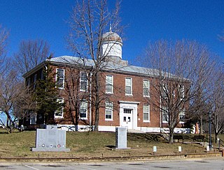
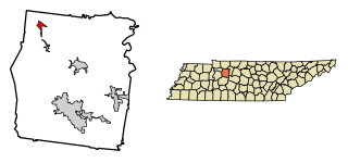
Dickson County is a county located in the U.S. state of Tennessee. As of the 2020 census, the population was 54,315. Its county seat is Charlotte. Dickson County is part of the Nashville-Davidson–Murfreesboro–Franklin, TN Metropolitan Statistical Area. Dickson County is home to Tennessee's oldest courthouse in continuous use, built in 1835. This is the second courthouse in Charlotte as the first one, a log building, was destroyed in the Tornado of 1833, which destroyed all but one building on the courthouse square.
Davidson County is a county in the U.S. state of Tennessee. It is located in the heart of Middle Tennessee. As of the 2020 census, the population was 715,884, making it the 2nd most populous county in Tennessee. Its county seat is Nashville, the state capital and most populous city.
Guthrie is a home rule-class city in Todd County, Kentucky, in the United States. The population was 1,330 at the 2020 census.
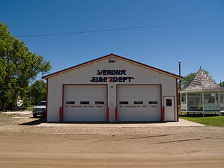
Verona is a city in LaMoure County, North Dakota, United States. The population was 59 at the 2020 census. Verona was founded in 1886.
Ashland City is a town and the county seat of Cheatham County, Tennessee. Located in Middle Tennessee, it is part of the Nashville-Davidson–Murfreesboro–Franklin, TN Metropolitan Statistical Area. As of the 2020 census, the town's population was 5,193.
Pleasant View is a city on the northern border of Cheatham County. Located in Middle Tennessee, it is part of the Nashville-Davidson–Murfreesboro–Franklin, TN Metropolitan Statistical Area. As of the 2020 census, the city's population was 4,807.
Manchester is a city in Coffee County, Tennessee, United States. The population was 12,213 at the 2020 census. It is the county seat of Coffee County. The city is located halfway between Nashville and Chattanooga on Interstate 24.
Burns is a town in Dickson County, Tennessee, in the United States. It is part of the Nashville-Davidson–Murfreesboro–Franklin, TN Metropolitan Statistical Area. The population was 1,468 at the 2010 census.
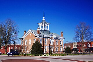
Charlotte is a town in Dickson County, Tennessee, United States. The population was 1,656 at the 2020 census. It is the county seat of Dickson County. This town is part of the Nashville metropolitan area.
Slayden is a town in Dickson County, Tennessee, United States. The population was 178 at the 2010 census.
Vanleer is a town in Dickson County, Tennessee, United States. The population was estimated to be 422 in 2019, up from 395 at the 2010 census. The town is approximately 49 miles northwest of Nashville and is located within the city's greater metropolitan area.
Centerville is a town in Hickman County, Tennessee, United States. The population was 3,489 as of the 2020 Census. It is the county seat and the only incorporated town in Hickman County. It is best known for being the hometown of American comedian Minnie Pearl.
Hohenwald is a city in and the county seat of Lewis County, Tennessee. The population was 3,757 at the 2010 census. The name "Hohenwald" derives from German meaning “High Forest".
Sunbright is a city in Morgan County, Tennessee, United States. The population was 519 at the 2020 census.
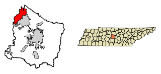
La Vergne is a city in Rutherford County, Tennessee, United States. The population was 38,719 at the 2020 census. La Vergne lies within the Nashville Metropolitan Statistical Area.
Cumberland City is a town in Stewart County, Tennessee. The population was 311 at the 2010 census. It is part of the Clarksville, TN — Kentucky Metropolitan Statistical Area.
Dover is a city in and the county seat of Stewart County, Tennessee, 67 miles (108 km) west-northwest of Nashville on the Cumberland River. Fort Donelson National Cemetery is in Dover. The population was 1,442 at the 2000 census and the 2010 census showed a population of 1,417.
Perhaps, with great skill and deference, his students could reach the coveted middle-class status that he had attained, owning a ranch in nearby Dickson in addition to his president's residence on campus, provided by the university.