
Jabalpur, formerly Jubbulpore, is a city situated on the banks of Narmada River in the state of Madhya Pradesh, India. It is the third-largest urban agglomeration of the state and the 38th-largest of the country. Jabalpur is the administrative headquarters of the Jabalpur district and the Jabalpur division. It is the judicial capital of Madhya Pradesh as the Madhya Pradesh High Court is located in the city. It is generally accepted that the game of snooker originated in Jabalpur. Jabalpur is also the railway headquarters of the West Central Railway. Jabalpur Cantonment is one of the largest cantonments in India and houses the army headquarters of five states. The city is known for the marble rocks on the river Narmada at Bhedaghat.
Anuppur is a City in northeastern Madhya Pradesh state of central India. It is the administrative headquarters of the Anuppur tehsil and Anuppur District. Previously, it was in Shahdol district
Mandla is a city with municipality in Mandla district in the Indian state of Madhya Pradesh. It is the administrative headquarters of Mandla District. The city is situated in a loop of the Narmada River, which surrounds it on three sides, and for 15 miles between Mandla and Ramnagar, Madhya Pradesh the river flows in a deep bed unbroken by rocks. The Narmada is worshiped here, and many ghats have been constructed on the banks of the river. It was a capital of the Gondwana Kingdom who built a palace and a fort, which in the absence of proper care have gone to ruins.

The Baiga are an ethnic group found in central India primarily in the state of Madhya Pradesh, and in smaller numbers in the surrounding states of Uttar Pradesh, Chhattisgarh and Jharkhand. The largest number of Baiga is found in Baiga-chuk in Mandla district and Balaghat district of Madhya Pradesh. They have sub-castes: Bijhwar, Narotia, Bharotiya, Nahar, Rai maina and Kath maina. The name Baiga means "sorcerer-medicine man".

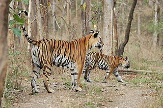
Rewa district is a district of the Madhya Pradesh state in central India. The city of Rewa is the district headquarter. Rewa is sometimes called the "Land of White Tigers", as the first White Tiger was discovered here in 1951 by the Maharaja of the province, Martand Singh, in the nearby jungle of Govindgarh. Rewa was the capital city of a former state, Vindhya Pradesh.

Shahdol District is a district of Madhya Pradesh state in east central India. It old name was Matsya raj or Virat kingdom in the name of great king Maharaja Virata. With a total area of 6,205 km2 (2,396 sq mi) and a population of 10,66,063. Shahdol is an important district of Madhya Pradesh. The town of Shahdol is the district headquarters. The district formerly comprised Shahdol division.
Umaria district is a district of Madhya Pradesh. The town of Umaria is the district headquarters. The district is part of Shahdol Division.

Balaghat district is a district of Madhya Pradesh state in Central India. Its belongs to Jabalpur Division. Balaghat city is Administrative Headquarter of Balaghat District.

Dindori District, formerly known as Ramgarh District, is a district of Madhya Pradesh state of central India. The town of Dindori is the district headquarters. The district is part of Jabalpur Division. Total area of the district is 6,128 km2 (2,366 sq mi). It is located on the eastern part of Madhya Pradesh, bordering the state of Chhattisgarh. It is surrounded by Anuppur district to the northeast, Umaria district to the north, Jabalpur district to the west, Mandla district to the southwest and Mungeli and Kabirdham districts of Chhattisgarh to the south.

Mandla District is a district of Madhya Pradesh in central India. The town of Mandla is the administrative headquarters of the district. It is part of Jabalpur Division.

Anuppur District (अनूपपुर) is an administrative district in Shahdol Division of Madhya Pradesh state in central India.
Chhuikhadan is a city municipality and district in Khairagarh-Chhuikhadan-Gandai district in the Indian state of Chhattisgarh, India. Chhuikhadan is also known as "City of Martyrs".
Nowrozabad or Khodargama is a city and a Nagar Palika in Umaria district in the Indian state of Madhya Pradesh. Kendriya Vidyalaya Nowrozabad is situated in the G.M Complex Johilla area. Nowrozabad is the head office of Johilla area. The nearest Airport is at Jabalpur in Madhya pradesh. Nowrozabad Railway Station is on the Katni - Anuppur rail route. There are many coal mines around here. National Highway 43 has its route through Nowrozabad.

Maharani Avantibai Lodhi was an Indian Rajput queen-ruler and freedom fighter. She was the queen of the Ramgarh in Madhya Pradesh. An opponent of the British East India Company during the Indian Rebellion of 1857, information concerning her is sparse and mostly comes from folklore. In 21st century, she has been used as a political icon Thakurs.
Kabirdham district is one of the 33 administrative districts of Chhattisgarh state in central India. The district was earlier known as Kawardha district. The district is located between 21.32' to 22.28' north latitude and 80.48' to 81.48' east longitude. The district covers an area of 4,447.5 km2 (1,717.2 sq mi). The city of Kawardha is its administrative headquarters. This district is known for the Bhoramdeo temple located at a distance of 18 km from the district headquarters, Kawardha.

There are 43 recognized Scheduled Tribes in Madhya Pradesh, India, three of which have been identified as "Particularly Vulnerable Tribal Groups" or "PTGs". The population of Scheduled Tribals (ST) is 21.1 per cent of the state population, according to the 2011 census. Bounded by the Narmada River to the north and the Godavari River to the southeast, tribal peoples occupy the slopes of the region's mountains.

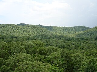
The Maikal Hills are range of hills in the state of eastern Madhya Pradesh and Chhattisgarh India. The Maikal Hills are an eastern part of the Satpuras in Kawardha District of Chhattisgarh and Anuppur district of Madhya Pradesh, overlooking the scenic town of Kawardha. Their altitudes range from 340 m to 942 m above sea level. This densely forested and thinly populated range gives rise to several streams and rivers including the tributaries of Narmada and Wainganga rivers. The hills are inhabited by two tribal peoples, the Baigas and the Gonds. The hill range is rich in flora and fauna wealth.

The 12853 / 12854 Amarkantak Express is a daily Superfast Express train which runs between the Bhopal Junction railway station in Bhopal, the capital city of Madhya Pradesh and Durg, a city in Chhattisgarh state in central India. This train replaced the 8225/8226 Bhopal–Bilaspur Mahanadi Express along with the 8291/8292 Bhopal–Raipur Express and the 1235/1236 Bhopal–Jabalpur Express.
Bilaspur is a village in Umaria district, Madhya Pradesh, India. Bilaspur is covered under Anuppur Assembly constituency at state level and Shahdol parliamentary constituency at national level. Bilaspur village is a gram panchayat as per the 2011 Census of India. The village has 250 houses with a population of 1,118 members consisting of 561 males and 557 females. Male literacy is 57.4% and female literacy is 40.04% making an average of 48.75%. Bilaspur is headed by a sarpanch who is elected through local elections.

Vivek Krishna Tankha is an Indian lawyer and politician, serving as a Senior Advocate at the Supreme Court of India and as a Member of Parliament. He previously had served as the Additional Solicitor General of India and Advocate General of Madhya Pradesh.

