
An airport is an aerodrome with extended facilities, mostly for commercial air transport. Airports usually consist of a landing area, which comprises an aerially accessible open space including at least one operationally active surface such as a runway for a plane to take off and to land or a helipad, and often includes adjacent utility buildings such as control towers, hangars and terminals, to maintain and monitor aircraft. Larger airports may have airport aprons, taxiway bridges, air traffic control centres, passenger facilities such as restaurants and lounges, and emergency services. In some countries, the US in particular, airports also typically have one or more fixed-base operators, serving general aviation.

Indira Gandhi International Airport is the primary international airport serving Delhi, the capital of India, and the National Capital Region (NCR). The airport, spread over an area of 5,106 acres (2,066 ha), is situated in Palam, Delhi, 15 km (9.3 mi) southwest of the New Delhi Railway Station and 16 km (9.9 mi) from New Delhi city centre. Named after Indira Gandhi (1917–1984), the former Prime Minister of India, it is the busiest airport of India in terms of passenger traffic since 2009. It is also the busiest airport in the country in terms of cargo traffic. In the financial year of 2020, the airport handled 6.73 crore passengers, the highest ever in the airport's history. As of 2022, it is the seventh busiest airport in the world, as per the latest rankings issued by the UK-based air consultancy firm, OAG. It is the second busiest airport in the world by seating capacity, having a seating capacity of over 36 lakh seats, and the busiest airport in Asia by passenger traffic, handling over 3.7 crore passengers in 2021.

According to the International Civil Aviation Organization (ICAO), a runway is a "defined rectangular area on a land aerodrome prepared for the landing and takeoff of aircraft". Runways may be a human-made surface or a natural surface. Runways, taxiways and ramps, are sometimes referred to as "tarmac", though very few runways are built using tarmac. Takeoff and landing areas defined on the surface of water for seaplanes are generally referred to as waterways. Runway lengths are now commonly given in meters worldwide, except in North America where feet are commonly used.

A short takeoff and landing (STOL) aircraft is a conventional fixed-wing aircraft that has short runway requirements for takeoff and landing. Many STOL-designed aircraft also feature various arrangements for use on airstrips with harsh conditions. STOL aircraft, including those used in scheduled passenger airline operations, have also been operated from STOLport airfields which feature short runways.

Kai Tak Airport(IATA: HKG, ICAO: VHHH) was an international airport of Hong Kong from 1925 until 1998. Officially known as Hong Kong International Airport from 1954 to 6 July 1998, it is often referred to as Hong Kong International Airport, Kai Tak, or simply Kai Tak and Kai Tak International Airport, to distinguish it from its successor, Chek Lap Kok International Airport, built on reclaimed and levelled land around the islands of Chek Lap Kok and Lam Chau, 30 kilometres (19 mi) to the west.

An airfield traffic pattern is a standard path followed by aircraft when taking off or landing while maintaining visual contact with the airfield.

A taxiway is a path for aircraft at an airport connecting runways with aprons, hangars, terminals and other facilities. They mostly have a hard surface such as asphalt or concrete, although smaller general aviation airports sometimes use gravel or grass.

Kozhikode International Airport also known as Calicut International Airport is an international airport serving the city of Malappuram and Kozhikode in the state of Kerala, India. It is located at Karipur near Kondotty in the Malappuram district of the South Malabar region. It serves the Malabar region, consisting of Malappuram, Wayanad and Palakkad. It is situated 28 km (17 mi) away from Kozhikode and 25 km (16 mi) away from Malappuram. It serves two of the seven metropolitan areas in the state—Kozhikode metropolitan area and Malappuram metropolitan area. The airport opened on 13 April 1988. The airport serves as an operating base for Air India Express and operates Hajj Pilgrimage services to Medina and Jeddah from Kerala. It is tied with Hyderabad in terms of international traffic. It received international airport status on 2 February 2006. It is one of the few airports in the country with a tabletop runway.

Pan Am Flight 845 was a Boeing 747-121, registration N747PA, operating as a scheduled international passenger flight between Los Angeles and Tokyo, with an intermediate stop at San Francisco International Airport.

Kalibo International Airport is an international airport that serves the general area of Kalibo, the capital of the province of Aklan in the Philippines, and is one of two airports serving Boracay, the other being Godofredo P. Ramos Airport in the municipality of Malay. It is the fastest growing airport in the Philippines in terms of passenger traffic with more than 50% growth in 2010, and 2nd fastest for seats offered for June 2014 over the corresponding month of the previous year (20%). The airport is classified as an international airport by the Civil Aviation Authority of the Philippines, a body of the Department of Transportation responsible for the operations of all airports in the Philippines except major international airports.
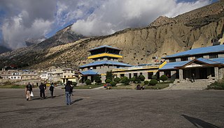
Jomsom Airport is a domestic airport located in Jomsom serving Mustang District, a district in Gandaki Province in Nepal. It serves as the gateway to Mustang District that includes Jomsom, Kagbeni, Tangbe, and Lo Manthang, and Muktinath temple, which is a popular pilgrimage for Nepalis and Indian pilgrims.

Jumla Airport is a domestic airport located in Jumla serving Jumla District, a district in Karnali Province in Nepal.

The Quincy Municipal Airport is a public-use airport located 2 miles (3.2 km) northeast of the central business district of the city of Quincy in Gadsden County, Florida, United States. The airport is publicly owned. The nearest airline service and jet fuel is 20 miles (32 km) away at Tallahassee International Airport (KTLH). The airport appears on the western edge of the Jacksonville VFR sectional. Taxi service is limited to none at all.

Mustique Airport is a private airfield owned by the Mustique Company for public use and is located on Mustique island, part of Saint Vincent and the Grenadines in the Caribbean Sea. It is used by civil aviation and national airlines using turboprop planes.
Northwest Regional Airport is a privately owned, public use airport 3 nautical miles (5.6 km) northwest of Roanoke, in Denton County, Texas, United States.
Paul C. Miller–Sparta Airport is a public airport located 3 mi (5 km) southeast of Sparta, Michigan. Established in 1941, the airport is currently owned and operated by the Village of Sparta and is self-supporting, requiring no public funding. It is included in the Federal Aviation Administration (FAA) National Plan of Integrated Airport Systems for 2017–2021, in which it is categorized as a regional general aviation facility.

Union Island Airport is the airport serving Union Island, Grenadines Parish, Saint Vincent and the Grenadines. It is located about 0.25 miles (0.40 km) from the town of Clifton, one of the country's main tourist centers and a major destination for charter leisure flights during the winter holiday season and Easter, for "Easterval" celebration. The airport serves as a focus city for flag carrier SVG Air and features flights to several short-haul regional destinations. It is the southmost airport of St. Vincent and the Grenadines.
Pokhara International Airport is an international airport in Pokhara, Gandaki Province, Nepal. It is located 3 km (1.9 mi) east of the old domestic airport, which it will gradually replace. The airport is Nepal's third international airport and officially began operations on 1 January 2023, with STOL-operations to Jomsom still being operated from the old airport. The airport is expected to handle up to one million passengers per year, but as of 2024 there has not been any regular international flights.

Miami Air International Flight 293 was a military charter from Guantanamo Bay to Naval Air Station Jacksonville, operated by Miami Air International. On May 3, 2019, the Boeing 737-800 aircraft operating the flight overran the runway on landing. Twenty-one people were injured. The aircraft was written off, making it the 17th loss of a Boeing 737-800. The National Transportation Safety Board (NTSB) attributed the accident to hydroplaning caused by heavy rainfall on the ungrooved runway; although the pilots were found to have made a series of errors during final approach and landing, the NTSB concluded that these errors had little effect on the final outcome, as the aircraft would have been unable to stop even if the landing had been executed properly.

On 23 December 1983, Korean Air Lines Flight 084 (KAL084), a McDonnell Douglas DC-10-30 performing a cargo flight, collided during its takeoff roll with SouthCentral Air Flight 59 (SCA59), a Piper PA-31-350, on runway 06L/24R at Anchorage International Airport, as a result of the KAL084 flight crew becoming disoriented while taxiing in dense fog and attempting to take off on the wrong runway. Both aircraft were destroyed, but no fatalities resulted.
