
Canada has a vast geography that occupies much of the continent of North America, sharing a land border with the contiguous United States to the south and the U.S. state of Alaska to the northwest. Canada stretches from the Atlantic Ocean in the east to the Pacific Ocean in the west; to the north lies the Arctic Ocean. Greenland is to the northeast with a shared border on Hans Island. To the southeast Canada shares a maritime boundary with France's overseas collectivity of Saint Pierre and Miquelon, the last vestige of New France. By total area, Canada is the second-largest country in the world, after Russia. By land area alone, however, Canada ranks fourth, the difference being due to it having the world's largest proportion of fresh water lakes. Of Canada's thirteen provinces and territories, only two are landlocked while the other eleven all directly border one of three oceans.

The Northwest Territories is a federal territory of Canada. At a land area of approximately 1,144,000 km2 (442,000 sq mi) and a 2016 census population of 41,790, it is the second-largest and the most populous of the three territories in Northern Canada. Its estimated population as of 2023 is 45,668. Yellowknife is the capital, most populous community, and only city in the territory; its population was 19,569 as of the 2016 census. It became the territorial capital in 1967, following recommendations by the Carrothers Commission.

Northern Canada, colloquially the North or the Territories, is the vast northernmost region of Canada variously defined by geography and politics. Politically, the term refers to the three territories of Canada: Yukon, Northwest Territories and Nunavut. This area covers about 48 per cent of Canada's total land area, but has less than 0.5 per cent of Canada's population.
Assiniboia District refers to two historical districts of Canada's Northwest Territories. The name is taken from the Assiniboine First Nation.
The vastness of Canada's Northwest Territories meant that for much of its history it was divided into several districts for ease of administration. The number and size of these territorial districts varied as other provinces and territories of Canada were created and expanded. The districts of the Northwest Territories were abolished in 1999 with the creation of the Nunavut territory and the contraction of the Northwest Territories to its current size.

The District of Saskatchewan was a regional administrative district of Canada's North-West Territories. It was formed in 1882 was later enlarged then abolished with the creation of the provinces of Saskatchewan and Alberta in 1905. Much of the area was incorporated into the province of Saskatchewan. The western part became part of Alberta, and the eastern part is now part of Manitoba.
Canadian Senate divisions refers to two aspects of the Senate of Canada. First, it refers to the division of Canada into four regional Senate divisions of 24 senators each, as set out in section 22 of the Constitution Act, 1867. The four regions are the Western Provinces, Ontario, Quebec and the Maritimes. These regions are intended to serve the Senate's purpose of providing regional representation in the Parliament of Canada, in contrast to the popular representation that the House of Commons is intended to provide. While not within any of the original four Senate divisions, Senate seats are also allocated to Newfoundland and Labrador and the three territories. The four divisions can be expanded when the need arises to have an extra two senators appointed to each regional division.

The history of Northwest Territories capital cities begins with the purchase of the Territories by Canada from the Hudson's Bay Company in 1869, and includes a varied and often difficult evolution. Northwest Territories is unique amongst the other provinces and territories of Canada in that it has had seven capital cities in its history. The territory has changed the seat of government for numerous reasons, including civil conflict, development of infrastructure, and a history of significant revisions to its territorial boundaries.

The District of Alberta was one of four districts of the Northwest Territories created in 1882. It was styled the Alberta Provisional District to distinguish it from the District of Keewatin which had a more autonomous relationship from the NWT administration. Present-day Province of Alberta takes in the District of Alberta and parts of the Districts of Athabasca, Assiniboia and Saskatchewan. Alberta became a province in 1905.
The Ecclesiastical Province of Rupert's Land, founded in 1875, forms one of four ecclesiastical provinces in the Anglican Church of Canada.

The history of the Northwest Territories covers the period from thousands of years ago to the present day. Prior to European colonization, the lands that encompass present-day Northwest Territories were inhabited for millennia by several First Nations. European explorers and fur traders began to explore the region since the late-16th century. By the 17th century, the British laid claim to both the North-Western Territory and Rupert's Land; and granted the Hudson's Bay Company a commercial fur trade monopoly over the latter region.

The history of post-confederation Canada began on July 1, 1867, when the British North American colonies of Canada, New Brunswick, and Nova Scotia were united to form a single Dominion within the British Empire. Upon Confederation, the United Province of Canada was immediately split into the provinces of Ontario and Quebec. The colonies of Prince Edward Island and British Columbia joined shortly after, and Canada acquired the vast expanse of the continent controlled by the Hudson's Bay Company, which was eventually divided into new territories and provinces. Canada evolved into a fully sovereign state by 1982.

The geography of Saskatchewan is unique among the provinces and territories of Canada in some respects. It is one of only two landlocked regions and it is the only region whose borders are not based on natural features like lakes, rivers, or drainage divides. The borders of Saskatchewan, which make it very nearly a trapezoid, were determined in 1905 when it became a Canadian province. Saskatchewan has a total area of 651,036 square kilometres (251,366 sq mi) of which 591,670 km2 (228,450 sq mi) is land and 59,366 km2 (22,921 sq mi) is water.

The Northwest Territories is a territory in Northern Canada, specifically in Northwestern Canada between Yukon Territory and Nunavut including part of Victoria Island, Melville Island, and other islands on the western Arctic Archipelago. Originally a much wider territory enclosing most of central and northern Canada, the Northwest Territories was created in 1870 from the Hudson's Bay Company's holdings that were sold to Canada from 1869-1870. In addition, Alberta and Saskatchewan were formed from the territory in 1905. In 1999, it was divided again: the eastern portion became the new territory of Nunavut. Yellowknife stands as its largest city and capital. It has a population of 42,800 and has an area of 532,643 sq mi (1,379,540 km2). The current territory lies west of Nunavut, north of latitude 60° north, and east of Yukon.

The 1763 Treaty of Paris ended the major war known by Americans as the French and Indian War and by Canadians as the Seven Years' War / Guerre de Sept Ans, or by French-Canadians, La Guerre de la Conquête. It was signed by Great Britain, France and Spain, with Portugal in agreement. Preferring to keep Guadeloupe, France gave up Canada and all of its claims to territory east of the Mississippi River to Britain. With France out of North America this dramatically changed the European political scene on the continent.
The Elk Point Group is a stratigraphic unit of Early to Middle Devonian age in the Western Canada and Williston sedimentary basins. It underlies a large area that extends from the southern boundary of the Northwest Territories in Canada to North Dakota in the United States. It has been subdivided into numerous formations, number of which host major petroleum and natural gas reservoirs.
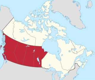
Western Canada, also referred to as the Western provinces, Canadian West or the Western provinces of Canada, and commonly known within Canada as the West, is a Canadian region that includes the four western provinces just north of the Canada–United States border namely British Columbia, Alberta, Saskatchewan and Manitoba. The people of the region are often referred to as "Western Canadians" or "Westerners", and though diverse from province to province are largely seen as being collectively distinct from other Canadians along cultural, linguistic, socioeconomic, geographic and political lines. They account for approximately 32% of Canada's total population.
The Cassiar Land District is a cadastral survey subdivision of the province of British Columbia, Canada, created with rest of those on Mainland British Columbia via the Lands Act of the Colony of British Columbia in 1860. The British Columbia government's BC Names system, a subdivision of GeoBC, defines a land district as "a territorial division with legally defined boundaries for administrative purposes". All land titles and surveys use the Land District system as the primary point of reference, and entries in BC Names for placenames and geographical objects are so listed.


