The country of Norway is historically divided into a number of districts. Many districts have deep historical roots, and only partially coincide with today's administrative units of counties and municipalities. The districts are defined by geographical features, often valleys, mountain ranges, fjords, plains, or coastlines, or combinations of the above. Many such regions were petty kingdoms up to the early Viking Age.
Southern Norway's districts during the Middle AgesNorthern Norway's districts during the Middle Ages
A high percentage of Norwegians identify themselves more by the district they live in or come from, than the formal administrative unit(s) whose jurisdiction they fall under[citation needed]. A significant reason for this is that the districts, through their strong geographical limits, have historically delineated the region(s) within which one could travel without too much trouble or expenditure of time and money (on foot or skis, by horse/ox-drawn cart or sleigh or dog sled, or by one's own small rowing or sail boat). Thus, dialects and regional commonality in folk culture tended to correspond to those same geographical units, despite any division into administrative districts by authorities.
In modern times the whole country has become more closely connected, based on the following:
Communication technologies such as telegraph, newspapers, telephone, radio and TV, in particular Televerket and NRK.
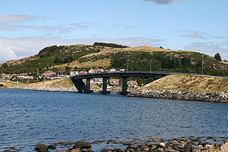
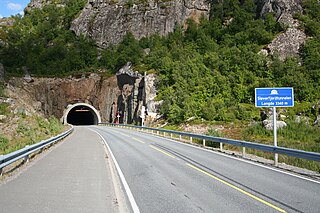
The construction of mountain crossings, tunnels through mountains, bridges, undersea tunnels; many of these projects, particularly the larger bridges and the undersea tunnels, were undertaken as late as the 1970s forward.
Establishing a coastal express route of combined passenger and cargo ships, like the Hurtigruten, sailing regularly from Bergen to Kirkenes and back again, and stopping by at a host of cities and towns along the western and northern coast.
The construction of railroads between distant parts of the country.
The opening of dozens of new airports all over the country through the 1960s and 1970s.
The release of private cars from government rationing and import restrictions from the 1950s onwards.
A concrete display of the Norwegian habit of identifying themselves by district can be seen in the many regional costumes, called bunad, strictly connected to distinct districts across the country. Commonly, even city dwellers proudly mark their rural origins by wearing such a costume, from their ancestral landscape, at weddings, visits with members of the royal family, Constitution Day (May 17), and other ceremonial occasions.
List of traditional districts
The following list is non-exhaustive and partially overlapping.
The first name is the name in Bokmål, the second Nynorsk.
Continental Europe or mainland Europe is the contiguous mainland of Europe, excluding its surrounding islands. It can also be referred to ambiguously as the European continent, – which can conversely mean the whole of Europe – and, by some, simply as the Continent. When Eurasia is regarded as a single continent, Europe is treated both as a continent and subcontinent.
In geography, regions, otherwise referred to as areas, zones, lands or territories, are portions of the Earth's surface that are broadly divided by physical characteristics, human impact characteristics, and the interaction of humanity and the environment. Geographic regions and sub-regions are mostly described by their imprecisely defined, and sometimes transitory boundaries, except in human geography, where jurisdiction areas such as national borders are defined in law. More confined or well bounded portions are called locations or places.
Rennesøy is a former municipality in Rogaland county, Norway. It was merged into Stavanger municipality on 1 January 2020. It was located in the traditional district of Ryfylke. The administrative centre of the municipality is the village of Vikevåg. Other villages in Rennesøy included Askje and Sørbø. The municipality encompassed a number of islands on the south side of the Boknafjorden, north of the city of Stavanger.
Valais, more formally the Canton of Valais, is one of the 26 cantons forming the Swiss Confederation. It is composed of thirteen districts and its capital and largest city is Sion. The flag of the canton is made of thirteen stars representing the districts, on a white-red background.
The regions of Greece are the country's thirteen first-level administrative entities, each comprising several second-level units, originally known as prefectures and, since 2011, as regional units.
Aetolia-Acarnania is one of the regional units of Greece. It is part of the geographic region of Central Greece and the administrative region of West Greece. A combination of the historical regions of Aetolia and Acarnania, it is the country's largest regional unit. Its capital is Missolonghi for historical reasons, with its biggest city and economic centre at Agrinio. The area is now connected with the Peloponnese peninsula via the Rio-Antirio Bridge. The surrounding regional units take in Arta in Epirus, a narrow length bordering Karditsa of Thessaly, Evrytania to the northeast, and Phocis to the east.
The traditional geographic regions of Greece are the country's main historical-geographic regions, and were also official administrative regional subdivisions of Greece until the 1987 administrative reform. Despite their replacement as first-level administrative units by only partly identical administrative regions, the nine traditional geographic regions—six on the mainland and three island groups—are still widely referred to in unofficial contexts and in daily discourse.
The Cumberland Gap Tunnel is a dual-bore, four lane vehicular tunnel that carries U.S. Route 25E under Cumberland Gap National Historical Park near the intersection of Kentucky, Tennessee, and Virginia. The tunnel consists of two separate bores which carry four lanes of traffic between Cumberland Gap, Tennessee and Middlesboro, Kentucky. It is one of only two mountain vehicular tunnels in the United States that cross a state line, the other being the East River Mountain Tunnel on Interstate 77 and U.S. Route 52 between Virginia and West Virginia. The tunnel opened to traffic in 1996 and replaced a section of highway through the Cumberland Gap that had earned the nickname "Massacre Mountain" due to its hazardous design and high rate of traffic accidents.
Lower Carniola is a traditional region in Slovenia, the southeastern part of the historical Carniola region.
The British Columbia Interior, popularly referred to as the BC Interior or simply the Interior, is a geographic region of the Canadian province of British Columbia. While the exact boundaries are variously defined, the British Columbia Interior is generally defined to include the 14 regional districts that do not have coastline along the Pacific Ocean or Salish Sea, and are not part of the Lower Mainland. Other boundaries may exclude parts of or even entire regional districts, or expand the definition to include the regional districts of Fraser Valley, Squamish–Lillooet, and Kitimat–Stikine.
An underwater tunnel is a tunnel which is partly or wholly constructed under the sea or a river. They are often used where building a bridge or operating a ferry link is unviable, or to provide competition or relief for existing bridges or ferry links. While short tunnels are often road tunnels which may admit motorized traffic, unmotorized traffic or both, concerns with ventilation lead to the longest tunnels being electrified rail tunnels.
The Eiksund tunnel is an undersea tunnel in Møre og Romsdal county, Norway, which runs under the Vartdalsfjorden connecting the municipalities of Ørsta and Ulstein. The tunnel is 7,765 metres (25,476 ft) long and reaches a depth of 287 metres (942 ft) below sea level, and was the deepest undersea tunnel in the world until Norway's Rogaland county opened its 292 m (958 ft) deep Ryfast tunnel system in December 2019.
Flakstadøya is an island in the Lofoten archipelago in Nordland county, Norway. The entire island lies within Flakstad Municipality with the Vestfjorden on the east side of the island and the Norwegian Sea on the west side of the island.
A fixed link or fixed crossing is a permanent, unbroken road or rail connection across water that uses some combination of bridges, tunnels, and causeways and does not involve intermittent connections such as drawbridges or ferries. A bridge–tunnel combination is commonly used for major fixed links.
Lofoten Mainland Connection or Lofast is a part of European route E10 that connects the Norwegian archipelago of Lofoten to the mainland, giving direct access to Lofoten from the surrounding municipalities.
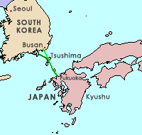
The Japan–Korea Undersea Tunnel, or Korea–Japan Undersea Tunnel, is a proposed tunnel project to connect Japan with South Korea via an undersea tunnel crossing the Korea Strait that would use the strait islands of Iki and Tsushima, a straight-line distance of approximately 128 kilometers (80 mi) at its shortest.
A tourism region is a geographical region that has been designated by a governmental organization or tourism bureau as having common cultural or environmental characteristics. These regions are often named after historical or current administrative and geographical regions. Others have names created specifically for tourism purposes. The names often evoke certain positive qualities of the area and suggest a coherent tourism experience to visitors. Countries, states, provinces, and other administrative regions are often carved up into tourism regions. In addition to drawing the attention of potential tourists, these tourism regions often provide tourists who are otherwise unfamiliar with an area with a manageable number of attractive options.
The following outline is provided as an overview of and topical guide to geography:
This page is based on this Wikipedia article Text is available under the CC BY-SA 4.0 license; additional terms may apply. Images, videos and audio are available under their respective licenses.


