The geography of Iraq is diverse and falls into five main regions: the desert, Upper Mesopotamia, the northern highlands of Iraq, Lower Mesopotamia, and the alluvial plain extending from around Tikrit to the Persian Gulf.

Eshnunna was an ancient Sumerian city and city-state in central Mesopotamia 12.6 miles northwest of Tell Agrab and 15 miles northwest of Tell Ishchali. Although situated in the Diyala Valley northwest of Sumer proper, the city nonetheless belonged securely within the Sumerian cultural milieu. It is sometimes, in archaeological papers, called Ashnunnak or Tuplias.
The Hamrin Mountains are a small mountain ridge in northeast Iraq. The westernmost ripple of the Zagros Mountains, the Hamrin mountains extend from the Diyala Governorate bordering Iran, northwest to the Tigris river, crossing northern Saladin Governorate and southern Kirkuk Governorate.

The Early Dynastic period is an archaeological culture in Mesopotamia that is generally dated to c. 2900 – c. 2350 BC and was preceded by the Uruk and Jemdet Nasr periods. It saw the development of writing and the formation of the first cities and states. The ED itself was characterized by the existence of multiple city-states: small states with a relatively simple structure that developed and solidified over time. This development ultimately led to the unification of much of Mesopotamia under the rule of Sargon, the first monarch of the Akkadian Empire. Despite this political fragmentation, the ED city-states shared a relatively homogeneous material culture. Sumerian cities such as Uruk, Ur, Lagash, Umma, and Nippur located in Lower Mesopotamia were very powerful and influential. To the north and west stretched states centered on cities such as Kish, Mari, Nagar, and Ebla.
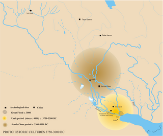
The Jemdet Nasr Period is an archaeological culture in southern Mesopotamia. It is generally dated from 3100 to 2900 BC. It is named after the type site Tell Jemdet Nasr, where the assemblage typical for this period was first recognized. Its geographical distribution is limited to south-central Iraq. The culture of the proto-historical Jemdet Nasr period is a local development out of the preceding Uruk period and continues into the Early Dynastic I period.
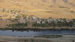
Lake Hamrin, is a man-made lake approximately 50 km (31 mi) north-east of Baqubah, in Iraq's Diyala Governorate. The town of Hamrin sits on the western shore of the lake, both of which are at the southern tip of the Hamrin mountains. The Hemrin Dam, which creates Lake Hamrin, was established in 1981 as an artificial dam to hold over two billion cubic metres of water. It is a source of fish and also provides water for nearby date palm orchards and other farms. In June 2008, it was reported that due to Iranian damming of the Alwand River, the lake had lost nearly 80% of its capacity.
Khafajah or Khafaje, ancient Tutub, is an archaeological site in Diyala Governorate, Iraq 7 miles (11 km) east of Baghdad. Khafajah lies on the Diyala River, a tributary of the Tigris. Occupied from the Uruk and Jemdet Nasr periods through the end of the Old Babylonian Empire, it was under the control of the Akkadian Empire and then the Third Dynasty of Ur in the 3rd millennium BC. It then became part of the empire of the city-state of Eshnunna lying 12 miles (19 km) southwest of that city, about 5 miles (8.0 km) from the ancient city of Shaduppum, and near Tell Ishchali, both which Eshnunna also controlled. It then fell to Babylonia before falling into disuse.
Tell Ishchali is an archaeological site in Diyala Province (Iraq) a few hundred meters from the Diyala River and 3 miles south by southeast from the ancient city of Khafajah. It is thought to be ancient Nerebtum or Kiti and was part of the city-state of Eshnunna. It is known to have been occupied during the Isin-Larsa period and Old Babylonian period with excavations ending before earlier levels were reached.
Tell Agrab is a tell or settlement mound 12.6 miles (20.3 km) southeast of Eshnunna in the Diyala region of Iraq. It is about 15 miles southeast of Tell Asmar, ancient Eshnunna.

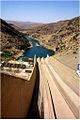
The Hemrin Dam is a dam on the Diyala River 100 km northeast of Baghdad, Iraq. The main purpose of the dam is flood control, irrigation and hydroelectric generation. Its power station has a 50 MW capacity. The dam and the attached power house were built in years 1976-1981 by the then Yugoslav company GIK Hidrogradnja. All the equipment were also supplied by the then-Yugoslav companies.
The Sirwan is a river and tributary of the Tigris that originates in Iran. The Sirwan then runs mainly through eastern Iraq. It covers a total distance of 445 km (277 mi).

The Tell Asmar Hoard are a collection of twelve statues unearthed in 1933 at Eshnunna in the Diyala Governorate of Iraq. Despite subsequent finds at this site and others throughout the greater Mesopotamian area, they remain the definitive example of the abstract style of Early Dynastic temple sculpture.

Dadusha (reigned c. 1800–1779 BC) was one of the kings of the central Mesopotamian city Eshnunna, located in the Diyala Valley. He was the son of the Eshnunna king Ipiq-Adad II. Although previously kings of Eshnunna had referred to themselves as ensi (governor) of the city god Tishpak, in the early 19th century rulers of Eshnunna began referring to themselves as King. Dadusha's father Ipiq-Adad II and his brother Naram-Suen, who ruled Eshnunna before him, both used the title king and Dadusha followed suit.

The Garan Dam is an earth-fill embankment dam on the Garan River, a tributary of the Sirvan River, about 15 km (9.3 mi) northeast of Marivan in Kurdistan Province, Iran. Construction on the dam began in 2002 and it was inaugurated by Iranian President Mahmoud Ahmadinejad on 12 April 2013. It is 62 m (203 ft) tall and impounds a reservoir with a storage capacity of 110,000,000 m3 (89,000 acre⋅ft). The primary purpose of the dam is to supply water for the irrigation of 10,450 ha in Marivan County. It also provides municipal water to the city of Marivan. Officials in Iraq are concerned that the Garan Dam will have a negative impact on the Sirvan River as it feeds the Iraqi Darbandikhan Dam and farmlands below it.

Lower Mesopotamia is a historical region of Mesopotamia. It is located in the alluvial plain of Iraq from the Hamrin Mountains to the Faw Peninsula near the Persian Gulf.
Tell Rashid is a tell, or archaeological settlement mound, in Diyala Governorate, Iraq. The site lies in the foothills of the Zagros Mountains, some 12 km (7.5 mi) south of Tell Abada, another Ubaid period site. It measures 54 by 30 m and extends 2.5 m above the surrounding plain. Tell Rashid was excavated for a single season in 1978 under the direction of Sabah Abboud Jasim as part of the archaeological salvage work being done for the construction of the Hemrin Dam. The excavation trench reached a depth of 5 m, at which point virgin soil was reached. Four different occupation levels were recognised, all dating to the Ubaid period.
Tell Abada is a tell, or archaeological settlement mound, in Diyala Governorate (Iraq). Abada was excavated as part of the archaeological salvage operation to excavate sites that would be flooded by the reservoir of the Hamrin Dam. Excavations revealed occupation levels dating to the Ubaid 1-3 periods. The site is important because it was one of the few where an Ubaid period settlement could be excavated in its entirety.
Tell Madhur is a tell, or archaeological settlement mound, in Diyala Governorate (Iraq). The site was excavated due to it being flooded by the reservoir created by the Hamrin Dam. Madhur is best known for its particularly well-preserved Ubaid house. A significant Early Dynastic occupation, consisting of a rounded building typical for the Hamrin region at the time, has also been attested at Madhur.
Alwand Dam is a dam located on the Alwand River, southeast of Khanaqin, 6 km (3.7 mi) from the Iraqi-Iranian border. It is a hydroponic dam with a mud core with a length of 1,342 m (4,403 ft) and a height of 24 m (79 ft). The storage quantities in the dam's lake is 38,000,000 m3 (1.3×10⁹ cu ft) and the surface area of the lake is 6,200,000 m2 (67,000,000 sq ft).