
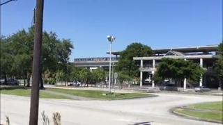
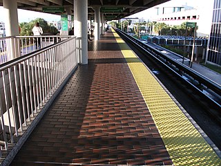
University station is a station on the Metrorail rapid transit system at the University of Miami in Coral Gables, Florida, United States. The station is located at 5400 Ponce de Leon Boulevard at the intersection of Dixie Highway and Mariposa Court.

Tri-Rail and Metrorail Transfer station is a Metrorail and Tri-Rail interchange station in Hialeah, Florida, northwest of the city of Miami proper.
Okeechobee station is a Metrorail station in Hialeah, Florida. The station is located at the intersection of West 20th Street and Okeechobee Road, one block south of the Hialeah Expressway. It opened to passenger service on May 19, 1985, and was previously the northwestern terminus of the Metrorail system until Palmetto station opened in 2003.
Earlington Heights station is a Metrorail station in the Liberty City neighborhood of Miami, Florida. This station is located at the intersection of Northwest 21st Avenue and the Airport Expressway. The Metrorail Orange Line creation and extension of the metro to Miami International Airport (MIA) began construction from this rail station in May 2009, completed in July 2012. Passenger service between MIA, through Downtown Miami, and to the southern Miami suburb of Kendall opened in Summer 2012.

Allapattah station is a Metrorail station in the Allapattah neighborhood of Miami, Florida.
Santa Clara station is a station on the Metrorail rapid transit system in the industrial district of the Allapattah neighborhood in Miami, Florida. This station is located near the intersection of Northwest 12th Avenue and 20th Street. It opened to service December 17, 1984. Along with Brownsville station, Santa Clara is generally the lowest ridership station on the system.

Civic Center station is a station on the Metrorail rapid transit system in the Health District of Miami, Florida. The station is located at the intersection of Northwest 12th Avenue and 15th Street. Civic Center provides a convenient connection for University of Miami medical students by connecting the hospital area to the main campus at University Station.
Culmer station is a station on the Metrorail rapid transit system just northeast of the Spring Garden neighborhood of Miami, Florida, near the Midtown Interchange. This station is located at the intersection of Northwest 11th Street and Seventh Avenue, opening to service December 17, 1984. The station is named after Father John Culmer, a local civil rights leader who worked to improve the living conditions of black Miamians.

Government Center station is an intermodal transit hub in the Government Center district of Downtown Miami, Florida. It is operated by Miami-Dade Transit and serves as a transfer station for the Metrorail and Metromover rapid transit systems and as a bus station for Metrobus, Paratransit, and Broward County Transit buses. MiamiCentral is directly connected via a pedestrian bridge over NW 3rd Street. The station is located near the intersection of Northwest First Street and First Avenue, a part of the Stephen P. Clark Government Center Building. It opened to service May 20, 1984, next to the site of a former FEC railway station which is now MiamiCentral.

Brickell station is a Metrorail rapid transit station in Miami, Florida, serving the system's Green and Orange Lines. One of the core stations of Miami's public transport network, it serves the financial district of Brickell. Combined, the Metrorail and Metromover station complex at Brickell sees roughly 8,430 boardings each weekday, making it the system's second-busiest station.

Coconut Grove station is a station on the Metrorail rapid transit system on the western end of the Coconut Grove neighborhood of Miami, Florida. The station is located at the intersection of South Dixie Highway and West 27th Avenue/Grapeland Boulevard, opening to service on May 20, 1984.
South Miami station is a station on the Metrorail rapid transit system in South Miami, Florida. This station is located at the intersection of South Dixie Highway and Sunset Drive, two blocks west of Red Road. It opened to service May 20, 1984.
Dadeland North station is a station on the Metrorail rapid transit system in the Dadeland district of Glenvar Heights, Florida. This station is located at the intersection of South Dixie Highway and Southwest 83rd Street on the Snapper Creek, two blocks north of Kendall Drive and two blocks south from the US 1–Snapper Creek Expressway junction. It opened to service May 20, 1984.

Dadeland South station is a transfer station on the Metrorail rapid transit system in the Dadeland district of Kendall, Florida. It is the southern terminus of the Metrorail system and the northern terminus of the South Dade TransitWay. It is the southernmost passenger rail station in the Continental United States. This station is located near the intersection of Dadeland Boulevard and Datran Boulevard, adjacent to South Dixie Highway, three blocks southwest of Kendall Drive and Dadeland Mall, and just east of the US 1–Palmetto Expressway junction. It opened to service May 20, 1984.

Historic Overtown / Lyric Theatre station is a station on the Metrorail rapid transit system in northwest Downtown, Miami, Florida. The station is located at the intersection of Northwest Sixth Street and First Avenue, just south of the neighborhood of Overtown and east of the historic Lyric Theatre. It opened on May 20, 1984. Originally called Overtown, the Arena was added to the name in 1988 when the Miami Arena opened. It took on its current name in 2007, one year before the Miami Arena was demolished. This station is within walking distance to MiamiCentral, which serves Tri-Rail and Brightline.

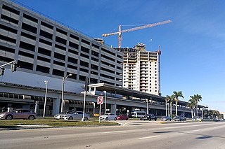
Miami Intermodal Center (MIC) is an intermodal rapid transit, commuter rail, intercity rail, local bus, and intercity bus transportation hub in Miami-Dade County, Florida, just outside the Miami city limits near the Grapeland Heights neighborhood. The facility was constructed by the Florida Department of Transportation and is owned by the Miami-Dade Expressway Authority.

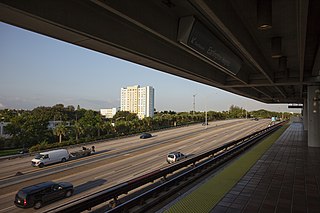
Metrorail is a rapid transit system in Miami and Miami-Dade County in the U.S. state of Florida. Metrorail is operated by Miami-Dade Transit (MDT), a departmental agency of Miami-Dade County. Opened in 1984, it is Florida's only rapid transit metro system, and is currently composed of two lines of 23 stations on 24.4 miles (39.3 km) of standard gauge track. Metrorail serves the urban core of Miami, connecting Miami International Airport, the Health District, Downtown Miami, and Brickell with the northern developed neighborhoods of Hialeah and Medley to the northwest, and to suburban The Roads, Coconut Grove, Coral Gables, and South Miami, ending at urban Dadeland in Kendall. Metrorail connects to the Metromover in Downtown, which provides metro service to the entirety of Downtown and Brickell. Additionally, it connects to South Florida's commuter rail system at Tri-Rail station, as well as Metrobus routes at all stations. In 2023, the system had 13,439,300 rides, and about 48,300 per day in the fourth quarter of 2023.

Vizcaya station is a station on the Metrorail rapid transit service station in The Roads neighborhood of Miami, Florida. The station is located near the intersection of Southwest First Avenue and 32nd Road, at the southern terminus of I-95 at South Dixie Highway two blocks southeast of Coral Way.
Douglas Road, also West 37th Avenue on the greater Miami grid plan and Northwest 88th Avenue in Miramar, is a 20.4-mile (32.8 km) north–south thoroughfare running west of downtown Miami in Miami-Dade County and Broward County, Florida. It changes names and becomes Pine Island Road, at the intersection with Sheridan Street.

The Underline is a 10-mile linear park being developed in Miami-Dade County, Florida. When complete, it will run underneath the county's elevated Metrorail system from the Miami River near Brickell to the Metrorail's southern terminus at Dadeland South. The project is essentially upgrading a pre-existing bike path, known as the M-Path, into a full linear park. As of 2024, the first phase of The Underline was completed in the Brickell area on February 26, 2021. The second phase, which runs from Brickell to just south of Vizcaya station, was completed on April 24, 2024. The third and final phase will be completed in 2026.


