South Carolina is a state in the coastal Southeastern region of the United States. It is bordered to the north by North Carolina, to the southeast by the Atlantic Ocean, and to the southwest by Georgia across the Savannah River. Along with North Carolina, it makes up the Carolinas region of the East Coast. South Carolina is the 40th most extensive and 23rd most populous U.S. state with a recorded population of 5,124,712 according to the 2020 census. In 2019, its GDP was $213.45 billion. South Carolina is composed of 46 counties. The capital is Columbia with a population of 137,300 in 2020; while its largest city is Charleston with a 2020 population of 150,277. The Greenville–Spartanburg-Anderson metropolitan area is the most populous in the state, with a 2020 population estimate of 1,455,892.
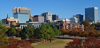
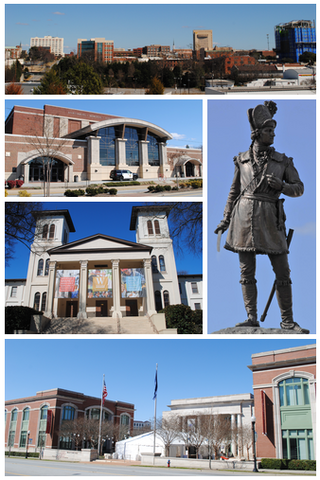
Columbia is the capital city of the U.S. state of South Carolina. With a population of 136,632 at the 2020 census, it is the second-most populous city in South Carolina. The city serves as the county seat of Richland County, and a portion of the city extends into neighboring Lexington County. It is the center of the Columbia, SC Metropolitan Statistical Area, which had a population of 829,470 in 2020 and is the 7th largest urban center in the Deep South and the 72nd-largest metropolitan statistical area in the nation. The name Columbia is a poetic term used for the United States, derived from the name of Christopher Columbus, who explored for the Spanish Crown. Columbia is often abbreviated as Cola, leading to its nickname as "Soda City."

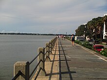
Charleston is the most populous city in the U.S. state of South Carolina, the county seat of Charleston County, and the principal city in the Charleston metropolitan area. The city lies just south of the geographical midpoint of South Carolina's coastline on Charleston Harbor, an inlet of the Atlantic Ocean formed by the confluence of the Ashley, Cooper, and Wando rivers. Charleston had a population of 150,277 at the 2020 census. The 2020 population of the Charleston metropolitan area, comprising Berkeley, Charleston, and Dorchester counties, was 799,636 residents, the third-largest in the state, 8th-largest in the Deep South and the 74th-largest metropolitan statistical area in the United States.

Richland County is located in the U.S. state of South Carolina. As of the 2020 census, its population was 416,147, making it the second-most populous county in South Carolina, behind only Greenville County. The county seat and largest community is Columbia, the state capital. The county was established on March 12, 1785. Richland County is part of the Columbia, SC Metropolitan Statistical Area. In 2020, the center of population of South Carolina was located in Richland County, in the city of Columbia.

Charleston County is located in the U.S. state of South Carolina along the Atlantic coast. As of the 2020 census, the population was 408,235, making it the third most populous county in South Carolina. Its county seat is Charleston. It is also the largest county in the state by land area. The county was created in 1800 by an act of the South Carolina State Legislature.

Berkeley County is a county in the U.S. state of South Carolina. As of the 2020 census, its population was 229,861. Its county seat is Moncks Corner, and the largest community is Goose Creek. After two previous incarnations of Berkeley County, the current county was created in 1882. Berkeley County is included in the Charleston-North Charleston, SC Metropolitan Statistical Area.

Beaufort is a city in and the county seat of Beaufort County, South Carolina, United States. Chartered in 1711, it is the second-oldest city in South Carolina, behind Charleston, which was established in 1670. A city rich in history, culture, southern hospitality, and a seaside charm, Beaufort is affectionately known as the "Queen of the Carolina Sea Islands". The city's population was 13,607 at the 2020 census. It is part of the Hilton Head Island–Bluffton metropolitan area.

Mount Pleasant is a large suburban town in Charleston County, South Carolina, United States. In the Lowcountry, it is the fourth most populous municipality and largest town in South Carolina, and for several years was one of the state's fastest-growing areas, doubling in population between 1990 and 2000. The population was 90,801 at the 2020 census. It is part of the Charleston metropolitan area.

Sullivan's Island, historically known as O'Sullivan's Island, is a town and island in Charleston County, South Carolina, United States, at the entrance to Charleston Harbor, with a population of 1,791 at the 2010 census, and 1,891 people in 2020. The town is part of the Charleston metropolitan area, and is considered a very affluent suburb of Charleston.

Gaffney is a city in and the seat of Cherokee County, South Carolina, United States, in the Upstate region of South Carolina. Gaffney is known as the "Peach Capital of South Carolina". The population was 12,539 at the 2010 census, with an estimated population of 12,609 in 2019. It is the principal city of the Gaffney, South Carolina, Micropolitan Statistical Area, which includes all of Cherokee County and which is further included in the greater Greenville-Spartanburg-Anderson, South Carolina Combined Statistical Area.

Walterboro is a city in Colleton County, South Carolina, United States. The city's population was 5,398 at the 2010 census. It is the county seat of Colleton County. Walterboro is located 48 miles (77 km) west of Charleston and is located near the ACE Basin region in the South Carolina Lowcountry.
Dillon is a city in Dillon County in eastern South Carolina, United States. It is the county seat and largest city of Dillon County. It was established on December 22, 1888. Both the name of the city and county comes from James W. Dillon, an early settler and key figure in bringing a railroad through the area. The population was 6,788 in the 2010 U.S. census.
Conway is a city in Horry County, South Carolina. The population was 24,849 at the 2020 census, up from 17,103 in the 2010 census. It is the county seat of Horry County and is part of the Myrtle Beach metropolitan area. It is the home of Coastal Carolina University.

Clinton is a city in Laurens County, South Carolina, United States. The population was 8,490 as of the 2010 census. It is part of the Greenville–Mauldin–Easley Metropolitan Statistical Area in upstate South Carolina. Clinton is the home of Presbyterian College.

Walhalla is a city in the foothills of the Blue Ridge Mountains in Oconee County, South Carolina. Designated in 1868 as the county seat, it lies within the area of the Blue Ridge Escarpment, an area of transition between mountains and piedmont, and contains numerous waterfalls. It is located 16 miles (26 km) from Clemson University in Clemson, South Carolina.
Spartanburg is a city in and the seat of Spartanburg County, South Carolina, United States. The city had a population of 38,732 as of the 2020 census, making it the 11th-largest city in the state. For a time, the Office of Management and Budget (OMB) grouped Spartanburg and Union counties together as the Spartanburg, SC Metropolitan Statistical Area, but the OMB now defines the Spartanburg, SC MSA as only Spartanburg County.

North Charleston is a city in Berkeley, Charleston, and Dorchester counties within the U.S. state of South Carolina. As of the 2020 census, North Charleston had a population of 114,852, making it the 3rd most populous city in the state, and the 248th most populous city in the United States. North Charleston is a principal city within the Charleston-North Charleston, SC Metropolitan Statistical Area, which had a population of 799,636 in 2020.

Interstate 526 (I-526) is a 19.56-mile (31.48 km) auxiliary route of I-26, providing a partial beltway around Charleston, South Carolina, in the United States. The route serves several purposes, firstly, as a bypass for through traffic on U.S. Route 17 (US 17) to avoid downtown Charleston, and, secondly, for traffic on I-26 bound for the coastal towns located north and south of Charleston. The route is not yet complete, as the western terminus it is planned for the route to be extended an additional 10 miles (16 km). After the eastern terminus, the roadway continues as a short business route, known as Interstate 526 Business.

Interstate 26 (I-26) is a South Carolina Interstate highway running generally east–west from near Landrum, in Spartanburg County, to U.S. Route 17 (US 17), in Charleston, South Carolina. It is also the longest Interstate Highway in South Carolina.
The architecture of Charleston, the largest city in the US state of South Carolina, has English and Barbadian influences.