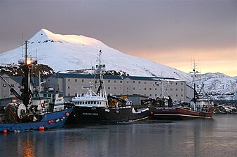
The City of Unalaska is the main population center in the Aleutian Islands. The city is in the Aleutians West Census Area, a regional component of the Unorganized Borough in the U.S. state of Alaska. Unalaska is located on Unalaska Island and neighboring Amaknak Island in the Aleutian Islands off mainland Alaska. The population was 4,254 at the 2020 census, which is 81% of the entire Aleutians West Census Area. Unalaska is the second largest city in the Unorganized Borough, behind Bethel.

Attu is an island in the Near Islands. It is the westernmost point of the U.S. state of Alaska. The island became uninhabited in 2010, making it the largest uninhabited island to be politically part of the United States.
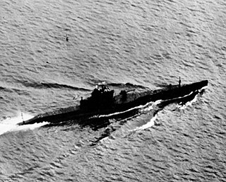
USS S-28 (SS-133) was an S-class submarine of the United States Navy. A diesel submarine, she served in World War II during which sank one Japanese ship. She was lost at sea with all hands in July 1944. Her wreck was discovered in 2017 at a depth of 8,500 feet (2,600 m) off the coast of Oahu.

Kiska is one of the Rat Islands, a group of the Aleutian Islands of Alaska. It is about 22 miles (35 km) long and varies in width from 1.5 to 6 miles. It is part of Aleutian Islands Wilderness and as such, special permission is required to visit it. The island has no permanent population.
Umnak is one of the Fox Islands of the Aleutian Islands. With 686.01 square miles (1,776.76 km2) of land area, it is the third largest island in the Aleutian archipelago and the 19th largest island in the United States. The island is home to a large volcanic caldera on Mount Okmok and the only field of geysers in Alaska. It is separated from Unalaska Island by Umnak Pass. In 2000, Umnak was permanently inhabited by only 39 people and by 2010, around 18, placing the settlement of Nikolski in difficulty and its school was closed.
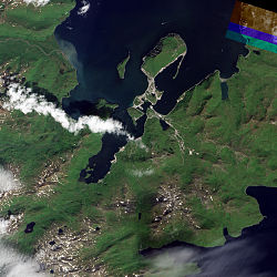
Amaknak Island or Umaknak Island is the most populated island in the Aleutian Islands, an archipelago which is part of the U.S. state of Alaska.

The Aleutian Islands campaign was a military campaign fought between 3 June 1942 and 15 August 1943 on and around the Aleutian Islands in the American Theater of World War II. It was the only military campaign of World War II fought on North American soil.

USS S-34 (SS-139) was an S-class submarine of the United States Navy.
USS S-31 (SS-136) was a first-group S-class submarine of the United States Navy.
USS S-23 (SS-128) was a first-group S-class submarine of the United States Navy.

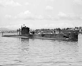
USS S-18 (SS-123) was a first-group S-class submarine of the United States Navy in commission from 1924 to 1945. She served during World War II, seeing duty primarily in the Aleutian Islands campaign.

USCGC Onondaga (WPG-79), a United States Coast Guard cutter, was built by Defoe Boat Works in Bay City, Michigan, commissioned on 11 September 1934. From its commissioning until 1941, Onondaga was stationed at Astoria, Oregon, where she performed important law enforcement duties and rendered much assistance to ships in distress. Each year she patrolled the annual pelagic seal migration to the Pribilof Islands, and she attempted to prevent out of season halibut fishing.
The Aleutian World War II National Historic Area is a U.S. National Historic Site on Amaknak Island in the Aleutian Island Chain of Alaska. It offers visitors a glimpse of both natural and cultural history, and traces the historic footprints of the U.S. Army Base, Fort Schwatka, located at the Ulakta Head on Mount Ballyhoo. The fort, 800 miles west of Anchorage, the nearest large urban center, was one of four coastal defense posts built to protect Dutch Harbor during World War II; Fort Schwatka is also the highest coastal battery ever constructed in the United States. The other Army coastal defense facilities were Fort Mears, Fort Learnard, and Fort Brumback. Engineers designed the concrete observation posts and command stations to withstand earthquakes and 100 mph winds. Although today, many of the bunkers and wooden structures of Fort Schwatka have collapsed, the gun mounts and lookouts are among the most intact in the country.
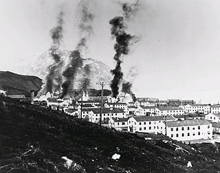
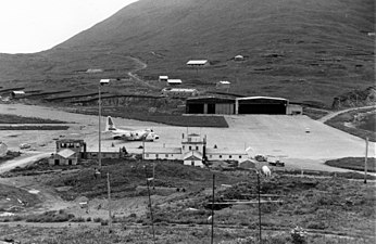
The Battle of Dutch Harbor took place on 3-4 June 1942, when the Imperial Japanese Navy launched two aircraft carrier raids on the Dutch Harbor Naval Operating Base and U.S. Army Fort Mears at Dutch Harbor on Amaknak Island, opening the Aleutian Islands campaign of World War II. The bombing marked the first aerial attack by an enemy on the continental United States and was the second time in history that the continental U.S. was bombed by someone working for a foreign power, the first being the accidental bombing of Naco, Arizona, in 1929.

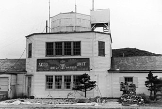
The Dutch Harbor Naval Operating Base and Fort Mears were the two military installations built next to each other in Dutch Harbor, on Amaknak Island of the Aleutian Islands in Alaska, by the United States in response to the growing war threat with Imperial Japan during World War II. In 1938, the Navy Board recommended the construction which began in July 1940. The first United States Army troops arrived in June 1941 and an air base constructed by the United States Navy was finished in September 1941. At the time of the surprise attack on Pearl Harbor, these were the only military installations in the Aleutian Islands.

Unalaska is a volcanic island in the Fox Islands group of the Aleutian Islands in the US state of Alaska located at 53°38′N167°00′W. The island has a land area of 1,051 square miles (2,720 km2). It measures 79.4 mi (127.8 km) long and 34.7 mi (55.8 km) wide. The city of Unalaska, Alaska, covers part of the island and all of neighboring Amaknak Island where the Port of Dutch Harbor is located. The population of the island excluding Amaknak as of the 2000 census was 1,759 residents.

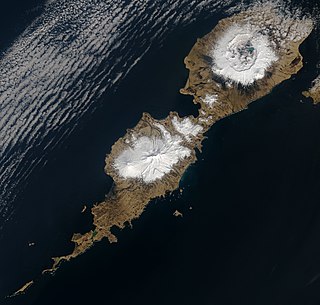
The Aleutian Islands, also called the Aleut Islands or Aleutic Islands and known before 1867 as the Catherine Archipelago, are a chain of 14 large volcanic islands and 55 smaller islands. Most of the Aleutian Islands belong to the U.S. state of Alaska, but some belong to the Russian federal subject of Kamchatka Krai. They form part of the Aleutian Arc in the Northern Pacific Ocean, occupying a land area of 6,821 sq mi (17,666 km2) and extending about 1,200 mi (1,900 km) westward from the Alaska Peninsula toward the Kamchatka Peninsula in Russia, and act as a border between the Bering Sea to the north and the Pacific Ocean to the south. Crossing longitude 180°, at which point east and west longitude end, the archipelago contains both the westernmost part of the United States by longitude and the easternmost by longitude. The westernmost U.S. island in real terms, however, is Attu Island, west of which runs the International Date Line. While nearly all the archipelago is part of Alaska and is usually considered as being in the "Alaskan Bush", at the extreme western end, the small, geologically related Commander Islands belong to Russia.

The Japanese occupation of Attu was the result of an invasion of the Aleutian Islands in Alaska during World War II. Imperial Japanese Army troops landed on 7 June 1942, the day after the invasion of nearby Kiska. Along with the Kiska landing, it was the first time that the continental United States was invaded and occupied by a foreign power since the War of 1812, and was the second of the only two invasions of the United States during World War II. The occupation ended with the Allied victory in the Battle of Attu on 30 May 1943.

The military history of the Aleutian Islands began almost immediately following the purchase of Alaska from the Russian Empire by the United States in 1867. Prior to the early 20th century, the Aleutian Islands were essentially ignored by the United States Armed Forces, although the islands played a small role in the Bering Sea Arbitration when a number of British and American vessels were stationed at Unalaska to enforce the arbitrators' decision. By the early 20th century, a number of war strategies examined the possibility of conflict breaking out between the Empire of Japan and the United States. While the Aleutian Islands were seen as a potential staging point for invasions by either side, this possibility was dismissed owing to the islands' dismal climate. In 1922, the Washington Naval Treaty was signed, after which the United States Navy began to take an interest in the islands. However, nothing of significance was to materialize until World War II.

USFS Eider was an American motor schooner in commission in the fleet of the United States Bureau of Fisheries from 1919 to 1940 and, as US FWS Eider, in the fleet of the U.S. Fish and Wildlife Service from 1940 to 1942 and again in the late 1940s. She ran a passenger-cargo service between Unalaska and the Pribilof Islands, and also carried passengers, supplies, and provisions to destinations on the mainland of the Territory of Alaska and in the Aleutian Islands. She occasionally supported research activities in Alaskan waters and the North Pacific Ocean, and she conducted patrols to protect Alaskan fisheries and marine mammals. In 1924, she provided logistical support to the first aerial circumnavigation of the world.