Cape Breton Island is an island on the Atlantic coast of North America and part of the province of Nova Scotia, Canada.

Nova Scotia is a province in eastern Canada. With a population of 923,598 as of 2016, it is the most populous of Canada's three Maritime provinces and the four Atlantic provinces. It is the country's second-most densely populated province and second-smallest province by area, both after neighbouring Prince Edward Island. Its area of 55,284 square kilometres (21,345 sq mi) includes Cape Breton Island and 3,800 other coastal islands. The peninsula that makes up Nova Scotia's mainland is connected to the rest of North America by the Isthmus of Chignecto, on which the province's land border with New Brunswick is located. The province borders the Bay of Fundy to the northwest and the Atlantic Ocean to the south and east, and is separated from Prince Edward Island and the island of Newfoundland by the Northumberland and Cabot straits, respectively.

Cape Breton University (CBU), formerly known as the "University College of Cape Breton" (UCCB), is a university in the Cape Breton Regional Municipality, Nova Scotia, Canada. Located near Sydney, CBU is the only post-secondary degree-granting institution on Cape Breton Island. The university is enabled by the Cape Breton University Act passed by the Nova Scotia House of Assembly. Prior to this, CBU was enabled by the University College of Cape Breton Act (amended). The University College of Cape Breton's Coat of Arms were registered with the Canadian Heraldic Authority on May 27, 1995.

Sydney is a former city and current community located in the Cape Breton Regional Municipality of Cape Breton Island, Nova Scotia, Canada. Situated on Cape Breton Island's east coast, it belongs administratively to the Cape Breton Regional Municipality. Sydney was founded in 1785 by the British, was incorporated as a city in 1904, and dissolved on 1 August 1995, when it was amalgamated into the regional municipality.

Cape Breton Highlands National Park is a Canadian national park on northern Cape Breton Island in Nova Scotia. The park was the first national park in the Atlantic provinces of Canada and covers an area of 948 square kilometres (366 sq mi). It is one of 42 in Canada's system of national parks.

Truro is a town in central Nova Scotia, Canada. Truro is the shire town of Colchester County and is located on the south side of the Salmon River floodplain, close to the river's mouth at the eastern end of Cobequid Bay.

Baddeck is a village in Victoria County, Nova Scotia, Canada. This village is seventy-eight kilometres west of Sydney. It is Victoria County's shire town and is situated on the northern shore of Bras d'Or Lake on Cape Breton Island.

Cape Breton Regional Municipality, often referred to as simply CBRM, is the Canadian province of Nova Scotia's second largest municipality and the economic heart of Cape Breton Island. As of 2016 the municipality has a population of 94,285. The municipality was created in 1995 through the amalgamation of eight municipalities located in Cape Breton County.
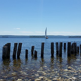
Bras d'Or Lake is an inland sea, or large body of partially fresh/salt water in the centre of Cape Breton Island in the province of Nova Scotia, Canada. Bras d'Or Lake is sometimes referred to as the Bras d'Or Lakes or the Bras d'Or Lakes system; however, its official geographic name is Bras d'Or Lake, as it is a singular entity. Canadian author and yachtsman Silver Donald Cameron describes Bras d'Or Lake as "A basin ringed by indigo hills laced with marble. Islands within a sea inside an island." The lake is connected to the North Atlantic by natural channels; the Great Bras d'Or Channel north of Boularderie Island and the Little Bras d'Or Channel to south of Boularderie Island connect the northeastern arm of the lake to the Cabot Strait. The Bras d'Or is also connected to the Atlantic Ocean via the Strait of Canso by means of a lock canal completed in 1869—the St. Peters Canal, at the southern tip of the lake.
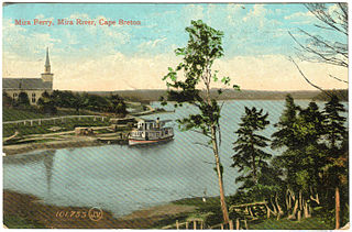
The Mira River is a Canadian river located in eastern Cape Breton Island, Nova Scotia.
The Eastern Shore is a region of the Canadian province of Nova Scotia. It is the Atlantic coast running northeast from Halifax Harbour to the eastern end of the peninsula at the Strait of Canso.

Arichat is a Canadian village in Nova Scotia. It is one of the oldest communities in the province, dating back to the 18th century.
Dingwall is a coastal community of approximately 600 residents in the Aspy Bay region of Victoria County, Nova Scotia, Canada. It is situated just off the Cabot Trail, 84.68 kilometers northeast of county seat Baddeck. The federal electoral riding is Sydney—Victoria.

Nova Scotia is a province located in Eastern Canada fronting the Atlantic Ocean. One of the Maritime Provinces, Nova Scotia's geography is complex, despite its relatively small size in comparison to other Canadian provinces.
Donkin is a Canadian rural village with a population of 573. It is located on the picturesque coastline of Nova Scotia's Cape Breton Island. The smaller communities of Port Caledonia and Schooner Pond are directly adjacent to the village proper, connected by a single strip of road called the Donkin Highway.
Port Morien is a small fishing community of 700 people in the Canadian province of Nova Scotia, located in the southeastern Cape Breton Island near the rural community Donkin, and six miles from the town of Glace Bay.

Spanish Bay is a bay in the Canadian province of Nova Scotia. It is located on the Atlantic coast of Cape Breton Island at the mouth of Sydney Harbour, which forms part of Spanish Bay. The current name for the bay, "Spanish Bay" appears on maps of the area at least as far back as 1708.
East Bay is a bay of the Bras d'Or Lake on Cape Breton Island in the Canadian province of Nova Scotia. It lies entirely within Cape Breton County.

Wilkie Sugar Loaf is a Canadian peak in the Cape Breton Highlands near the community of Sugar Loaf in the province of Nova Scotia.
The following outline is provided as an overview of and topical guide to Nova Scotia: