
A courthouse or court house is a building that is home to a local court of law and often the regional county government as well, although this is not the case in some larger cities. The term is common in North America. In most other English-speaking countries, buildings which house courts of law are simply called "courts" or "court buildings". In most of continental Europe and former non-English-speaking European colonies, the equivalent term is a palace of justice.
In local government, a city hall, town hall, civic centre, guildhall, or a municipal building, is the chief administrative building of a city, town, or other municipality. It usually houses the city or town council, its associated departments, and their employees. It also usually functions as the base of the mayor of a city, town, borough, county or shire, and of the executive arm of the municipality. Other terms in non-English languages are Mairie or Hôtel de ville (France), Gemeindehaus or Rathaus (Germany), Rådhus (Denmark), Paços do Concelho (Portugal), Stadhuis and Stadshus (Sweden).

Toronto Chinatowns are ethnic enclaves in Toronto, Ontario, Canada, with a high concentration of ethnic Chinese residents and businesses. These neighbourhoods are major cultural, social and economic hubs for the Chinese-Canadian communities of the region. In addition to Toronto, several areas in the Greater Toronto Area also hold a high concentration of Chinese residents and businesses.
The Municipality of Metropolitan Toronto was an upper-tier level of municipal government in Ontario, Canada, from 1953 to 1998. It was made up of the old city of Toronto and numerous townships, towns and villages that surrounded Toronto, which were starting to urbanize rapidly after World War II. It was commonly referred to as "Metro Toronto" or "Metro".
York is a former city within the current city of Toronto, Ontario, Canada. It is located northwest of Old Toronto, southwest of North York and east of Etobicoke, where it is bounded by the Humber River. The city has a population of 145,662 as of 2016.

East York is a former administrative district and municipality within Toronto, Ontario, Canada. From 1967 to 1998, it was officially the Borough of East York, a semi-autonomous borough within the upper-tier municipality of Metropolitan Toronto.
North York City Centre is a central business district in Toronto, Ontario, Canada in the administrative district of North York. It is located along Yonge Street, between just south of Sheppard Avenue northward to Finch Avenue with its focus around Mel Lastman Square, a civic square, and spreads eastwards and westwards a few blocks, generally as far as Doris Avenue and Beecroft Road. The district is a high-density district of condominium and office towers with ground-floor commercial uses along the wide six lanes of Yonge Street.

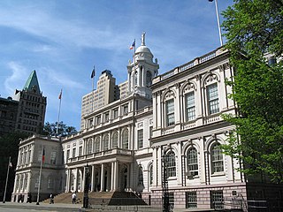
The Toronto City Hall, or New City Hall, is the seat of the municipal government of Toronto, Ontario, Canada, and one of the city's most distinctive landmarks. Designed by Viljo Revell and engineered by Hannskarl Bandel, the building opened in 1965. It replaced the neighbouring Old City Hall, which was occupied by the municipal government since 1899 and continues to house municipal offices and courts. The new city hall is located adjacent to Nathan Phillips Square at the northwest intersection of Bay Street and Queen Street.

Lawrence Heights is a neighbourhood in Toronto, Ontario, Canada. It is located north-west of central Toronto, in the district of North York. The neighbourhood is roughly bounded by Lawrence Avenue to the south, Yorkdale Road to the north, Varna Drive to the east and Dufferin Street to the west. It is part of the greater Yorkdale-Glen Park official Toronto neighbourhood.
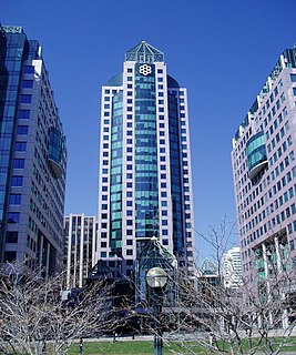
Metro Hall is a 27-storey Postmodern-style office tower at the corner of Wellington and John Street in the downtown core of Toronto, Ontario, Canada. It looks out onto Pecaut Square. Part of the three-tower Metro Centre complex, the building was completed in 1992 to house the Municipality of Metropolitan Toronto (Metro) and its employees. The building is now used by the City of Toronto following municipal consolidation in 1998.

The Scarborough Civic Centre is a civic centre located in the Scarborough district of Toronto, Ontario, Canada. It was designed by architect Raymond Moriyama during the development of Scarborough City Centre and initially opened as the city hall of the former borough of Scarborough by then mayor Albert Campbell and Queen Elizabeth II in 1973. The building served as the municipal office and office for the Scarborough Board of Education. Following the amalgamation of Toronto, Scarborough lost its city status and the civic centre became a secondary hub for the City of Toronto government. It is also home to the Scarborough Community Council and offices of the Toronto District School Board.

The North York Civic Centre is a municipal government building in Toronto, Ontario, Canada. It opened in 1979 as the city hall of the former city of North York. It is located in North York City Centre.

The York Civic Centre is a government building in Toronto, Ontario, Canada. It is located at 2700 Eglinton Avenue West in the neighbourhood of Beechborough-Greenbrook. The building is used by the Toronto West Court Office and was the seat of the municipal government of the former city of York, Ontario.

The Etobicoke Civic Centre in the Eatonville neighbourhood of Toronto, Ontario, Canada, once housed the municipal government of the former City of Etobicoke.

The Mississauga Civic Centre is the seat of local government of Mississauga, Ontario, Canada. The 37,280 square metre complex is a prominent example of postmodern architecture in Canada, finished in 1987 by Jones and Kirkland. It stands at 92 metres or 302 feet. The design was influenced by farmsteads which once occupied much of Mississauga as well as historical features of city centres. The building, for instance, includes a prominent clock tower. It was chosen as the winner of a design competition that included 246 submissions. Mississauga Civic Centre is located in the City Centre near Square One Shopping Centre and is home to the Mississauga City Council. The civic center building is considered one of the most iconic and recognizable buildings and cultural icons of Mississauga city.

Yorkville Town Hall was the municipal building for the Village of Yorkville before its annexation by the City of Toronto. Built in 1859-1860 by architect William Hay and his apprentice Henry Langley, the three-storey building also served as an omnibus stop. The hall was located north of Bloor Street on Yonge Street, along the west side.

Islington-City Centre West is a commercial and residential neighbourhood in Etobicoke, Toronto, Ontario, Canada. One of four central business districts outside Downtown Toronto, it is bounded by Rathburn Road to the north, Islington Avenue to the east, Bloor Street to the south, Mimico Creek to the west.

Lawrence Manor is a neighbourhood in the city of Toronto, Ontario, Canada. This neighbourhood is bounded by Bathurst Street on the east, Highway 401 to the north, the Allen to the west, and Lawrence Avenue to the south. The western side of the area borders along Bathurst Heights and the large public housing project.

The Markham Civic Centre is the city hall of the city of Markham, Ontario. The brick and glass Civic Centre was designed by architect Arthur Erickson with Richard Stevens Architects Limited and opened on May 25, 1990. Entrances, except the great hall entrance, are named after communities in Markham. The building is adjacent to an 11.5-hectare park with a large pond reflecting the south façade.
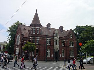
Our City, more formally Our City O-Tautahi, also known as the Old Municipal Chambers, is a Queen Anne style building on the corner of Worcester Street and Oxford Terrace in the Christchurch Central City. It is a Category I heritage building registered with Heritage New Zealand. From 1887 to 1924 it was used by Christchurch City Council as their civic offices, providing room for meetings of the council and for housing staff, before they moved to the Civic. It was then used for many decades by the Canterbury Chamber of Commerce and served as the main tourist information. It was last used as an exhibition and events centre before being damaged in the Christchurch earthquakes.

