Related Research Articles

An ecoregion or ecozone is an ecologically and geographically defined area that is smaller than a bioregion, which in turn is smaller than a biogeographic realm. Ecoregions cover relatively large areas of land or water, and contain characteristic, geographically distinct assemblages of natural communities and species. The biodiversity of flora, fauna and ecosystems that characterise an ecoregion tends to be distinct from that of other ecoregions. In theory, biodiversity or conservation ecoregions are relatively large areas of land or water where the probability of encountering different species and communities at any given point remains relatively constant, within an acceptable range of variation.

A biogeographic realm or ecozone is the broadest biogeographic division of Earth's land surface, based on distributional patterns of terrestrial organisms. They are subdivided into bioregions, which are further subdivided into ecoregions.
Ecological classification or ecological typology is the classification of land or water into geographical units that represent variation in one or more ecological features. Traditional approaches focus on geology, topography, biogeography, soils, vegetation, climate conditions, living species, habitats, water resources, and sometimes also anthropic factors. Most approaches pursue the cartographical delineation or regionalisation of distinct areas for mapping and planning.
A bioregion is an ecologically and geographically defined area that is smaller than a biogeographic realm, but larger than an ecoregion or an ecosystem, in the World Wide Fund for Nature classification scheme. There is also an attempt to use the term in a rank-less generalist sense, similar to the terms "biogeographic area" or "biogeographic unit".

The Boreal Shield Ecozone, as defined by the Commission for Environmental Cooperation (CEC), is the largest ecozone in Canada. Covering 1.8 million square kilometres it covers almost 20% of Canada's landmass, stretching from northern Saskatchewan to Newfoundland.
The environment is the subject of ministries at the federal and provincial level in Canada, with the current highest environmental government official being the national Minister of the Environment Steven Guilbeault. Canada's large landmass and coastline make it very susceptible to any climate changes, so any contemporary changes of climate in the country are of national concern. Of the factors caused by human intervention that can affect this environment, activities that sustain the economy of Canada such as oil and gas extraction, mining, forestry and fishing are influential. The increase in greenhouse gas emissions in Canada between 1990 and 2015 was mainly due to larger emissions from mining, oil, and gas extraction and transport. In 2011 United Nations said Canada's environment was the best in the world.
The Lower Mainland Ecoregion is the biogeoclimatic region that surrounds Vancouver, British Columbia, comprising the eastern edge of the Georgia Depression and extending from Powell River, British Columbia on the Sunshine Coast to Hope at the eastern end of the Fraser Valley. It thus corresponds, for the most part, with the popular usage of the term "Lower Mainland." The Lower Mainland Ecoregion is a part of the Pacific Maritime Ecozone.

Mount Price is a small stratovolcano in the Garibaldi Ranges of the Pacific Ranges in southwestern British Columbia, Canada. It has an elevation of 2,049 metres and rises above the surrounding landscape on the western side of Garibaldi Lake in New Westminster Land District. The mountain contains a number of subfeatures, including Clinker Peak on its western flank, which was the source of two thick lava flows between 15,000 and 8,000 years ago that ponded against glacial ice. These lava flows are structurally unstable, having produced large landslides as recently as the 1850s. A large provincial park surrounds Mount Price and other volcanoes in its vicinity. It lies within an ecological region that surrounds much of the Pacific Ranges.

Yarrow is a small community located 90 kilometres east of Vancouver within the City of Chilliwack in British Columbia, Canada. It is in the Fraser Valley at the foot of Vedder Mountain. The village was first settled by Mennonites in the late 1920s, following the draining of Sumas Lake and the reclamation of the former lake bed for agriculture.

The concept of Cascadian bioregionalism is closely identified with the environmental movement. In the early 1970s, the contemporary vision of bioregionalism began to be formed through collaboration between natural scientists, social and environmental activists, artists and writers, community leaders, and back-to-the-landers who worked directly with natural resources. A bioregion is defined in terms of the unique overall pattern of natural characteristics that are found in a specific place. The main features are generally obvious throughout a continuous geographic terrain and include a particular climate, local aspects of seasons, landforms, watersheds, soils, and native plants and animals. People are also counted as an integral aspect of a locale's life, as can be seen in the ecologically adaptive cultures of early inhabitants, and in the activities of present-day reinhabitants who attempt to harmonize in a sustainable way with the place where they live.
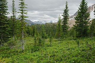
The Montane Cordillera Ecozone, as defined by the Commission for Environmental Cooperation (CEC), is an ecozone in south-central British Columbia and southwestern Alberta, Canada. A rugged and mountainous ecozone spanning 473,000 square kilometres, it still contains "two of the few significant agricultural areas of the province", the Creston Valley and the Okanagan Valley. Primarily a mountainous region, it consists of rugged ecosystems such as alpine tundra, dry sagebrush and dense conifer forests. The interior plains are encircled by a ring of mountains. The area has a mild climate throughout the year, with typically dry summers and wet winters.

Canada is divided into 15 ecozones, forming the country's first level of ecological land classification within the Ecological Land Classification framework adopted in 2017. They represent areas of the earth's surface representative of large and very generalized ecological units characterized by interactive and adjusting biotic and abiotic factors. These ecozones can be further subdivided into 53 ecoprovinces, 194 ecoregions, and 1,027 ecodistricts.
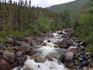
The Atlantic Maritime Ecozone, as defined by the Commission for Environmental Cooperation (CEC), is an ecozone which covers the Canadian provinces of Prince Edward Island, Nova Scotia, and New Brunswick, as well as the Gaspé Peninsula of Quebec. It is adjacent to the Atlantic Marine Ecozone to the east, and the Mixedwood Plains to the west. The roughly-corresponding Level I Ecoregion to this ecozone in the United States Environmental Protection Agency's classification, which is also part of the CEC system, is the Northern Forests ecoregion, though that classification includes the woodlands and swamps of northern Michigan and Minnesota, which are adjacent to the Boreal Shield ecozone.

The Boreal Plains Ecozone, as defined by the Commission for Environmental Cooperation (CEC), is a terrestrial ecozone in the western Canadian provinces of Manitoba, Saskatchewan and Alberta. It also has minor extensions into northeastern British Columbia and south-central Northwest Territories. The region extends over 779,471 km2, of which 58,981 km2 is conserved.
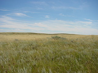
The Prairies Ecozone is a Canadian terrestrial ecozone which spans the southern areas of the Prairie provinces of Alberta, Saskatchewan, and Manitoba. It is a productive agricultural area, and is commonly referred to as "Canada's breadbasket". Farmland covers about 94% of the land, and is the dominant domestic economic activity of the zone, as well as an important factor in Canadian foreign trade. Natural gas and oil are abundant in the area. The corresponding Level II ecoregion of the US Environmental Protection Agency is the Great Plains Ecoregion.
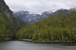
The Pacific Maritime Ecozone, as defined by the Commission for Environmental Cooperation (CEC), is a Canadian terrestrial ecozone, spanning a strip approximately 200 kilometres wide along the British Columbia Coast, then narrowing along the border with Alaska. It also includes all marine islands of British Columbia and a small portion of the southwestern corner of the Yukon. Fourteen ecoregions comprise the Ecozone, ranging from the Mount Logan Ecoregion in the north to the Cascade Ecoregion and Lower Mainland Ecoregion in the south.
An ecosection is a biogeographic unit smaller than an ecoregion that contains minor physiographic, macroclimatic or oceanographic variations. They are a virtual ecological zone in the Canadian province of British Columbia, which contains 139 ecosections that vary from pure terrestrial units to pure marine units.
Bernice Wildlife Management Area is a wildlife management area located northeast of Melita, Manitoba, Canada. It is 65 hectares (0.25 sq mi) in size.
References
- ↑ Denis A.Demarchi (1996). An Introduction to the Ecoregions of British Columbia, Wildlife Branch, Ministry of Environment, Lands and Parks, Victoria, British Columbia
- ↑ Government of Canada, Statistics Canada (2018-01-10). "Introduction to the Ecological Land Classification (ELC) 2017". www.statcan.gc.ca. Retrieved 2020-11-09.
| | This ecology-related article is a stub. You can help Wikipedia by expanding it. |
| | This ecoregion article is a stub. You can help Wikipedia by expanding it. |