Tain is a royal burgh and parish in the County of Ross, in the Highlands of Scotland.

Inverurie is a town in Aberdeenshire, Scotland at the confluence of the rivers Ury and Don, about 16 miles (26 km) north-west of Aberdeen.

A Pictish stone is a type of monumental stele, generally carved or incised with symbols or designs. A few have ogham inscriptions. Located in Scotland, mostly north of the Clyde-Forth line and on the Eastern side of the country, these stones are the most visible remaining evidence of the Picts and are thought to date from the 6th to 9th century, a period during which the Picts became Christianized. The earlier stones have no parallels from the rest of the British Isles, but the later forms are variations within a wider Insular tradition of monumental stones such as high crosses. About 350 objects classified as Pictish stones have survived, the earlier examples of which holding by far the greatest number of surviving examples of the mysterious symbols, which have long intrigued scholars.

Aberlour is a village in Moray, Scotland, 12 miles (20 km) south of Elgin on the road to Grantown. The Lour burn is a tributary of the River Spey, and it and the surrounding parish are both named Aberlour, but the name is more commonly used in reference to the village which straddles the stream and flanks the Spey – although the full name of the village is Charlestown of Aberlour.
Portmahomack is a small fishing village in Easter Ross, Scotland. It is situated in the Tarbat Peninsula in the parish of Tarbat. Tarbat Ness Lighthouse is about three miles from the village at the end of the Tarbat Peninsula. Ballone Castle lies about one mile from the village. There is evidence of early settlement, and the area seems to have been the site of significant activity during the time of the Picts, early Christianity and the Vikings. The village is situated on a sandy bay and has a small harbour designed by Thomas Telford: it shares with Hunstanton the unusual distinction of being on the east coast but facing west. Portmahomack lies inside the Moray Firth Special Area of Conservation with the associated dolphin and whale watching activity.

Brora is a village in the east of Sutherland, in the Highland area of Scotland.

Bonar Bridge is a village on the north bank of the Kyle of Sutherland to the west and the Dornoch Firth to the east in the Parish of Creich in the Highland council area of Scotland.
Balblair Distillery is a Scotch whisky distillery located in Edderton, Ross-shire, Scotland.

Shandwick, a village near Tain in Easter Ross, and is in the Scottish council area of Highland, Scotland.

Evanton is a small village in Easter Ross, in the Highland council area of Scotland. It lies between the River Sgitheach and the Allt Graad, is 24 kilometres (15 mi) north of Inverness, some 6.5 km (4.0 mi) south-west of Alness, and 10 km (6.2 mi) northeast of Dingwall.

Fearn railway station is a railway station serving the village of Hill of Fearn in the Highland council area of Scotland, located around 1.3 miles (2.1 km) from the village. It is situated on the Far North Line, 40 miles 60 chains (65.6 km) form Inverness, between Tain and Invergordon, and is also the nearest station to Balintore, Hilton and Shandwick, Portmahomack and the Nigg Bay area of Easter Ross. ScotRail, who manage the station, operate all services.

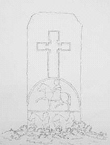
Edderton Cross Slab is a Class III Pictish stone standing in the old graveyard of the village of Edderton, Easter Ross. The stone is of red sandstone. On the western side there is an undecorated but elegant celtic cross, the circles within its rings emphasised by being left in relief. On the eastern side there is another cross on the upper half, standing on a semi-circular base or arch, within which is a horseman in relief, with two further riders incised below. The slab was formerly sunk considerably deeper in the earth, concealing the lower two horsemen, but has recently been raised to its presumed original height.
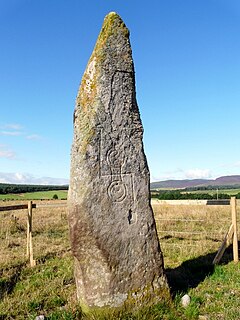
Clach Chairidh, alternatively named Clach Biorach, is a Class I Pictish stone located in a field near the village of Edderton in Easter Ross.
Muir of Ord is a village in Easter Ross, in the Highland council area of Scotland. It is situated near the western end of the Black Isle, about 9 miles (14 km) west of the city of Inverness and 5+1⁄2 miles (9 km) south of Dingwall. The village has a population of 2,840 and sits 35 metres (115 ft) above sea level. The Scottish geologist Sir Roderick Murchison was born in the village in 1792.
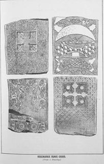
The Rosemarkie Stone or Rosemarkie Cross, a Class II Pictish stone, is one of the major surviving examples of Pictish art in stone.

Meigle is a village in Strathmore, Scotland. It lies in the council area of Perth and Kinross in the Coupar Angus and Meigle ward. It lies on the A94 road between Perth and Forfar. Other smaller settlements nearby are Balkeerie, Kirkinch and Kinloch. Meigle is accessed from the north and south via the B954 road. In 1971 it had a population of 357.

Strathcarron is a hamlet, in the Highland council area of Scotland.
Balleigh is a small village, 0.5 miles southeast of Edderton and 7 miles west of Tain, in eastern Ross-shire, Scottish Highlands and is in the Scottish council area of Highland.

The Tain & District Museum, is located in Tain, Ross-shire, Scotland. It is volunteer-run and is open April to October part of the Tain Through Time visitor centre. The museum was established in 1966 and has a collection of silver made in the local area.

Edderton railway station served the village of Edderton, Highland, Scotland from 1864 to 1960 on the Inverness and Ross-shire Railway.