Veracruz, formally Veracruz de Ignacio de la Llave, officially the Estado Libre y Soberano de Veracruz de Ignacio de la Llave, is one of the 31 states which, along with Mexico City, comprise the 32 Federal Entities of Mexico. Located in eastern Mexico, Veracruz is bordered by seven states, which are Tamaulipas, San Luis Potosí, Hidalgo, Puebla, Oaxaca, Chiapas, and Tabasco. Veracruz is divided into 212 municipalities, and its capital city is Xalapa-Enríquez.
The Huastec or Téenek are an indigenous people of Mexico, living in the La Huasteca region including the states of Hidalgo, Veracruz, San Luis Potosí and Tamaulipas concentrated along the route of the Pánuco River and along the coast of the Gulf of Mexico.
Papantla is a city and municipality located in the north of the Mexican state of Veracruz, in the Sierra Papanteca range and on the Gulf of Mexico. The city was founded in the 13th century by the Totonacs and has dominated the Totonacapan region of the state since then. The region is famed for vanilla, which occurs naturally in this region, the Danza de los Voladores and the El Tajín archeological site, which was named a World Heritage Site. Papantla still has strong communities of Totonacs who maintain the culture and language. The city contains a number of large scale murals and sculptures done by native artist Teodoro Cano García, which honor the Totonac culture. The name Papantla is from Nahuatl and most often interpreted to mean "place of the papanes". This meaning is reflected in the municipality's coat of arms.

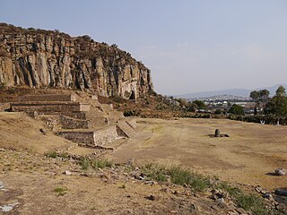
Cempoala or Zempoala is an important Mesoamerican archaeological site located in the Úrsulo Galván Municipality, in the state of Veracruz, Mexico. The site was inhabited mainly by Totonacs, Chinantecas and Zapotecs. It was one of the most important Totonac settlements during the postclassical Mesoamerican period and the capital of the kingdom of Totonacapan. It is located one kilometer from the shore of the Actopan River and six kilometres from the coast.
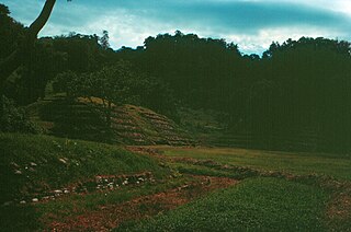
Cuyuxquihui is an archaeological site located in the Tecolutla valley of Veracruz, Mexico, in the region of the Totonac culture, about 22 kilometres (14 mi) southeast of El Tajín or 5 kilometres (3.1 mi) southeast of Paso de Correo.

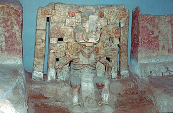
Classic Veracruz culture refers to a cultural area in the north and central areas of the present-day Mexican state of Veracruz, a culture that existed from roughly 100 to 1000 CE, or during the Classic era.
Balcón de Montezuma, also known as "Balcon del Chiue" is an archaeological site located at the Alta Cumbre ejido, some 18 kilometres (11.2 mi) south of Ciudad Victoria, in the state of Tamaulipas, México. It is situated about one kilometer north of Highway 101, towards San Luis Potosí.

Altavista, or Chalchihuites, is an archaeological site near the municipality of Chalchihuites in the Mexican state of Zacatecas, in the northwest of Mexico. It is believed that the site was a cultural oasis that was occupied more or less continuously from AD 100 to AD 1400.
El Cuajilote or Filobobos is an archeological site of the Totonac Culture, located in the Tlapacoyan municipality, Veracruz state, México.

El Cerrito is an archaeological zone in the central Mexican state of Querétaro. It is located in the municipality of Corregidora on the outskirts of the state capital, Santiago de Querétaro.
Huapalcalco is a pre-Columbian Mesoamerican archeological site located some 5 kilometers north of Tulancingo in the state of Hidalgo, Mexico.

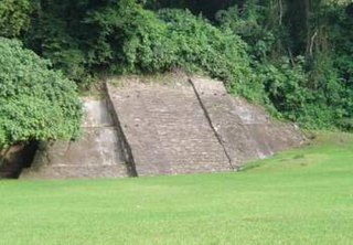
Huatusco is an archaeological site located in the Carrillo Puerto municipality, near the small, almost deserted town of Santiago Huatusco, on the northern bank of the Rio Atoyac in the Rancho El Fortin. The importance of the site due to the nearly undamaged pyramid from prehispanic times, the largest part of the actual temple is still standing, in the state of Veracruz, Mexico.

Ixtlán del Rio is an archaeological site located in the Ixtlán del Rio municipality, on the south west region of the Nayarit State, Mexico. It is also known as "Los Toriles" and contains the only vestiges of the western cultures in Nayarit.
Mesa de Cacahuatenco is a Mesoamerican pre-Columbian archeological site, located in the municipality of Ixhuatlán de Madero in northern Veracruz, Mexico, south of the Vinasca River.
La Joya is a Mesoamerican prehispanic archeological site, located in the municipality of Medellín in central Veracruz, Mexico, about 15 kilometers from the port of Veracruz, near the confluence of the Jamapa and Cotaxtla Rivers.

Las Choapas is a recently found archaeological site located within the municipality of Las Choapas, in the southeastern border of the Veracruz State, inside the San Miguel de Allende Ejido, bordering the municipalities of Huimanguillo, Tabasco and Ostuacán, in Chiapas.
The current municipality of Ignacio de la Llave, previously known as San Cristobal de la Llave, is placed in the popularly known region of La Mixtequilla, which is located in the western limit of the Papaloapan river, going through the Blanco, Limón and Las Pozas rivers. The climate of the region varie between hot-humid and tropical-humid, with frequent summer rains between July and September. The average temperature is from 64 and 72 °F, with a maximum registered in the high 70s °F (24-26°C) and the lowest in the high 40 °F (7-9°C). Ignacio de la Llave is neighbor and has deep political, social and trading relationships with: Alvarado, Acula, Ixmatlahuacan, Tlalixcoyan and Tierra Blanca.
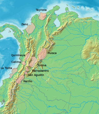
The San Agustín culture is one of the ancient Pre-Columbian cultures of Colombia. Its beginnings go back at least to the fourth millennium B.C. Several hundred large monolithic sculptures have been found here.
Comapa is a municipality in the Mexican state of Veracruz, located about 40 kilometres (25 mi) south of the state capital Xalapa.
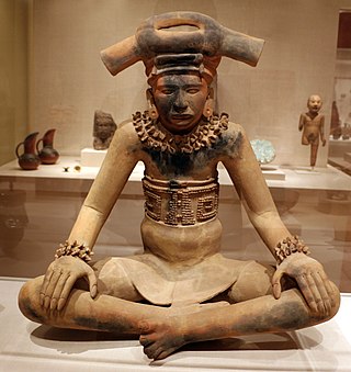
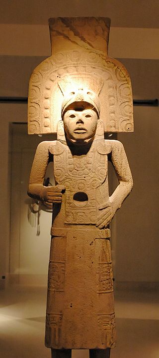
The Totonac culture or Totonec culture was a culture that existed among the indigenous Mesoamerican Totonac people who lived mainly in Veracruz and northern Puebla. Originally, they formed a confederation of cities, but, in later times, it seems that they were organized in three dominions: North, South and Serran. Its economy was agricultural and commercial. They had large urban centers such as: El Tajín (300–1200), which represents the height of the Totonac culture, Papantla (900–1519) and Cempoala (900–1519).