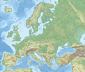
The Elbe Sandstone Mountains,[1] also called the Elbe Sandstone Highlands[2] (German: Elbsandsteingebirge, pronounced[ɛlpˈz̥antʃtaɪnɡəˌbɪʁɡə]; Czech: Děčinská vrchovina, pronounced[ˈɟɛtʃɪnskaːˈvr̩xovɪna]), are a mountain range straddling the border between the state of Saxony in southeastern Germany and the North Bohemian region of the Czech Republic, with about three-quarters of the area lying on the German side. In both countries, core parts of the mountain range have been declared a national park. The name derives from the sandstone which was carved by erosion. The river Elbe breaks through the mountain range in a steep and narrow valley.
The Saxon Switzerland and Bohemian Switzerland national parks, known also as Saxon-Bohemian Switzerland, are located within the territory of Elbe Sandstone Mountains.[3]
The Elbe valley in Bohemian Switzerland. The mountains on the horizon lie in Saxony
Terrain
The most striking characteristic of this deeply dissected rocky mountain range is the extraordinary variety of terrain within the smallest area. Unique amongst the Central European Uplands are the constant changes between plains, ravines, table mountains and rocky regions with undeveloped areas of forest. This diversity is ecologically significant. The variety of different locations, each with its own conditions in terms of soil and microclimate, has produced an enormous richness of species. The numbers of ferns and mosses alone is unmatched by any other of the German central uplands.
The occurrence of Elbe sandstones and hence the Elbe Sandstone Mountains themselves is related to widespread deposition by a former sea in the Upper Cretaceous epoch. On the Saxon side of the border the term "Elbe Valley Cretaceous" is used, referring to a region stretching from Meißen-Oberau in the northwest through Dresden and Pirna into Saxon Switzerland, and which is formed by sandstones, planers and other rocks as well as basal conglomerates of older origin. Several erosion relics from Reinhardtsgrimma through Dippoldiswalde and the Tharandt Forest to Siebenlehn form isolated examples south of Dresden. They are mainly characterised by sandstones. On the Bohemian side the sandstone beds continue and form part of the North Bohemian Cretaceous. The chalk sediments of the Zittau Basin are counted as part of the latter due to their regional-geological relationships. The sedimentary sequences of the Cretaceous sea continue across a wide area of the Czech Republic to Moravia. Together these beds form the Saxon-Bohemian Cretaceous Zone. In Czech geological circles, the Elbe Valley Cretaceous is described as the foothills of the Bohemian Cretaceous Basin.[3]
The eroded sandstone landscape of this region was formed from depositions that accumulated on the bottom of the sea millions of years ago. Large rivers carried sand and other eroded debris into the Cretaceous sea. Rough quartz sand, clay and fine marl sank and became lithified layer by layer. A compact sandstone sequence developed, about 20 x 30 kilometres wide and up to 600 metres thick dating to the lower Cenomanian to Santonianstages.[3] The tremendous variety of shapes in the sandstone landscape is a result of the subsequent chemical and physical erosion and biological processes acting on the rocks formed from those sands laid down during the Cretaceous Period.
The inlets of a Cretaceous sea, together with marine currents, carried away sand over a very long period of time into a shallow zone of the sea and then the diagenetic processes at differing pressure regimes resulted in the formation of sandstone beds. Its stratification is characterized by variations in the horizontal structure (deposits of clay minerals, grain sizes of quartz, differences in the grain-cement) as well as a typical but fairly small fossil presence and variably porous strata.
After the Cretaceous sea had retreated (marine regression), the surface of the land was shaped by weathering influences and watercourses, of which the Elbe made the deepest incision. Later the Lusatiangranodiorite was uplifted over the 600 metre thick sandstone slab along the Lusatian Fault and pushed it downwards until it fractured. This northern boundary of the sandstone deposit lies roughly along the line Pillnitz–Hohnstein–Hinterhermsdorf–Krásná Lípa.
At its southwestern edge the sandstone plate was uplifted by over 200 metres at the Karsdorf Fault, whereby the slab was tilted even more and increased the gradient of the Elbe River. The water masses cut valleys into the rock with their streambeds and contributed in places to the formation of the rock faces. Over time the gradients reduced, the streambed of the Elbe widened out and changed its course time and again, partly as a result of the climatic influences of the ice ages.
The mineral composition of the sandstone beds has a direct effect on the morphology of the terrain. The fine-grained form with clayey-silty cement between the quartz grains causes banks and slopes with terracing. The beds of sandstone with siliceous cement are typically the basis of the formation of rock faces and crags. Small variations in the cement composition of the rock can have a visible impact on the landscape.[4]
Elbe Sandstone gets its characteristic cuboid appearance from its thick horizontal strata (massive bedding) and its vertical fissures. In 1839 Bernhard Cotta wrote about this in his comments on the geognostic map: "Vertical fissures and cracks cut through, often virtually at right angles, the horizontal layers and, as a result, parallelepiped bodies are formed, that have given rise to the description Quader Sandstone.".[5]Quader is German for an ashlar or block of stone, hence the name "Square Sandstone" is also used in English.[6]
The term Quader Sandstone Mountains or Square Sandstone Mountains, introduced by Hanns Bruno Geinitz in 1849, is an historical, geological term for similar sandstone deposits, but was also used in connection with the Elbe Sandstone Mountains.[7][8]
The fissures were formed as a result of long-term tectonic stresses on the entire sandstone platform of the mountain range. This network of clefts runs through the sandstone beds in a relatively regular way, but in different directions in two regions of the range.[9] Subsequent weathering processes of very different forms and simultaneous complex deposition (leaching, frost and salt wedging, wind, solution weathering with sintering as well as biogenic and microbial effects) have further changed the nature of the rock surface. For example, collapse caves, small hole-like cavities (honeycomb weathering) with hourglass-shaped pillars, chimneys, crevices and mighty, rugged rock faces.
Many morphological formations in the rocky landscape of the Elbe Sandstone Mountains are suspected to have been formed as a consequence of karstification. Important indicators of such processes in the polygenetic and polymorphic erosion landscape of the Elbe Sandstone Mountains are the furrows with parallel ridges between them (grykes and clints) that look like cart ruts and which are particularly common, as well as extensive cave systems. They are occasionally described by the term pseudokarst. The application of the concept to several erosion formations in the sandstone of this mountain range is however contentious.[10][11][12][13][14] Czech geologists have identified in quartzite-cemented sandstone areas in the northern part of the Bohemian Cretaceous Basin, karst features in the shape of spherical caverns and cave formations. According to them, these emerged as a result of solution processes by water in complex interactions with iron compounds from neighbouring or intrusive magmatic-volcanic rocks. The variation in relief in these sandstone regions is explained on the basis of these processes.[15][16] The Elbe Sandstone Mountains are the greatest cretaceous sandstone erosion complex in Europe.[17]
Human-induced changes caused by nearly 1,000 years of continual sandstone quarrying have also contributed in parts of the sandstone highlands to the appearance of the landscape today. The fissures (called Loose by the quarrymen) played an important role here, because they provided in effect natural divisions in the rock that were helpful when demolishing a rock face or when dressing the rough blocks of stone.[18]
The sandstone of this region is a sought-after building material used for example, for imposing city edifices such as the Church of Our Lady in Dresden.
Conservation
Large parts of the Elbe Sandstone Mountains are under statutory protection. In Germany there is the national park region of Saxon Switzerland, which consists two elements: Saxon Switzerland National Park itself, founded in 1990 and covered an area of 93km²; and the protected area surrounding it that was founded in 1956 and covers 287km². The German part of the range was also designated in May 2006 as one of the 77 most important national geotopes in Germany by the Academy of Geosciences in Hanover.
In the Bohemian part of the range there has been a protected landscape area in the northeastern region since 1972 called the Elbe Sandstone Protected Landscape Area with an area of 324km². In 2000, Bohemian Switzerland National Park was established with an area of 79km², bringing around 700km² of the range under protection as a natural and cultural landscape.
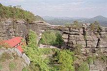
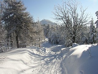
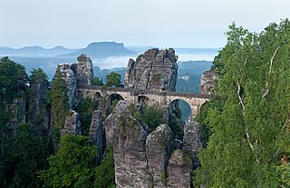
The Elbe Sandstone mountains have been a popular destination for tourists for more than 200 years, and for climbers for more than 100 years. It is also a popular recreation area for the nearby Saxon capital Dresden. Places of interest include the Bastei cliffs near Rathen, the Königstein Fortress, Pravčická brána, the Schrammsteine, Pfaffenstein, and the valleys of the Kirnitzsch and Kamenice rivers. There are some 14,000 climbing routes via which mountain climbers can conquer 1100 free-standing peaks. Visitors can experience the natural scenes on the asphalt Elbe cycle path, or on board a steam paddleboat that is part of the oldest fleet of its kind in the world.
The Elbe Sandstone Mountains have numerous facilities for cure and rehabilitation. The discovery of ferrous and sulphurous sources in Bad Schandau in 1730 led to its development as a health resort and the building of swimming baths.
The Ore Mountains lie along the Czech–German border, separating the historical regions of Bohemia in the Czech Republic and Saxony in Germany. The highest peaks are the Klínovec in the Czech Republic at 1,244 metres (4,081 ft) above sea level and the Fichtelberg in Germany at 1,215 metres (3,986 ft).
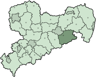
The Sächsische Schweiz is a former district (Kreis) in the south of Saxony, Germany. Neighboring districts were Weißeritzkreis, the district-free city Dresden and the districts Kamenz and Bautzen. To the south it borders the Czech Republic.
Saxon Switzerland is a hilly climbing area and national park in the Elbe Sandstone Mountains. It is located around the Elbe valley south-east of Dresden in Saxony, Germany, adjoining Bohemian Switzerland in the Czech Republic. Together with the Czech part, the region is known as Saxon-Bohemian Switzerland.
The Lusatian Mountains are a mountain range of the Western Sudetes on the southeastern border of Germany with the Czech Republic. They are a continuation of the Ore Mountains range west of the Elbe valley. The mountains of the northern, German, part are called the Zittau Mountains.
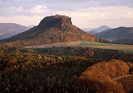
The Bastei is a rock formation rising 194 metres (636 ft) above the Elbe River in the Elbe Sandstone Mountains of Germany. Reaching a height of 305 metres (1,001 ft) above sea level, the jagged rocks of the Bastei were formed by water erosion over one million years ago. They are situated near Rathen, not far from Pirna southeast of the city of Dresden, and are the major landmark of the Saxon Switzerland National Park. They are also part of a climbing and hiking area that extends over the borders into the Bohemian Switzerland.
Bohemian Switzerland, also known as Czech Switzerland, is a nature region in the Elbe Sandstone Mountains in the northwestern Czech Republic, protected as a national park.
Saxon Switzerland National Park, is a national park in the German Free State of Saxony, near the Saxon capital Dresden. It covers two areas of 93.5 km2 (36.1 mi2) in the heart of the German part of the Elbe Sandstone Mountains, which is often called (the) Saxon Switzerland.
Reinhardtsdorf-Schöna is a municipality in the Sächsische Schweiz-Osterzgebirge district in the German federal state of Saxony. It has a population of approximately 1,600 and is located close to the Czech border in Saxon Switzerland, a popular tourist region.
The Saxon-Bohemian Chalk Sandstone Region is a natural region in south Saxony on the southern border with the Czech Republic.
The Zirkelstein is the smallest table hill of Saxon Switzerland, in Germany. It is a wooded, cone-shaped hill with a striking 40-metre-high (130 ft) summit block of sandstone rock.
The Eastern Ore Mountains form a natural region of Saxony that covers the eastern part of the Saxon Ore Mountains range. Together with the Western and Central Ore Mountains, it is part of the larger Saxon Highlands and Uplands region. Its southern continuation beyond the German border covers an area of roughly the same extent in the Czech Republic.
The Karsdorf Fault is a striking tectonic fracture line, which is part of the Central Saxon Fault, and is located in the eastern Ore Mountains and the Elbe Valley Slate Mountains of Germany. It forms the northern geological boundary of the Eastern Ore Mountains in the district of Sächsische Schweiz-Osterzgebirge with the Elbe zone, where it is adjoined by the Döhlen Basin and the Kreischa Basin.
The Pfaffenstein, formerly called the Jungfernstein, is a table hill, 434.6 m (1,426 ft) above sea level, in the Elbe Sandstone Mountains in Saxony. It lies west of the River Elbe near Königstein and is also referred to as "Saxon Switzerland in miniature" on account of its diverse structure.
The Cottaer Spitzberg is a 390.8 m high basalt dome on the western edge of Saxon Switzerland. Since 1979 the hill has been a protected area due to its geological and botanical features.
The Tisa Rocks or Tisa Walls are a group of rocks in the Czech Republic. It is located in the western Elbe Sandstone Mountains, not far from its topographical boundary with the Ore Mountains. The region, with its rock pillars up to 30 m high, is one of the major tourist attractions of the region. The Tisa Rocks and the neighbouring Bürschlické Rocks are protected as a nature monument.
The Lusatian Fault, formerly Lusatian Overthrust, is the most important geological disturbance zone between the Elbe valley and the Giant Mountains. It is a fault that separates the granite of Lusatia from the Cretaceous sandstones of North Bohemia to the south. It is assumed that there was a fault throw of several hundred metres whereby the northern block was uplifted or upthrust relative to the southern block.
Elbe Sandstone describes sandstones that naturally occur in North Bohemia and those parts of Saxony within the area around Dresden. It is named after the River Elbe, which cuts through the sandstone region in a transverse valley, the Elbe Valley Zone. It reaches the surface most strikingly in the Elbe Sandstone Mountains, which are divided into the regions of Saxon Switzerland on German soil and Bohemian Switzerland on Czech territory. The term Elbe Sandstone is used in both geological and economic contexts.
Cotta Sandstone is found in the Elbe Valley and in its numerous tributary valleys. Its main deposit lies in the west of the Elbe Sandstone Mountains, where it runs up to the Bohemian border, ending south of Pirna. It is named after the village of Cotta in the borough of Dohma, an area where the stone is quarried.
The Schwedenlöcher is a gorge-like side valley of the Amselgrund near Rathen in Saxon Switzerland.
The Euroregion Elbe/Labe is one of the Euroregions with German and Czech participation. The purpose of the community of municipal interests is cross-border cooperation on a supranational level. The term is used to refer to both the organization and the geographical area of its operation.
↑ W. Pälchen (Hrsg.)/ H. Walter (publ.): Geologie von Sachsen. Geologischer Bau und Entwicklungsgeschichte. Schweizerbart'sche Verlagsbuchhandlung, Stuttgart 2008, p. 340–341, ISBN978-3-510-65239-6.
↑ Bernhard Cotta: Erläuterungen zu Section VI der geognostischen Charte des Königreiches Sachsen und der angrenzenden Länderabtheilungen, oder: Geognostische Skizze der Gegend zwischen Neustadt, Bischoffswerda, Wittichenau, Rothenburg, Görlitz, Ostritz, Rumburg und Schluckenau. Arnoldische Buchhandlung, Dresden und Leipzig, 1839, p. 49–50.
↑ Hanns Bruno Geinitz: Das Quadergebirge oder die Kreideformation in Sachsen, mit besonderer Berücksichtigung der glaukonitreichen Schichten, Fürstlich Jablonowski'sche Gesellschaft zu Leipzig, 1850. Digitalisat
↑ Notiz 10 February 1850 by Bernhard Cotta. In: K. C. von Leonhard, H. G. Bronn (Hrsg.): Neues Jahrbuch für Mineralogie, Geognosie, Geologie und Petrefakten-Kunde. Stuttgart, Jg. 1850, p. 190 digitalised version
↑ Dieter Kutschke: Steinbrüche und Steinbrecher in der Sächsischen Schweiz. (Schriftenreihe des Stadtmuseums Pirna, Heft 11) Stadtmuseum Pirna, Pirna 2000. p. 4–5, 32.
This page is based on this Wikipedia article Text is available under the CC BY-SA 4.0 license; additional terms may apply. Images, videos and audio are available under their respective licenses.