Related Research Articles
Esri is an international supplier of geographic information system (GIS) software, web GIS and geodatabase management applications. The company is headquartered in Redlands, California.
The EASTInitiative is an educational non-profit that oversees and trains for a school program, EAST, that operates primarily in the United States.
A GIS software program is a computer program to support the use of a geographic information system, providing the ability to create, store, manage, query, analyze, and visualize geographic data, that is, data representing phenomena for which location is important. The GIS software industry encompasses a broad range of commercial and open-source products that provide some or all of these capabilities within various information technology architectures.
ArcSDE is a server-software sub-system that aims to enable the usage of Relational Database Management Systems for spatial data. The spatial data may then be used as part of a geodatabase.
ArcGIS is a family of client software, server software, and online geographic information system (GIS) services developed and maintained by Esri. ArcGIS was first released in 1999 and originally was released as ARC/INFO, a command line based GIS system for manipulating data. ARC/INFO was later merged into ArcGIS Desktop, which was eventually superseded by ArcGIS Pro in 2015. ArcGIS Pro works in 2D and 3D for cartography and visualization, and includes artificial Intelligence (AI).

Java Unified Mapping Program (JUMP) is a Java based vector and raster GIS and programming framework. Current development continues under the OpenJUMP name.
GeoSTAC is a set of spatial data and tools accessed through a Geographic Information System.
GIS Day is an annual event celebrating the technology of geographic information systems (GIS) that was initiated by spatial analytics world-leader Esri, and which first took place in 1999. Esri president and co-founder Jack Dangermond credits Ralph Nader with being the person who inspired the creation of GIS Day. He considered the event a good initiative for people to learn about geography and the many uses of GIS. He wanted GIS Day to be a grassroots effort and open to everyone to participate.
Geospatial metadata is a type of metadata applicable to geographic data and information. Such objects may be stored in a geographic information system (GIS) or may simply be documents, data-sets, images or other objects, services, or related items that exist in some other native environment but whose features may be appropriate to describe in a (geographic) metadata catalog.
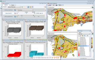
CommunityViz is the name of a group of extensions to ArcGIS Geographic Information System software. CommunityViz is an analysis tool used for, among other applications, urban planning, land use planning, geodesign, transportation planning and resource management applications. It also provides options for 3D visualization in the Scenario 3D and Scenario 360 plugins. CommunityViz also allows users to export and view their work in ArcGIS Online, Google Earth and other KML/KMZ viewers such as ArcGIS Explorer. The software was originally produced by the Orton Family Foundation and in 2005 was handed off to Placeways LLC. In 2017, the software was purchased by City Explained, Inc. where its development continues.
ArcMap is the main component of Esri's ArcGIS suite of geospatial processing programs, and is used primarily to view, edit, create, and analyze geospatial data. ArcMap allows the user to explore data within a data set, symbolize features accordingly, and create maps. This is done through two distinct sections of the program, the table of contents and the data frame. In October 2020, it was announced that there are no plans to release 10.9 in 2021, and that ArcMap would no longer be supported after March 1, 2026. Esri are encouraging their users to transition to ArcGIS Pro.
The Conservation Geoportal was an online geoportal, intended to provide a comprehensive listing of geographic information systems (GIS) datasets and web map service relevant to biodiversity conservation. It is currently defunct. The site, its contents and functionality were free for anyone to use and contribute to. The Conservation Geoportal was launched on June 28, 2006 at the joint Society for Conservation Biology and Society for Conservation GIS Conference in San Jose, California, USA. As of October 2007, it included metadata for over 3,667 GIS records.
The Barrow Area Information Database (BAID) is designed to support Arctic science with a special focus on the research hubs of Barrow, Atqasuk and Ivotuk on the North Slope of Alaska.
Produced by the Environmental Systems Research Institute, the Esri International User Conference is the world's largest event dedicated to geographic information system (GIS) technology. It is held annually in the United States, usually for one week in July at the San Diego Convention Center in San Diego, California. The Esri UC dates back to 1981. In 2008, conference attendance grew to more than 14,000 attendees.
Geodesign is a set of concepts and methods used to involve all stakeholders and various professions in collaboratively designing and realizing the optimal solution for spatial challenges in the built and natural environments, utilizing all available techniques and data in an integrated process. Originally, geodesign was mainly applied during the design and planning phase. "Geodesign is a design and planning method which tightly couples the creation of design proposals with impact simulations informed by geographic contexts." Now, it is also used during realization and maintenance phases and to facilitate re-use of for example buildings or industrial areas. Geodesign includes project conceptualization, analysis, design specification, stakeholder participation and collaboration, design creation, simulation, and evaluation.

ArcGIS CityEngine is a commercial three-dimensional (3D) modeling program developed by Esri R&D Center Zurich and specialises in the generation of 3D urban environments. Using a procedural modeling approach, it supports the creation of detailed large-scale 3D city models. CityEngine works with architectural object placement and arrangement in the same manner that software like VUE manages terrain, ecosystems and atmosphere mapping. Unlike the traditional 3D modeling methodology which uses Computer-Aided Design (CAD) tools and techniques, CityEngine takes a different approach to shape generation via a rule-based system. It can also use Geographic Information System (GIS) datasets due to its integration with the wider Esri/ArcGIS platform. Due to this unique feature set, CityEngine has been used in academic research and built environment professions, e.g., urban planning, architecture, visualization, game development, entertainment, archeology, military and cultural heritage. CityEngine can be used within Building Information Model (BIM) workflows as well as visualizing the data of buildings in a larger urban context, enhancing its working scenario toward real construction projects.
Geographic information systems (GIS) play a constantly evolving role in geospatial intelligence (GEOINT) and United States national security. These technologies allow a user to efficiently manage, analyze, and produce geospatial data, to combine GEOINT with other forms of intelligence collection, and to perform highly developed analysis and visual production of geospatial data. Therefore, GIS produces up-to-date and more reliable GEOINT to reduce uncertainty for a decisionmaker. Since GIS programs are Web-enabled, a user can constantly work with a decision maker to solve their GEOINT and national security related problems from anywhere in the world. There are many types of GIS software used in GEOINT and national security, such as Google Earth, ERDAS IMAGINE, GeoNetwork opensource, and Esri ArcGIS.
Esri Canada is the Canadian provider of enterprise geographic information system (GIS) solutions from Esri. GIS allows multiple layers of information to be displayed on a single map. Esri Canada’s solutions are based on ArcGIS technology. The company also distributes vertical-focused solutions. from technology partners such as Schneider Electric. A third of its offerings are professional services.
GeoTime is geospatial analysis software that allows the visual analysis of events over time. It adds time as the third dimension to a two-dimensional map, allowing users to see changes within time series data. Users can view real-time animated playback of data and use automated analysis tools within the software to identify location patterns, connections between events, and trends.

Joseph Kerski is a geographer with a focus on the use of Geographic Information Systems (GIS) in education.
References
- ↑ GeoMentor Program.
- ↑ GIS Educational Community Gathers in San Diego. ArcUser – October/December 2004.
- ↑ Learning, Sharing, and Relaxing at EdUC. ArcUser – October/December 2005.
- ↑ 2006 Esri Education User Conference. ArcNews – Fall 2006.
- ↑ 4-H and GIS – A Combination to Spark Imaginations. ArcNews – Fall 2006.
- ↑ Seventh Annual Esri Education User Conference in Review. ArcUser – July/September 2007.
- ↑ Esri's Education Community Web Site Focal Point for GIS Educators. ArcNews: Spring 2009.
- ↑ The 2008 ESRI UC Ushers in ArcGIS 9.3 and Connects Attendees. ArcNews: Fall 2008.
- ↑ 2009 Esri Education User Conference. ArcNews: Winter 2008/2009.
- ↑ Making a Difference in Geo-Literacy. ArcNews: Fall 2009.