Etna, Maine

Last updated

Etna, Maine
USA Maine location map.svg
Red pog.svg
Etna, Maine
Location within the state of Maine
Coordinates: 44°47′14″N69°7′59″W / 44.78722°N 69.13306°W / 44.78722; -69.13306
Country United States
State Maine
County Penobscot
Area
[1]
  Total24.97 sq mi (64.67 km2)
  Land24.81 sq mi (64.26 km2)
  Water0.16 sq mi (0.41 km2)
Elevation
505 ft (154 m)
Population
 (2020)
  Total1,226
  Density49/sq mi (19.1/km2)
Time zone UTC-5 (Eastern (EST))
  Summer (DST) UTC-4 (EDT)
ZIP code
04434
Area code 207
FIPS code 23-23865
GNIS feature ID0582468

Etna is a town in Penobscot County, Maine, United States. The population was 1,226 at the 2020 census. [2]

Contents

History

Etna is named for the famed Mount Etna in Italy. It was originally known as "Crosbytown" after its first proprietor, Gen. John Crosby of Hampden. Etna was incorporated as a town in 1820. [3] c.1850 it had a population of 802. [4]

Camp Etna Gladys LaLiberte Memorial Temple.jpg

Camp Etna is a summer colony where spiritualists have held yearly meetings since 1876, when Daniel Buswell, Jr., held the first meeting in a tent. A temple seating 1,100, a club house, and 78 cottages were built in 1880. The grave of Mrs. Mary Scannell Pepper Vanderbilt, a leader and benefactor of the camp, is marked by a monument. [5]

Geography

According to the United States Census Bureau, the town has a total area of 24.97 square miles (64.67 km2), of which 24.81 square miles (64.26 km2) is land and 0.16 square miles (0.41 km2) is water. [1]

Demographics

Historical population
CensusPop.Note
1820 194
1830 36286.6%
1840 745105.8%
1850 8027.7%
1860 8495.9%
1870 844−0.6%
1880 8956.0%
1890 646−27.8%
1900 527−18.4%
1910 523−0.8%
1920 386−26.2%
1930 4188.3%
1940 46010.0%
1950 458−0.4%
1960 4866.1%
1970 5268.2%
1980 75844.1%
1990 97728.9%
2000 1,0123.6%
2010 1,24623.1%
2020 1,226−1.6%
U.S. Decennial Census [6]

2010 census

As of the census [7] of 2010, there were 1,246 people, 481 households, and 338 families living in the town. The population density was 50.2 inhabitants per square mile (19.4/km2). There were 559 housing units at an average density of 22.5 per square mile (8.7/km2). The racial makeup of the town was 97.2% White, 0.7% African American, 0.6% Native American, 0.4% Asian, 0.3% from other races, and 0.7% from two or more races. Hispanic or Latino of any race were 1.1% of the population.

There were 481 households, of which 35.1% had children under the age of 18 living with them, 56.5% were married couples living together, 8.7% had a female householder with no husband present, 5.0% had a male householder with no wife present, and 29.7% were non-families. 20.2% of all households were made up of individuals, and 6.8% had someone living alone who was 65 years of age or older. The average household size was 2.59 and the average family size was 2.94.

The median age in the town was 39.1 years. 23.9% of residents were under the age of 18; 6.7% were between the ages of 18 and 24; 27.5% were from 25 to 44; 31.4% were from 45 to 64; and 10.6% were 65 years of age or older. The gender makeup of the town was 50.7% male and 49.3% female.

2000 census

As of the census [8] of 2000, there were 1,012 people, 392 households, and 295 families living in the town. The population density was 41.4 inhabitants per square mile (16.0/km2). There were 427 housing units at an average density of 17.5 per square mile (6.8/km2). The racial makeup of the town was 99.11% White, 0.20% African American, 0.20% Native American, 0.30% Asian, and 0.20% from two or more races. Hispanic or Latino of any race were 0.10% of the population.

There were 392 households, out of which 32.1% had children under the age of 18 living with them, 61.2% were married couples living together, 8.2% had a female householder with no husband present, and 24.7% were non-families. 17.6% of all households were made up of individuals, and 6.6% had someone living alone who was 65 years of age or older. The average household size was 2.58 and the average family size was 2.89.

In the town, the population was spread out, with 24.3% under the age of 18, 7.9% from 18 to 24, 31.6% from 25 to 44, 26.2% from 45 to 64, and 10.0% who were 65 years of age or older. The median age was 37 years. For every 100 females, there were 92.8 males. For every 100 females age 18 and over, there were 94.4 males.

The median income for a household in the town was $33,681, and the median income for a family was $37,750. Males had a median income of $30,057 versus $21,250 for females. The per capita income for the town was $14,633. About 13.5% of families and 18.1% of the population were below the poverty line, including 26.7% of those under age 18 and 14.9% of those age 65 or over.

Notable person

Related Research Articles

<span class="mw-page-title-main">Mount Etna, Indiana</span> Town in Indiana, United States

Mount Etna is a town in Huntington County, Indiana, United States. The population was 94 at the 2010 census. It lies at the intersection of four townships: Jefferson, Lancaster, Polk and Wayne.

<span class="mw-page-title-main">Etna Green, Indiana</span> Town in Indiana, United States

Etna Green is a town in Etna Township, Kosciusko County, in the U.S. state of Indiana. The population was 586 at the 2010 census.

<span class="mw-page-title-main">Eagle Lake, Maine</span> Town in the state of Maine, United States

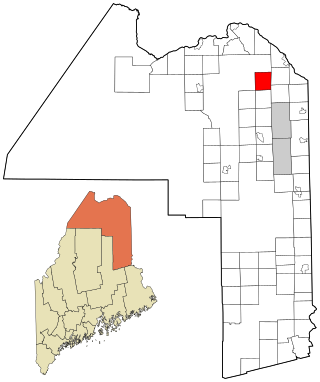
Eagle Lake is a town in Aroostook County, Maine, United States. The population was 772 at the 2020 census. The town was named by a body of troops heading from Bangor to the Aroostook War for the many eagles that they saw around the lake. A total of 49.0% of the population speaks French, reflecting a trend in Northeastern Maine.

<span class="mw-page-title-main">St. Francis, Maine</span> Town in the state of Maine, United States

St. Francis is a town in Aroostook County, Maine, United States on the Canada–United States border at the junction of the St. Francis River and the Saint John River. The population was 438 at the 2020 census. First settled by English speakers from southern Maine, the original population has been supplanted by French-speaking Acadians.

<span class="mw-page-title-main">Stockholm, Maine</span> Town in the state of Maine, United States

Stockholm is a town in Aroostook County, Maine, United States. The population was 250 at the 2020 census.

<span class="mw-page-title-main">Chesterville, Maine</span> Town in Maine, United States

Chesterville is a town in Franklin County, Maine, United States. The population was 1,328 at the 2020 census.

<span class="mw-page-title-main">Penobscot, Maine</span> Town in the state of Maine, United States

Penobscot is a town in Hancock County, Maine, United States. The Bagaduce River flows through the town. The population was 1,136 at the 2020 census.

<span class="mw-page-title-main">Trenton, Maine</span> Town in the state of Maine, United States

Trenton is a town in Hancock County, Maine, United States, near Acadia National Park. The population was 1,584 at the 2020 census. Hancock County-Bar Harbor Airport is located in Trenton.

<span class="mw-page-title-main">Manchester, Maine</span> Town in Maine, United States

Manchester is a town in Kennebec County, Maine, United States, located at 44.33°N 69.87°W. The population was 2,456 at the 2020 census. The southern part of the town bordering Cobbosseecontee Lake is a popular recreation spot in central Maine, and part of the Winthrop Lakes Region. Manchester is included in the Augusta, Maine micropolitan and included in the Lewiston-Auburn, Maine metropolitan New England City and Town Area.

<span class="mw-page-title-main">Hartford, Maine</span> Town in the state of Maine, United States

Hartford is a town in Oxford County, Maine, United States. Hartford is included in the Lewiston-Auburn, Maine metropolitan New England City and Town Area. The population was 1,203 at the 2020 census.

Stoneham is a town in Oxford County, Maine, United States. The population was 261 at the 2020 census.

<span class="mw-page-title-main">Stow, Maine</span> Town in the state of Maine, United States

Stow is a town in Oxford County, Maine, United States. The population was 393 at the 2020 census.

<span class="mw-page-title-main">Upton, Maine</span> Town in the state of Maine, United States

Upton is a town in Oxford County, Maine, United States. The population was 69 at the 2020 census.

<span class="mw-page-title-main">Abbot, Maine</span> Town in the state of Maine, United States

Abbot is a town in Piscataquis County, Maine, United States. The population was 650 at the 2020 census. It was named for the treasurer of Bowdoin College, John Abbot.

Detroit is a town in Somerset County, Maine, United States. The population was 885 at the 2020 census.

<span class="mw-page-title-main">Smithfield, Maine</span> Town in the state of Maine, United States

Smithfield is a town in Somerset County, Maine, United States. The population was 925 at the 2020 census. The town was incorporated on February 29, 1840, making it the only town in Maine incorporated on Leap Day. The town was named after the Rev. Henry Smith, an early settler.

<span class="mw-page-title-main">Burnham, Maine</span> Town in the state of Maine, United States

Burnham is a town in Waldo County, Maine, United States. The population was 1,096 at the 2020 census.

Beddington is a town in Washington County, Maine, United States. The population was 60 at the 2020 census. It is the third-smallest organized town in Maine after Frye Island and Frenchboro.

Deblois is a town in Washington County, Maine, United States. The town was named after T.A. Deblois, president of the Bank of Portland. The population was 74 at the 2020 census.

<span class="mw-page-title-main">Winter, Wisconsin</span> Village in Wisconsin, United States

Winter is a village in Sawyer County, Wisconsin, United States. The population was 233 at the 2010 census. The village is within the Town of Winter.

References

  1. 1 2 "US Gazetteer files 2010". United States Census Bureau . Retrieved December 16, 2012.
  2. "Census - Geography Profile: Etna town, Penobscot County, Maine". United States Census Bureau . Retrieved January 21, 2022.
  3. Varney, George (1881). A Gazetteer of the State of Maine. Boston: BB Russell. p.  223 . Retrieved January 15, 2016.
  4. Baldwin, Thomas; J, Thomas (1854). A New and Complete Gazetteer of the United States. Philadelphia: Lippincott Grambo & Co. pp.  365–366.
  5. Federal Writer's Project of the WPA for Maine, Maine: A Guide Downeast (Washington:1937), p. 299; Cadwallader, M. E. Mary S. Vanderbilt: A Twentieth Century Seer. Progressive Thinker Publishing House: Chicago, 1921. Pages 104-117
  6. "Census of Population and Housing". Census.gov. Retrieved June 4, 2015.
  7. "U.S. Census website". United States Census Bureau . Retrieved December 16, 2012.
  8. "U.S. Census website". United States Census Bureau . Retrieved January 31, 2008.

44°49′15″N69°06′40″W / 44.82083°N 69.11111°W / 44.82083; -69.11111