Eunice, Louisiana

Last updated

Eunice, Louisiana
City of Eunice
Motto: 
"Louisiana's Prairie Cajun Capital" [1]
St. Landry Parish Louisiana Incorporated and Unincorporated areas Eunice Highlighted.svg
Location of Eunice in St. Landry Parish, Louisiana.
USA Louisiana location map.svg
Red pog.svg
Eunice, Louisiana
Usa edcp location map.svg
Red pog.svg
Eunice, Louisiana
Coordinates: 30°29′37″N92°25′01″W / 30.49361°N 92.41694°W / 30.49361; -92.41694
CountryUnited States
StateLouisiana
Parishes Acadia, St. Landry
Chartered (village)September 12, 1894
Incorporated (town)June 4, 1895
Founded by C.C. Duson
Named for Eunice Pharr Duson, wife of C.C. Duson
Government
  MayorScott A. Fontenot (No Party)
  Chief of PoliceKyle LeBouef (R)
Area
[2]
  Total5.14 sq mi (13.31 km2)
  Land5.14 sq mi (13.31 km2)
  Water0.00 sq mi (0.00 km2)
Elevation
49 ft (15 m)
Population
 (2020)
  Total9,422
  Density1,833.79/sq mi (708.09/km2)
Time zone UTC-6 (CST)
  Summer (DST) UTC-5 (CDT)
ZIP code
70535
Area code 337
FIPS code 22-24565
Website Eunice, Louisiana

Eunice is a city in Acadia and St. Landry parishes in the U.S. state of Louisiana. The 2010 census placed the population at 10,398, a decrease of 1,101, or 9.5 percent, from the 2000 tabulation of 11,499.

Contents

The St. Landry Parish portion of Eunice is part of the Opelousas Eunice Micropolitan Statistical Area, while the Acadia Parish portion is part of the Crowley Micropolitan Statistical Area.

History

Statue of Eunice Pharr Duson EunicePharrDuson.jpg
Statue of Eunice Pharr Duson

One-time lawman and pioneer land developer C.C. Duson is credited with founding Eunice, which was named for his second wife, Eunice Pharr Duson. He and his brother, W.W. Duson, had already founded Crowley, Louisiana in 1887, and he looked to the north of the parish for future development. Duson bought 160 acres (0.65 km2) of land from Willie Humble of Prairie Faquetaïque and mapped out a town site, laid out in lots 50-by-140 feet, 12 lots to the block. Next, he persuaded the Southern Pacific Railroad to extend a branch line from Crowley to his new town. Then he began what he and his brother had learned how to do as well as anyone: promote land sales. It was chartered as a village on September 12, 1894, and incorporated as a town on June 4, 1895. [3]

Evangeline Parish was created with the passage of a bill in June 1908. Eunice and Ville Platte were in competition for the parish seat, and Ville Platte was selected by voters on April 12, 1909. After the election, Eunice declared it would remain in St. Landry Parish. [4]

In May 2000 a chemical freight train derailed in Eunice, spilling numerous hazardous chemicals and causing about 15 tank cars to explode and burn; approximately 3,500 residents of the town were evacuated for as many as five days. Over 10,000 residents settled in May 2004 for $65 million with the Union Pacific Corporation in a class action suit, claiming that the corporation had failed to repair a defective section of track. [5] [6]

Geography

According to the United States Census Bureau, the city has a total area of 4.7 square miles (12.1 km2), all land.

Louisiana Highway 13 and U.S. Highway 190 pass through the center of Eunice with U.S. 190 heading west 26 miles (42 km) to Kinder and east 21 miles (34 km) to Opelousas, the seat of St. Landry Parish. LA-13 heads north 11 miles (18 km) to Mamou and south 20 miles (32 km) to Crowley, the seat of Acadia Parish.

Climate

The climate in this area is characterized by hot, humid summers and generally mild to cool winters. According to the Köppen Climate Classification system, Eunice has a humid subtropical climate, abbreviated "Cfa" on climate maps. [7]

Climate data for Eunice, Louisiana (1991–2020 normals, extremes 1982–2015)
MonthJanFebMarAprMayJunJulAugSepOctNovDecYear
Record high °F (°C)84
(29)
83
(28)
88
(31)
94
(34)
101
(38)
103
(39)
104
(40)
107
(42)
109
(43)
98
(37)
89
(32)
84
(29)
109
(43)
Mean daily maximum °F (°C)59.9
(15.5)
64.2
(17.9)
71.2
(21.8)
77.6
(25.3)
84.7
(29.3)
90.2
(32.3)
92.0
(33.3)
93.0
(33.9)
88.9
(31.6)
80.7
(27.1)
70.0
(21.1)
62.5
(16.9)
77.9
(25.5)
Daily mean °F (°C)49.9
(9.9)
54.2
(12.3)
60.9
(16.1)
67.2
(19.6)
75.2
(24.0)
80.8
(27.1)
82.6
(28.1)
82.9
(28.3)
78.4
(25.8)
69.0
(20.6)
59.2
(15.1)
52.2
(11.2)
67.7
(19.8)
Mean daily minimum °F (°C)39.8
(4.3)
44.2
(6.8)
50.6
(10.3)
56.9
(13.8)
65.6
(18.7)
71.3
(21.8)
73.2
(22.9)
72.8
(22.7)
67.8
(19.9)
57.2
(14.0)
48.4
(9.1)
41.9
(5.5)
57.5
(14.2)
Record low °F (°C)14
(−10)
15
(−9)
23
(−5)
34
(1)
41
(5)
53
(12)
62
(17)
58
(14)
44
(7)
30
(−1)
25
(−4)
9
(−13)
9
(−13)
Average precipitation inches (mm)6.43
(163)
4.62
(117)
3.91
(99)
4.62
(117)
5.69
(145)
4.84
(123)
4.61
(117)
4.24
(108)
4.90
(124)
4.86
(123)
4.43
(113)
4.79
(122)
57.94
(1,472)
Average snowfall inches (cm)0.0
(0.0)
0.0
(0.0)
0.0
(0.0)
0.0
(0.0)
0.0
(0.0)
0.0
(0.0)
0.0
(0.0)
0.0
(0.0)
0.0
(0.0)
0.0
(0.0)
0.0
(0.0)
0.0
(0.0)
0.0
(0.0)
Average precipitation days (≥ 0.01 in)10.18.77.96.86.810.710.68.97.06.37.59.0100.3
Average snowy days (≥ 0.1 in)0.00.00.00.00.00.00.00.00.00.00.00.00.0
Source: NOAA [8] [9]

Parish

Eunice is in parts of three parishes, St. Landry, Acadia and Evangeline. Thus, the names of certain businesses in Eunice, such as Tri-Parish Bank. Most of the Evangeline Parish portion of Eunice is unincorporated.

St. Landry

Most of the city limits are located in St. Landry parish. This was one of the original parishes in Louisiana.

Acadia Parish

Acadia to the south actually borders most of the southern city limits, in a close west to east parallel line, with Sittig Street in the center, parish road 7-23 to the east, and both just inside the St. Landry Parish. On the west side the city limits drops south following highway 755 south and includes the airport, the Louisiana State University Eunice campus, as well as the streets around the campus. Acadia Parish also succeeded from the parish of St. Landry. [10]

Demographics

Historical population
CensusPop.Note
1900 316
1910 1,684432.9%
1920 3,27294.3%
1930 3,5979.9%
1940 5,24245.7%
1950 8,18456.1%
1960 11,32638.4%
1970 11,3900.6%
1980 12,4799.6%
1990 11,162−10.6%
2000 11,4993.0%
2010 10,398−9.6%
2020 9,422−9.4%
U.S. Decennial Census [11]
Eunice racial composition [12]
RaceNumberPercentage
White (non-Hispanic)5,44857.82%
Black or African American (non-Hispanic)3,28934.91%
Native American 120.13%
Asian 890.94%
Other/Mixed 3123.31%
Hispanic or Latino 2722.89%

As of the 2020 United States census, there were 9,422 people, 3,642 households, and 2,470 families residing in the city. As of the 2010 United States Census, there were 10,398 people living in the city. The racial makeup of the city was 63.0% White, 32.5% Black, 0.3% Native American, 0.6% Asian, 0.2% from some other race and 1.2% from two or more races. 2.3% were Hispanic or Latino of any race.

As of the census [13] of 2000, there were 11,499 people, 4,316 households, and 2,986 families living in the city. The population density was 2,459.6 inhabitants per square mile (949.7/km2). There were 4,675 housing units at an average density of 1,000.0 per square mile (386.1/km2). The racial makeup of the city was 68.76% White, 29.91% African American, 0.11% Native American, 0.21% Asian, 0.02% Pacific Islander, 0.34% from other races, and 0.65% from two or more races. Hispanic or Latino of any race were 1.11% of the population.

There were 4,316 households, out of which 34.8% had children under the age of 18 living with them, 47.0% were married couples living together, 17.5% had a female householder with no husband present, and 30.8% were non-families. 27.4% of all households were made up of individuals, and 12.3% had someone living alone who was 65 years of age or older. The average household size was 2.59 and the average family size was 3.18.

In the city, the population was spread out, with 29.6% under the age of 18, 10.0% from 18 to 24, 24.1% from 25 to 44, 20.8% from 45 to 64, and 15.5% who were 65 years of age or older. The median age was 35 years, a half year older than the statewide median age of 34.0 years. For every 100 females, there were 89.0 males. For every 100 females age 18 and over, there were 82.5 males.

The median income for a household in the city was $21,372, and the median income for a family was $27,173. Males had a median income of $29,500 versus $18,912 for females. The per capita income for the city was $11,937. About 26.5% of families and 31.4% of the population were below the poverty line, including 41.9% of those under age 18 and 20.6% of those age 65 or over.

Arts and culture

Located near the heart of Cajun country, Eunice is famous for its Cajun music, and in November 1997 the Cajun Music Hall of Fame and Museum was founded there. [14] The City of Eunice and the National Park Service sponsor "Laissez les bons temps rouler au rendezvous des cajuns", a live Cajun music show every Saturday night at the Liberty Theatre, an old movie theater that was restored by a "coup de main" by local volunteers after falling into disrepair. [15]

Eunice is home to the Prairie Acadian Cultural Center, a unit of Jean Lafitte National Historical Park and Preserve. [16]

Eunice is host to one of the largest Courir de Mardi Gras (traditional rural French Louisiana Mardi Gras observance,) [17] as well as the World Championship Crawfish Étouffée Cook-off.

In 2015, The Eunice Rotary Club and the Jean Lafitte National Park and Preserve teamed up to host a revitalized folklife festival known as the Experience Louisiana Festival [18] held each October on the campus of LSU Eunice.

Education

Eunice is the home of Louisiana State University Eunice, a community college. LSUE is a campus of Louisiana State University.

Eunice is also home to both Eunice High School and St Edmund High School.

Notable people

See also

Related Research Articles

<span class="mw-page-title-main">St. Martin Parish, Louisiana</span> Parish in Louisiana, United States

St. Martin Parish is a parish located in the U.S. state of Louisiana, founded in 1811. Its parish seat is St. Martinville, and the largest city is Breaux Bridge. At the 2020 census, the population was 51,767. St. Martin Parish is part of the Lafayette metropolitan area in the region of Acadiana, along the Gulf Coast.

<span class="mw-page-title-main">St. Landry Parish, Louisiana</span> Parish in Louisiana, United States

St. Landry Parish is a parish located in the U.S. state of Louisiana. As of the 2020 Census, the population was 82,540. The parish seat is Opelousas. The parish was established in 1807.

<span class="mw-page-title-main">Evangeline Parish, Louisiana</span> Parish in Louisiana, United States

Evangeline Parish is a parish located in the U.S. state of Louisiana. As of the 2020 census, the population was 32,350. The parish seat is Ville Platte.

<span class="mw-page-title-main">Allen Parish, Louisiana</span> Parish in Louisiana, United States

Allen Parish is a parish located in the U.S. state of Louisiana. As of the 2020 census, the population was 22,750. The parish seat is Oberlin and the largest city is Oakdale. Allen Parish is in southwestern Louisiana, southwest of Alexandria.

<span class="mw-page-title-main">Acadia Parish, Louisiana</span> Parish in Louisiana, United States

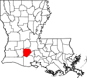
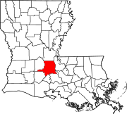
Acadia Parish is a parish located in the U.S. state of Louisiana. At the 2020 U.S. census, the population was 57,576. The parish seat is Crowley. The parish was founded from parts of St. Landry Parish in 1886, and later an election was held to determine the parish seat, ending when Crowley beat Rayne and Prairie Hayes. Acadia Parish is included in the Lafayette metropolitan statistical area.

<span class="mw-page-title-main">Church Point, Louisiana</span> Town in Louisiana, United States

Church Point is a town in Acadia Parish, Louisiana, United States. The population was 4,560 at the 2010 census. It is part of the Crowley Micropolitan Statistical Area. Church Point is known as the Buggy Capital of the World as it used to be host to the annual Buggy Festival which has since gone defunct.

<span class="mw-page-title-main">Crowley, Louisiana</span> City in Louisiana, United States

Crowley is a city in, and the parish seat of, Acadia Parish in the U.S. state of Louisiana. At the 2020 United States census, Crowley had a population of 11,710. Crowley is the principal city of the Crowley micropolitan statistical area, which includes all of Acadia Parish. It is also part of the larger Lafayette–Acadiana combined statistical area.

<span class="mw-page-title-main">Iota, Louisiana</span> Town in Louisiana, United States

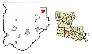
Iota is a town in Acadia Parish, Louisiana. The population was 1,304 in 2020. Iota is part of the Crowley Micropolitan Statistical Area.

<span class="mw-page-title-main">Mamou, Louisiana</span> Town in Louisiana, United States

Mamou is a town in Evangeline Parish, Louisiana, United States. The population was 3,242 at the 2010 census, down from 3,566 in 2000.

<span class="mw-page-title-main">Ville Platte, Louisiana</span> City in Louisiana, United States

Ville Platte is the largest city in, and the parish seat of, Evangeline Parish, Louisiana, United States. The population was 6,303 at the 2020 census, down from 8,145 in 2000. The city's name is of French origin, roughly translating to "flat town", in reference to its relatively flat topography in contrast to the more hilly terrain north of the area.

<span class="mw-page-title-main">Opelousas, Louisiana</span> City in Louisiana, United States

Opelousas is a small city and the parish seat of St. Landry Parish, Louisiana, United States. Interstate 49 and U.S. Route 190 were constructed with a junction here. According to the 2020 census, Opelousas has a population of 15,786, a 6.53 percent decline since the 2010 census, which had recorded a population of 16,634. Opelousas is the principal city for the Opelousas-Eunice Micropolitan Statistical Area, which had an estimated population of 80,808 in 2020. Opelousas is also the fourth largest city in the Lafayette-Acadiana Combined Statistical Area, which has a population of 537,947.

<span class="mw-page-title-main">Breaux Bridge, Louisiana</span> City in Louisiana, United States

Breaux Bridge is a small city in St. Martin Parish, Louisiana, United States. The population was 8,139 as of the 2010 census, up from 7,281 in 2000. By 2020, its population was 7,513. It is part of the Lafayette metropolitan statistical area.

<span class="mw-page-title-main">St. Martinville, Louisiana</span> City in Louisiana, United States

St. Martinville is a city in and the parish seat of St. Martin Parish, Louisiana, United States. It lies on Bayou Teche, 13 miles (21 km) south of Breaux Bridge, 16 miles (26 km) southeast of Lafayette, and 9 miles (14 km) north of New Iberia. The population was 6,114 at the 2010 U.S. census, and 5,379 at the 2020 United States census. It is part of the Lafayette metropolitan statistical area.

<span class="mw-page-title-main">Basile, Louisiana</span> Town in Louisiana, United States

Basile is a town in Acadia and Evangeline parishes in the U.S. state of Louisiana. The population was 1,214 in 2020.

<span class="mw-page-title-main">Duson, Louisiana</span> Town in Louisiana, United States

Duson is a town in Acadia and Lafayette parishes in the U.S. state of Louisiana. The town was named after Curley Duson, a sheriff of St. Landry Parish. At the 2010 U.S. census, the town had a population of 1,716; in 2020, at the population estimates program, its population was 1,761. The Lafayette Parish portion of Duson is part of the Lafayette metropolitan statistical area, while the Acadia Parish portion is part of the Crowley micropolitan statistical area. Duson also has a ghost town affiliated with it, a tiny neighborhood that was made but never finished. It is currently blocked off by the town's police.

<span class="mw-page-title-main">Arnaudville, Louisiana</span> Town in Louisiana, United States

Arnaudville is a town in St. Landry and St. Martin parishes in the U.S. state of Louisiana. The St. Martin Parish portion of Arnaudville is part of the Lafayette metropolitan statistical area, while the St. Landry Parish portion is part of the Opelousas–Eunice micropolitan statistical area. At the 2020 population estimates program, it had a population of 1,041.

<span class="mw-page-title-main">Louisiana State University at Eunice</span> University in Louisiana

Louisiana State University Eunice is a public junior college in Eunice, Louisiana. It is the only junior college associated with the Louisiana State University System. It enrolls over 4,000 full and part-time students and has the highest transfer rates among all two-year institutions in Louisiana.

<span class="mw-page-title-main">Louisiana Highway 13</span> State highway in Louisiana, United States

Louisiana Highway 13 (LA 13) is a state highway located in southern Louisiana. It runs 64.02 miles (103.03 km) in a north–south direction from LA 14 west of Kaplan to US 167 in Turkey Creek.

<span class="mw-page-title-main">Lafayette–Opelousas–Morgan City combined statistical area</span>

The Lafayette–Opelousas–Morgan City combined statistical area is made up of seven parishes in the Acadiana region of southern Louisiana. The statistical area consists of the Lafayette Metropolitan Statistical Area (MSA) and two micropolitical statistical areas (μSAs) – Opelousas, Louisiana Micropolitical Statistical Area and Morgan City, Louisiana Micropolitical Statistical Area. The region consists of seven parishes: Acadia, Iberia, Lafayette, St. Landry, St. Martin, St. Mary, and Vermilion Parishes. As of the 2010 census, the CSA had a population of 604,784.

<span class="mw-page-title-main">John Delafose</span> American zydeco musician (1939–1994)

John Irvin Delafose was an American French-speaking Creole Zydeco accordionist from Louisiana.

References

  1. "Eunice, Louisiana". Eunice, Louisiana. Retrieved August 26, 2012.
  2. "2020 U.S. Gazetteer Files". United States Census Bureau. Retrieved March 20, 2022.
  3. www.carencrohighschool.org 'Eunice named for pioneer developer's wife" Archived 2007-09-28 at the Wayback Machine
  4. "Evangeline Parish History" (PDF). www.lacollege.edu. Archived from the original (PDF) on January 1, 2017. Retrieved January 1, 2017.
  5. classactionamerica.com "Union Pacific Corporation" Archived 2006-03-17 at the Wayback Machine
  6. www.insurancejournal.com "Union Pacific Announces Derailment Settlement"
  7. Climate Summary for Eunice, Louisiana
  8. "NOWData - NOAA Online Weather Data". National Oceanic and Atmospheric Administration. Retrieved November 2, 2023.
  9. "Summary of Monthly Normals 1991-2020". National Oceanic and Atmospheric Administration. Retrieved November 2, 2023.
  10. "Map Showing Acadia Parish, Louisiana". US-Places.com. Retrieved September 29, 2015.
  11. "Census of Population and Housing". Census.gov. Retrieved June 4, 2015.
  12. "Explore Census Data". data.census.gov. Retrieved December 29, 2021.
  13. "U.S. Census website". United States Census Bureau . Retrieved January 31, 2008.
  14. www.lsue.edu "Contemporary Cajun, Creole, and Zydeco Musicians" Archived 2006-12-05 at the Wayback Machine
  15. www.eunice-la.com "The Official Liberty Theater Schedule" Archived 2006-02-19 at the Wayback Machine
  16. www.nps.gov "Prairie Acadian Cultural Center - Eunice"
  17. www.lsue.edu "Mardi Gras in Rural Acadiana" Archived 2008-12-20 at the Wayback Machine
  18. "Experience Louisiana Festival - Louisiana Festivals". Experience Louisiana. Retrieved December 31, 2016.
  19. Geno Delafose & French Rockin' Boogie - Home Page Archived 2007-06-24 at the Wayback Machine
  20. "Geno Delafose". Archived from the original on June 25, 2007. Retrieved June 23, 2007.
  21. "Children's Books".
  22. Fontenot, Mary Alice (1993). Clovis Crawfish and Batiste Bête Puante. ISBN   088289952X.
  23. "Archived copy". Archived from the original on December 27, 2004. Retrieved March 11, 2006.{{cite web}}: CS1 maint: archived copy as title (link)
  24. McGee, Dennis Archived 2007-04-28 at the Wayback Machine
  25. PBS - American Roots Music : The Songs and the Artists - Dennis McGee
  26. "Keith Ortego". databaseFootball.com. Archived from the original on January 7, 2016. Retrieved November 26, 2012.
  27. Marc and Ann Savoy Archived 2006-02-16 at the Wayback Machine