Heidelberg is an unincorporated community in Lee County, Kentucky, United States. It lies along Route 399 southwest of the city of Beattyville, the county seat of Lee County. Its elevation is 718 feet (219 m), and it is located at (37.5553639|-83.7788073). It no longer has a post office and the ZIP code is now 41311, same as Beattyville. Said post office was established in 1904, and is said to be named for the hometown of an early German-American settler.

Wrigley is an unincorporated community in Morgan County, Kentucky, United States. It lies along Route 7, north of the city of West Liberty, the county seat of Morgan County. It has a post office with the ZIP code 41477.
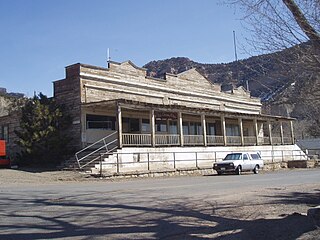
Kenilworth is a census-designated place in northern Carbon County, Utah, United States.

Zahl is an unincorporated community in northwestern Williams County, North Dakota, United States. It lies along North Dakota Highway 50 north of the city of Williston, the county seat of Williams County.
Lefor is an unincorporated community in southern Stark County, North Dakota, United States. It lies southeast of the city of Dickinson, the county seat of Stark County. Its elevation is 2,592 feet (790 m). Lefor's post office closed November 2, 2002, but the town still has its own ZIP code of 58641.

St. Anthony or Saint Anthony is an unincorporated town in southeastern Morton County, North Dakota, United States. It lies a short distance to the west of North Dakota Highway 6, south of the city of Mandan, the county seat of Morton County. It has the ZIP code 58566. In 2018, the population was estimated to be less than 30.

Arvilla is an unincorporated community in central Grand Forks County, North Dakota, United States. It lies along U.S. Route 2, west of the city of Grand Forks, the county seat of Grand Forks County. Its elevation is 1,004 feet (306 m). The community was first named Orange for Orange County, New York; it was renamed Arvilla for Arvilla Estella Hersey, the wife of a local farmer. Although Arvilla is unincorporated, it has a post office, with the ZIP code of 58214.

Menoken is an unincorporated community and a census-designated place (CDP) in southwestern Burleigh County, North Dakota, United States. It was designated as part of the U.S. Census Bureau's Participant Statistical Areas Program on June 10, 2010. It was not counted separately during the 2000 Census, but was included in the 2010 Census, where a population of 70 was reported.

Beeler is an unincorporated community in Ness County, Kansas, United States. It lies along K-96, west of the city of Ness City, the county seat of Ness County. It has a post office with the ZIP code 67518.
Fruitland is an unincorporated community in western Duchesne County, Utah, United States, on the Uintah and Ouray Indian Reservation.
Hanna is an unincorporated community in western Duchesne County, Utah, United States, on the Uintah and Ouray Indian Reservation.

Peoa is an unincorporated census-designated place in southwestern Summit County, Utah, United States, between Jordanelle and Rockport State Parks. It lies along State Route 32, south of the city of Coalville, the county seat of Summit County. Its elevation is 6,191 feet (1,887 m). The population was 253 at the 2010 census. Peoa is unincorporated with the ZIP code of 84061.
Greenwich is an unincorporated community in northeastern Piute County, Utah, United States, just east of the Fishlake National Forest. It lies along State Route 62 northeast of the town of Junction, the county seat of Piute County. Its elevation is 6,854 feet (2,089 m). Although Greenwich is unincorporated, it has a post office, with the ZIP code of 84732. Greenwich is said to be an anglicized form of a Native American name.

Sevier is an unincorporated community in southwestern Sevier County, Utah, United States. It lies in the valley of the Sevier River along Sevier Highway, the former route of U.S. Route 89, southwest of the city of Richfield, the county seat of Sevier County. Its elevation is 5,584 feet (1,702 m).
Creston is an unincorporated community in southeastern Wirt County, West Virginia, United States. It lies at the confluence of the Little Kanawha River and the West Fork Little Kanawha River on West Virginia Route 5, southeast of the town of Elizabeth, the county seat of Wirt County. Its elevation is 653 feet (199 m). Creston had a post office, which closed on June 25, 2011. The community was named for a drainage divide near the town site.
Call is an unincorporated community in central Newton County, Texas, United States. It lies along State Highway 87 south of the city of Newton, the county seat of Newton County. Its elevation is 95 feet (29 m), and it is located at 30°36′45″N93°52′28″W. Although Call is unincorporated, it has a post office, with the ZIP code of 75933.
Corral is an unincorporated community in southwestern Camas County, Idaho, United States. It lies along U.S. Route 20 west of the city of Fairfield, the county seat of Camas County. Its elevation is 5,098 feet (1,554 m). Although Corral is unincorporated, it has a post office, with the ZIP code of 83322.

Leiter is an unincorporated community in eastern Sheridan County, Wyoming, United States, along Clear Creek. It lies along the concurrent U.S. Routes 14 and 16, east of the city of Sheridan, the county seat of Sheridan County. Its elevation is 3,779 feet (1,152 m). Although Leiter is unincorporated, it has a post office, with the ZIP code of 82837. Public education in the community of Clearmont is provided by Sheridan County School District #3.
Vancourt is an unincorporated community in eastern Tom Green County, Texas, United States. It lies along U.S. Route 87 east of the city of San Angelo, the county seat of Tom Green County. Its elevation is 1,867 feet (569 m). Although Vancourt is unincorporated, it has a post office, with the ZIP code of 76955; the ZCTA for ZIP Code 76955 had a population of 108 at the 2000 census.
Dodge is an unincorporated community in eastern Walker County, Texas, United States, on the northern edge of the Sam Houston National Forest. It lies along FM 405 east of the city of Huntsville, the county seat of Walker County. Its elevation is 400 feet (122 m). Although Dodge is unincorporated, it has a post office, with the ZIP code of 77334; the ZCTA for ZIP Code 77334 had a population of 184 at the 2000 census.


