Rockwood Municipal Airport is a public use airport in Morgan County and Cumberland County, Tennessee, United States. It is located three nautical miles (6 km) north of Rockwood, which owns the airport, and about 6 miles (9.7 km) west of the Harriman, both cities in Roane County. Situated on Walden Ridge near the southern end of the Cumberland Plateau, the airport is convenient to Interstate 40. It is included in the National Plan of Integrated Airport Systems for 2011–2015, which categorized it as a general aviation facility.
Springdale Municipal Airport is a public use airport in Washington County, Arkansas, United States. It is owned by the City of Springdale and located one nautical mile (2 km) southeast of its central business district. This airport is included in the National Plan of Integrated Airport Systems for 2011–2015, which categorized it as a general aviation facility.
Tullahoma Regional Airport, also known as William Northern Field and Soesbe-Martin Field, is a public use airport in Coffee County, Tennessee, United States. It is owned by the City of Tullahoma and located two nautical miles (4 km) northwest of its central business district. This airport is included in the National Plan of Integrated Airport Systems for 2011–2015, which categorized it as a general aviation facility.

Grant County Regional Airport - GCRA is in Grant County, Oregon, a mile southwest of John Day, Oregon. The National Plan of Integrated Airport Systems for 2011–2015 categorized it as a general aviation facility.

Prineville Airport is a public use airport located three nautical miles southwest of the central business district of Prineville, in Crook County, Oregon, United States. According to the FAA's National Plan of Integrated Airport Systems for 2009–2013, it is classified as a general aviation airport.
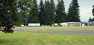
Scappoose Airport is a public use airport located one nautical mile (1.85 km) northeast of the central business district of Scappoose, in Columbia County, Oregon, United States. It is owned and operated by the Port of Columbia County, an Oregon port district and municipal corporation, on behalf of district residents. According to the FAA's National Plan of Integrated Airport Systems for 2009–2013, it is categorized as a general aviation airport.

Tillamook Airport is a public use airport located 3 miles (4.8 km) south of the central business district of Tillamook, a city in Tillamook County, Oregon, United States. It is owned by the Port of Tillamook Bay. According to the FAA's National Plan of Integrated Airport Systems for 2009–2013, it is categorized as a general aviation facility.
Zelienople Municipal Airport is a public airport in Beaver County, Pennsylvania, a mile west of Zelienople, a borough in Butler County, Pennsylvania, in the Pittsburgh metropolitan area. The airport is owned by the Borough of Zelienople and operated by the Zelienople Municipal Authority. The National Plan of Integrated Airport Systems for 2011–2015 categorized it as a general aviation facility.
Richard Arthur Field is a city-owned public-use airport located three nautical miles northeast of the central business district of Fayette, a city in Fayette County, Alabama, United States.

Murfreesboro Municipal Airport is a city-owned, public-use airport located two nautical miles (3.7 km) north of the central business district of Murfreesboro, a city in Rutherford County, Tennessee, United States. This airport is included in the National Plan of Integrated Airport Systems for 2011–2015, which categorized it as a general aviation airport. Although most U.S. airports use the same three-letter location identifier for the FAA and IATA, this airport is assigned MBT by the FAA, but has no designation from the IATA.
Huntington Municipal Airport is a city-owned, public-use airport located three nautical miles southeast of the central business district of Huntington, a city in Huntington County, Indiana, United States. According to the FAA's National Plan of Integrated Airport Systems for 2009–2013, it was classified as a general aviation airport.

Abernathy Field is a public use airport located three nautical miles southwest of the central business district of Pulaski, a city in Giles County, Tennessee, United States. It is owned by the City of Pulaski and Giles County. According to the FAA's National Plan of Integrated Airport Systems for 2009–2013, it is categorized as a general aviation facility.
Campbell County Airport is a county-owned, public-use airport located 1 kilometre (0.62 mi) east of the central business district of Jacksboro, a town in Campbell County, Tennessee, United States. This airport is included in the FAA's National Plan of Integrated Airport Systems for 2011–2015, which categorized it as a general aviation facility.
Beech River Regional Airport is a public-use airport in Henderson County, Tennessee, United States. It is located five nautical miles northwest of the central business district of Parsons, a city in Decatur County.
Carroll County Airport is a county-owned public-use airport in Carroll County, Tennessee, United States. It is located four nautical miles northwest of the central business district of Huntingdon, Tennessee. The airport is included in the FAA's National Plan of Integrated Airport Systems for 2011–2015, which categorized it as a general aviation facility.
Warren County Memorial Airport is a county-owned public-use airport in Warren County, Tennessee, United States. It is located three nautical miles (6 km) west of the central business district of McMinnville, Tennessee. This airport is included in the National Plan of Integrated Airport Systems for 2011–2015, which categorized it as a general aviation facility.
Hawkins County Airport is a county-owned public-use airport in Hawkins County, Tennessee, United States. It is located six nautical miles northeast of the central business district of Rogersville, Tennessee in the city of Surgoinsville, Tennessee. This airport is included in the National Plan of Integrated Airport Systems for 2011–2015, which categorized it as a general aviation facility.
Maury County Airport is a county-owned public-use airport in Maury County, Tennessee, United States. It is located 2 nautical miles northeast of the central business district of Mount Pleasant, Tennessee and 8 nautical miles southwest of Columbia, Tennessee.
Fayetteville Municipal Airport is a public use airport located six nautical miles south of the central business district of Fayetteville, a city in Lincoln County, Tennessee, United States, in the community of Park City. It is owned by the Fayetteville-Lincoln Airport Authority. It is included in the National Plan of Integrated Airport Systems for 2011–2015, which categorized it as a general aviation airport.
Mettel Field is a public airport three miles north of Connersville, in Fayette County, Indiana. It is owned by the Connersville Board of Aviation Commissioners. The National Plan of Integrated Airport Systems for 2011–2015 categorized it as a general aviation facility.

