Flood Control Act of 1928

Last updated

The Flood Control Act of 1928 (FCA 1928) (70th United States Congress, Sess. 1. Ch. 569, enacted May 15, 1928) authorized the United States Army Corps of Engineers to design and construct projects for the control of floods on the Mississippi River and its tributaries as well as the Sacramento River in California. [1] It was sponsored by Senator Wesley L. Jones (R) of Washington and Representative Frank R. Reid (R) of Illinois,[ citation needed ] in response to the Great Mississippi Flood of 1927.

Contents

Significance

FCA 1928 had three important effects. It increased public awareness of advances in flood control theory and practice. It put flood control on par with other major projects of its time with the largest public works appropriation ever authorized. And, FCA 1928 increased debate on local contributions to a new level. [2]

Section 1: Mississippi River Valley project

Authorized the project for the flood control of the Mississippi River in its alluvial valley and for its improvement from Head of Passes to Cape Girardeau, Missouri, in accordance with the engineering plan set forth and recommended in the report submitted by the Chief of Engineers of the U.S. Army Corps of Engineers.

Created a board consisting of the Chief of Engineers, the president of the Mississippi River Commission, and a civil engineer chosen from civil life appointed by the President of the United States. The board was to consider the engineering differences between the project adopted by the Act (the Chief of Engineers' plans) and plans recommended by the Mississippi River Commission. The project and the changes therein are to be executed in accordance with section 8 of the Act.

Directed surveys to be made between Baton Rouge, Louisiana, and Cape Girardeau, Missouri to ascertain and determine the best method of securing flood relief in addition to levees. These surveys were to be made before any flood-control works other than levees and revetments are undertaken on that portion of the river.

Directed the character of diversion works and outlets. They are to be built in a manner and of a character which will fully and amply protect the adjacent lands ensuring the same degree of protection on the east side as is afforded by levees on the west side of the river. Nothing in the Act was meant to prevent, postpone, delay, or in anywise interfere with the execution of that part of the project on the east side of the river.

Consolidated funding. All unexpended balances of previous appropriations for flood control on the Mississippi River under the Flood Control Act of 1917 and the Flood Control Act of 1923, were made available for expenditure except for work under section 13.

Section 2: Local contribution and participation

Reiterated the soundness of the principle of local contribution toward the cost of flood-control work which had been incorporated in all previous national legislation, recognizing the special interest of the local population in its own protection, and as a means of preventing inordinate requests for unjustified items of work having no material national interest.

Recognized the expenditure estimated at approximately $292 million already made by the local interests; in view of the extent of national concern in the control of these floods in the interests of national prosperity, the flow of interstate commerce, and the movement of the United States mails; and, in view of the gigantic scale of the project, involving flood waters of a volume and flowing from a drainage area largely outside the States most affected, and far exceeding those of any other river in the United States, no local contribution to the project was required, and given.

Section 3: Local entities must maintain completed projects

This section prohibited expending funds until the states or levee districts gave assurances that they would maintain all flood-control works after their completion, except controlling and regulating spillway structures, including special relief levees; would agree to accept land turned over to them, and provide without cost to the United States, all rights of way for levee foundations and levees on the main stem of the Mississippi River between Cape Girardeau, Missouri, and the Head of Passes.

Relief from liability

A key provision of FCA 1928 was that no liability of any kind would attach to or rest upon the United States for any damage from or by floods or flood waters at any place. The act also stated that, if on any stretch of the banks of the Mississippi River it was impracticable to construct levees (either because such construction is not economically justified or because such construction would unreasonably restrict the flood channel) and previously unaffected lands are subjected to overflow and damage by reason of the construction of levees on the opposite banks of the river, the government has a duty to acquire either ownership or flowage rights over such lands.

In January 2008, this liability provision played a controversial role concerning the legal cases resulting from the levee failures in New Orleans during the Hurricane Katrina disaster in 2005. Federal Judge Stanwood Duval, of the US District Court for Eastern Louisiana, held the US Army Corps of Engineers responsible for defects in the design of the concrete I-wall floodwall constructed in the earthen levees of the 17th Street Canal in the period following Hurricane Betsy (1965). However, he further stated that the agency could not be held financially liable due to the sovereign immunity provided by this legislation. [3]

In April 2010, scholars with the Louisiana State Office of Historic Preservation approved the text for a Historic Plaque for the 17th Street Canal. [4] After receiving permission from city agencies and the Corps of Engineers, the flood protection group Levees.org installed the Plaque at ground zero, on New Orleans city property, in the Lakeview neighborhood. [5] The text of the plaque read as follows:

On August 29, 2005, a federal floodwall atop a levee on the 17th Street Canal, the largest and most important drainage canal for the city, gave way here causing flooding that killed hundreds. This breach was one of 50 ruptures in the federal Flood Protection System that occurred that day. In 2008, the US District Court placed responsibility for this floodwall's collapse squarely on the US Army Corps of Engineers; however, the agency is protected from financial liability in the Flood Control Act of 1928.

Section 4: Flowage Rights

Provide Federal government flowage rights for additional destructive flood waters that will pass by reason of diversions from the main channel of the Mississippi River. Provided that any benefits to property from execution of the flood-control plan would be taken into consideration in reducing the amount of compensation paid for flowage rights.

Provided a method to obtain lands to execute the plan. The Government can acquire by condemnation, purchase, or donation any lands, easements, or rights of way which are needed in carrying out this project. Provisions of the Rivers and Harbors Act of 1918 were made applicable to the acquisition of lands, easements, or rights of way needed for works of flood control.

Section 5: Surveys

The Secretary of War, on the recommendation of the Chief of Engineers, could engage the services and assistance of the Coast and Geodetic Survey, the United States Geological Survey, or other Government mapping agencies, in preparing maps required for this project.

Section 6: Rights of Way

Authorized expenditure of funds up to $10 million for previously authorized flood control works on the Mississippi River, including levee work on the Mississippi River between Rock Island, Illinois, and Cape Girardeau, Missouri, and outlets and tributaries affected by the backwaters of the Mississippi. Stipulated that, between Rock Island, Illinois, and Cape Girardeau, Missouri, the States or levee districts are to provide rights of way at no cost to the United States, contribute one-third of the costs, and maintain them after completion.

Authorized emergency expenses. In an emergency, funds may be expended for the maintenance of any levee when it is demonstrated that the levee can not be adequately maintained by the State or levee district. Since Section 9 of the United States Constitution prohibits spending of public money except by the express direction of Congress, this authorization allows the Government to step in to assist local and state governments in an emergency. [6]

Section 7: Emergency fund

$5 million was authorized as an emergency fund in rescue work or in the repair or maintenance of any flood-control work on any tributaries of the Mississippi River threatened or destroyed by flood including the flood of 1927.

Section 8: Work of the Mississippi River Commission

The Mississippi River Commission, under direction of the Secretary of War and supervision of the Chief of Engineers was to execute the project. For all other purposes, the existing laws governing the commission remained unchanged. The commission was to inspect frequently enough and hold hearings to enable it to acquire first-hand information as to conditions and problems of flood control within the area of its jurisdiction. It established that the president/executive officer of the commission is to qualifications prescribed by law for the Assistant Chief of Engineers and be given the rank, pay, and allowances of a brigadier general. It established the salaries for officers of the Commission.

Section 10: Proceed speedily and provide reports on various rivers systems

Surveys of the Mississippi River and its tributaries were to be done as speedily as practicable.

Directed the Corps of Engineers to prepare and submit reports on projects for flood control on tributaries of the Mississippi River including

The reports were to include

This direction from Congress had the impact of forcing the balancing of competing interests when considering flood control projects.[ citation needed ]

Authorized $5 million to be used out of the appropriation authorized by the Act, in addition to amounts authorized in the Rivers and Harbors Act of 1927, to be expended for the projects authorized. Directed flood surveys to be made simultaneously with the flood-control work on the Mississippi River.

Directed that the United States Department of Agriculture and such other agencies determine how Mississippi Valley floods may be controlled by proper forestry practice.

Section 11: Previous projects below Cape Girardeau

Directed the Mississippi River Commission to examine the Mississippi River below Cape Girardeau, Missouri, where levees had previously been constructed on one side of the river and adversely affected land on the other side of the river. Directed construction of levees possible to reduce the impact if economically justified.

Concerning a recommendation by the Mississippi River Commission in October 1912 to build a levee from Tiptonville, Tennessee, to the Obion River in Tennessee, the Commission was authorized to resurvey the proposed levee and relocate the same if necessary. If such levee was found feasible and approved by the board, it shall be built out of appropriations hereafter to be made.

Section 12: All other laws inconsistent with this law are repealed

All laws or parts of laws inconsistent with FCA 1928 were repealed.

Section 13: Sacramento River flood control

The project for the control of floods in the Sacramento River, California, adopted by section 2 of the Act approved March 1, 1917, entitled "An Act to provide for the control of the floods of the Mississippi River and of the Sacramento River, California, and for other purposes," is hereby modified in accordance with the report of the California Debris Commission, provided that the total amounts contributed by the Federal Government, including previous amounts contributed, shall not exceed $17.6 million.

Section 14: Title 41 USC is applicable

In every contract or agreement to be made or entered into for the acquisition of land either by private sale or condemnation as in this Act provided the provisions contained in section 3741 of the Revised Statutes being section 22 of title 41 of the United States Code shall be applicable.

See also

For related legislation which sometime also implement flood control provisions, see the following:

Related Research Articles

<span class="mw-page-title-main">Levee</span> Ridge or wall to hold back water

A levee, dike, dyke, embankment, floodbank, or stop bank is a structure used to keep the course of rivers from changing and to protect against flooding of the area adjoining the river or coast. It is usually earthen and often runs parallel to the course of a river in its floodplain or along low-lying coastlines.

<span class="mw-page-title-main">Meramec River</span> River in the American state of Missouri

The Meramec River, sometimes spelled Maramec River, is one of the longest free-flowing waterways in the U.S. state of Missouri, draining 3,980 square miles (10,300 km2) while wandering 218 miles (351 km) from headwaters southeast of Salem to where it empties into the Mississippi River near St. Louis at Arnold and Oakville. The Meramec watershed covers six Missouri Ozark Highland counties—Dent, Phelps, Crawford, Franklin, Jefferson, and St. Louis—and portions of eight others—Maries, Gasconade, Iron, Washington, Reynolds, St. Francois, Ste. Genevieve, and Texas. Between its source and its mouth, it falls 1,025 feet (312 m). Year-round navigability begins above Maramec Spring, just south of St. James. The Meramec's size increases at the confluence of the Dry Fork, and its navigability continues until the river enters the Mississippi at Arnold, Missouri.

<span class="mw-page-title-main">Pick–Sloan Missouri Basin Program</span> Flood control

The Pick–Sloan Missouri Basin Program, formerly called the Missouri River Basin Project, was initially authorized by the Flood Control Act of 1944, which approved the plan for the conservation, control, and use of water resources in the Missouri River Basin.

<span class="mw-page-title-main">Mississippi Valley Division</span> One of the eight permanent divisions of the U.S. Army Corps of Engineers

The United States Army Corps of Engineers Mississippi Valley Division (MVD) is responsible for the Corps water resources programs within 370,000-square-miles of the Mississippi River Valley, as well as the watershed portions of the Red River of the North that are within the United States. It encompasses the entire Mississippi River from Lake Itasca, Minnesota, to the Gulf of Mexico. It excludes the watersheds of the Missouri River and Ohio River, and portions of the Arkansas River and the Red River of the South. The division includes all or parts of 13 states: Arkansas, Illinois, Iowa, Kentucky, Louisiana, Michigan, Minnesota, Mississippi, Missouri, North Dakota, Tennessee, Wisconsin, and South Dakota.

In the United States, there are multiple laws known as the Flood Control Act (FCA). Typically, they are enacted to control irrigation because of floods or other natural disasters and are administered by the United States Army Corps of Engineers. These laws were enacted beginning in 1917, with the most recent one being passed in 1965.

From 1890 through 2006, the Orleans Levee Board (OLB) was the body of commissioners that oversaw the Orleans Levee District (OLD) which supervised the levee and floodwall system in Orleans Parish, Louisiana The role of the OLB has changed over time. Prior to Hurricane Betsy in 1965, the OLB developed land and sold it to raise money to build and improve flood protection levees. After Betsy, Congress passed the Flood Control Act of 1965 which directed the Army Corps of Engineers to design and build the hurricane flood protection system enveloping New Orleans. Owing to the 1965 legislation, the OLB's duties were now limited to collecting the 30% cost share for project design and construction, and to maintaining and operating completed flood protection structures.

On Monday, August 29, 2005, there were over 50 failures of the levees and flood walls protecting New Orleans, Louisiana, and its suburbs following passage of Hurricane Katrina. The failures caused flooding in 80% of New Orleans and all of St. Bernard Parish. In New Orleans alone, 134,000 housing units — 70% of all occupied units — suffered damage from Hurricane Katrina and the subsequent flooding.

<span class="mw-page-title-main">Bonnet Carré Spillway</span> Flood control operation in the Lower Mississippi Valley, US

The Bonnet Carré Spillway is a flood control operation in the Lower Mississippi Valley. Located in St. Charles Parish, Louisiana, about 12 miles (19 km) west of New Orleans, it allows floodwaters from the Mississippi River to flow into Lake Pontchartrain and thence into the Gulf of Mexico. The spillway was constructed between 1929 and 1931, following the Great Mississippi Flood of 1927, and has been designated as a National Historic Civil Engineering Landmark by the American Society of Civil Engineers.

The Flood Control Act of 1965, Title II of Pub. L.Tooltip Public Law  89–298, was enacted on October 27, 1965, by the 89th Congress and authorized the United States Army Corps of Engineers to design and construct numerous flood control projects including the Lake Pontchartrain and Vicinity, Louisiana Hurricane Protection Project in the New Orleans region of south Louisiana.

The United States Army Corps of Engineers is involved with a wide spectrum of public works projects: environmental protection, water supply, recreation, flood damage and reduction, beach nourishment, homeland security, military construction, and support to other Governmental agencies. Through 19 Flood Control Acts since 1917, Congress has authorized the Corps of Engineers to be involved with flood protection and damage reduction in almost every state of the union.

The Flood Control Act of 1936, Pub. L.Tooltip Public Law  74–738, was an Act of the United States Congress signed into law by President Franklin Delano Roosevelt on 22 June 1936. It authorized civil engineering projects such as dams, levees, dikes, and other flood control measures through the United States Army Corps of Engineers and other Federal agencies. It is one of a number of Flood Control Acts passed on a regular basis by the United States Congress. FCA 1936 was introduced in Congress by Riley J. Wilson.

Water Resources Development Act of 1988, Pub. L.Tooltip Public Law  100–676, is a public law passed by Congress on November 17, 1988 concerning water resources in the United States in the areas of flood control, navigation, dredging, environment, recreation, water supply, beach nourishment and erosion.

The Water Resources Development Act of 1999, Pub. L.Tooltip Public Law  106–53 (text)(PDF), was enacted by Congress of the United States on August 17, 1999. Most of the provisions of WRDA 1999 are administered by the United States Army Corps of Engineers.

The Water Resources Development Act of 2000, Pub. L.Tooltip Public Law  106–541 (text)(PDF), was enacted by Congress of the United States on December 11, 2000. Most of the provisions of WRDA 2000 are administered by the United States Army Corps of Engineers.

The Flood Control Act of 1917 is an Act of Congress enacted in response to costly floods in the lower Mississippi Valley, the Northeast, and the Ohio Valley between 1907 and 1913.

The Flood Control Act of 1937 was an Act of the United States Congress signed into law by President Franklin D. Roosevelt on August 28, 1937, as Public Law 406. The act was a response to major flooding throughout the United States in the 1930s, culminating with the "Super Flood" of January 1937, the greatest flood recorded on the lower Ohio River. FCA 1937 provided nearly $25 million for initial construction of projects selected by the Chief of Engineers from those listed in the Ohio Valley Flood Control Program. Among the numerous projects authorized, the act provided for construction of floodwalls, levees, and revetments along Wolf River and Nonconnah Creek for protection of Memphis, TN and modified the Yazoo River project to substitute a combined reservoir floodway and levee plan.

<span class="mw-page-title-main">New Orleans Outfall Canals</span> New Orleans drainage canals

There are three outfall canals in New Orleans, Louisiana – the 17th Street, Orleans Avenue and London Avenue canals. These canals are a critical element of New Orleans’ flood control system, serving as drainage conduits for much of the city. There are 13 miles (21 km) of levees and floodwalls that line the sides of the canals. The 17th Street Canal is the largest and most important drainage canal and is capable of conveying more water than the Orleans Avenue and London Avenue Canals combined.

<span class="mw-page-title-main">2011 Mississippi River floods</span> 2011 major floods in the United States

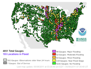
Major floods along the Mississippi River in April and May 2011 were among the largest and most damaging recorded along the U.S. waterway in the past century, comparable in extent to the Great Mississippi Flood of 1927 and Great Flood of 1993. In April 2011, two large storm systems deposited record levels of rainfall on the Mississippi River drainage basin. When that additional water combined with the springtime snowmelt, the river and many of its tributaries began to swell to record levels by the beginning of May. Flooding occurred in Illinois, Missouri, Kentucky, Tennessee, Arkansas, Mississippi, and Louisiana.

<span class="mw-page-title-main">Birds Point-New Madrid Floodway</span>

The Birds Point-New Madrid Floodway is a flood control component of the Mississippi River and Tributaries Project located on the west bank of the Mississippi River in southeast Missouri just below the confluence of the Ohio and Mississippi Rivers. The construction of the floodway was authorized by the Flood Control Act of 1928 and later modified by the Flood Control Act of 1965. Its purpose is to divert water from the Mississippi River during major flood events and lower the flood stages upstream, notably at Cairo, Illinois.

<span class="mw-page-title-main">Project design flood</span>

The project design flood is a hypothetical "maximum probable" flood of the Mississippi River used by the United States Army Corps of Engineers to aid in the design and execution of flood protection in the Mississippi Valley.

References

  1. "Mississippi Valley Division > About > Mississippi River Commission (MRC) > History". www.mvd.usace.army.mil. Archived from the original on January 9, 2009.
  2. The Evolution of the Flood Control Act of 1936 Archived 2011-05-29 at the Wayback Machine
  3. Nossiter, Adam (February 2008). "In Court Ruling on Floods, More Pain for New Orleans". The New York Times.
  4. "Approval Letter for 17th Street Plaque Dated April 30, 2010 | PDF".
  5. "State Historic Plaque Placed At 17th Street Canal - New Orleans News Story - WDSU New Orleans". Archived from the original on 2012-04-05.
  6. "The United States Constitution - The U.S. Constitution Online - USConstitution.net". www.usconstitution.net.