Chania, also sometimes romanized as Hania, is a city in Greece and the capital of the Chania regional unit. It lies along the north west coast of the island Crete, about 70 km (43 mi) west of Rethymno and 145 km (90 mi) west of Heraklion.

Heraklion or Herakleion, sometimes Iraklion, is the largest city and the administrative capital of the island of Crete and capital of Heraklion regional unit. It is the fourth largest city in Greece with a municipal population of 179,302 (2021) and 211,370 in its wider metropolitan area, according to the 2011 census.

The history of Crete goes back to the 7th millennium BC, preceding the ancient Minoan civilization by more than four millennia. The Minoan civilization was the first civilization in Europe.

Monemvasia is a town and municipality in Laconia, Greece. The town is located in mainland Greece on a tied island off the east coast of the Peloponnese, surrounded by the Myrtoan Sea. Monemvasia is connected to the rest of the mainland by a tombolo 400 metres (1,300 ft) in length.
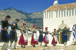
The Sfakians are the inhabitants of the region of Sfakia located in western Crete. The Sfakians hold themselves to be the direct descendants of the Dorians who came down to Crete around 1100 BC.

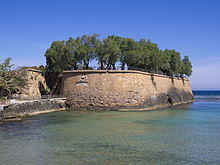
Kydonia, also known as Cydonia was an ancient city located at the site of present-day Chania on the island of Crete in Greece. The city is known from archaeological remains dating back to the Minoan era as well as literary and historical sources.

Souda Bay is a bay and natural harbour near the town of Souda on the northwest coast of the Greek island of Crete. The bay is about 15 km long and only two to four km wide, and a deep natural harbour. It is formed between the Akrotiri peninsula and Cape Drapano, and runs west to east. The bay is overlooked on both sides by hills, with a relatively low and narrow isthmus in the west near Chania.

The Koules or Castello a Mare is a fortress located at the entrance of the old port of Heraklion, Crete, Greece. It was built by the Republic of Venice in the early 16th century, and is still in good condition today.

The Fortezza is the citadel of the city of Rethymno in Crete, Greece. It was built by the Venetians in the 16th century, and was captured by the Ottomans in 1646. By the early 20th century, many houses were built within the citadel. These were demolished after World War II, leaving only a few historic buildings within the Fortezza. Today, the citadel is in good condition and is open to the public.

Gonia Monastery, Monastery of Our Lady of Gonia or Monastery of Panagia Hodegetria is an Orthodox monastery located 1 km north of Kolymvari and some 26 km from Chania, on the southeast coast of the Rodopos peninsula in Crete, Greece, overlooking the Gulf of Chania. The monastery was given the same name as Hodegon Monastery in Constantinople. Both were named in honor of the sacred icon painted by Luke the Evanglist. The icon featured the Virgin and Child. It is traditionally called Hodegetria. Some churches adopted the name Madonna of Constantinopli in honor of the Hodegetria icon.
Palaiokastro is a coastal village and a community in the municipality of Malevizi. 9 km west of Heraklion on the island of Crete. In 2011 Palaiokastro had a population of 255. It is situated in front of a 70 meter long pebbled beach leading to a cove with rapidly deepening waters that are protected from the prevailing northerly winds. On the southern end of the beach rises a steep calcareous rock. During the Venetian occupation of Crete extensive fortifications were built on this rock, housing cannons that secured the bay of Heraklion. Ruins of the fortress walls survive until today.
The Realm or Kingdom of Candia or Duchy of Candia was the official name of Crete during the island's period as an overseas colony of the Republic of Venice, from the initial Venetian conquest in 1205–1212 to its fall to the Ottoman Empire during the Cretan War (1645–1669). The island was at the time and up to the early modern era commonly known as Candia after its capital, Candia or Chandax. In modern Greek historiography, the period is known as the Venetocracy.

The Walls of Nicosia, also known as the Venetian Walls, are a series of defensive walls which surround Nicosia, the capital city of Cyprus. The first city walls were built in the Middle Ages, but they were completely rebuilt in the mid-16th century by the Republic of Venice. The walls are still largely intact, and are among the best preserved Renaissance fortifications in the Eastern Mediterranean. They are a major tourist attraction.

Rethymno is a city in Greece on the island of Crete. It is the capital of Rethymno regional unit, and has a population of more than 34,000 inhabitants.

The New Fortress of Corfu is a Venetian fortress built on the hill of St. Mark in Corfu in stages. The original architect of the fort was the military engineer Ferrante Vitelli. The current buildings which exist within the fortress were built by the British during their rule of the island (1815–63).

The fortifications of Mdina are a series of defensive walls which surround the former capital city of Mdina, Malta. The city was founded as Maleth by the Phoenicians in around the 8th century BC, and it later became part of the Roman Empire under the name Melite. The ancient city was surrounded by walls, but very few remains of these have survived.
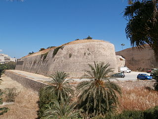
The fortifications of Heraklion are a series of defensive walls and other fortifications which surround the city of Heraklion in Crete, Greece. The first city walls were built in the Middle Ages, but they were completely rebuilt by the Republic of Venice. The fortifications managed to withstand the second longest siege in history for 21 years, before the city fell to the Ottomans in 1669.

The Parga Castle is a medieval hilltop citadel complex in the town of Parga, Epirus, Greece. Located on the top of a hill overlooking the town, it has been an important landmark since the 15th century due in part to the strong fortifications used to protect the town from invasions from land and sea.

The Castle of Santa Maura is a fortress on the northeastern tip of the Greek island of Lefkada. The castle began as a small fortification in c. 1300 to control access to the island, before it was expanded to become a walled town and the island's capital by the early 15th century. The Ottoman Empire took possession in 1479, and a century later rebuilt and enlarged it, giving it largely its present shape. A sizeable town grew outside the castle walls by the 1670s.