Fringing reef

Last updated
A fringing reef off the coast of Eilat, Israel EilatFringingReef.jpg
A fringing reef off the coast of Eilat, Israel
Exposed reef flats during low tide at the Magpupungko Rock Pools in Siargao Island, Philippines Special Awards Magpupungko Category.jpg
Exposed reef flats during low tide at the Magpupungko Rock Pools in Siargao Island, Philippines

A fringing reef is one of the three main types of coral reef. It is distinguished from the other main types, barrier reefs and atolls, in that it has either an entirely shallow backreef zone (lagoon) or none at all. If a fringing reef grows directly from the shoreline, then the reef flat extends to the beach and there is no backreef. In other cases (e.g., most of the Bahamas), fringing reefs may grow hundreds of yards from shore and contain extensive backreef areas within which it contains food and water. Some examples of this are Philippines, Indonesia, Timor-Leste, the western coast of Australia, the Caribbean, East Africa, and Red Sea. [1] [2] [3] Charles Darwin believed that fringing reefs are the first kind of reefs to form around a landmass in a long-term reef growth process. [4] The largest fringing coral reef in the world is the Ningaloo Reef, stretching to around 260 km (160 mi) along the coastline of Western Australia. [1]

Contents

Barrier reef

There are few differences between fringing reefs and barrier reefs. Distinguishing between these two reef types involves assessing the depth of the lagoon behind the back reef. Barrier reefs feature deeper sections within the lagoon, while fringing reefs lack such depths. Additionally, a notable contrast lies in their proximity to the shore: barrier reefs are typically located much farther away from the coastline compared to fringing reefs. [4]

Structure

Diagram of a fringing coral reef Coral reef diagram.jpg
Diagram of a fringing coral reef

There are two main components that make up a fringing reef: the reef flat and the reef slope.

Reef flat (back reef)

The reef flat is the shoreward, flat, broadest area of the reef. The reef flat is found in fairly shallow water and can be uncovered during low tide. This area of the reef is only slightly sloped towards the open ocean. [5] Since the reef flat is adjacent or nearly adjacent to land, it sustains the most damage from runoff and sediments. Typically, few of the flat's corals are alive. Seagrasses, seaweeds, and soft corals are often found there. [5]

Reef slope (fore reef)

The reef slope is positioned at the outer edge of the fringing reef, bordering the open ocean. Usually characterized by a steep inclination, this part of the reef either descends to a relatively shallow sandy base or extends to depths too significant to facilitate the growth of coral. [5] The diminished presence of runoff and sediments on this slope contributes to a higher abundance of coral and a broader variety of coral species. Greater wave action disperses pollutants while transporting nutrients to this specific area. [5] A prevalent characteristic found on the fore reef involves the creation of spur-and-groove formations, facilitating the downslope transportation of sediment within the groove.

The upper segment of this slope is known as the reef crest. This crest enjoys an optimal balance of sunlight exposure and wave action, fostering the fastest coral growth in this area. Conversely, the base of the slope receives the least amount of sunlight and consequently exhibits the slowest growth among all sections of the slope. [5]

Distribution of Fringing reefs

Aerial view of Ningaloo Reef in Western Australia, the largest fringing coral reef in the world and a UNESCO World Heritage Site Cape Range National Park and Ningaloo Reef from the air.jpg
Aerial view of Ningaloo Reef in Western Australia, the largest fringing coral reef in the world and a UNESCO World Heritage Site

Fringing reefs are located near shore in the tropics in many areas and are the most common reef type. Coral reefs are found in the tropics in which the water is between 18 and 30 °C (64 and 86 °F). [6] Many of the Great Barrier Reef's components are actually fringing reefs. Of the close to 3,400 individual reefs, 760 are fringing reefs. [7] Fringing reefs are the most common type of reef found in the Philippines, Indonesia, Timor-Leste, the western coast of Australia, the Caribbean, East Africa, and Red Sea. [1] [2] [8] [3]

The largest fringing coral reef in the world is the Ningaloo Reef, stretching to around 260 km (160 mi) along the coastline of Western Australia. [1]

Island with fringing reef in the Maldives Maldives - Kurumba Island.jpg
Island with fringing reef in the Maldives

Development of Fringing Reefs

The most important determinant of reef growth is available space as determined by sea level changes. [9] Sea level changes are mostly a result of glaciation or plate tectonics. Tectonic activity can have detrimental effects. An earthquake on Ranongga in the Solomon Islands moved 80% of its fringing reef permanently above sea level. Northern reefs became elevated 1m above the high tide water height, whereas on the south side reefs moved 2 to 3m above the water height. [10]

Keep-up reefs grow at the same rate that sea level rises. Catch-up reefs initially grow more slowly than sea level rises but eventually catch up when the rise in sea level slows or stops. Give-up reefs are not able to grow fast enough and are "drowned out". There are six different major ways in which fringing reefs grow and develop. [4]

Ecology

Uncovered reef flat during low tide on Guam Uncovered reef flat with intervening channels at low tide on the Guam coastline (line382192927).jpg
Uncovered reef flat during low tide on Guam

As with other types of reefs, there are many reasons of fringing reef destruction. Destructive fishing practices, such as cyanide fishing, blast fishing, bottom trawling, and muro-ami (banging on the reef with sticks), may have detrimental effects. Bottom-trawling is one of the greatest threats to cold-water coral reefs. Overfishing affects the ecological balance of coral reef communities, disrupting the food chain and causing effects far beyond the directly overfished population. Tourism such as careless boating, diving, snorkeling, and fishing, with people touching reefs, stirring up sediment, collecting coral, and dropping anchors on reefs, can destroy the reefs. Some tourist resorts and infrastructure have been built directly on top of reefs, and some resorts empty their sewage or other wastes directly into water surrounding coral reefs.

Toxins from marine pollution are dumped directly into the ocean or carried by river systems from sources upstream. Some pollutants, such as sewage and runoff from farming, increase the level of nitrogen in seawater, causing an overgrowth of algae, which cuts off sunlight from the reefs. Erosion caused by construction (both along coasts and inland), mining, logging, and farming is leading to increased sediment in rivers. This ends up in the ocean, where it can smother corals by depriving them of the light needed to survive. The destruction of mangrove forests, which normally trap large amounts of sediment, is exacerbating the problem. Mining of live coral is used as bricks, road fill, or cement for new buildings. Corals are also sold as souvenirs to tourists and to exporters and harvested for the live rock trade.

Corals cannot survive if the water temperature is too high. Climate change has already led to increased levels of coral bleaching, and this is predicted to increase in frequency and severity in the coming decades. Such bleaching events may cause already stressed coral reefs and reef ecosystems to completely die.

Species diversity

Reef edge and flat at Tumon Bay, Guam Reef edge and reef flat in Tumon Bay, Guam (line381088891).jpg
Reef edge and flat at Tumon Bay, Guam

The backreef area has the least species diversity, which increases seaward towards the reef crest. Some of this difference is the result of eutrophication from increased nutrients, sediments and toxicity from domestic and industrial wastes. [11] More macrophytes live on the bottom because of the increase in nutrients. This increase in nutrients has caused an increase in the number of phytoplankton that are present above the coral reef. The increase in phytoplankton has led to reduced light reaching the coral species and has also led to a greater number of larger invertebrates. [11] The sediments that are present within the environment cause increased turbidity and may smother some organisms. The corals present on the fringing reefs use four processes to get rid of sediments which include polyp distension, tentacular movement, ciliary action and mucus production. [11]

In the area of the reef closest to the shore there is generally a lot of fleshy algae which forms on sand and coral rubble. These types of algae include Lyngbia sp. and Oscilatoria sp. [11] Over recent years the dominant species in the reef flat have been affected by environmental changes. On fringing reefs in Barbados, species such as Diploria strigosa , Palythoa mamillosa, and Diadema antillarum are found. [11]

The reef crest's most common species is Porites porites , a type of stony coral, although there are also significant areas covered in flesh-like algae. [11]

See also

Related Research Articles

<span class="mw-page-title-main">Atoll</span> Ring-shaped coral reef

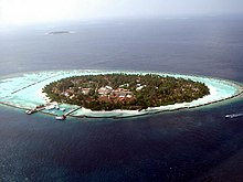
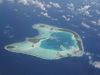
An atoll is a ring-shaped island, including a coral rim that encircles a lagoon. There may be coral islands or cays on the rim. Atolls are located in warm tropical or subtropical parts of the oceans and seas where corals can develop. Most of the approximately 440 atolls in the world are in the Pacific Ocean.

<span class="mw-page-title-main">Estuary</span> Partially enclosed coastal body of brackish water

An estuary is a partially enclosed coastal body of brackish water with one or more rivers or streams flowing into it, and with a free connection to the open sea. Estuaries form a transition zone between river environments and maritime environments and are an example of an ecotone. Estuaries are subject both to marine influences such as tides, waves, and the influx of saline water, and to fluvial influences such as flows of freshwater and sediment. The mixing of seawater and freshwater provides high levels of nutrients both in the water column and in sediment, making estuaries among the most productive natural habitats in the world.

<span class="mw-page-title-main">Lagoon</span> Shallow body of water separated from a larger one by a narrow landform

A lagoon is a shallow body of water separated from a larger body of water by a narrow landform, such as reefs, barrier islands, barrier peninsulas, or isthmuses. Lagoons are commonly divided into coastal lagoons and atoll lagoons. They have also been identified as occurring on mixed-sand and gravel coastlines. There is an overlap between bodies of water classified as coastal lagoons and bodies of water classified as estuaries. Lagoons are common coastal features around many parts of the world.

<span class="mw-page-title-main">Coral reef</span> Outcrop of rock in the sea formed by the growth and deposit of stony coral skeletons

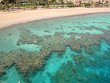
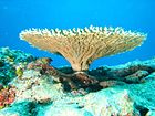
A coral reef is an underwater ecosystem characterized by reef-building corals. Reefs are formed of colonies of coral polyps held together by calcium carbonate. Most coral reefs are built from stony corals, whose polyps cluster in groups.

<span class="mw-page-title-main">Reef</span> A shoal of rock, coral or other sufficiently coherent material, lying beneath the surface of water

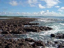
A reef is a ridge or shoal of rock, coral, or similar relatively stable material lying beneath the surface of a natural body of water. Many reefs result from natural, abiotic (non-living) processes such as deposition of sand or wave erosion planing down rock outcrops. However, reefs such as the coral reefs of tropical waters are formed by biotic (living) processes, dominated by corals and coralline algae. Artificial reefs, such as shipwrecks and other man-made underwater structures, may occur intentionally or as the result of an accident. These are sometimes designed to increase the physical complexity of featureless sand bottoms to attract a more diverse range of organisms. Reefs are often quite near to the surface, but not all definitions require this.

<span class="mw-page-title-main">Florida Keys National Marine Sanctuary</span> Marine protected area in Florida, US

The Florida Keys National Marine Sanctuary is a U.S. National Marine Sanctuary in the Florida Keys. It includes the Florida Reef, the only barrier coral reef in North America and the third-largest coral barrier reef in the world. It also has extensive mangrove forest and seagrass fields. The Florida Keys National Marine Sanctuary, designated in 1990, is the ninth national marine sanctuary to be established in a system that comprises 13 sanctuaries and two marine national monuments. The Florida Keys National Marine Sanctuary protects approximately 2,900 square nautical miles of coastal and ocean waters from the estuarine waters of south Florida along the Florida Keys archipelago, encompassing more than 1,700 islands, out to the Dry Tortugas National Park, reaching into the Atlantic Ocean, Florida Bay and the Gulf of Mexico.

<span class="mw-page-title-main">Volcanic island</span> Island of volcanic origin

Geologically, a volcanic island is an island of volcanic origin. The term high island can be used to distinguish such islands from low islands, which are formed from sedimentation or the uplifting of coral reefs.

<span class="mw-page-title-main">Carbonate platform</span> Sedimentary body with topographic relief composed of autochthonous calcareous deposits

A carbonate platform is a sedimentary body which possesses topographic relief, and is composed of autochthonic calcareous deposits. Platform growth is mediated by sessile organisms whose skeletons build up the reef or by organisms which induce carbonate precipitation through their metabolism. Therefore, carbonate platforms can not grow up everywhere: they are not present in places where limiting factors to the life of reef-building organisms exist. Such limiting factors are, among others: light, water temperature, transparency and pH-Value. For example, carbonate sedimentation along the Atlantic South American coasts takes place everywhere but at the mouth of the Amazon River, because of the intense turbidity of the water there. Spectacular examples of present-day carbonate platforms are the Bahama Banks under which the platform is roughly 8 km thick, the Yucatan Peninsula which is up to 2 km thick, the Florida platform, the platform on which the Great Barrier Reef is growing, and the Maldive atolls. All these carbonate platforms and their associated reefs are confined to tropical latitudes. Today's reefs are built mainly by scleractinian corals, but in the distant past other organisms, like archaeocyatha or extinct cnidaria were important reef builders.

<span class="mw-page-title-main">Coral island</span> Island formed from coral and associated material

A coral island is a type of island formed from coral detritus and associated organic material. It occurs in tropical and sub-tropical areas, typically as part of a coral reef which has grown to cover a far larger area under the sea. The term low island can be used to distinguish such islands from high islands, which are formed through volcanic action. Low islands are formed as a result of sedimentation upon a coral reef or of the uplifting of such islands.

<span class="mw-page-title-main">Kadmat Island</span> Coral island of the Lakshadweep archipelago in India

Kadmat Island, also known as Cardamom Island, is a coral island belonging to the Amindivi subgroup of islands of the Lakshadweep archipelago in India. Measuring 9.3 kilometres (5.8 mi) in length, the island has a lagoon with a width of 1.5 kilometres (0.93 mi) covering an area of 25 square kilometres (9.7 sq mi). The ecological feature of the island is of coral reef with seagrass, and marine turtles which nestle here. The Ministry of Environment and Forests (India) has notified the island as a marine protected area for ensuring conservation of the island's animal, plant, or other type of organism, and other resources.

<i>The Structure and Distribution of Coral Reefs</i> Book published in 1842 by Charles Darwin

The Structure and Distribution of Coral Reefs, Being the first part of the geology of the voyage of the Beagle, under the command of Capt. Fitzroy, R.N. during the years 1832 to 1836, was published in 1842 as Charles Darwin's first monograph, and set out his theory of the formation of coral reefs and atolls. He conceived of the idea during the voyage of the Beagle while still in South America, before he had seen a coral island, and wrote it out as HMS Beagle crossed the Pacific Ocean, completing his draft by November 1835. At the time there was great scientific interest in the way that coral reefs formed, and Captain Robert FitzRoy's orders from the Admiralty included the investigation of an atoll as an important scientific aim of the voyage. FitzRoy chose to survey the Keeling Islands in the Indian Ocean. The results supported Darwin's theory that the various types of coral reefs and atolls could be explained by uplift and subsidence of vast areas of the Earth's crust under the oceans.

<span class="mw-page-title-main">Coastal fish</span> Fish that inhabit the sea between the shoreline and the edge of the continental shelf

Coastal fish, also called inshore fish or neritic fish, inhabit the sea between the shoreline and the edge of the continental shelf. Since the continental shelf is usually less than 200 metres (660 ft) deep, it follows that pelagic coastal fish are generally epipelagic fish, inhabiting the sunlit epipelagic zone. Coastal fish can be contrasted with oceanic fish or offshore fish, which inhabit the deep seas beyond the continental shelves.

<span class="mw-page-title-main">Marine habitat</span> Habitat that supports marine life

A marine habitat is a habitat that supports marine life. Marine life depends in some way on the saltwater that is in the sea. A habitat is an ecological or environmental area inhabited by one or more living species. The marine environment supports many kinds of these habitats.

<span class="mw-page-title-main">Algae scrubber</span> Biological water filter

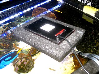
An algae scrubber is a water filtering device which uses light to grow algae; in this process, undesirable chemicals are removed from the water. Algae scrubbers allow saltwater, freshwater and pond hobbyists to operate their tanks using natural filtration in the form of primary production, much like oceans and lakes.

<span class="mw-page-title-main">Mesophotic coral reef</span>

A mesophotic coral reef or mesophotic coral ecosystem (MCE), originally from the Latin word meso (meaning middle) and photic (meaning light), is characterized by the presence of both light-dependent coral and algae, and organisms that can be found in water with low light penetration. Mesophotic coral ecosystems occur at depths beyond those typically associated with coral reefs as the mesophotic ranges from brightly lit to some areas where light does not reach. Mesophotic coral ecosystem (MCEs) is a new, widely-adopted term used to refer to mesophotic coral reefs, as opposed to other similar terms like "deep coral reef communities" and "twilight zone", since those terms sometimes are confused due to their unclear, interchangeable nature. Many species of fish and corals are endemic to the MCEs making these ecosystems a crucial component in maintaining global diversity. Recently, there has been increased focus on the MCEs as these reefs are a crucial part of the coral reef systems serving as a potential refuge area for shallow coral reef taxa such as coral and sponges. Advances in recent technologies such as remotely operated underwater vehicles (ROVs) and autonomous underwater vehicles (AUVs) have enabled humans to conduct further research on these ecosystems and monitor these marine environments.

The Virgin Islands Patch Reefs are numerous, small subtropical coral reef ecoregions. These reefs are located on all three islands: St. John, St. Thomas, and St. Croix. Of the three islands, St. Croix has an established barrier reef. It is approximately 20 meters deep and covers 485 sq km.

<span class="mw-page-title-main">Coral reefs of the Virgin Islands</span> Marine ecosystems found in the Virgin Islands

One of the marine ecosystems found in the Virgin Islands are the coral reefs. These coral reefs can be located between the islands of St. Croix, St. Thomas, and St. John. These coral reefs have an area of 297.9 km2, along with other marine habitats that are in between. The way these coral reefs grow are by coral larvae swimming freely and attaching themselves to hard surfaces around the islands and start to develop a skeleton on the outside of their skin to protect themselves from predators but also allow a new place for other coral larvae to attach to and grow on. These corals can form into three different structures; fringing reefs, which are reefs that are close to the shore, barrier reefs, which are reefs that are alongside the shore and is separated by deep water, and an atoll reef which is a coral reef that circles a lagoon or body of water.

<span class="mw-page-title-main">Coral reefs of Tuvalu</span> List of coral reefs in Tuvalu

The coral reefs of Tuvalu consist of three reef islands and six atolls, containing approximately 710 km2 (270 sq mi) of reef platforms. The islands of the Tuvalu archipelago are spread out between the latitude of 5° to 10° south and longitude of 176° to 180°, west of the International Date Line. The islands of Tuvalu are volcanic in origin. On the atolls, an annular reef rim surrounds the lagoon, and may include natural reef channels. The reef islands have a different structure to the atolls, and are described as reef platforms as they are smaller tabular reef platforms that do not have a salt-water lagoon, although they may have a completely closed rim of dry land, with the remnants of a lagoon that has no direct connection to the open sea or that may be drying up.

<span class="mw-page-title-main">Coral reefs of Kiribati</span> Pacific Ocean Island chain

The Coral reefs of Kiribati consists of 32 atolls and one raised coral island, Banaba, which is an isolated island between Nauru and the Gilbert Islands. The islands of Kiribati are dispersed over 3.5 million km2 (1.4 million sq mi) of the Pacific Ocean and straddle the equator and the 180th meridian, extending into the eastern and western hemispheres, as well as the northern and southern hemispheres. 21 of the 33 islands are inhabited. The groups of islands of Kiribati are:

<span class="mw-page-title-main">Coral reefs of the Solomon Islands</span>

The Coral reefs of the Solomon Islands consists of six major islands and over 986 smaller islands, in Oceania, to the east of Papua New Guinea and northwest of Vanuatu. The Solomon Islands lie between latitudes 5° and 13°S, and longitudes 155° and 169°E. The distance between the westernmost and easternmost islands is about 1,500 km (930 mi). The Santa Cruz Islands are situated north of Vanuatu and are especially isolated at more than 200 km (120 mi) from the other islands. The Solomon Islands has the 22nd largest Exclusive Economic Zone of 1,589,477 km2 (613,701 sq mi) of the Pacific Ocean.

References

  1. 1 2 3 4 "Fringing Reefs". Coral Digest. Retrieved 17 April 2021.
  2. 1 2 Burke, Lauretta; Reytar, Kathleen; Spalding, Mark; Perry, Allison (2012). Reefs at Risk Revisted in the Coral Triangle (PDF). World Resources Institute. ISBN   978-1-56973-791-0.
  3. 1 2 Strykowski, Joe; Bonem, Rena M. (1993). Palaces Under the Sea: A Guide to Understanding the Coral Reef Environment. Star Thrower Foundation. p. 26. ISBN   978-1882533008.
  4. 1 2 3 Kennedy, D.M. and Woodroffe, C.D. 2002.Fringing reef growth and morphology: a review. Earth-Science Reviews. 57:255-277.
  5. 1 2 3 4 5 Castro, Peter and Huber, Michael E. 2008. Marine Biology. 7ed. McGraw-Hill, New York
  6. Zubi, Teresa. 2007. Ecology, Coral Reefs. http://www.starfish.ch/reef/reef.html Accessed on March 30, 2008
  7. Australian Museum. 2004. geoscience: the Earth, Great Barrier Reef. http://www.amonline.net.au/geoscience/earth/barrier_reef.htm Accessed on March 30, 2008.
  8. Arthurton, Russell (2003). "The Fringing Reef Coasts of Eastern Africa—PresentProcesses in Their Long-term Context" (PDF). Western Indian Ocean Journal of Marine Science. 2 (1): 1–13.
  9. Kennedy, D.M. and Woodroffe, C.D. 2002.Fringing reef growth and morphology: a review. Earth-Science Reviews. 57:255-277.
  10. Albert, U., Udy, J., Baines, G. and McDougall, D. 2007. Dramatic tectonic uplift of fringing reefs on Ranongga Is., Solomon Islands. Coral Reefs 26:983.
  11. 1 2 3 4 5 6 Tomascik, T. and Sander, F. 1987. Effects of eutrophication on reef-building corals: II. Structure of scleractinian coral communities on fringing reefs, Barbados, West Indies. Marine Biology. 94:53-75