Fyrkat

Last updated
Fyrkat
Fyrkat-2.jpg
Aerial view of the Viking ring fortress of Fyrkat. The circular geometry is evident.
Denmark adm location map.svg
Archaeological site icon (red).svg
Location of the site in Denmark
Location Jutland, Denmark
Type Viking ring fortress
History
Foundedc. 980
Periods Iron Age, Viking Age
CriteriaCultural: 
Designated 2023 (45th session)
Part of Viking-Age Ring Fortresses
Reference no. 1660-001

Fyrkat is a former Viking ring castle in Denmark, dating from c. 980 AD. It is located near the town of Hobro, some distance from the present end of the Mariager Fjord in Northern Jutland. The fortress is built on a narrow piece of land, with a stream on one side and swampy area on the other sides. Likely built during the reign of Harald Gormsson or his son Sweyn Forkbeard, the fortress may have served as barracks or as a defensive stronghold. It would have help to enable control of the traffic on the main land-based trading route between Aalborg and Aarhus. Because of its unique architecture and testimony to the strategic power of the House of Knýtlinga (Jelling dynasty), Fyrkat was inscribed on the UNESCO World Heritage List along with four other Viking ring castles in 2023. [1]

Contents

Layout and construction

Fyrkat vinkingeborgen.Panorama.ajb.jpg

Like the other ring castles (or forts) at Aggersborg or Trelleborg near Slagelse, it is designed as an exact circle with four gates opposite to each other and connected by two wooden roads that cross in a right angle in the exact middle of the fort. A circle road gave access to the wall. In each of the four quarters stood four longhouses of the same design arranged in a square with a smaller house in the middle.

The inner diameter of the ramparts was 120 meters and the width at the base 12–13 meters. They were constructed of three rows of vertical wooden poles. Each pole connected to the next ring by beams. The innermost row was the lowest and the gaps filled horizontal with planks forming a wall to the inside of the fort. The middle row was as high as the earthwork and carried the inner side of the walkway. The earth fill sloped to the inside so the ramparts could be easily accessed from every point of the circle road. The outer row of poles was strengthened on the inside and outside with slanted beams at the base. They probably were higher than the middle row and supported a parapet. The gaps between the posts were again filled horizontally with planks but on the outside there was also a wall of vertical trunks slightly leaning to the wall. The space in between the post rows was stacked with some 10000 cubic meters of turf. On the wall there was a walkway made of planks. The outer wall is presumed to have stood some four meters high. The northeast quarter was protected by a ditch with pointed bottom about 7 to 8 meters wide and under 2 meters deep. The ditch on the west and southwest side was never finished. The other sides were protected by a river and rather swampy area. A structure in front of the west gate may have been a gatehouse of some sort.

The roads inside the fort were founded on three to five rows of short poles rammed into the ground and supporting strong beams running lengthwise along the rows. These were then topped by strong planks spanning the width of the road. The circle road along the inside of the ramparts rested on two rows of beams.

Reconstruction of a Viking house Fyrkat hus stor.jpg
Reconstruction of a Viking house

The 16 identical longhouses were arranged in a square with the corners almost touching. They were 28.5 meters long (96 Roman feet of 29.6 cm), 5 meters wide at the ends and 7.5 meters in the middle, the long walls slightly curved to the outside. The walls consisted of double rows of posts with planks wedged horizontally between them to make a wall. Along the outside ran a row of posts slanted to the wall either to support it at the top like buttresses or maybe in some sort of cruck like construction being the rafters of the roof. On how the roof was built exactly the opinions differ. It might have been coated with reeds or maybe wood shingles or even a construction of planks similar to the ships. Inside the houses, each end was walled off to make a small room, maybe a pantry or storeroom. The two small rooms had doors to the outside on the short end and could be accessed from the large middle room in the inside. Near the ends of the 18-meter-long great middle room each long wall had a door set diagonally to the door on the other side that led into a small porch with a door to the outside. On the inside the great room had a large hearth in the middle and a raised wide bank alongside the outer walls for sleeping. Of the longhouses in Fyrkat at least two contained smithies and gold was worked with in two others. About a quarter of the excavated houses seem to have been warehouses of some sort.

Cemetery

There are two lines of post holes running through the cemetery; they are believed to indicate a road. This road is not uniform; there seem to be more supports in the part of the structure closest to the bulk of the graves. It runs parallel to one of the axis of the fort and it is thus believed to have been constructed at the same time as the fort. [2]

There are a total of thirty burials in various states of preservation. This does not mean that there were not more than thirty burials since shallower burials were common and may not have been recovered. The graves are all inhumations oriented in an east-west direction. There may have been mounds on top of the graves; however, they have not survived through to the modern day. Eighteen graves had traces of having a coffin. They were about 75 to 220 cm in length and it is not possible to tell their height. [3]

Some of the objects found include: coffins, daily goods, fabrics, and jewelry. Several more unusual containers used for holding the body were also found; these include a cart and a chest. Carts have been found in many graves and it is speculated that it was meant to transport the body in the afterlife and that it was a symbol of status. Ten of the graves had grave goods and three have objects which most likely found their way in the grave accidentally. Most of the objects were beads and other jewelry or household objects and there was only one combat weapon found (an axe was also found but it probably just had symbolic meaning due to its small size). Objects were often placed at chest level or in boxes. [4]

Grave 4, the most lavish grave, has some similarities to other graves found in Scandinavia. The woman is buried with much jewelry and several foreign objects. Its luxury suggests that the Fyrkat community was wealthy. The best indication of the wealth of a burial is the combination of grave goods and coffin. At Fyrkat, these kinds of graves were centrally located around the platform. Graves were identified as belonging to children if the size of the grave was less than 150 cm and the gender of the remains in a grave is typically dictated by the objects found with it. Generally, axes are for male graves, boxes, keys, and brooches are for female graves, and knives and whetstones were commonly found in both male and female graves. [5]

Excavation and finds

The site was excavated between 1950 and 1958 by the Architect and Museum Inspector C.G.Schultz. The ramparts, that had almost been ploughed level through the ages were piled up again and the postholes of the roads and buildings were filled with concrete.

The museum at Hobro houses most of the things found at Fyrkat. Most were found in the graveyard to the northwest of the fort that had a wooden planked road leading to it. The most precious find was a piece of gold jewelry with nice birds head. With a total of about 30 graves of men, women and children some were buried in wagon crates such as were found in Oseberg, others in coffins. The poor were randomly mixed with the rich.

Dating

The very similar castle of Trelleborg near Slagelse has been dated precisely to the spring of 981 by tree ring dating, Fyrkat might be a year or two older, Aggersborg could be slightly younger. Not enough was found at Nonnebakken to make an exact enough dating possible. Yet the forts are so extremely similar that it seems most probable that they were conceived by a single mind. Fyrkat seems to have been inhabited only for a rather short period of time, maybe not much more than a decade, maybe even less. By the year 1000 the fort seems to have been deserted and shortly after had simply burned to the ground without any evidence of fighting.

Today

View of Viking Center Fyrkat. Fyrkat vikingecenter.3.ajb.jpg
View of Viking Center Fyrkat.

In 1985, a longhouse was reconstructed besides the ramparts, just outside the fort. This reconstruction is claimed to be more accurate than the first longhouse reconstruction from 1948 at Trelleborg near Slagelse.

Viking Center Fyrkat

In 1993 the visitor centre of Viking Center Fyrkat was built about one kilometre from the ring fort. The center resembles a large Viking farm, with a big longhouse, a smithy, a barn and some smaller buildings including exhibition buildings and a museum shop - nine buildings all in all. The center has an educational focus and aims at presenting a complete Viking Age environment here on the model of a supplier for the fort. This includes regular re-enactments and various activities involving curious and willing visitors. No Viking farm has been found near the ring fort of Fyrkat, the buildings have been reconstructed after excavated examples in Vorbasse, a small town in southern Jutland. [6] [7]

See also

Bibliography

Related Research Articles

<span class="mw-page-title-main">Harald Bluetooth</span> King of Denmark and Norway

Harald "Bluetooth" Gormsson was a king of Denmark and Norway.

<span class="mw-page-title-main">Ringfort</span> Circular fortified settlements found in Northern Europe

Ringforts or ring forts are small circular fortified settlements built during the Bronze Age, Iron Age and early Middle Ages up to about the year 1000 AD. They are found in Northern Europe, especially in Ireland. There are also many in South Wales and in Cornwall, where they are called rounds. Ringforts come in many sizes and may be made of stone or earth. Earthen ringforts would have been marked by a circular rampart, often with a stakewall. Both stone and earthen ringforts would generally have had at least one building inside.

<span class="mw-page-title-main">Viking ring fortress</span> Type of circular fort built in Scandinavia in the Viking Age

A Viking ring fortress, Trelleborg-type fortress, or trelleborg, is a type of circular fort of a special design, built in Scandinavia during the Viking Age. These fortresses have a strictly circular shape, with roads and gates pointing in the four cardinal directions. Inside the fort, each quadrant has one, in a single case four, square blocks of longhouses, completing the geometric symmetry. There are a total of five confirmed Viking ring fortresses at present, located in Denmark. They have been dated to the reign of Harold Bluetooth of Denmark, with an estimated near contemporary time of construction c. 980. Their exact historical context is subject to debate. In 2023, the five Danish forts were inscribed on the UNESCO World Heritage List because of their unique architecture and testimony to the military power of the Jelling Dynasty.

<span class="mw-page-title-main">Danevirke</span> System of Danish fortifications in Schleswig-Holstein, Germany

The Danevirke or Danework is a system of Danish fortifications in Schleswig-Holstein, Germany. This historically important linear defensive earthwork across the neck of the Cimbrian peninsula was initiated by the Danes in the Nordic Iron Age about AD 650. It was later expanded multiple times during Denmark's Viking Age and High Middle Ages. The Danevirke was last used for military purposes in 1864 during the Second War of Schleswig.

<span class="mw-page-title-main">Slagelse</span> City in Region Zealand, Denmark

Slagelse is a town on Zealand, Denmark. The town is the seat of Slagelse Municipality, and is the biggest town of the municipality. It is located 15 km east of Korsør, 16 km north-east of Skælskør, 33 km south-east of Kalundborg and 14 km west of Sorø.

<span class="mw-page-title-main">Uppåkra</span>

Uppåkra is a village and parish in Staffanstorp Municipality, in Scania, southern Sweden, located five kilometres south of Lund. The village is known for its Iron Age archaeological site, which has been actively excavated since 1996.

<span class="mw-page-title-main">Viking art</span> Term for art of Scandinavia and Viking settlements of 8th-11th centuries

Viking art, also known commonly as Norse art, is a term widely accepted for the art of Scandinavian Norsemen and Viking settlements further afield—particularly in the British Isles and Iceland—during the Viking Age of the 8th-11th centuries. Viking art has many design elements in common with Celtic, Germanic, the later Romanesque and Eastern European art, sharing many influences with each of these traditions.

<span class="mw-page-title-main">Nonnebakken</span> Viking ring castle in Denmark

Nonnebakken is a hill in Odense, Denmark. It is the site of one of Denmark's six former Viking ring castles, built during the reign of Sweyn Forkbeard, who had forced his father Harold Bluetooth to leave the country and seek refuge with the Jomsvikings on Wollin around 975. The fort enabled its occupier to control the Odense River passing next to the hill.

<span class="mw-page-title-main">Aggersborg</span> Largest of Denmarks former Viking ring fortresses

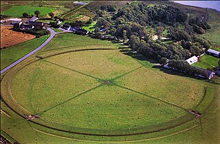
Aggersborg is the largest of Denmark's former Viking ring fortress, and one of the largest archaeological sites in Denmark. It is located near Aggersund on the north side of the Limfjord. It consists of a circular rampart surrounded by a ditch. Four main roads arranged in a cross connects the fortress center with the rampart's outer ring. The roads were tunneled under the outer rampart, leaving the circular structure intact. Many archaeological excavations have been conducted on the site, revealing its original structure and design. These excavations also uncovered a large number of artefacts from the Iron Age and Viking Age. The surface of the site as it exists today is a reconstruction.

<span class="mw-page-title-main">Trelleborg (Slagelse)</span> Viking ring castle in Denmark

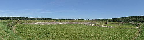
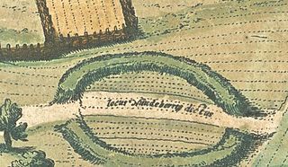
The Trelleborg, west of Slagelse on the Danish island of Zealand, is one of seven known Viking ring castles. When built, the fortress was situated on a peninsula that jutted into the swampy area between two rivers. The swamp was connected to the Great Belt by a lake and could be navigated by Viking ships. Trelleborg is believed to have been ordered by King Harald Bluetooth in the year 980 AD and it might have commanded the Great Belt and its sea traffic, between the islands of Zealand and Funen.

<span class="mw-page-title-main">Mead hall</span> Residence of a lord and his retainers in medieval Germanic Europe

Among the early Germanic peoples, a mead hall or feasting hall was a large building with a single room intended to receive guests and serve as a center of community social life. From the fifth century to the Early Middle Ages such a building was the residence of a lord or king and his retainers. These structures were also where lords could formally receive visitors and where the community would gather to socialize, allowing lords to oversee the social activity of their subjects.

<span class="mw-page-title-main">Circular rampart</span> Embankment built in the shape of a circle

A circular rampart is an embankment built in the shape of a circle that was used as part of the defences for a military fortification, hill fort or refuge, or was built for religious purposes or as a place of gathering.

<span class="mw-page-title-main">Medieval Scandinavian architecture</span>

The major aspects of Medieval Scandinavian architecture are boathouses, religious buildings, and general buildings.

<span class="mw-page-title-main">Heathen hof</span> Germanic pagan temple

A heathen hof or Germanic pagan temple is a temple building of Germanic religion. The term hof is taken from Old Norse.

<span class="mw-page-title-main">Buckland Rings</span> Iron Age hillfort in Hampshire, England

Buckland Rings is the site of an Iron Age hill fort in the town of Lymington, Hampshire. Today, the mounds and dykes around the outside which once constituted its defences are still clearly visible, although the outer bank lies under the road on the west side, and on the south-east it is nearly ploughed-out. Excavations of the inner and middle ramparts in 1935 revealed that they were of wall-and-fill construction, retained at the front by upright timber beams and walls of cut and laid turf. The entrance, which lies on the east side, was also excavated revealing a long entrance passage and the postholes for a pair of stout gateposts. The site was bought by Hampshire County Council in 1989 to ensure its preservation, and it is open to the public from the A337 road onto which part of it faces.

<span class="mw-page-title-main">Jelling stone ship</span>

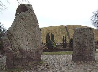
The Jelling stone ship is a stone ship, the longest known to have existed, remains of which lie under the two royal barrows at Jelling, Denmark.

<span class="mw-page-title-main">Firoz Shah palace complex</span> Archaeological site in India

Firoz Shah palace complex (Hisar-e-Firoza) is an archaeological complex located in modern-day Hisar, in the Haryana state of India, built by Firoz Shah Tughlaq of the Delhi Sultanate in 1354 AD. It is maintained by the Archaeological Survey of India.

<span class="mw-page-title-main">Late Antiquity and Medieval sites in Kosovo</span>

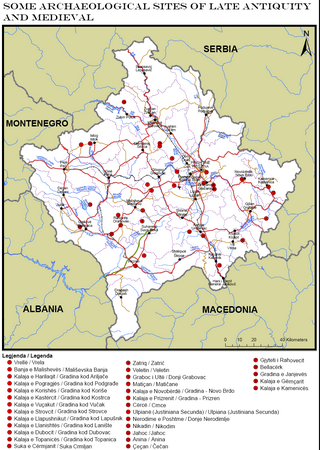
Part of series of articles upon Archaeology of Kosovo

The archaeological sites Randlev and Hesselbjerg refer to two closely related excavations done throughout the 20th century near the village of Randlev in the Odder Municipality of Denmark, three kilometers southeast of the town of Odder. Randlev is known primarily for its Romanesque church constructed sometime around 1100 A.D. Hesselbjerg refers to the large Viking-Age cemetery discovered on the Hesselbjerg family farm and the site Randlev refers to the nearby settlement from the same period. Although both Randlev and Hesselbjerg were contemporaneous and encompass a similar area, Hesselbjerg refers more specifically to the 104 graves discovered prior to the later excavation at the site Randlev, which pertains to the Viking Age settlement. The settlement consisted of a farm complex that was likely active during the ninth and tenth centuries; finds from the site such as silver hoards and elaborate jewelry indicate that the farm was likely prosperous, a conjecture which is supported by the extremely fertile land surrounding the area. Artifacts were found in the vicinity of the Hesselbjerg and Randlev sites as early as 1932 when a local farmer discovered a silver hoard, but serious excavations were not conducted until 1963. These excavations ended in 1970; however, Moesgård Museum returned to the site in 1997 and continued analysis until 2010.

<span class="mw-page-title-main">Borgring</span> Viking fortification in Denmark

Borgring also known as Vallø Borgring, is a Danish Viking ring fortress located near Køge on the island of Zealand. Likely built around 970 or 980, the fortress may have been built to defend trade routes or as a military barracks. In 2023, along with four other Viking ring fortresses, Borgring was isncribed on the UNESCO World Heritage List for its unique architecture and testimony to the strategic and military power of the House of Knýtlinga.

References

  1. Viking-Age Ring Fortresses, UNESCO World Heritage Centre, retrieved 24 January 2024 via whc.unesco.org
  2. Roesdahl, 1977, p. 188–189.
  3. Roesdahl, 1977, p. 189.
  4. Roesdahl, 1977, p. 190–193.
  5. Roesdahl, 1977.
  6. "Vikingecenter Fyrkat". The Historical Museum of Northern Jutland. Archived from the original on 2016-10-21. Retrieved 2014-03-04.
  7. "Vikingecenter Fyrkat" (in Danish). The Historical Museum of Northern Jutland.

56°37′24″N9°46′14″E / 56.62333°N 9.77056°E / 56.62333; 9.77056