Gardnerville Ranchos, Nevada

Last updated

Gardnerville Ranchos, Nevada
Douglas County Nevada Incorporated and Unincorporated areas Gardnerville Ranchos Highlighted.svg
Location of Gardnerville Ranchos, Nevada
Coordinates: 38°53′45″N119°44′4″W / 38.89583°N 119.73444°W / 38.89583; -119.73444
CountryUnited States
State Nevada
Area
[1]
  Total10.32 sq mi (26.74 km2)
  Land10.32 sq mi (26.74 km2)
  Water0.00 sq mi (0.00 km2)
Elevation
[2]
4,859 ft (1,481 m)
Population
 (2020)
  Total11,318
  Density1,096.17/sq mi (423.24/km2)
Time zone UTC−8 (Pacific (PST))
  Summer (DST) UTC−7 (PDT)
FIPS code 32-26500
GNIS feature ID1867346 [2]

Gardnerville Ranchos is a census-designated place in Douglas County, Nevada, United States. [2] As of the 2010 census, the population was 11,312. The area is the namesake for the Gardnerville Ranchos Micropolitan Statistical area which includes other areas of Douglas County.

Contents

Geography

According to the United States Census Bureau, the CDP has a total area of 14.7 square miles (38 km2), all of it land.

Climate

According to the Köppen climate classification, Gardnerville Ranchos has a warm-summer Mediterranean climate (abbreviated Csb).

Climate data for Gardnerville Ranchos, 1991–2020 simulated normals (4843 ft elevation)
MonthJanFebMarAprMayJunJulAugSepOctNovDecYear
Mean daily maximum °F (°C)47.5
(8.6)
51.1
(10.6)
57.6
(14.2)
62.4
(16.9)
71.1
(21.7)
81.3
(27.4)
90.1
(32.3)
89.4
(31.9)
82.4
(28.0)
70.9
(21.6)
57.0
(13.9)
46.6
(8.1)
67.3
(19.6)
Daily mean °F (°C)34.0
(1.1)
37.0
(2.8)
42.3
(5.7)
46.6
(8.1)
54.3
(12.4)
62.4
(16.9)
69.8
(21.0)
68.5
(20.3)
61.7
(16.5)
51.4
(10.8)
40.6
(4.8)
33.3
(0.7)
50.2
(10.1)
Mean daily minimum °F (°C)20.3
(−6.5)
23.0
(−5.0)
27.1
(−2.7)
30.7
(−0.7)
37.4
(3.0)
43.5
(6.4)
49.5
(9.7)
47.8
(8.8)
41.0
(5.0)
32.0
(0.0)
24.3
(−4.3)
19.9
(−6.7)
33.0
(0.6)
Average precipitation inches (mm)1.96
(49.66)
1.67
(42.46)
1.38
(35.05)
0.66
(16.83)
0.64
(16.32)
0.36
(9.22)
0.24
(5.97)
0.27
(6.76)
0.24
(6.11)
0.69
(17.43)
1.01
(25.78)
1.90
(48.36)
11.02
(279.95)
Average dew point °F (°C)20.8
(−6.2)
21.4
(−5.9)
22.6
(−5.2)
24.6
(−4.1)
30.4
(−0.9)
33.8
(1.0)
38.5
(3.6)
36.1
(2.3)
31.1
(−0.5)
25.9
(−3.4)
21.9
(−5.6)
19.9
(−6.7)
27.2
(−2.6)
Source: PRISM Climate Group [3]

Demographics

Historical population
CensusPop.Note
2020 11,318
U.S. Decennial Census [4]

As of the census [5] of 2000, there were 11,054 people, 4,003 households, and 3,146 families living in the CDP. The population density was 750.0 inhabitants per square mile (289.6/km2). There were 4,123 housing units at an average density of 279.7 per square mile (108.0/km2). The racial makeup of the CDP was 91.7% White, 0.3% African American, 2.2% Native American, 1.0% Asian, 0.1% Pacific Islander, 2.1% from other races, and 2.6% from two or more races. Hispanic or Latino of any race were 7.5% of the population.

There were 4,003 households, out of which 40.8% had children under the age of 18 living with them, 62.8% were married couples living together, 11.0% had a female householder with no husband present, and 21.4% were non-families. 15.9% of all households were made up of individuals, and 4.9% had someone living alone who was 65 years of age or older. The average household size was 2.75 and the average family size was 3.06.

In the CDP, the population was spread out, with 29.6% under the age of 18, 6.0% from 18 to 24, 29.0% from 25 to 44, 23.5% from 45 to 64, and 11.9% who were 65 years of age or older. The median age was 37 years. For every 100 females, there were 99.8 males. For every 100 females age 18 and over, there were 96.8 males.

The median income for a household in the CDP was $48,795, and the median income for a family was $51,546. Males had a median income of $37,292 versus $26,875 for females. The per capita income for the CDP was $20,856. About 6.4% of families and 7.2% of the population were below the poverty line, including 8.8% of those under age 18 and 3.0% of those age 65 or over.

Transportation

Transportation in Gardnerville Ranchos is provided by Douglas Area Rural Transit [6]

Related Research Articles

<span class="mw-page-title-main">Douglas County, Nevada</span> County in Nevada, United States

Douglas County is a county in the northwestern part of the U.S. state of Nevada. As of the 2020 census, the population was 49,488. Its county seat is Minden. Douglas County comprises the Gardnerville Ranchos, NV Micropolitan Statistical Area, which is also included in the Reno–Carson City–Fernley, NV Combined Statistical Area.

<span class="mw-page-title-main">Mountainaire, Arizona</span> CDP in Coconino County, Arizona

Mountainaire is a census-designated place (CDP) in Coconino County, Arizona, United States. The population was 1,119 at the 2010 census.

<span class="mw-page-title-main">East Rancho Dominguez, California</span> Unincorporated community in California, United States

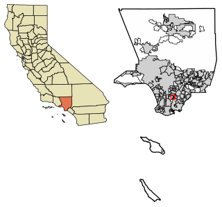
East Rancho Dominguez, also known as East Compton, is an unincorporated community and census-designated place (CDP) located in southern Los Angeles County, California. The population was 15,135 at the 2010 census, up from 9,286 at the 2000 census. East Rancho Dominguez is an accepted city name according to the USPS, and shares the 90221 ZIP Code with Compton.

<span class="mw-page-title-main">West Rancho Dominguez, California</span> Unincorporated community in California, United States

West Rancho Dominguez, formerly known as West Compton, is an unincorporated census-designated place (CDP) located in southern Los Angeles County, California. Per the 2020 census, the population was 24,347. The community lies to the west of the city of Compton. The ZIP Codes encompassing the CDP area are 90220 & 90248.

<span class="mw-page-title-main">San Lucas, California</span> Census-designated place in California, United States

San Lucas is an unincorporated community and census-designated place (CDP) in Monterey County, California, United States. It was founded in 1886 and named after the Rancho San Lucas, which was granted in 1842. The post office was first established in 1892.

<span class="mw-page-title-main">Las Flores, California</span> Census-designated place in California, United States

Las Flores is an unincorporated census-designated place (CDP) in Orange County, California, located adjacent to the City of Rancho Santa Margarita, California. The population was 5,971 at the 2010 census, up from 5,625 at the 2000 census. Las Flores does not have its own ZIP Code and is served by the same ZIP Code as adjacent Rancho Santa Margarita, 92688. The Rancho Santa Margarita dog/skate park is located in the CDP and is served by the Orange County Sheriff's Dept. and Orange County Fire Authority. Although Las Flores lies in the land grant of Rancho Mission Viejo, it is named after the land grant about 25 miles south Rancho Santa Margarita y Las Flores.

<span class="mw-page-title-main">Rancho Murieta, California</span> Census-designated place in California, United States

Rancho Murieta is a census-designated place (CDP) and guard-gated community in Sacramento County, California, United States. It is part of the Sacramento–Arden-Arcade–Roseville Metropolitan Statistical Area. The population was 5,488 at the 2010 census, up from 4,193 at the 2000 census. It is located in the foothills of the Sierra Nevada range, about 25 miles (40 km) east of Sacramento.

<span class="mw-page-title-main">Rancho Calaveras, California</span> Census-designated place in California, United States

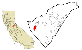
Rancho Calaveras is a census-designated place (CDP) in Calaveras County, California, United States. The population was 5,325 at the 2010 census, up from 4,182 at the 2000 census.

<span class="mw-page-title-main">Rancho San Diego, California</span> Census designated place in California, United States

Rancho San Diego is a census-designated place (CDP) in the East County region of San Diego County, California. The population was 21,858 at the 2020 census, up from 21,208 at the 2010 census. The area was developed as subdivisions beginning in the 1970s.

<span class="mw-page-title-main">Gardnerville, Nevada</span> Unincorporated town in the State of Nevada, United States

Gardnerville is an unincorporated town in Douglas County, Nevada, adjacent to the county seat of Minden. The population was 6,211 at the 2020 census.

<span class="mw-page-title-main">El Rancho, New Mexico</span> Census-designated place in New Mexico, United States

El Rancho is a census-designated place (CDP) in Santa Fe County, New Mexico, United States. It is part of the Santa Fe, New Mexico Metropolitan Statistical Area. The population was 1,199 at the 2010 census.

<span class="mw-page-title-main">Ranchos de Taos, New Mexico</span> Census-designated place in Taos County, New Mexico, United States

Ranchos de Taos is a census-designated place (CDP) in Taos County, New Mexico. The population was 2,390 at the time of the 2000 census.

<span class="mw-page-title-main">Aquebogue, New York</span> Hamlet and census-designated place in New York, United States

Aquebogue is a census-designated place (CDP) roughly corresponding to the hamlet by the same name in the Town of Riverhead in Suffolk County, on Long Island, in New York, United States. The CDP's population was 2,438 at the 2010 census.

<span class="mw-page-title-main">Winchester Bay, Oregon</span> Unincorporated community in the state of Oregon, United States

Winchester Bay, formerly Umpqua City, is an unincorporated community in Douglas County, Oregon, United States. For statistical purposes, the United States Census Bureau has defined Winchester Bay as a census-designated place (CDP). The census definition of the area may not precisely correspond to local understanding of the area with the same name. The population of the CDP was 382 at the 2010 census. The community of Umpqua City was established in 1850.

<span class="mw-page-title-main">Skyline View, Pennsylvania</span> Census-designated place in Pennsylvania, United States

Skyline View is an unincorporated community and census-designated place (CDP) in West Hanover Township, Dauphin County, Pennsylvania, United States. The population was 4,003 at the 2010 census, up from 2,307 at the 2000 census. It is part of the Harrisburg–Carlisle Metropolitan Statistical Area.

<span class="mw-page-title-main">Olmito, Texas</span> Census-designated place in Texas, United States

Olmito is a census-designated place (CDP) in Cameron County, Texas, United States. Olmito is Spanish for "little elm". The population was 1,210 at the 2010 census. It is part of the Brownsville–Harlingen Metropolitan Statistical Area. Olmito is the self-described "mesquite capital of the world."

<span class="mw-page-title-main">Redwood, Texas</span> Unincorporated community in Texas, United States

Redwood is an unincorporated community and census-designated place (CDP) in Guadalupe County, Texas, United States. The population was 4,003 at the 2020 census, down from 4,338 at the 2010 census. It is part of the San Antonio Metropolitan Statistical Area.

<span class="mw-page-title-main">Rancho Alegre, Texas</span> Census-designated place in Texas, United States

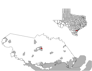
Rancho Alegre is an unincorporated area and census-designated place (CDP) in Jim Wells County, Texas, United States. The population was 1,704 at the 2010 census.

<span class="mw-page-title-main">Rancho Chico, Texas</span> CDP in Texas, United States

Rancho Chico is a census-designated place (CDP) in San Patricio County, Texas, United States. The population was 396 at the 2010 census.

<span class="mw-page-title-main">Ranchos Penitas West, Texas</span> CDP in Texas, United States

Ranchos Penitas West is a census-designated place (CDP) in Webb County, Texas, United States. The population was 573 at the 2010 census.

References

  1. "ArcGIS REST Services Directory". United States Census Bureau. Retrieved September 19, 2022.
  2. 1 2 3 U.S. Geological Survey Geographic Names Information System: Gardnerville Ranchos, Nevada
  3. "PRISM Climate Group at Oregon State University". Northwest Alliance for Computational Science & Engineering (NACSE), based at Oregon State University. Retrieved March 16, 2023.
  4. "Census of Population and Housing". Census.gov. Retrieved June 4, 2016.
  5. "U.S. Census website". United States Census Bureau . Retrieved January 31, 2008.
  6. "DART". communityservices.douglascountynv.gov.