
Southam is a market town and civil parish in the Stratford-on-Avon district of Warwickshire, England. Southam is situated on the River Stowe, which flows from Napton-on-the-Hill and joins Warwickshire's River Itchen at Stoneythorpe, just outside the town.

The A41 is a trunk road between London and Birkenhead, England. Now in parts replaced by motorways, it passes through or near Watford, Kings Langley, Hemel Hempstead, Aylesbury, Bicester, Solihull, Birmingham, West Bromwich, Wolverhampton, Newport, Whitchurch, Chester and Ellesmere Port.

The M40 motorway links London, Oxford, and Birmingham in England, a distance of approximately 89 miles (143 km).
Silverstone is a village and civil parish in Northamptonshire, England. It is about 4 miles (6.4 km) from Towcester on the former A43 main road, 10 miles (16 km) from the M1 motorway junction 15A and about 12 miles (19 km) from the M40 motorway junction 10, Northampton, Milton Keynes and Banbury. The population of the civil parish at the 2011 census was 2,176. The A43 now bypasses to the south-east of the village.

Kineton is a village and civil parish on the River Dene in south-east Warwickshire, England. The village is part of Stratford-on-Avon district, and in the 2001 census it had a population of 2,278, increasing to 2,337 at the 2011 Census.
Castle Bromwich is a large suburban village and civil parish in the Metropolitan Borough of Solihull in the West Midlands, England. It borders the rest of the borough to the south east, Sutton Coldfield to the east and north east, Shard End to the south west, Castle Vale, Erdington and Minworth to the north and Hodge Hill to the west.

Steeple Aston is a village and civil parish on the edge of the Cherwell Valley, in the Cherwell District of Oxfordshire, England, about 12 miles (19 km) north of Oxford, 7 miles (11 km) west of Bicester, and 10 miles (16 km) south of Banbury. The 2011 Census recorded the parish population as 947. The village is 108 metres (354 ft) above sea level. The River Cherwell and Oxford Canal pass 1 mile (2 km) east of the village. The river forms part of the eastern boundary of the parish. The parish's southern boundary, 1⁄2 mile (800 m) south of the village, also forms part of Cherwell District's boundary with West Oxfordshire.

The A43 is a primary route in the English Midlands and northern South East England, that runs from the M40 motorway near Ardley in Oxfordshire to Stamford in Lincolnshire. Through Northamptonshire it bypasses the towns of Northampton, Kettering and Corby which are the three principal destinations on the A43 route. The A43 also links to the M1 motorway.
Warmington is a village and civil parish in the Stratford-on-Avon district of Warwickshire, England. It is located on the border with Oxfordshire, around 5 miles (8 km) northwest of Banbury. The civil parish had, according to the 2001 Census a population of 297 increasing to 304 at the 2011 Census. The parish also includes Arlescote and the council is called Warmington & Arlescote. The National Herb Centre is found just outside the village.

Bishop's Itchington is a village and civil parish in the Stratford-on-Avon district of Warwickshire, England. It is about 3 miles (5 km) south-southwest of Southam and about 6.5 miles (10 km) southeast of Royal Leamington Spa. The 2011 Census recorded the parish's population as 2,082.

Long Itchington is a large village and civil parish in Warwickshire, England, which at the 2011 Census had a population of 2,013. The village is named after the River Itchen which flows to the south and west of the village. Long Itchington is around two miles north of Southam on the A423 road, just north of the Grand Union Canal.

Harbury is a village and civil parish in the Stratford-on-Avon district of Warwickshire, England. It is about 3 miles (5 km) west-southwest of Southam and about 5 miles (8 km) southeast of Royal Leamington Spa. The parish includes the hamlet of Deppers Bridge. The 2011 Census recorded the parish's population as 2,420. The village is on a ridge of lias up to 390 feet (119 m) high that runs roughly northeast – southwest. The parish covers 3,397 acres (1,375 ha). It is bounded by the River Itchen to the east, Fosse Way to the northwest, a minor road to the south and field boundaries on its other sides. Adjoining parishes are Bishop's Itchington, Bishop's Tachbrook, Chesterton, Ladbroke and Southam. The A425 road and the Chiltern Main Line pass through the parish just north of Harbury village. Junction 12 on the M40 motorway is about 3 miles (5 km) south of the village.

The British Motor Museum in Gaydon, Warwickshire, England holds the world's largest collection of historic British cars, with over 300 cars on display from the British Motor Industry Heritage Trust and the Jaguar Heritage Trust.

The A423 road is a primary A road in England in two sections. The main section leads from central Banbury to the A45 near Coventry.
Lewknor is a village and civil parish about 5 miles (8 km) south of Thame in Oxfordshire. The civil parish includes the villages of Postcombe and South Weston. The 2011 Census recorded the parish's population as 663.

Lighthorne Heath is a village in the civil parish of Upper Lighthorne, in the Stratford-on-Avon District, in the county of Warwickshire, England. It is located some six miles to the south east of Leamington Spa and is very close to the M40 motorway.

Defence Munitions (DM) Kineton occupies the site officially known as MOD Kineton, and is a Ministry of Defence property located close to the village of Kineton, Warwickshire, England.
The M40 corridor is the area adjacent to the M40 motorway running through England. It is one of the main routes between London and Birmingham, the other being that followed by the M1 motorway.
Shotteswell is a village and civil parish in the Stratford-on-Avon district of Warwickshire. The population of the civil parish at the 2011 census was 221. The parish is bounded on three sides by Oxfordshire and is about 4 miles (6 km) north-west of Banbury.
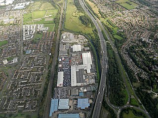
The Jaguar Land Rover Gaydon Centre, which is situated north-west of the village of Gaydon, Warwickshire, England, is one of the principal engineering centres of Jaguar Land Rover and the location of the headquarters of Land Rover. The site houses a design, research and development centre and extensive test track facilities and is used for the design and development of Jaguar and Land Rover vehicles. The site, along with the smaller Aston Martin facility adjacent, occupies the land that was once the RAF V bomber base of RAF Gaydon. The British Motor Museum is also located on the same site.

