Geoconservation

Last updated

Geoconservation is the practice of recognising, protecting and managing sites and landscapes which have value for their geology or geomorphology. [1] [2] The conservation of these geological sites is through government agencies and local geological societies in areas such as Europe and Africa. [3] [4] [5] [6] The designation of these sites is done through an analysis of the site, and the production of proper management infrastructure. The principles of geoconservation are to create a means of protection for the sites, and assess their value to the geological community. [7] [8] [9] [10] [11] Typically the conservation of geodiversity at a site or within a landscape takes place alongside that of biodiversity.

Contents

In European countries

The state of geoconservation legislation in 37 countries in Europe was described by specialists in each country and published in Geoheritage in Europe and its conservation in 2012 by ProGEO (The European Association for the Conservation of the Geological Heritage, now, in 2023, the International Association for the Conservation of Geological Heritage). [12]

In the UK

In the late 1970s, the former Nature Conservancy Council initiated the Geological Conservation Review (GCR), a comprehensive assessment of the key geological and geomorphological sites within England, Scotland and Wales, a task which was largely completed by 1990. Over 3000 sites across Britain were identified and many are now designated as sites of special scientific interest (SSSIs), thus providing them with statutory protection. These geological SSSIs are now managed by the respective country nature conservation bodies; Natural England, NatureScot and Natural Resources Wales. A similar approach has been taken in Northern Ireland with the Earth Science Conservation Review (ESCR). [13]

Many thousands of geosites across Great Britain are given protection at a level below that afforded by SSSI status. Originally referred to as regionally important geological sites, the term 'Local Geological Sites' (or LoGS) is now in use for them in England and 'Local Geodiversity Sites' in Scotland, whilst in Wales, they are referred to as 'Regionally Important Geodiversity Sites' (or RIGS). Numerous local groups have been established to protect and conserve these sites, all coming under the 'umbrella organisation', GeoConservationUK. [14]

Principles and protected areas

The principles of geoconservation are to create an inventory of geoheritage sites, create an assessment of their value, manage their conservation, monitor the geoconserved sites and promote the sites through interpretation. [7] [8] The geoconserved sites can be added to the inventory by field specialists who observe the site through surveying, mapping and field work. The site will be documented with the non-specialist landowners, rangers and protected area managers. [7]

The main objective of geoconservation is to protect the area that is to be conserved. This is done by assessing the value of the geological structures and composition of the site. The value of the site is based on the cultural and aesthetic value, the value for geotourism and biodiversity conservation. [9] [10] The geomorphological sites to be conserved can be static features such as relict glacial landforms, or active features such as coastal and river landforms. An assessment of the management of the site can provide an idea of how to protect the site and to how the conservation of the site will be maintained. [9] The management of the site should include how suitable the area is to be a site of geotourism. [10] The management plan will give the practicality of the site, and will be used to assess how the site can be taken care of.

The geosites are zoned to provide proper management of the protected areas. The core areas are the places in the geoheritage site that are the most important for protection, and require the higher amounts of infrastructure. The buffer areas is the zone around the core areas that will support the core zone and be used for a wider range of activities. To maintain the protection and structure of the geoconservation area, site condition monitoring is performed to ensure this. Site condition monitoring is the assessment of the protocols that were set for the site, and an assessment to see if the conservation objectives are being met. [11] Regularly scheduled assessment of the site can ensure the proper management and conservation of the site.

In Africa

M'Goun Area in Morocco Ighil M'Goun vu depuis Arous.jpg
M'Goun Area in Morocco
Ngorongoro Lengai Area in Tanzania Lengai and Lava, Ngorongoro District.jpg
Ngorongoro Lengai Area in Tanzania

The African continent has many sites that are in the process of becoming geoconserved sites. Africa shows many areas that are of geoheritage value, and these sites show different types of geoheritage value. [3] Many of the sites that are in the process of having geoconserved stars are along the coast of the continent, and in the southern and northern edges. The Geosciences and Geoparks Programme in the Natural Science Sector, has two geoparks listed for protection in Africa. There is the M'Goun UGGp in Morocco and the Ngorongoro Lengai UGGp in Tanzania. [3] These two geoparks only represent 1% of the available geosites that are listed as areas of needed conservation in Africa based on the World Heritage Sites under UNESCO. [3] Many of the available geoheritage sites in Africa do not have the government infrastructure to provide the necessary management and protection of the areas. [4]

An area in South Angola has been proposed as having a community-based protection of geoheritage sites. The Tudavala and Leba geosites are not under any current protection, but have recently been classified as an important cultural landscape by the government of Angola. [5] The proposed conservation model is to use the local community to conserve the area and help with protecting the geoheritage sites, instead of government based management. [5] A geosite in Madagascar is being used to test the ability of protection in geoparks through the infrastructure of Madagascar. Isalo Park is the pilot site that shows valuable geoheritage for the country of Madagascar, and with proper management can become a geoconserved site in the future. [6]

See also

Related Research Articles

<span class="mw-page-title-main">Protected areas of the United Kingdom</span> Designated area for protection in the United Kingdom

Protected areas of the United Kingdom are areas in the United Kingdom which need and /or receive protection because of their environmental, historical or cultural value to the nation. Methods and aims of protection vary depending on the nature and importance of the resource. Protection operates at local, regional, national and international levels, and may be backed by legislation and international treaty, or less formally by planning policy.

<span class="mw-page-title-main">Geopark</span> Internationally protected area that advances the use of geological heritage in a sustainable way

A geopark is a protected area with internationally significant geology within which sustainable development is sought and which includes tourism, conservation, education and research concerning not just geology but other relevant sciences.

Site of Nature Conservation Interest (SNCI), Site of Importance for Nature Conservation (SINC) and regionally important geological site (RIGS) are designations used by local authorities in the United Kingdom for sites of substantive local nature conservation and geological value. The Department for Environment, Food and Rural Affairs has recommended the generic term 'local site', which is divided into 'local wildlife site' and 'local geological site'.

<span class="mw-page-title-main">Geodiversity</span>

Geodiversity is the variety of earth materials, forms and processes that constitute and shape the Earth, either the whole or a specific part of it. Relevant materials include minerals, rocks, sediments, fossils, soils and water. Forms may comprise folds, faults, landforms and other expressions of morphology or relations between units of earth material. Any natural process that continues to act upon, maintain or modify either material or form represents another aspect of geodiversity. However geodiversity is not normally defined to include the likes of landscaping, concrete or other significant human influence.

<span class="mw-page-title-main">Lesvos Petrified Forest</span> Petrified wood forest found on the island of Lesbos, Greece

The Lesvos Petrified Forest is a petrified wood forest on the island of Lesbos, Greece.

<span class="mw-page-title-main">Geotourism</span> Tourism associated with geological attractions and destinations

Geotourism is tourism associated with geological attractions and destinations. Geotourism deals with the abiotic natural and built environments. Geotourism was first defined in England by Thomas Alfred Hose in 1995.

<span class="mw-page-title-main">Lumangwe Falls</span> Waterfall in Zambia

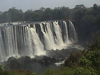
Lumangwe Falls on the Kalungwishi River in northern Zambia is the largest waterfall wholly within the country, with a height of 30-40 m and a width of 100-160 m. It is a block-type waterfall located between the Luapula and Northern Provinces. The main bedrock is interbedded quartzite with layers of red siltstone.

Regionally important geological and geomorphological sites (RIGS) are locally designated sites of local, national and regional importance for geodiversity in the United Kingdom and Isle of Man. These sites are also known by other names, such as regionally important geological sites, Regionally Important Geodiversity Sites, County Geodiversity Sites in Norfolk, Local Geodiversity Sites in Scotland and Lancashire, and as County Geology Sites in Cornwall and Devon and in the Republic of Ireland.

<span class="mw-page-title-main">UNESCO Global Geoparks</span> Geoparks certified by the UNESCO Global Geoparks Council

UNESCO Global Geoparks (UGGp) are geoparks certified by the UNESCO Global Geoparks Council as meeting all the requirements for belonging to the Global Geoparks Network (GGN). The GGN is both a network of geoparks and the agency of the United Nations Educational, Scientific and Cultural Organization (UNESCO). that administers the network.

Natural Heritage Area is a conservation designation denoting a protected area in Ireland. The Wildlife (Amendment) Act 2000 makes legal provision for the designation and protection of a national network of Natural Heritage Areas (NHAs).

Geoheritage is the geological aspect of natural and cultural heritage. A geosite is a particular geological heritage asset. It is a heritage category comparable to other forms of natural heritage, such as biodiversity.

<span class="mw-page-title-main">San'in Kaigan Geopark</span>

The San'in Kaigan Geopark (山陰海岸ジオパーク) is a geopark in Japan. The area was declared a Japanese Geopark in 2008, and a UNESCO Global Geopark in 2010. The underlying themes of the geopark are "geological features, the natural environment, people's lives, and the formation of the Sea of Japan". This geologically diverse area contains records of the process from when Japan was part of the Asian continent to its present-day formation of the Sea of Japan. People's lives are also diverse in this area because of its geodiversity.

<span class="mw-page-title-main">Azores Geopark</span>

The Azores Geopark is a network of 121 geographically-dispersed sites of geographic heritage and marine areas that covers the nine volcanic islands of the archipelago of the Azores. This network is managed by the Azores Geopark Association, a non-profit association, with its headquarters in Horta on the island of Faial, established 19 May 2010. It is part of the European Geoparks Network and the UNESCO Global Geoparks Network. The Association's mission is to ensure the geological conservation, environmental education and sustainable development, while promoting the well-being of the population and a respect for the environment.

<span class="mw-page-title-main">Asia Pacific Geoparks Network</span> A regional network of Geoparks.

The Asia Pacific Geoparks Network (APGN) is the regional geopark network of the Global Geoparks Network (GGN) and the UNESCO International Geosciences and Geoparks Programme (UNESCO-IGGP). Its main role is to coordinate the activities of GGN in the UNESCO regions of Asia and the Pacific, to promote networking between global geoparks and geopark professionals in the region and to provide support for sustainable economic development in geopark areas. As of 2020 February, the APGN had 60 institutional members in countries. The Pacific region is currently not represented by a global geopark, but there are ongoing geopark projects, just as in other countries of Asia.

<span class="mw-page-title-main">Haddinnet</span> Municipality in Tigray Region, Ethiopia

Haddinnet, also transliterated as Hadnet, is a tabia or municipality in the Dogu'a Tembien district of the Tigray Region of Ethiopia. The tabia centre is in Addi Idaga village, located approximately 6.5 km to the northeast of the woreda town Hagere Selam.

Cynthia Veronica Burek is a Professor of Geoconservation at the University of Chester. She serves on the steering group of the Geodiversity Action Plan (UKGAP) and as a Director of the British Federation of Women Graduates.

<span class="mw-page-title-main">Geomorphosite</span> Landform of scientific or social value

A geomorphosite, or geomorphological heritage site, is a landform or an assemblage of landforms that have a scientific, educational, historic-cultural, aesthetic or socio-economic value.

The Brymbo Fossil Forest is a palaeobotanical site near Brymbo, Wrexham County Borough, Wales. It is known as a significant area of Early Carboniferous fossils, and is a Site of Special Scientific Interest.

References

  1. "Geoconservation and Geodiversity". Edinburgh Geological Society. Retrieved 2023-04-19.
  2. Burek, C. V.; Prosser, C. D. (January 2008). "The history of geoconservation: an introduction". Geological Society, London, Special Publications. 300 (1): 1–5. doi:10.1144/SP300.1. ISSN   0305-8719. S2CID   42483789.
  3. 1 2 3 4 Neto, K.; Henriques, M. H. (2022-10-01). "Geoconservation in Africa: State of the art and future challenges". Gondwana Research. 110: 107–113. doi: 10.1016/j.gr.2022.05.022 . hdl: 10316/100833 . ISSN   1342-937X. S2CID   249977369.
  4. 1 2 Reimold, Wolf Uwe (1999-10-01). "Geoconservation - a southern African and African perspective". Journal of African Earth Sciences. 29 (3): 469–483. doi:10.1016/S0899-5362(99)00110-4. ISSN   1464-343X.
  5. 1 2 3 Tavares, Alexandre Oliveira; Henriques, Maria Helena; Domingos, Artur; Bala, Abel (May 2015). "Community Involvement in Geoconservation: A Conceptual Approach Based on the Geoheritage of South Angola". Sustainability. 7 (5): 4893–4918. doi: 10.3390/su7054893 . hdl: 10316/36576 . ISSN   2071-1050.
  6. 1 2 Raharimahefa, T. (2013). "Geoconservation and geodiversity for sustainable development in Madagascar". Madagascar Conservation & Development. 7 (3). doi: 10.4314/MCD.V7I3.5 . S2CID   129774561.
  7. 1 2 3 Gordon, John E. (2019-12-01). "Geoconservation principles and protected area management". International Journal of Geoheritage and Parks. 7 (4): 199–210. doi:10.1016/j.ijgeop.2019.12.005. hdl: 10023/19450 . ISSN   2577-4441. S2CID   212957142.
  8. 1 2 Brilha, José (2016-06-01). "Inventory and Quantitative Assessment of Geosites and Geodiversity Sites: a Review". Geoheritage. 8 (2): 119–134. doi:10.1007/s12371-014-0139-3. hdl: 1822/32896 . ISSN   1867-2485. S2CID   55232122.
  9. 1 2 3 Prosser, Colin D.; Díaz-Martínez, Enrique; Larwood, Jonathan G. (2018-01-01), Reynard, Emmanuel; Brilha, José (eds.), "Chapter 11 - The Conservation of Geosites: Principles and Practice", Geoheritage, Elsevier, pp. 193–212, ISBN   978-0-12-809531-7 , retrieved 2023-04-12
  10. 1 2 3 Brilha, José (September 2002). "Geoconservation and protected areas". Environmental Conservation. 29 (3): 273–276. doi:10.1017/S0376892902000188. hdl: 1822/1247 . ISSN   1469-4387. S2CID   129425938.
  11. 1 2 Crofts, Roger (2014-07-01). "Promoting geodiversity: learning lessons from biodiversity". Proceedings of the Geologists' Association. 125 (3): 263–266. doi:10.1016/j.pgeola.2014.03.002. ISSN   0016-7878.
  12. W.A.P.Wimbledon; S.Smith-Meyer, eds. (2012). Geoheritage in Europe and its conservation. ProGEO. ISBN   978-82-426-2476-5.
  13. "Geological conservation". JNCC. Retrieved 15 May 2021.
  14. "About". GeoConservationUK. 11 February 2019. Retrieved 18 May 2021.