Geodesy is the science of measuring and representing the geometry, gravity, and spatial orientation of the Earth in temporally varying 3D. It is called planetary geodesy when studying other astronomical bodies, such as planets or circumplanetary systems.

Surveying or land surveying is the technique, profession, art, and science of determining the terrestrial two-dimensional or three-dimensional positions of points and the distances and angles between them. These points are usually on the surface of the Earth, and they are often used to establish maps and boundaries for ownership, locations, such as the designed positions of structural components for construction or the surface location of subsurface features, or other purposes required by government or civil law, such as property sales.

The World Geodetic System (WGS) is a standard used in cartography, geodesy, and satellite navigation including GPS. The current version, WGS 84, defines an Earth-centered, Earth-fixed coordinate system and a geodetic datum, and also describes the associated Earth Gravitational Model (EGM) and World Magnetic Model (WMM). The standard is published and maintained by the United States National Geospatial-Intelligence Agency.

The National Geodetic Survey (NGS) is a United States federal agency based in Washington, D.C. that defines and manages a national coordinate system, providing the foundation for transportation and communication, mapping and charting, and a large number of science and engineering applications. Since its founding in 1970, it has been part of the National Oceanic and Atmospheric Administration (NOAA), a division within the United States Department of Commerce.
A geodetic datum or geodetic system is a global datum reference or reference frame for precisely representing the position of locations on Earth or other planetary bodies by means of geodetic coordinates. Datums are crucial to any technology or technique based on spatial location, including geodesy, navigation, surveying, geographic information systems, remote sensing, and cartography. A horizontal datum is used to measure a location across the Earth's surface, in latitude and longitude or another coordinate system; a vertical datum is used to measure the elevation or depth relative to a standard origin, such as mean sea level (MSL). Since the rise of the global positioning system (GPS), the ellipsoid and datum WGS 84 it uses has supplanted most others in many applications. The WGS 84 is intended for global use, unlike most earlier datums.

The Meades Ranch Triangulation Station is a survey marker in Osborne County in the state of Kansas in the Midwestern United States. The marker was initially placed in 1891. From 1901, it was the reference location for establishing a system of horizontal measurement in the United States, known as geodetic datum. In 1913, the datum was adopted across all of North America, and the system revised and formalized as the North American Datum of 1927 (NAD27). A similar reference for vertical measurement was established in 1929 as the National Geodetic Vertical Datum of 1929. The NAD27 was later supplanted by the North American Datum of 1983 (NAD83), which was formally adopted by the United States in 1989 and Canada in 1990; the new system moved the reference point to a point in the Earth's core, and the Meades Ranch marker lost its special significance to the geodetic datum system.

Satellite geodesy is geodesy by means of artificial satellites—the measurement of the form and dimensions of Earth, the location of objects on its surface and the figure of the Earth's gravity field by means of artificial satellite techniques. It belongs to the broader field of space geodesy. Traditional astronomical geodesy is not commonly considered a part of satellite geodesy, although there is considerable overlap between the techniques.

Arc measurement, sometimes degree measurement, is the astrogeodetic technique of determining the radius of Earth – more specifically, the local Earth radius of curvature of the figure of the Earth – by relating the latitude difference and the geographic distance surveyed between two locations on Earth's surface. The most common variant involves only astronomical latitudes and the meridian arc length and is called meridian arc measurement; other variants may involve only astronomical longitude or both geographic coordinates . Arc measurement campaigns in Europe were the precursors to the International Association of Geodesy (IAG).
Geodetic astronomy or astronomical geodesy (astro-geodesy) is the application of astronomical methods into geodetic networks and other technical projects of geodesy.
A spatial reference system (SRS) or coordinate reference system (CRS) is a framework used to precisely measure locations on the surface of Earth as coordinates. It is thus the application of the abstract mathematics of coordinate systems and analytic geometry to geographic space. A particular SRS specification comprises a choice of Earth ellipsoid, horizontal datum, map projection, origin point, and unit of measure. Thousands of coordinate systems have been specified for use around the world or in specific regions and for various purposes, necessitating transformations between different SRS.
The North American Datum (NAD) is the horizontal datum now used to define the geodetic network in North America. A datum is a formal description of the shape of the Earth along with an "anchor" point for the coordinate system. In surveying, cartography, and land-use planning, two North American Datums are in use for making lateral or "horizontal" measurements: the North American Datum of 1927 (NAD 27) and the North American Datum of 1983 (NAD 83). Both are geodetic reference systems based on slightly different assumptions and measurements.

The Earth-centered, Earth-fixed coordinate system, also known as the geocentric coordinate system, is a cartesian spatial reference system that represents locations in the vicinity of the Earth as X, Y, and Z measurements from its center of mass. Its most common use is in tracking the orbits of satellites and in satellite navigation systems for measuring locations on the surface of the Earth, but it is also used in applications such as tracking crustal motion.
Stellar triangulation is a method of geodesy and of its subdiscipline space geodesy used to measure Earth's geometric shape. Stars were first used for this purpose by the Finnish astronomer Yrjö Väisälä in 1959, who made astrometric photographs of the night sky at two stations together with a lighted balloon probe between them.
The North American Vertical Datum of 1988 is the vertical datum for orthometric heights established for vertical control surveying in the United States of America based upon the General Adjustment of the North American Datum of 1988.
An Earth ellipsoid or Earth spheroid is a mathematical figure approximating the Earth's form, used as a reference frame for computations in geodesy, astronomy, and the geosciences. Various different ellipsoids have been used as approximations.

The National Spatial Reference System (NSRS), managed by the National Geodetic Survey (NGS), is a coordinate system that includes latitude, longitude, elevation, and other values. The NSRS consists of a National Shoreline, the NOAA CORS Network, a network of permanently marked points, and a set of models that describe dynamic geophysical processes affecting spatial measurements. The system is based on the datums NAD 83 and NAVD 88.
The Hellenic Geodetic Reference System 1987 or HGRS87 is a geodetic system commonly used in Greece (SRID=2100). The system specifies a local geodetic datum and a projection system. In some documents it is called Greek Geodetic Reference System 1987 or GGRS87.
The IERS Reference Meridian (IRM), also called the International Reference Meridian, is the prime meridian maintained by the International Earth Rotation and Reference Systems Service (IERS). It passes about 5.3 arcseconds east of George Biddell Airy's 1851 transit circle which is 102 metres (335 ft) at the latitude of the Royal Observatory, Greenwich. Thus it differs slightly from the historical Greenwich Meridian.

The Geodetic Observatory Wettzell is located atop the 616 meter-high mountain Wagnerberg, west of the village Wettzell in the German district Cham in the Bavarian Forest.

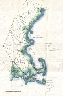
The Transcontinental Traverse (TCT) was a geodetic survey traverse conducted in the continental United States by the United States Coast and Geodetic Survey between 1961 and 1970 and the U.S. National Geodetic Survey between 1970 and 1976. It was the most accurate large-area survey ever done prior to Global Positioning System surveys. TCT included over 2,700 survey stations, covered over 13,600 miles (21,900 km), and passed through 44 U.S. states.