The U.S. state of Idaho borders six other U.S. states and one Canadian province. The states of Washington and Oregon are to the west, Nevada and Utah are to the south, and Montana and Wyoming are to the east. Idaho also shares a short border with the Canadian province of British Columbia to the north.
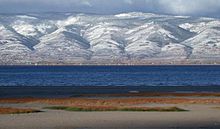
The landscape is rugged, with some of the largest unspoiled natural areas in the United States. For example, at 2.3 million acres (930,000 ha), the Frank Church-River of No Return Wilderness Area is the largest contiguous area of protected wilderness in the continental United States. Idaho is a Rocky Mountain state with abundant natural resources and scenic areas. The state has snow-capped mountain ranges, rapids, vast lakes and steep canyons. The waters of the Snake River run through Hells Canyon, the deepest gorge in the United States. Shoshone Falls falls down cliffs from a height greater than Niagara Falls.
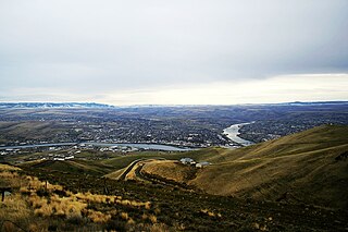
By far, the most important river in Idaho is the Snake River, a major tributary of the Columbia River. The Snake River flows out from Yellowstone in northwestern Wyoming through the Snake River Plain in southern Idaho before turning north, leaving the state at Lewiston before joining the Columbia in Kennewick. Other major rivers are the Clark Fork/Pend Oreille River, the Spokane River, and, many major tributaries of the Snake River, including the Clearwater River, the Salmon River, the Boise River, and the Payette River. The Salmon River empties into the Snake in Hells Canyon and forms the southern boundary of Nez Perce County on its north shore, of which Lewiston is the county seat. The Port of Lewiston, at the confluence of the Clearwater and the Snake Rivers is the farthest inland seaport on the West Coast at 465 river miles from the Pacific at Astoria, Oregon. [1]
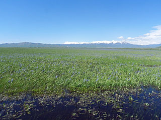
The vast majority of Idaho's population lives in the Snake River Plain, a valley running from across the entirety of southern Idaho from east to west. The valley contains the major cities of Boise, Meridian, Nampa, Caldwell, Twin Falls, Idaho Falls, and Pocatello. The plain served as an easy pass through the Rocky Mountains for westward-bound settlers on the Oregon Trail, and many settlers chose to settle the area rather than risking the treacherous route through the Blue Mountains and the Cascade Range to the west. The western region of the plain is known as the Treasure Valley, bound between the Owyhee Mountains to the southwest and the Boise Mountains to the northeast. The central region of the Snake River Plain is known as the Magic Valley.
Idaho's highest point is Borah Peak, 12,662 ft (3,859 m), in the Lost River Range north of Mackay. In 1983, an earthquake there caused two fatalities. [2] [3] Idaho's lowest point, 710 ft (216 m), is in Lewiston, where the Clearwater River joins the Snake River and continues into Washington. The Sawtooth Range is often considered Idaho's most famous mountain range. [4] Other mountain ranges in Idaho include the Bitterroot Range, the White Cloud Mountains, the Lost River Range, the Clearwater Mountains, and the Salmon River Mountains. The only active glacier in Idaho is at Borah Peak. [5]
Salmon-Challis National Forest is located in the east central sections of the state, with Salmon National Forest to the north and Challis National Forest to the south. The forest is in an area known as the Idaho Cobalt Belt, which consists of a 34 miles (55 km) long geological formation of sedimentary rock that contains some of the largest cobalt deposits in the U.S. [6]
Idaho has two time zones, with the dividing line approximately midway between Canada and Nevada. Southern Idaho, including the Boise metropolitan area, Idaho Falls, Pocatello, and Twin Falls, are in the Mountain Time Zone. A legislative error (15 U.S.C. ch. 6 §264) theoretically placed this region in the Central Time Zone, but this was corrected with a 2007 amendment. [7] Areas north of the Salmon River, including Coeur d'Alene, Moscow, Lewiston, and Sandpoint, are in the Pacific Time Zone, which contains less than a quarter of the state's population and land area.
Idaho's climate varies widely. Although the state's western border is about 330 miles (530 km) from the Pacific Ocean, the maritime influence is still felt in Idaho; especially, in the winter when cloud cover, humidity, and precipitation are at their maximum extent. This influence has a moderating effect in the winter where temperatures are not as low as would otherwise be expected for a northern state with predominantly high elevations. [8] In the panhandle, moist air masses from the coast are released as precipitation over the North Central Rockies forests, creating the North American inland temperate rainforest. [9] The maritime influence is least prominent in the state's eastern part where the precipitation patterns are often reversed, with wetter summers and drier winters, and seasonal temperature differences are more extreme, showing a more semi-arid continental climate. [10]
Idaho can be hot, although extended periods over 98 °F (37 °C) are rare, except for the lowest point in elevation, Lewiston, which correspondingly sees little snow. Boise receives around 18 inches (46 cm) of snow annually. [11] Hot summer days are tempered by the low relative humidity and cooler evenings during summer months since, for most of the state, the highest diurnal difference in temperature is often in the summer. [12] Winters can be cold, although extended periods of bitter cold weather below zero are unusual. Idaho's all-time highest temperature of 118 °F (48 °C) was recorded at Orofino on July 28, 1934; [13] [14] the all-time lowest temperature of −60 °F (−51 °C) was recorded at Island Park Dam on January 18, 1943. [15]
Monthly normal high and low temperatures for various Idaho cities. (°F) | ||||||||||||
City | Jan | Feb | Mar | Apr | May | Jun | Jul | Aug | Sep | Oct | Nov | Dec |
---|---|---|---|---|---|---|---|---|---|---|---|---|
Boise | 38/24 | 45/27 | 55/33 | 62/38 | 72/46 | 81/53 | 91/59 | 90/59 | 79/50 | 65/40 | 48/31 | 38/23 |
Lewiston | 42/30 | 47/31 | 55/36 | 62/41 | 71/47 | 79/54 | 89/60 | 89/60 | 78/51 | 63/41 | 48/34 | 40/28 |
Pocatello | 33/16 | 38/19 | 49/27 | 59/33 | 68/40 | 78/46 | 88/52 | 88/51 | 76/42 | 62/33 | 45/24 | 33/16 |
Orofino | 38/25 | 46/28 | 55/32 | 64/38 | 72/44 | 80/50 | 89/54 | 90/53 | 79/45 | 63/36 | 46/31 | 37/26 |
[16] |
Climate data for Boise (Köppen BSk) [lower-alpha 1] Extremes 1875–present. [lower-alpha 2] | |||||||||||||
---|---|---|---|---|---|---|---|---|---|---|---|---|---|
Month | Jan | Feb | Mar | Apr | May | Jun | Jul | Aug | Sep | Oct | Nov | Dec | Year |
Record high °F (°C) | 63 (17) | 71 (22) | 82 (28) | 92 (33) | 100 (38) | 110 (43) | 111 (44) | 110 (43) | 104 (40) | 94 (34) | 78 (26) | 70 (21) | 111 (44) |
Mean maximum °F (°C) | 52.6 (11.4) | 59.5 (15.3) | 71.0 (21.7) | 80.7 (27.1) | 90.1 (32.3) | 98.3 (36.8) | 104.5 (40.3) | 102.2 (39.0) | 95.9 (35.5) | 83.9 (28.8) | 65.0 (18.3) | 54.5 (12.5) | 105.2 (40.7) |
Average high °F (°C) | 38.8 (3.8) | 46.0 (7.8) | 55.5 (13.1) | 62.3 (16.8) | 72.3 (22.4) | 81.4 (27.4) | 92.7 (33.7) | 90.7 (32.6) | 80.0 (26.7) | 64.8 (18.2) | 48.8 (9.3) | 38.8 (3.8) | 64.3 (17.9) |
Daily mean °F (°C) | 32.2 (0.1) | 37.5 (3.1) | 45.2 (7.3) | 50.9 (10.5) | 59.9 (15.5) | 67.8 (19.9) | 77.3 (25.2) | 75.8 (24.3) | 66.3 (19.1) | 53.2 (11.8) | 40.3 (4.6) | 32.1 (0.1) | 53.2 (11.8) |
Average low °F (°C) | 25.5 (−3.6) | 29.0 (−1.7) | 34.9 (1.6) | 39.6 (4.2) | 47.5 (8.6) | 54.1 (12.3) | 61.9 (16.6) | 60.8 (16.0) | 52.6 (11.4) | 41.5 (5.3) | 31.7 (−0.2) | 25.4 (−3.7) | 42.0 (5.6) |
Mean minimum °F (°C) | 10.0 (−12.2) | 15.8 (−9.0) | 22.8 (−5.1) | 27.5 (−2.5) | 33.0 (0.6) | 41.0 (5.0) | 50.4 (10.2) | 48.2 (9.0) | 38.4 (3.6) | 26.6 (−3.0) | 17.4 (−8.1) | 10.9 (−11.7) | 5.1 (−14.9) |
Record low °F (°C) | −28 (−33) | −15 (−26) | 5 (−15) | 11 (−12) | 22 (−6) | 30 (−1) | 35 (2) | 32 (0) | 23 (−5) | 11 (−12) | −10 (−23) | −25 (−32) | −28 (−33) |
Average precipitation inches (mm) | 1.41 (36) | 1.00 (25) | 1.33 (34) | 1.23 (31) | 1.45 (37) | 0.75 (19) | 0.21 (5.3) | 0.17 (4.3) | 0.43 (11) | 0.81 (21) | 1.18 (30) | 1.54 (39) | 11.51 (292) |
Average snowfall inches (cm) | 5.3 (13) | 3.3 (8.4) | 1.2 (3.0) | 0.1 (0.25) | 0.0 (0.0) | 0.0 (0.0) | 0.0 (0.0) | 0.0 (0.0) | 0.0 (0.0) | 0.1 (0.25) | 2.0 (5.1) | 5.6 (14) | 17.6 (45) |
Average precipitation days (≥ 0.01 in) | 11.1 | 9.1 | 10.1 | 9.2 | 8.4 | 5.3 | 2.3 | 2.1 | 3.9 | 6.0 | 9.7 | 12.0 | 89.2 |
Average snowy days (≥ 0.1 in) | 5.2 | 3.3 | 1.6 | 0.3 | 0.0 | 0.0 | 0.0 | 0.0 | 0.0 | 0.1 | 2.2 | 5.5 | 18.2 |
Average relative humidity (%) | 75.0 | 69.9 | 59.5 | 52.3 | 48.7 | 44.7 | 36.1 | 37.2 | 45.1 | 53.6 | 68.5 | 74.6 | 55.4 |
Average dew point °F (°C) | 21.6 (−5.8) | 25.9 (−3.4) | 27.3 (−2.6) | 30.2 (−1.0) | 36.0 (2.2) | 41.4 (5.2) | 43.2 (6.2) | 42.3 (5.7) | 37.9 (3.3) | 32.7 (0.4) | 28.9 (−1.7) | 22.5 (−5.3) | 32.5 (0.3) |
Mean monthly sunshine hours | 109.3 | 151.9 | 238.6 | 281.4 | 335.5 | 351.6 | 399.8 | 358.8 | 303.6 | 238.1 | 119.6 | 105.2 | 2,993.4 |
Percent possible sunshine | 38 | 52 | 64 | 70 | 74 | 76 | 86 | 83 | 81 | 70 | 41 | 38 | 67 |
Source: NOAA (relative humidity, dew point, and sun 1961–1990) [17] [18] [19] |
Climate data for Idaho (Köppen Dfb/BSk) [lower-alpha 3] | |||||||||||||
---|---|---|---|---|---|---|---|---|---|---|---|---|---|
Month | Jan | Feb | Mar | Apr | May | Jun | Jul | Aug | Sep | Oct | Nov | Dec | Year |
Record high °F (°C) | 57 (14) | 62 (17) | 73 (23) | 86 (30) | 94 (34) | 102 (39) | 101 (38) | 100 (38) | 100 (38) | 88 (31) | 71 (22) | 58 (14) | 102 (39) |
Mean maximum °F (°C) | 42.3 (5.7) | 47.3 (8.5) | 64.3 (17.9) | 75.7 (24.3) | 84.2 (29.0) | 91.6 (33.1) | 97.0 (36.1) | 95.5 (35.3) | 89.8 (32.1) | 77.6 (25.3) | 61.6 (16.4) | 47.0 (8.3) | 95.7 (35.4) |
Average high °F (°C) | 28.7 (−1.8) | 34.2 (1.2) | 47.2 (8.4) | 57.5 (14.2) | 67.2 (19.6) | 76.2 (24.6) | 86.6 (30.3) | 85.6 (29.8) | 74.8 (23.8) | 59.1 (15.1) | 43.0 (6.1) | 30.3 (−0.9) | 57.5 (14.2) |
Daily mean °F (°C) | 20.4 (−6.4) | 24.9 (−3.9) | 36.2 (2.3) | 44.4 (6.9) | 52.8 (11.6) | 60.4 (15.8) | 68.0 (20.0) | 66.5 (19.2) | 57.7 (14.3) | 45.0 (7.2) | 32.4 (0.2) | 21.9 (−5.6) | 44.2 (6.8) |
Average low °F (°C) | 12.1 (−11.1) | 15.7 (−9.1) | 25.3 (−3.7) | 31.4 (−0.3) | 38.4 (3.6) | 44.6 (7.0) | 49.3 (9.6) | 47.5 (8.6) | 40.6 (4.8) | 30.8 (−0.7) | 21.9 (−5.6) | 13.4 (−10.3) | 30.9 (−0.6) |
Mean minimum °F (°C) | −10.4 (−23.6) | −4.3 (−20.2) | 7.6 (−13.6) | 19.2 (−7.1) | 25.4 (−3.7) | 33.5 (0.8) | 40.8 (4.9) | 37.5 (3.1) | 29.0 (−1.7) | 16.1 (−8.8) | 3.9 (−15.6) | −9.2 (−22.9) | −14.6 (−25.9) |
Record low °F (°C) | −33 (−36) | −38 (−39) | −16 (−27) | 13 (−11) | 17 (−8) | 29 (−2) | 33 (1) | 28 (−2) | 18 (−8) | −3 (−19) | −19 (−28) | −31 (−35) | −38 (−39) |
Average precipitation inches (mm) | 0.67 (17) | 0.56 (14) | 0.81 (21) | 1.03 (26) | 1.57 (40) | 1.09 (28) | 0.46 (12) | 0.59 (15) | 0.97 (25) | 0.88 (22) | 0.66 (17) | 0.78 (20) | 10.07 (257) |
Average snowfall inches (cm) | 5.8 (15) | 6.5 (17) | 3.5 (8.9) | 2.3 (5.8) | 0.6 (1.5) | 0.0 (0.0) | 0.0 (0.0) | 0.0 (0.0) | 0.0 (0.0) | 0.8 (2.0) | 7.2 (18) | 9.9 (25) | 36.6 (93.2) |
Average precipitation days (≥ 0.01 in) | 8.2 | 7.0 | 7.6 | 8.7 | 9.0 | 6.8 | 3.8 | 4.9 | 5.1 | 6.5 | 7.2 | 9.5 | 84.3 |
Average snowy days (≥ 0.1 in) | 7.7 | 7.4 | 3.8 | 2.1 | 0.8 | 0.0 | 0.0 | 0.0 | 0.0 | 0.6 | 7.5 | 8.7 | 38.6 |
Source 1: National Weather Service [20] | |||||||||||||
Source 2: NOAA (average snowfall/snowy days 1981-2010) [21] [22] |
Climate data for Lewiston (Köppen BSk) [lower-alpha 4] Extremes 1881−present. | |||||||||||||
---|---|---|---|---|---|---|---|---|---|---|---|---|---|
Month | Jan | Feb | Mar | Apr | May | Jun | Jul | Aug | Sep | Oct | Nov | Dec | Year |
Record high °F (°C) | 66 (19) | 72 (22) | 80 (27) | 98 (37) | 104 (40) | 115 (46) | 117 (47) | 115 (46) | 108 (42) | 94 (34) | 77 (25) | 67 (19) | 117 (47) |
Mean maximum °F (°C) | 55.6 (13.1) | 59.8 (15.4) | 69.0 (20.6) | 79.7 (26.5) | 89.8 (32.1) | 96.2 (35.7) | 103.4 (39.7) | 102.9 (39.4) | 94.3 (34.6) | 80.3 (26.8) | 62.8 (17.1) | 54.7 (12.6) | 105.1 (40.6) |
Average high °F (°C) | 42.1 (5.6) | 47.0 (8.3) | 55.1 (12.8) | 62.3 (16.8) | 72.0 (22.2) | 79.0 (26.1) | 90.8 (32.7) | 90.1 (32.3) | 79.5 (26.4) | 63.0 (17.2) | 48.7 (9.3) | 40.8 (4.9) | 64.2 (17.9) |
Daily mean °F (°C) | 36.2 (2.3) | 39.5 (4.2) | 45.4 (7.4) | 51.5 (10.8) | 60.1 (15.6) | 66.5 (19.2) | 75.9 (24.4) | 75.2 (24.0) | 65.9 (18.8) | 52.5 (11.4) | 41.6 (5.3) | 35.2 (1.8) | 53.8 (12.1) |
Average low °F (°C) | 30.3 (−0.9) | 31.7 (−0.2) | 35.7 (2.1) | 40.7 (4.8) | 48.1 (8.9) | 54.0 (12.2) | 60.9 (16.1) | 60.3 (15.7) | 52.3 (11.3) | 42.0 (5.6) | 34.5 (1.4) | 29.5 (−1.4) | 43.3 (6.3) |
Mean minimum °F (°C) | 14.6 (−9.7) | 17.1 (−8.3) | 25.5 (−3.6) | 30.7 (−0.7) | 35.7 (2.1) | 43.8 (6.6) | 49.9 (9.9) | 49.6 (9.8) | 39.9 (4.4) | 28.5 (−1.9) | 20.8 (−6.2) | 12.7 (−10.7) | 12.7 (−10.7) |
Record low °F (°C) | −22 (−30) | −18 (−28) | 2 (−17) | 20 (−7) | 23 (−5) | 34 (1) | 41 (5) | 41 (5) | 27 (−3) | 15 (−9) | −3 (−19) | −23 (−31) | −23 (−31) |
Average precipitation inches (mm) | 1.13 (29) | 1.04 (26) | 1.30 (33) | 1.44 (37) | 1.69 (43) | 1.25 (32) | 0.47 (12) | 0.51 (13) | 0.60 (15) | 1.08 (27) | 1.23 (31) | 1.13 (29) | 12.87 (327) |
Average snowfall inches (cm) | 2.7 (6.9) | 3.8 (9.7) | 0.8 (2.0) | 0.0 (0.0) | 0.0 (0.0) | 0.0 (0.0) | 0.0 (0.0) | 0.0 (0.0) | 0.0 (0.0) | 0.0 (0.0) | 1.3 (3.3) | 4.1 (10) | 12.7 (31.9) |
Average precipitation days (≥ 0.01 in) | 11.2 | 9.6 | 11.7 | 11.3 | 10.6 | 8.9 | 3.9 | 3.4 | 4.7 | 8.7 | 11.1 | 11.1 | 106.2 |
Average snowy days (≥ 0.1 in) | 2.3 | 3.1 | 1.0 | 0.0 | 0.0 | 0.0 | 0.0 | 0.0 | 0.0 | 0.0 | 1.0 | 3.6 | 11.0 |
Source 1: NOAA [23] | |||||||||||||
Source 2: National Weather Service [24] |
As of 2018: [25]
Idaho is a state in the Pacific Northwest region of the Western United States. To the north, it shares a small portion of the Canada–United States border with the province of British Columbia. It borders the states of Montana and Wyoming to the east, Nevada and Utah to the south, and Washington and Oregon to the west. The state's capital and largest city is Boise. With an area of 83,570 square miles (216,400 km2), Idaho is the 14th largest state by land area, but with a population of approximately 1.8 million, it ranks as the 13th least populous and the 7th least densely populated of the 50 U.S. states.
The Snake River is a major river of the greater Pacific Northwest region in the United States. At 1,078 miles (1,735 km) long, it is the largest tributary of the Columbia River, in turn, the largest North American river that empties into the Pacific Ocean. The Snake River rises in western Wyoming, then flows through the Snake River Plain of southern Idaho, the rugged Hells Canyon on the Oregon–Idaho border and the rolling Palouse Hills of Washington, emptying into the Columbia River at the Tri-Cities in the Columbia Basin of Eastern Washington.
Lewiston is a city and the county seat of Nez Perce County, Idaho, United States, in the state's north central region. It is the second-largest city in the northern Idaho region, behind Coeur d'Alene, and ninth-largest in the state. Lewiston is the principal city of the Lewiston, ID-WA Metropolitan Statistical Area, which includes all of Nez Perce County and Asotin County, Washington. As of the 2020 census, the population of Lewiston was 34,203 up from 31,894 in 2010.
Scouting in Idaho has a long history, from the 1910s to the present day, serving thousands of youth in programs that suit the environment in which they live.
Cecil Dale Andrus was an American politician who served 26th and 28th governor of Idaho, for total of fourteen years. A Democrat, he also served as U.S. Secretary of the Interior from 1977 to 1981 during the Carter Administration. Andrus lost his first gubernatorial election in 1966, but won four and his 14 years as governor is the most in state history. He is the most recent Democrat to have held the office.
The Salmon River, also known as "The River of No Return", is a river located in the U.S. state of Idaho in the western United States. It flows for 425 miles (685 km) through central Idaho, draining a rugged, thinly populated watershed of 14,000 square miles (36,000 km2). The river drops more than 7,000 feet (2,100 m) from its headwaters, near Galena Summit above the Sawtooth Valley in the Sawtooth National Recreation Area, to its confluence with the Snake River. Measured at White Bird, its average discharge is 11,060 cubic feet per second. It is one of the largest rivers in the continental United States without a single dam on its mainstem.
North Central Idaho is an area which spans the central part of the state of Idaho and borders Oregon, Montana, and Washington. It is the southern half of the Idaho Panhandle region and is rich in agriculture and natural resources. Lewis and Clark travelled through this area on their journey to the Pacific Ocean in 1805-06. The primary cities in this region are Lewiston and Moscow, home of the University of Idaho.
The Idaho Panhandle—locally known as North Idaho—is a salient region of the U.S. state of Idaho encompassing the state's 10 northernmost counties: Benewah, Bonner, Boundary, Clearwater, Idaho, Kootenai, Latah, Lewis, Nez Perce, and Shoshone. The Panhandle is bordered by the state of Washington to the west, Montana to the east, and the Canadian province of British Columbia to the north. The Idaho panhandle, along with Eastern Washington, comprises the region known as the Inland Northwest, headed by its largest city, Spokane, Washington.
Boise National Forest is a National Forest covering 2,203,703 acres (8,918.07 km2) of the U.S. state of Idaho. Created on July 1, 1908, from part of Sawtooth National Forest, it is managed by the U.S. Forest Service as five units: the Cascade, Emmett, Idaho City, Lowman, and Mountain Home ranger districts.
Sawtooth National Forest is a National Forest that covers 2,110,408 acres in the U.S. states of Idaho and Utah. Managed by the U.S. Forest Service in the U.S. Department of Agriculture, it was originally named the Sawtooth Forest Reserve in a proclamation issued by President Theodore Roosevelt on May 29, 1905. On August 22, 1972 a portion of the forest was designated as the Sawtooth National Recreation Area (SNRA), which includes the Sawtooth, Cecil D. Andrus–White Clouds, and Hemingway–Boulders wilderness areas. The forest is managed as four units: the SNRA and the Fairfield, Ketchum, and Minidoka Ranger Districts.
The history of Idaho is an examination of the human history and social activity within the state of Idaho, one of the United States of America located in the Pacific Northwest area near the west coast of the United States and Canada. Other associated areas include southern Alaska, all of British Columbia, Washington, Oregon, western Montana and northern California and Nevada.
The climate of California varies widely from hot desert to alpine tundra, depending on latitude, elevation, and proximity to the Pacific Coast. California's coastal regions, the Sierra Nevada foothills, and much of the Central Valley have a Mediterranean climate, with warmer, drier weather in summer and cooler, wetter weather in winter. The influence of the ocean generally moderates temperature extremes, creating warmer winters and substantially cooler summers in coastal areas.
Kentucky is situated in the Upland South. A significant portion of eastern Kentucky is part of Appalachia.
Mount Cramer, at 10,716 feet (3,266 m) is the second highest peak in the Sawtooth Range of Idaho. The summit of Mount Cramer is located on the border of Custer and Boise Counties. The peak is the highest point in Boise County. Mount Cramer is also located within the Sawtooth Wilderness portion of the Sawtooth National Recreation Area. The town of Stanley, Idaho is almost 14 miles (23 km) from Mount Cramer, while the area known as Sawtooth City is nearly 12 miles (19 km) from Mount Cramer. The west side of Mount Cramer drains into the South Fork of the Payette River, while the east side drains to the Salmon River.
Iron Mountain, at 9,694 feet (2,955 m) high is one of the peaks of the Soldier Mountains of Idaho. Iron Mountain is located at the west end of the range northwest of Fairfield in Camas County and Sawtooth National Forest.
Boardman Peak, at 9,457 feet (2,882 m) high is one of the peaks of the Soldier Mountains of Idaho. Boardman Peak is located at the center of the range southeast of Iron Mountain, northwest of Smoky Dome, and northwest of Fairfield in Camas County and Sawtooth National Forest. No trails go to the summit, but several pass near the peak, and the ascent is only class 2.
The Idaho Batholith ecoregion is a Level III ecoregion designated by the United States Environmental Protection Agency (EPA) in the U.S. states of Idaho and Montana. It is contained within the following biomes designated by the World Wild Fund for Nature (WWF): temperate coniferous forests; open spaces, temperate grasslands, savannas, and shrublands; and deserts and xeric shrublands.