Geography of Papua New Guinea

Last updated
Geography of Papua New Guinea
Papua New Guinea map.png
Continent Pacific Ocean
Region Oceania
Coordinates 6°00′S147°00′E / 6.000°S 147.000°E / -6.000; 147.000
Area Ranked 54th
  Total462,840 km2 (178,700 sq mi)
  Land98%
  Water2%
Coastline5,152 km (3,201 mi)
Borders820 kilometres (510 mi)
Highest point Mount Wilhelm
4,509 metres (14,793 ft)
Lowest point Pacific Ocean
0 m
Exclusive economic zone2,402,288 km2 (927,529 sq mi)

The geography of Papua New Guinea describes the eastern half of the island of New Guinea, the islands of New Ireland, New Britain and Bougainville, and smaller nearby islands. Together these make up the nation of Papua New Guinea in tropical Oceania, located in the western edge of the Pacific Ocean.

Contents

Papua New Guinea is largely mountainous, and much of it is covered with tropical rainforest. The New Guinea Highlands (or Central Range) run the length of New Guinea, and the highest areas receive snowfall—a rarity in the tropics. Within Papua New Guinea Mount Wilhelm is the highest peak, at 4,509 m (14,793 ft). There are several major rivers, notably the Sepik River, which is 1,126 km (700 mi) long, which winds through lowland swamp plains to the north coast, and the Fly River at 1,050 km (650 mi) in length, which flows through one of the largest swamplands in the world to the south coast. The Highlands consist of a number of smaller ranges running west to east, such as the Finisterre Range which dominates the Huon Peninsula to the north of the city of Lae. At 462,840 km2 (178,700 sq mi) it is the world's third largest island country. [1]

Papua New Guinea has one land border—that which divides the island of New Guinea. Across the 820 km (509 mi) border is the Indonesian provinces of Papua, Highland Papua and South Papua. Papua New Guinea's border with Indonesia is not straight; the border loops slightly to the west along the Fly River in the south-central part of New Guinea, on the western edge of Papua New Guinea's Western Province. There are maritime borders with Australia to the south and Solomon Islands to the southeast.

Physical geography

New Guinea's topography. Newguinea topo.png
New Guinea's topography.

Papua New Guinea has a total area of 462,840 km2 (178,700 sq mi), of which 452,860 km2 (174,850 sq mi) is land and 9,980 km2 (3,850 sq mi) is water. This makes it the 3rd largest island country in the world. [1] Its coastline is 5 152 km long.

The northernmost point is Mussau Island (1°23' S), southernmost point is Sudest Island (11°65' S), easternmost point is Olava, Bougainville (155°57' E) and the westernmost point is either Bovakaka along the Fly River border with Indonesia or Mabudawan (140°54' E).

Papua New Guinea has several volcanoes, as it is situated along the Pacific Ring of Fire. Volcanic eruptions are not rare, and the area is prone to earthquakes and tsunamis because of this. The volcanic disturbance can often cause severe earthquakes, which in turn can also cause tsunamis. Papua New Guinea is also prone to landslides, often caused by deforestation in major forests. The mountainous regions of Papua New Guinea are the areas most susceptible to landslides causing damage.

Offshore islands include the small, forested Admiralty Islands, the largest of which is Manus, to the north of the main island of New Guinea. These have a distinct plant and animal life from the main island but the natural forest has been cleared in places for logging and agriculture. [2]

A recent global remote sensing analysis suggested that there were 1,308 km² of tidal flats in Papua New Guinea, making it the 25th ranked country in terms of tidal flat area. [3]

Rivers

Climate

Share of forest area in total land area, top countries (2021). Papua New Guinea has the eighth highest percentage of forest cover in the world. Share Of Forest Area In Total Land Area, Top Countries (2021).svg
Share of forest area in total land area, top countries (2021). Papua New Guinea has the eighth highest percentage of forest cover in the world.

Tropical; northwest monsoon (December to March), southeast monsoon (May to October); slight seasonal temperature variation. In lower altitudes, the temperature is around 80 °F (27 °C) year round. But higher altitudes are a constant 70 °F (21 °C), [4] and the highest altitudes, especially of Mount Wilhelm and Mount Giluwe, can see snow. [5]

Climate change is expected to alter the temperature and precipitation of the country, with implications for wildlife, ecosystems and agriculture. [6] [7]

Climate data

Climate data for Port Moresby (Köppen Aw)
MonthJanFebMarAprMayJunJulAugSepOctNovDecYear
Record high °C (°F)36.2
(97.2)
36.1
(97.0)
35.4
(95.7)
34.2
(93.6)
33.8
(92.8)
33.9
(93.0)
33.3
(91.9)
33.8
(92.8)
34.8
(94.6)
35.5
(95.9)
36.3
(97.3)
36.3
(97.3)
36.3
(97.3)
Mean daily maximum °C (°F)32.1
(89.8)
31.6
(88.9)
31.4
(88.5)
31.3
(88.3)
31.0
(87.8)
30.3
(86.5)
29.9
(85.8)
30.3
(86.5)
31.0
(87.8)
32.0
(89.6)
32.5
(90.5)
32.4
(90.3)
31.3
(88.3)
Daily mean °C (°F)27.4
(81.3)
27.3
(81.1)
27.1
(80.8)
27.0
(80.6)
26.9
(80.4)
26.1
(79.0)
25.7
(78.3)
26.1
(79.0)
26.5
(79.7)
27.5
(81.5)
27.6
(81.7)
27.8
(82.0)
26.9
(80.4)
Mean daily minimum °C (°F)23.7
(74.7)
23.5
(74.3)
23.4
(74.1)
23.5
(74.3)
23.5
(74.3)
23.1
(73.6)
22.4
(72.3)
22.6
(72.7)
23.2
(73.8)
23.5
(74.3)
23.6
(74.5)
23.7
(74.7)
23.3
(73.9)
Record low °C (°F)20.4
(68.7)
18.8
(65.8)
18.3
(64.9)
16.8
(62.2)
14.5
(58.1)
14.5
(58.1)
10.4
(50.7)
14.8
(58.6)
14.4
(57.9)
16.3
(61.3)
16.0
(60.8)
19.6
(67.3)
10.4
(50.7)
Average rainfall mm (inches)192.2
(7.57)
140.6
(5.54)
189.8
(7.47)
105.2
(4.14)
56.2
(2.21)
21.6
(0.85)
13.8
(0.54)
12.0
(0.47)
14.4
(0.57)
15.2
(0.60)
40.0
(1.57)
97.8
(3.85)
898.8
(35.38)
Average rainy days (≥ 0.1 mm)18161811964455612114
Average relative humidity (%)79818182817977767676757778
Mean monthly sunshine hours 1821581842002112002032222132312432162,463
Source 1: World Meteorological Organization [8]
Source 2: Deutscher Wetterdienst (extremes, mean temperature, humidity and sun) [9] [10]
Climate data for Mount Hagen (Köppen Cfb)
MonthJanFebMarAprMayJunJulAugSepOctNovDecYear
Mean daily maximum °C (°F)29
(84)
29
(84)
29
(84)
29
(84)
29
(84)
28
(82)
28
(82)
28
(82)
29
(84)
30
(86)
30
(86)
30
(86)
29
(84)
Mean daily minimum °C (°F)12
(54)
13
(55)
13
(55)
12
(54)
12
(54)
11
(52)
11
(52)
11
(52)
11
(52)
12
(54)
12
(54)
12
(54)
12
(54)
Average rainfall mm (inches)283
(11.1)
299
(11.8)
309
(12.2)
249
(9.8)
180
(7.1)
122
(4.8)
135
(5.3)
163
(6.4)
193
(7.6)
218
(8.6)
208
(8.2)
279
(11.0)
2,638
(103.9)
Average rainy days (≥ 0.1 mm)242526262523232223242324288
Mean monthly sunshine hours 1551131241201241201241241201551501551,584
Source: Weather2Travel [11]
Climate data for Lae (Köppen Af)
MonthJanFebMarAprMayJunJulAugSepOctNovDecYear
Mean daily maximum °C (°F)31.5
(88.7)
31.5
(88.7)
31.0
(87.8)
30.5
(86.9)
29.8
(85.6)
28.8
(83.8)
28.1
(82.6)
28.0
(82.4)
28.7
(83.7)
29.6
(85.3)
30.5
(86.9)
31.1
(88.0)
29.9
(85.8)
Mean daily minimum °C (°F)24.3
(75.7)
24.2
(75.6)
24.2
(75.6)
23.9
(75.0)
23.6
(74.5)
23.0
(73.4)
22.4
(72.3)
22.3
(72.1)
22.6
(72.7)
23.2
(73.8)
23.7
(74.7)
23.9
(75.0)
23.4
(74.1)
Average rainfall mm (inches)241.6
(9.51)
239.9
(9.44)
281.1
(11.07)
347.4
(13.68)
348.9
(13.74)
502.8
(19.80)
477.9
(18.81)
516.9
(20.35)
360.9
(14.21)
442.4
(17.42)
334.9
(13.19)
338.2
(13.31)
4,432.9
(174.52)
Average rainy days161718212121242422222119246
Source: World Meteorological Organisation [12]
Climate data for Wewak (Köppen Af)
MonthJanFebMarAprMayJunJulAugSepOctNovDecYear
Mean daily maximum °C (°F)30.6
(87.1)
30.4
(86.7)
30.5
(86.9)
30.9
(87.6)
31.4
(88.5)
31
(88)
30.8
(87.4)
31.1
(88.0)
31.4
(88.5)
31.1
(88.0)
31
(88)
30.7
(87.3)
30.9
(87.7)
Daily mean °C (°F)26.8
(80.2)
26.7
(80.1)
26.6
(79.9)
26.8
(80.2)
27.1
(80.8)
26.8
(80.2)
26.6
(79.9)
26.6
(79.9)
27
(81)
26.9
(80.4)
26.9
(80.4)
26.8
(80.2)
26.8
(80.3)
Mean daily minimum °C (°F)23
(73)
23
(73)
22.8
(73.0)
22.8
(73.0)
22.9
(73.2)
22.6
(72.7)
22.4
(72.3)
22.2
(72.0)
22.6
(72.7)
22.8
(73.0)
22.9
(73.2)
23
(73)
22.8
(72.8)
Average rainfall mm (inches)143
(5.6)
144
(5.7)
165
(6.5)
181
(7.1)
208
(8.2)
191
(7.5)
166
(6.5)
161
(6.3)
177
(7.0)
216
(8.5)
207
(8.1)
157
(6.2)
2,116
(83.2)
Average rainy days171719202018181517191817215
Mean daily sunshine hours 5555555566555
Source 1: Climate-Data.org (altitude: 0m) [13]
Source 2: Weather2Travel for rainy days and sunshine [14]
Climate data for Daru (Köppen Am)
MonthJanFebMarAprMayJunJulAugSepOctNovDecYear
Mean daily maximum °C (°F)31.7
(89.1)
31.7
(89.1)
31.2
(88.2)
30.6
(87.1)
29.9
(85.8)
28.9
(84.0)
28.2
(82.8)
28.4
(83.1)
29.2
(84.6)
30.6
(87.1)
31.8
(89.2)
32.4
(90.3)
30.4
(86.7)
Daily mean °C (°F)27.5
(81.5)
27.5
(81.5)
27.2
(81.0)
27.0
(80.6)
26.8
(80.2)
25.9
(78.6)
25.2
(77.4)
25.4
(77.7)
25.8
(78.4)
26.8
(80.2)
27.6
(81.7)
28.0
(82.4)
26.7
(80.1)
Mean daily minimum °C (°F)23.4
(74.1)
23.3
(73.9)
23.3
(73.9)
23.5
(74.3)
23.7
(74.7)
23.0
(73.4)
22.3
(72.1)
22.4
(72.3)
22.5
(72.5)
23.1
(73.6)
23.5
(74.3)
23.6
(74.5)
23.1
(73.6)
Average rainfall mm (inches)265
(10.4)
264
(10.4)
291
(11.5)
333
(13.1)
224
(8.8)
110
(4.3)
80
(3.1)
54
(2.1)
45
(1.8)
55
(2.2)
109
(4.3)
191
(7.5)
2,021
(79.5)
Source: [15]
Climate data for Goroka (Köppen Am/Af/Cfb)
MonthJanFebMarAprMayJunJulAugSepOctNovDecYear
Mean daily maximum °C (°F)25.5
(77.9)
25.5
(77.9)
25.1
(77.2)
25.2
(77.4)
25.3
(77.5)
24.4
(75.9)
24.0
(75.2)
24.5
(76.1)
24.9
(76.8)
25.3
(77.5)
25.9
(78.6)
25.4
(77.7)
25.1
(77.1)
Daily mean °C (°F)19.9
(67.8)
20.1
(68.2)
19.8
(67.6)
19.8
(67.6)
19.7
(67.5)
18.8
(65.8)
18.6
(65.5)
18.9
(66.0)
19.1
(66.4)
19.4
(66.9)
19.7
(67.5)
19.8
(67.6)
19.5
(67.0)
Mean daily minimum °C (°F)14.4
(57.9)
14.7
(58.5)
14.6
(58.3)
14.4
(57.9)
14.2
(57.6)
13.3
(55.9)
13.2
(55.8)
13.3
(55.9)
13.4
(56.1)
13.5
(56.3)
13.5
(56.3)
14.3
(57.7)
13.9
(57.0)
Average rainfall mm (inches)229
(9.0)
249
(9.8)
232
(9.1)
181
(7.1)
117
(4.6)
62
(2.4)
55
(2.2)
65
(2.6)
99
(3.9)
159
(6.3)
163
(6.4)
229
(9.0)
1,840
(72.4)
Source: [16]
Climate data for Madang (Köppen Af)
MonthJanFebMarAprMayJunJulAugSepOctNovDecYear
Record high °C (°F)33.2
(91.8)
33.3
(91.9)
33.3
(91.9)
33.7
(92.7)
32.2
(90.0)
32.2
(90.0)
31.5
(88.7)
31.7
(89.1)
33.4
(92.1)
31.7
(89.1)
32.5
(90.5)
33.6
(92.5)
33.7
(92.7)
Mean daily maximum °C (°F)30.8
(87.4)
30.6
(87.1)
30.6
(87.1)
30.6
(87.1)
30.7
(87.3)
30.4
(86.7)
30.2
(86.4)
30.2
(86.4)
30.5
(86.9)
30.9
(87.6)
31.2
(88.2)
30.9
(87.6)
30.6
(87.1)
Mean daily minimum °C (°F)23.9
(75.0)
23.8
(74.8)
23.9
(75.0)
23.8
(74.8)
23.9
(75.0)
23.7
(74.7)
23.4
(74.1)
23.7
(74.7)
23.6
(74.5)
23.8
(74.8)
23.9
(75.0)
23.9
(75.0)
23.8
(74.8)
Record low °C (°F)21.0
(69.8)
20.7
(69.3)
20.8
(69.4)
21.1
(70.0)
20.1
(68.2)
19.9
(67.8)
20.0
(68.0)
18.9
(66.0)
20.8
(69.4)
20.3
(68.5)
20.0
(68.0)
19.4
(66.9)
18.9
(66.0)
Average rainfall mm (inches)343.8
(13.54)
292.0
(11.50)
329.8
(12.98)
389.4
(15.33)
343.4
(13.52)
186.4
(7.34)
144.2
(5.68)
93.8
(3.69)
82.6
(3.25)
239.2
(9.42)
280.2
(11.03)
382.0
(15.04)
3,106.8
(122.31)
Average rainy days232123232118151211151923224
Average relative humidity (%)85858585858484828383848484
Mean monthly sunshine hours 1601401441621931951982102272101851602,184
Source 1: World Meteorological Organisation [17]
Source 2: Deutscher Wetterdienst (extremes, humidity and sun) [18] [19]

Human geography

Papua New Guinea's cities, main towns, selected smaller centres, rivers and high peaks PapuaNewGuineaOMC.PNG
Papua New Guinea's cities, main towns, selected smaller centres, rivers and high peaks

Maritime claims: These are measured from claimed archipelagic baselines.

200-m depth or to the depth of exploitation
2,402,288 km2 (927,529 sq mi). 200 mi (320 km) nautical miles
12 nautical miles (22 km)

Land use

Natural resources: gold, copper, silver, natural gas, timber, oil, fisheries

Land use:

Environmental issues

The rainforest is subject to deforestation as a result of growing commercial demand for tropical timber; forest clearance, especially in coastal areas, for plantations; pollution from mining projects. If the trend continues, more than half the forest that existed when Papua New Guinea became independent from Australia in 1975 will be gone by 2021. [20]

Environment - international agreements

signed, but not ratified

  • Antarctic-Environmental Protocol

signed and ratified

Extreme points

Extreme points

See also

Related Research Articles

<span class="mw-page-title-main">Geography of Burkina Faso</span> Landlocked Sahel country that shares borders with six nations

Burkina Faso is a landlocked Sahel country that shares borders with six nations. It lies between the Sahara desert and the Gulf of Guinea, south of the loop of the Niger River, mostly between latitudes 9° and 15°N, and longitudes 6°W and 3°E. The land is green in the south, with forests and fruit trees, and semi-arid in the north. Most of central Burkina Faso lies on a savanna plateau, 198–305 metres (650–1,001 ft) above sea level, with fields, brush, and scattered trees. Burkina Faso's game preserves – the most important of which are Arly, Nazinga, and W National Park—contain lions, elephants, hippopotamus, monkeys, common warthogs, and antelopes. Previously the endangered painted hunting dog, Lycaon pictus occurred in Burkina Faso, but, although the last sightings were made in Arli National Park, the species is considered extirpated from Burkina Faso.

<span class="mw-page-title-main">Geography of Cameroon</span>

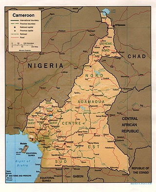
At 475,440 km2 (183,570 sq mi), Cameroon is the world's 53rd largest country. It is slightly larger than the nation of Sweden and the US state of California. It is comparable in size to Papua New Guinea. Cameroon's landmass is 472,710 km2 (182,510 sq mi), with 2,730 km2 (1,050 sq mi) of water.

<span class="mw-page-title-main">Geography of Cape Verde</span>

Cape Verde is a group of arid Atlantic islands which are home to distinct communities of plants, birds, and reptiles. The islands constitute the unique Cape Verde Islands dry forests ecoregion, according to the World Wildlife Fund.

<span class="mw-page-title-main">Geography of Equatorial Guinea</span>

The Republic of Equatorial Guinea is located in west central Africa. Bioko Island lies about 40 kilometers (24.9 mi) from Cameroon. Annobón Island lies about 595 kilometres (370 mi) southwest of Bioko Island. The larger continental region of Río Muni lies between Cameroon and Gabon on the mainland; it includes the islands of Corisco, Elobey Grande, Elobey Chico, and adjacent islets. The total land area is 28,051 km2 (10,831 sq mi). It has an Exclusive Economic Zone of 303,509 km2 (117,185 sq mi).

<span class="mw-page-title-main">Geography of Kenya</span> Geographical features of Kenya

The Geography of Kenya is diverse, varying amongst its 47 counties. Kenya has a coastline on the Indian Ocean, which contains swamps of East African mangroves. Inland are broad plains and numerous hills. Kenya borders South Sudan to the northwest, Uganda to the west, Somalia to the east, Tanzania to the south, and Ethiopia to the north. Kenya currently faces border disputes with South Sudan over the Ilemi Triangle and with Somalia over Jubbaland where, if the Somalian Government gives it up, it could be a new part of Kenya, which would bring the total land area of Kenya to approximately 692,939 sq km.

<span class="mw-page-title-main">Geography of Kiribati</span>

Kiribati consists of 32 atolls and one island in an expanse of ocean equivalent in size to the contiguous United States. The islands are scattered such that Kiribati has territory located in each of the four hemispheres. The islands of Kiribati lie roughly halfway between Hawaii and Australia in the Micronesian and Polynesian regions of the South Pacific. The three main island groupings are the Gilbert Islands, Phoenix Islands, and Line Islands. On 1 January 1995 Kiribati moved the International Date Line to include its easternmost islands and make it the same day throughout the country.

<span class="mw-page-title-main">Geography of Morocco</span> Overview of the geography of Morocco

Morocco is the northwesternmost country which spans from the Mediterranean Sea and Atlantic Ocean on the north and the west respectively, into large mountainous areas in the interior, to the Sahara desert in the far south. Morocco is a Northern African country, located in the extreme northwest of Africa on the edge of continental Europe. The Strait of Gibraltar separates Spain from Morocco with a 13 kilometres (8.1 mi) span of water. Morocco borders the North Atlantic Ocean to the west, and the western Mediterranean Sea to the north, and has borders with Algeria and disputed Western Sahara.

<span class="mw-page-title-main">Geography of Mozambique</span> Geographical features of Mozambique

The geography of Mozambique consists mostly of coastal lowlands with uplands in its center and high plateaus in the northwest. There are also mountains in the western portion. The country is located on the east coast of southern Africa, directly west of the island of Madagascar. Mozambique has a tropical climate with two seasons, a wet season from October to March and a dry season from April to September.

<span class="mw-page-title-main">Geography of the Republic of the Congo</span>

The Republic of the Congo is located in the western part of central Africa. Situated on the Equator, it is bordered by the Angolan exclave of Cabinda to the south (231 km), the Democratic Republic of the Congo to the north and east (1,229 km), the Central African Republic (487 km) and Cameroon (494 km) to the north and Gabon to the west (2,567 km). Congo has a 169 km long Atlantic coast with several important ports. The Republic of the Congo covers an area of 342,000 km², of which 341,500 km² is land while 500 km² is water. Congo claims 200 nautical miles (370 km) of territorial sea.

<span class="mw-page-title-main">Geography of São Tomé and Príncipe</span>

São Tomé and Príncipe is a small island country composed of an archipelago located in the Gulf of Guinea of the equatorial Atlantic Ocean. The nation's main islands are São Tomé Island and Príncipe Island, for which the country is named. These are located about 300 and 250 kilometres, respectively, off the northwest coast of Gabon in Central Africa.

<span class="mw-page-title-main">Geography of Sierra Leone</span>

Sierra Leone is a country in West Africa with a North Atlantic Ocean coastline to the west. It lies on the African Plate. The country's main geographical features include wooded hill country, an upland plateau, and mountains in the east. The highest peak is Mount Bintumani, which is 1,948 meters (6,391 ft) above sea level. The coastline has a belt of mangrove swamps. Freetown, the nation's capital city, has one of the world's largest natural harbours. The Rokel River is the largest river in Sierra Leone. It is 400 kilometres (250 mi) long and has a basin with a total area of 10,622 square kilometres (4,101 sq mi).

<span class="mw-page-title-main">Geography of the Solomon Islands</span>

Solomon Islands is an island country in the South Pacific Ocean, that lies east of Papua New Guinea.

<span class="mw-page-title-main">Geography of Tanzania</span>

Tanzania comprises many lakes, national parks, and Africa's highest point, Mount Kilimanjaro. Northeast Tanzania is mountainous, while the central area is part of a large plateau covered in grasslands. The country also contains the southern portion of Lake Victoria on its northern border with Uganda and Kenya.

<span class="mw-page-title-main">Geography of Togo</span>

Togo is a small Sub-Saharan state, comprising a long strip of land in West Africa. Togo's geographic coordinates are a latitude of 8° north and a longitude of 1°10′ east. It is bordered by three countries: Benin to the east, with 644 km (400 mi) of border; Burkina Faso to the north, with 126 km (78 mi) of border; and Ghana, with 877 km (545 mi) of border. To the south Togo has 56 km (35 mi) of coastline along the Bight of Benin of the Gulf of Guinea in the North Atlantic Ocean. Togo stretches 579 km (360 mi) north from the Gulf and is only 160 km (99 mi) wide at the broadest point. In total, Togo has an area of 56,785 km2 (21,925 sq mi), of which 54,385 km2 (20,998 sq mi) is land and 2,400 km2 (927 sq mi) is water.

<span class="mw-page-title-main">Geography of Western Sahara</span> Land features of Western Sahara

Western Sahara is a territory in Northern Africa, bordered by the North Atlantic Ocean, Morocco proper, Algeria, and Mauritania. Geographic coordinates: 24°30′N13°00′W

<span class="mw-page-title-main">Geography of Mali</span>

Mali is a landlocked nation in West Africa, located southwest of Algeria, extending south-west from the southern Sahara Desert through the Sahel to the Sudanian savanna zone. Mali's size is 1,240,192 square kilometers.

<span class="mw-page-title-main">Geography of Benin</span>

Benin, a narrow, key-shaped, north–south strip of land in West Africa, lies between the Equator and the Tropic of Cancer. Its latitude ranges from 6°30 N to 12°30 N and its longitude from 1° E to 3°40 E. It is bounded by Togo to the west, Burkina Faso and Niger to the north, Nigeria to the east, and the Bight of Benin to the south.

<span class="mw-page-title-main">Geography of East Timor</span> Geographical features of East Timor

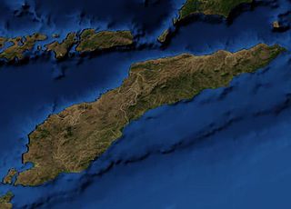
East Timor includes the mountainous eastern half of Timor, the Ocussi-Ambeno region on the northwest portion of the island of Timor, and the islands of Atauro and Jaco. The country is located northwest of Australia in the Lesser Sunda Islands at the eastern end of the Indonesian Archipelago. 'Timor' is a Portuguese derivation of 'Timor', the Malay word for "Orient"; the island of Timor is part of the Malay Archipelago and is the largest and easternmost of the Lesser Sunda Islands. East Timor is the only Asian nation to lie entirely within the Southern Hemisphere. The Loes River is the longest with a length of 80 km (50 mi). This river system covers an area of 2,184 km2 (843 sq mi). It is a small country with a land size of 14,919 km2 (5,760 sq mi). The exclusive economic zone is 70,326 km2 (27,153 sq mi).

<span class="mw-page-title-main">Madang</span> Capital of Madang Province, Papua New Guinea

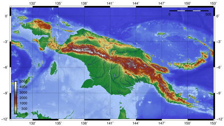
Madang is the capital of Madang Province and is a town with a population of 27,420 on the north coast of Papua New Guinea. It was first settled by the Germans in the 19th century.

<span class="mw-page-title-main">Geography of Germany</span>

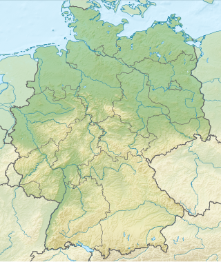
Germany is a country in Central and Western Europe that stretches from the Alps, across the North European Plain to the North Sea and the Baltic Sea. It is the second-most populous country in Europe after Russia, and is seventh-largest country by area in the continent. The area of Germany ranked 63rd and covers 357,021 km2 (137,847 sq mi), consisting of 349,223 km2 (134,836 sq mi) of land and 7,798 km2 (3,011 sq mi) of waters, smaller than Japan but larger than Republic of the Congo.

References

  1. 1 2 "Island Countries Of The World". WorldAtlas.com. Archived from the original on 2017-12-07. Retrieved 2019-08-10.
  2. "Admiralty Islands lowland rain forests". Terrestrial Ecoregions. World Wildlife Fund.
  3. Murray, N.J.; Phinn, S.R.; DeWitt, M.; Ferrari, R.; Johnston, R.; Lyons, M.B.; Clinton, N.; Thau, D.; Fuller, R.A. (2019). "The global distribution and trajectory of tidal flats". Nature. 565 (7738): 222–225. doi:10.1038/s41586-018-0805-8. PMID   30568300. S2CID   56481043.
  4. "Papua New Guinea - Climate". Encyclopedia Britannica. Retrieved 2021-10-08.
  5. https://openresearch-repository.anu.edu.au/bitstream/1885/132966/1/BG_04.pdf [ bare URL PDF ]
  6. Michael, Patrick S. (2019-12-30). "Current Evidence and Future Projections: a Comparative Analysis of the Impacts of Climate Change on Critical Climate-Sensitive Areas of Papua New Guinea". SAINS TANAH - Journal of Soil Science and Agroclimatology. 16 (2): 229–253. doi: 10.20961/stjssa.v16i2.35712 . ISSN   2356-1424. S2CID   213917240.
  7. Crate, Susan A.; Nuttall, Mark (2016-06-03). "Global averages, local extremes: the subtleties and complexities of climate change in Papua New Guinea". Anthropology and Climate Change: From Encounters to Actions. Routledge. pp. 197–208. ISBN   978-1-315-43476-6.
  8. "World Weather Information Service — Port Moresby". World Meteorological Organization. Archived from the original on 6 February 2016. Retrieved 29 January 2016.
  9. "Klimatafel von Port Moresby (Flugh.) / Papua-Neuguinea" (PDF). Baseline climate means (1961-1990) from stations all over the world (in German). Deutscher Wetterdienst. Archived (PDF) from the original on 17 August 2019. Retrieved 29 January 2016.
  10. "Station 92035 Port Moresby W.O." Global station data 1961–1990—Sunshine Duration. Deutscher Wetterdienst. Archived from the original on 2017-10-17. Retrieved 29 January 2016.
  11. Climate of Mount Hagen
  12. "World Weather Information Service — Lae City". World Meteorological Organisation. Retrieved 15 December 2015.
  13. "Climate: Wewak – Climate graph, Temperature graph, Climate table". Climate-Data.org. Retrieved 2013-12-18.
  14. "Wewak Climate and Weather Averages, Papua New Guinea". Weather2Travel. Retrieved 2013-12-18.
  15. "Daru Climate (Papua New Guinea)". climate-data.org.
  16. "Goroka climate: Average Temperature, weather by month, Goroka weather averages - Climate-Data.org". en.climate-data.org.
  17. "World Weather Information Service — Madang". World Meteorological Organisation. Retrieved 15 December 2015.
  18. "Klimatafel von Madang / Papua-Neuguinea" (PDF). Baseline climate means (1961-1990) from stations all over the world (in German). Deutscher Wetterdienst. Retrieved 29 January 2016.
  19. "Station 92014 Madang W.O". Global station data 1961–1990—Sunshine Duration. Deutscher Wetterdienst. Archived from the original on 2017-10-17. Retrieved 29 January 2016.
  20. University of Papua New Guinea The State of the Forests in Papua New Guinea Archived 2008-07-19 at the Wayback Machine

6°00′S147°00′E / 6.000°S 147.000°E / -6.000; 147.000