Route 495 is a 3.45-mile-long (5.55 km) state highway in Hudson County, New Jersey, in the United States that connects the New Jersey Turnpike at exits 16E-17 in Secaucus to New York State Route 495 (NY 495) inside the Lincoln Tunnel in Weehawken, providing access to Midtown Manhattan in New York City. The road is owned and operated by the New Jersey Turnpike Authority (NJTA) between the New Jersey Turnpike and Route 3, the New Jersey Department of Transportation (NJDOT) between Route 3 and Park Avenue near the Union City–Weehawken border, and by the Port Authority of New York and New Jersey (PANYNJ) east of Park Avenue, including the helix used to descend the New Jersey Palisades to reach the entrance of the Lincoln Tunnel. Route 495 is mostly a six-lane freeway with a reversible bus lane used during the morning rush hour. The bus lane, which runs the entire length of the freeway, continues into the Lincoln Tunnel's center tube.
The Palisades Interstate Parkway (PIP) is a 38.25-mile (61.56 km) controlled-access parkway in the U.S. states of New Jersey and New York. The parkway is a major commuter route into New York City from Rockland and Orange counties in New York and Bergen County in New Jersey. The southern terminus of the route is at the George Washington Bridge in Fort Lee, New Jersey, where it connects to Interstate 95 (I-95), US 1-9, and US 46. Its northern terminus is at a traffic circle in Fort Montgomery, New York, where the PIP meets US 9W and US 202 at the Bear Mountain Bridge. At exit 18, the PIP forms a concurrency with US 6 for the remaining duration of its run.

The Hudson–Bergen Light Rail (HBLR) is a light rail system in Hudson County, New Jersey, United States. Owned by New Jersey Transit (NJT) and operated by the 21st Century Rail Corporation, it connects the communities of Bayonne, Jersey City, Hoboken, Weehawken, Union City, at the city line with West New York, and North Bergen.

The Journal Square Transportation Center is a multi-modal transportation hub located on Magnolia Avenue and Kennedy Boulevard at Journal Square in Jersey City, New Jersey, United States. Owned and operated by the Port Authority of New York and New Jersey, the complex includes a ten-story tower, a retail plaza, a bus terminal, a two-level parking facility, and the Journal Square station of the PATH rail transit system. The underground station has a high ceiling and a mezzanine level connecting the platforms.

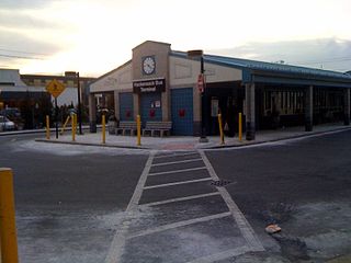
The George Washington Bridge Bus Station is a commuter bus terminal at the east end of the George Washington Bridge in the Washington Heights neighborhood of Manhattan in New York City. The bus station is owned and operated by the Port Authority of New York and New Jersey (PANYNJ). On a typical weekday, approximately 20,000 passengers on about 1,000 buses use the station.
The Northern Branch Corridor Project is a proposed extension of the Hudson-Bergen Light Rail (HBLR) from its northern terminus into eastern Bergen County, New Jersey, initially proposed in 2001. If built, the new service would use the right-of-way of the Northern Branch on which the Erie Lackawanna Railroad ran passenger service until October 3, 1966, and is currently a lightly used, stub-ended freight rail line owned by CSX Transportation. The Northern Branch Corridor is at the foot of the west side of the Hudson Palisades in the Hackensack River valley, running for much of its length parallel to Overpeck Creek. After mixed reactions and extensive community input to a draft environmental impact statement (EIS), it was decided in 2013 to terminate the line at the Englewood Hospital and Medical Center. In March 2017 the Supplementary Draft Environmental Impact Statement was approved by the Federal Transit Administration allowing for a period of public reaction. A separately-conceived and funded bridge at 69th Street in North Bergen, necessary for operation of the system, has been completed. In 2017 NJ Transit estimated that the line would open in 2029.
Paterson Plank Road is a road that runs through Passaic, Bergen and Hudson Counties in northeastern New Jersey. The route, originally laid in the colonial era, connects the city of Paterson and the Hudson River waterfront. It has largely been superseded by Route 3, but in the many towns it passes it has remained an important local thoroughfare, and in some cases been renamed.
The 181 Union City-New York is a bus route operated by New Jersey Transit in the U.S. states of New Jersey and New York. Buses head north from the Bergenline Avenue Hudson-Bergen Light Rail station in Union City along Bergenline Avenue, Woodcliff Avenue, and Palisade Avenue to Fort Lee via West New York, Guttenberg, North Bergen, Fairview, and Cliffside Park, and cross the George Washington Bridge to the George Washington Bridge Bus Station in Upper Manhattan.

Bergenline Avenue is a major commercial district in the North Hudson section of Hudson County, New Jersey, United States. The north–south streets passes through Union City, West New York, Guttenberg, and North Bergen. Its southern end is at Union City's Second Street, the north boundary of Washington Park. From there north to 47th Street, the street is one-way southbound; New York Avenue and Kennedy Boulevard serve northbound traffic. Between 48th and 49th Streets, elevators on the west side provide access to the underground Bergenline Avenue station of the Hudson-Bergen Light Rail. After passing through West New York and Guttenberg and into North Bergen, the street meets North Hudson Park, running along its west side from 79th Street to the Bergen County line through the community of Nungesser's and crosses Kennedy Boulevard. The northernmost 0.04 miles (0.064 km) of the route from Kennedy Boulevard to the Bergen County line is designated as County Route 721. North of the county line the street name becomes Anderson Avenue, which is the major commercial district for Fairview, Cliffside Park, and Fort Lee.

Weehawken Terminal was the waterfront intermodal terminal on the North River in Weehawken, New Jersey for the New York Central Railroad's West Shore Railroad division, whose route traveled along the west shore of the Hudson River. It opened in 1884 and closed in 1959. The complex contained five ferry slips, sixteen passenger train tracks, car float facilities, and extensive yards. The facility was also used by the New York, Ontario and Western Railway. The terminal was one of five passenger railroad terminals that lined the Hudson Waterfront during the 19th and 20th centuries; the others were located at Hoboken, Pavonia, Exchange Place and Communipaw, with Hoboken being the only one still in use.
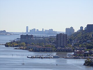
The Hudson Waterfront is an urban area of northeastern New Jersey along the lower reaches of the Hudson River, the Upper New York Bay and the Kill van Kull. Though the term can specifically mean the shoreline, it is often used to mean the contiguous urban area between the Bayonne Bridge and the George Washington Bridge that is approximately 19 miles (31 km) long. Historically, the region has been known as Bergen Neck, the lower peninsula, and Bergen Hill, lower Hudson Palisades. It has sometimes been called the Gold Coast.

Boulevard East is a two-way, mostly two lane, scenic county road in the North Hudson, New Jersey municipalities of Weehawken, West New York, Guttenberg and North Bergen. Apart from small sections at either end, the road runs along the crest of the Hudson Palisades, affording it views of the Hudson River and the New York City skyline. Developed at the turn of the 20th century, the residential road is characterized by an eclectic mix of 20th-century architecture, including private homes as well as mid and high-rise apartment buildings, mostly on its western side, with a promenade and parks along its eastern side. It is also the setting for Edward Hopper's 1934 painting East Wind Over Weehawken, which is considered one of his best works.

The Broadway Bus Terminal is a major local and regional bus terminal in Paterson, New Jersey operated by New Jersey Transit. It is located on Broadway between Memorial Drive and West Broadway in Downtown Paterson, putting it near Passaic County Community College and a few blocks from Paterson City Hall and the Great Falls Historic District, including the Great Falls.
Hackensack Bus Terminal, also called the Hackensack Bus Transfer, is a regional bus station in downtown Hackensack, New Jersey, owned and operated by New Jersey Transit. The bus station was built in the 1970s and was extensively renovated in 2007 while starting in 2006. An outdoor central island boarding–disembarking area surrounds an indoor waiting room and ticketing facilities. Service from nearby bus stops travels to locations in Bergen, Passaic, Essex and Hudson counties as well as the Port Authority Bus Terminal and George Washington Bridge Bus Station in New York City. In October 2018, the Hackensack Transit Connector, servicing the bus terminal, the city's train stations, and the County Courthouse Complex, was initiated.

Nungessers is the name of the confluence of roads that meet at the Hudson and Bergen county line at North Bergen and Fairview in northeastern New Jersey. The area is the former site of the Nungesser's Gutenberg Racetrack, a late 19th-century gaming and gambling venue. The neighborhood just south of Nungesser's is called the Racetrack Section and the municipality of Guttenberg is nearby. A White Castle, an early drive-in fast-food chain, originally built in the 1930s has long been a landmark in the neighborhood, as has adjacent North Hudson Park.

Palisade Avenue is the name given to a historic road which parallels the eastern crest of Hudson Palisades in northeastern New Jersey. It travels between Jersey City and Fort Lee, passing through Jersey City Heights, North Hudson, and Cliffside Park, with various parts carrying Hudson and Bergen county route designations. The avenue re-aligns itself at several places along its route as it crosses traditional municipal boundaries created in the 19th century. As a primary route running along the top of the Hudson Palisades, many segments offer scenic views of the Hudson River and the New York skyline. Since 2020 there is proposed state legislation to restrict building heights that would rise above the cliffs on the eastern side of Palisade Avenue along the entire corridor from Jersey City to Fort Lee.

Port Imperial is a community centered around an intermodal transit hub on the Weehawken, New Jersey, waterfront of the Hudson River across from Midtown Manhattan, served by New York Waterway ferries and buses, Hudson–Bergen Light Rail, and NJT buses. The district lies under and at the foot of Pershing Road, a thoroughfare traveling along the face of the Hudson Palisades, which rise to its west. The Hudson River Waterfront Walkway runs along the shoreline and is abutted by recently constructed residential neighborhoods, Lincoln Harbor to the south and Bulls Ferry to the north.
Spanish Transportation, officially Spanish Transportation Service Corporation, and operating under the name Express Service, is a privately operated bus company, which leases minibuses to individual operators, who provide service in and between various communities in northeastern New Jersey and to Manhattan in New York City. The fleet consists mostly of jitneys, often called "the Spanish bus" or "dollar vans" by their English-speaking users, or guaguas by their majority-Spanish clientele.

Bus rapid transit in New Jersey comprises limited-stop bus service, exclusive bus lanes (XBL) and bus bypass shoulders (BBS). Under the banner Next Generation Bus New Jersey Transit (NJT), the New Jersey Department of Transportation (NJDOT), and the metropolitan planning organizations of New Jersey (MPO) which recommend and authorize transportation projects are undertaking the creation of several additional bus rapid transit systems (BRT) in the state.
The Route 9 - Coytesville was a former streetcar line in Bergen County, New Jersey. Operated by the Palisades Railroad, a subsidiary of the North Hudson County Railway, the line ran from Coytesville in the north to Palisades Junction on the border of Fort Lee and Cliffside Park, and then split into two branches, one running to Edgewater and its ferry terminal, and one running to Weehawken Terminal. It opened sometime before 1895 and closed on June 1, 1933, although tracks remained until 1937.


