
A geyser is a spring characterized by an intermittent discharge of water ejected turbulently and accompanied by steam. As a fairly rare phenomenon, the formation of geysers is due to particular hydrogeological conditions that exist only in a few places on Earth.

A fumarole is a vent in the surface of the Earth or another rocky planet from which hot volcanic gases and vapors are emitted, without any accompanying liquids or solids. Fumaroles are characteristic of the late stages of volcanic activity, but fumarole activity can also precede a volcanic eruption and has been used for eruption prediction. Most fumaroles die down within a few days or weeks of the end of an eruption, but a few are persistent, lasting for decades or longer. An area containing fumaroles is known as a fumarole field.

A hot spring, hydrothermal spring, or geothermal spring is a spring produced by the emergence of geothermally heated groundwater onto the surface of the Earth. The groundwater is heated either by shallow bodies of magma or by circulation through faults to hot rock deep in the Earth's crust.

Volcanism, vulcanism, volcanicity, or volcanic activity is the phenomenon where solids, liquids, gases, and their mixtures erupt to the surface of a solid-surface astronomical body such as a planet or a moon. It is caused by the presence of a heat source inside the body. This internal heat partially melts solid material in the body or turns material into gas. The mobilized material rises through the body's interior and may break through the solid surface.

Geothermal energy is thermal energy extracted from the Earth's crust. It combines energy from the formation of the planet and from radioactive decay. Geothermal energy has been exploited as a source of heat and/or electric power for millennia.

The geothermal areas of Yellowstone include several geyser basins in Yellowstone National Park as well as other geothermal features such as hot springs, mud pots, and fumaroles. The number of thermal features in Yellowstone is estimated at 10,000. A study that was completed in 2011 found that a total of 1,283 geysers have erupted in Yellowstone, 465 of which are active during an average year. These are distributed among nine geyser basins, with a few geysers found in smaller thermal areas throughout the Park. The number of geysers in each geyser basin are as follows: Upper Geyser Basin (410), Midway Geyser Basin (59), Lower Geyser Basin (283), Norris Geyser Basin (193), West Thumb Geyser Basin (84), Gibbon Geyser Basin (24), Lone Star Geyser Basin (21), Shoshone Geyser Basin (107), Heart Lake Geyser Basin (69), other areas (33). Although famous large geysers like Old Faithful are part of the total, most of Yellowstone's geysers are small, erupting to only a foot or two. The hydrothermal system that supplies the geysers with hot water sits within an ancient active caldera. Many of the thermal features in Yellowstone build up sinter, geyserite, or travertine deposits around and within them.

A mudpot, or mud pool, is a type of acidic hot spring, or fumarole, with limited water. It usually takes the form of a pool of bubbling mud, as a result of the acid and microorganisms decomposing surrounding rock into clay and mud.
Hydrothermal circulation in its most general sense is the circulation of hot water. Hydrothermal circulation occurs most often in the vicinity of sources of heat within the Earth's crust. In general, this occurs near volcanic activity, but can occur in the shallow to mid crust along deeply penetrating fault irregularities or in the deep crust related to the intrusion of granite, or as the result of orogeny or metamorphism. Hydrothermal circulation often results in hydrothermal mineral deposits.

The geothermal areas in Lassen Volcanic National Park include several groups of hot springs and fumaroles, as remnants of former volcanic activity, exist in Lassen Volcanic National Park in northeastern California. Most of these lie in or are closely adjacent to Mount Tehama's caldera. Bumpass Hell is the most spectacular of these, but others of importance are Sulphur Works, Little Hot Springs Valley, Boiling Springs Lake and Devil's Kitchen. In each thermal area, the highest temperature of water generally is close to the boiling temperature at the altitude of the particular spring or fumarole — 198 °F (92 °C) at Bumpass Hell and 191 °F (88 °C) on the northwest flanks of Lassen Peak. Temperatures as high as 230 °F (110 °C) have been recorded in the park.
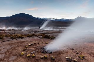
El Tatio is a geothermal field with many geysers located in the Andes Mountains of northern Chile at 4,320 metres (14,170 ft) above mean sea level. It is the third-largest geyser field in the world and the largest in the Southern Hemisphere. Various meanings have been proposed for the name "El Tatio", including "oven" or "grandfather". The geothermal field has many geysers, hot springs, and associated sinter deposits. These hot springs eventually form the Rio Salado, a major tributary of the Rio Loa, and are a major source of arsenic pollution in the river. The vents are sites of populations of extremophile microorganisms such as hyperthermophiles, and El Tatio has been studied as an analogue for the early Earth and possible past life on Mars.

Craters of the Moon Thermal Area is a region with geothermal activity north of Taupō, New Zealand. It is a part of Wairakei, the largest geothermal field in New Zealand, with a surface area of about 25 km2, which lies in the Taupō Volcanic Zone. The name springs from the many hydrothermal eruption craters, which are in part barren and which have bright colours. Combined with the numerous steam vents, constantly shifting, collapsing and reforming giving the whole area desolate appearance, and the sulphur smell, the whole area has an “unearthly” atmosphere. The craters are a relatively recent feature of the area and appeared as a result of human activity in the region.
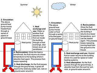
Geothermal heating is the direct use of geothermal energy for some heating applications. Humans have taken advantage of geothermal heat this way since the Paleolithic era. Approximately seventy countries made direct use of a total of 270 PJ of geothermal heating in 2004. As of 2007, 28 GW of geothermal heating capacity is installed around the world, satisfying 0.07% of global primary energy consumption. Thermal efficiency is high since no energy conversion is needed, but capacity factors tend to be low since the heat is mostly needed in the winter.
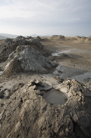
A mud volcano or mud dome is a landform created by the eruption of mud or slurries, water and gases. Several geological processes may cause the formation of mud volcanoes. Mud volcanoes are not true igneous volcanoes as they do not produce lava and are not necessarily driven by magmatic activity. Mud volcanoes may range in size from merely 1 or 2 meters high and 1 or 2 meters wide, to 700 meters high and 10 kilometers wide. Smaller mud exudations are sometimes referred to as mud-pots.

Geothermal gradient is the rate of change in temperature with respect to increasing depth in Earth's interior. As a general rule, the crust temperature rises with depth due to the heat flow from the much hotter mantle; away from tectonic plate boundaries, temperature rises in about 25–30 °C/km (72–87 °F/mi) of depth near the surface in the continental crust. However, in some cases the temperature may drop with increasing depth, especially near the surface, a phenomenon known as inverse or negative geothermal gradient. The effects of weather, the Sun, and season only reach a depth of roughly 10–20 m (33–66 ft).
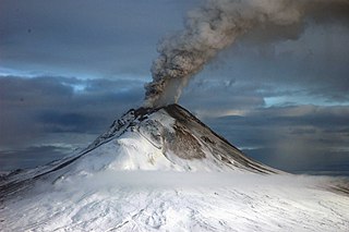
Volcanic gases are gases given off by active volcanoes. These include gases trapped in cavities (vesicles) in volcanic rocks, dissolved or dissociated gases in magma and lava, or gases emanating from lava, from volcanic craters or vents. Volcanic gases can also be emitted through groundwater heated by volcanic action.

A glacier cave is a cave formed within the ice of a glacier. Glacier caves are often called ice caves, but the latter term is properly used to describe bedrock caves that contain year-round ice.

The Geysers is the world's largest geothermal field, containing a complex of 18 geothermal power plants, drawing steam from more than 350 wells, located in the Mayacamas Mountains approximately 72 miles (116 km) north of San Francisco, California.

Geothermal power is electrical power generated from geothermal energy. Technologies in use include dry steam power stations, flash steam power stations and binary cycle power stations. Geothermal electricity generation is currently used in 26 countries, while geothermal heating is in use in 70 countries.
Hydrothermal explosions occur when superheated water trapped below the surface of the Earth rapidly converts from liquid to steam, violently disrupting the confining rock. Boiling water, steam, mud, and rock fragments are ejected over an area of a few meters up to several kilometers in diameter. Although the energy originally comes from a deep igneous source, this energy is transferred to the surface by circulating meteoric water or mixtures of meteoric and magmatic water rather than by magma, as occurs in volcanic eruptions. The energy is stored as heat in hot water and rock within a few hundred feet of the surface.

Seltún Hot Springs, Icelandic pronunciation:[ˈsɛlˌtʰuːn], is a geothermal hot spring system in Krýsuvík volcanic area, in southwest Iceland on the Mid-Atlantic Ridge of the Reykjanes peninsula.


