The London Borough of Hackney is a North-East London borough in Inner London, England. The historical and administrative heart of Hackney is Mare Street, which lies 5 miles (8 km) north-east of Charing Cross. The borough is named after Hackney, its principal district. Southern and eastern parts of the borough are popularly regarded as being part of east London, with the northwest belonging to north London. Its population is 281,120 inhabitants.

Homerton is an area in London, England, in the London Borough of Hackney. It is bordered to the west by Hackney Central, to the north by Lower Clapton, in the east by Hackney Wick, Leyton and by South Hackney to the south. In 2019, it had a population of 14,658 people. In terms of ethnicity it was 43.9% White, 33.0% Black, 10.9% Asian and 7.8% Mixed. It covered an area of 0.830 sq kilometres. Homerton ward on Hackney Borough Council is currently represented by three Labour councillors. There are fifty listed buildings located within the boundaries of the ward.

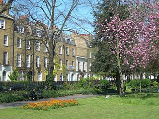
Stoke Newington is an area occupying the north-west part of the London Borough of Hackney in north-east London, England. It is five miles northeast of Charing Cross. The Manor of Stoke Newington gave its name to Stoke Newington the ancient parish.

Islington is a district in the north of Greater London, England, and part of the London Borough of Islington. It is a mainly residential district of Inner London, extending from Islington's High Street to Highbury Fields, encompassing the area around the busy High Street, Upper Street, Essex Road, and Southgate Road to the east.

New Kent Road is a 1 kilometre (0.6 mi) road in the London Borough of Southwark. The road was created in 1751 when the Turnpike Trust upgraded a local footpath. This was done as part of the general road improvements associated with the creation of Westminster Bridge; in effect it was possible to travel from the West End/ Westminster to the south-east without having to go via the Borough of Southwark but could now cross St George's Fields to the junction of Newington Causeway and Newington Butts which is where New Kent Road starts at Elephant & Castle. The route runs eastward for a few hundred yards to the junction of Great Dover Street and Tower Bridge Road, known as Bricklayers Arms, where it joins the original route to the south-east Old Kent Road.

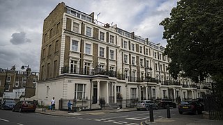
Liverpool Road is a street in Islington, North London. It covers a distance of 1+1⁄4 miles (2.0 km) between Islington High Street and Holloway Road, running roughly parallel to Upper Street through the area of Barnsbury. It contains several attractive terraces of Georgian houses and Victorian villas, many of which are listed buildings. There are a number of pubs, small businesses and restaurants along its route, as well as some secluded garden squares. The vast majority of the street is residential, with a bustling shopping and business area at the southern, Angel, end.

Newington Green is an open space in North London between Islington and Hackney. It gives its name to the surrounding area, roughly bounded by Ball's Pond Road to the south, Petherton Road to the west, Green Lanes and Matthias Road to the north, and Boleyn Road to the east. The Green is in N16 and the area is covered by the N16, N1 and N5 postcodes. Newington Green Meeting House is situated near the park.

Manor House is a district in the London Borough of Hackney. Located in North London, it lies immediately east of Finsbury Park, west of Stamford Hill and south of Harringay.
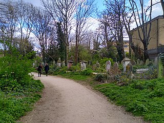
Abney Park is in Stoke Newington, London, England. It is a 13-hectare (32-acre) park dating from just before 1700, named after Lady Abney, the wife of Sir Thomas Abney, Lord Mayor of London in 1700 and one of the first directors of the Bank of England and associated with Dr Isaac Watts, who laid out an arboretum. In the early 18th century it was accessed via the frontages and gardens of two large mansions: her own manor house and Fleetwood House. Both fronted onto Church Street in what was then a quiet mainly Nonconformist (non-Anglican) village. In 1840, the grounds were turned into Abney Park Cemetery, where 200,000 people were buried. Abney Park now serves mainly as a nature reserve.
Stoke Newington was an ancient parish in the county of Middlesex. It was both a civil parish, used for administrative purposes, and an ecclesiastical parish of the Church of England.
Stoke Newington Church Street is a road in north London of the borough of Hackney. The road links Green Lanes (A105) in the west to Stoke Newington High Street, in the east. Stoke Newington is one of the villages swallowed by the growth of London in the 19th century, and Church Street retains some of this neighbourhood feel, with many restaurants, pubs, and independent (non-chain) shops.
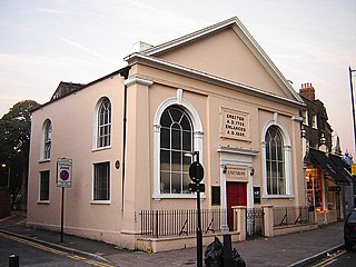
Newington Green Unitarian Church (NGUC) in north London is one of England's oldest Unitarian churches. It has had strong ties to political radicalism for over 300 years, and is London's oldest Nonconformist place of worship still in use. It was founded in 1708 by English Dissenters, a community of which had been gathering around Newington Green for at least half a century before that date. The church belongs to the umbrella organisation known as the General Assembly of Unitarian and Free Christian Churches, and has had an upturn in its fortunes since the turn of the millennium.

The Dalston Synagogue was a Jewish place of worship in the London Borough of Islington, North London, from about 1885 to 1970. Jews fleeing the pogroms of the Russian Empire, and those beginning to leave the East End of London and move northwards towards Stoke Newington and Stamford Hill established a congregation in the neighbourhood by 1876. The Victorian Gothic building was erected in Poets Road in 1885, a street just outside the boundaries of Dalston, and became one of the leading members of the United Synagogues.
In London, the Metropolitan Association for Improving the Dwellings of the Industrious Classes (MAIDIC) was a Victorian-era, philanthropically-motivated model dwellings company. The association, established in 1841, was fore-runner of the modern housing association which sought to provide affordable housing for the working classes on a privately run basis, with a financial return for investors. Although not the first society to build such homes, the Association was the first to be founded expressly for this purpose. As such it was one of the earliest adopters of the principal of the five per cent philanthropy model, outlined in the Company's resolution: "that an association be formed for the purpose of providing the labouring man with an increase of the comforts and conveniences of life, with full return to the capitalist."
The Gravel Pit Chapel was established in 1715–1716 in Hackney, then just outside London, for a Nonconformist congregation, which by the early 19th century began to identify itself as Unitarian. In 1809 the congregation moved to the New Gravel Pit Chapel nearby, while its old premises were taken over by Congregationalists. The New Gravel Pit Chapel was closed and demolished in1969.
Thomas Field Gibson FGS was a Unitarian silk manufacturer and philanthropist. He supported several novel initiatives to enhance British manufacturing quality and international trade while improving life for working people during the industrial revolution – particularly in Spitalfields where his business was centred. He also made important contributions to geology.
Arundel Square is a garden square in Barnsbury, North London. It is bounded on three sides by terraces of Victorian houses, and on the fourth with modern flats. The central public gardens contain mature trees, attractive flower beds and playground equipment.