This article is about the city in India. For its namesake district, see Giridih district. For its namesake community development block, see Giridih block.
City in Jharkhand, India
Giridih
City
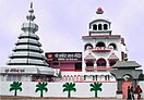
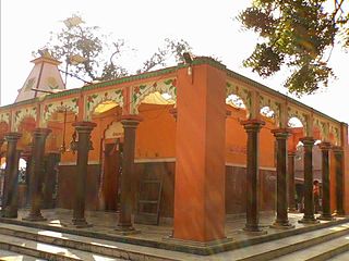
from the top: Shri Sammet Shikharji Parasnath, Kabir Gyan Mandir, Arati at Rakshitbari Puja, Chandranan and Sumitnath Temples in Madhuban, Khandoli Dam-cum-Park, Usri Falls
The literal meaning of Giridih is the land of hills and hillocks – giri, a Hindi word, means hills and dih, another word of the local Khortha dialect, means land of.
History
Giridih district was a part of Kharagdiha estate until the late 18th century. During the British Raj Giridih became a part of Jungle Terry. After Kol Uprising in 1831, the parganas of Ramgarh, Kharagdiha, Kendi and Kunda became parts of the South-West Frontier Agency before being renamed to Hazaribag, which became the administrative headquarters. The KharagdihaRajas were settled as Rajas of Raj Dhanwar in 1809, and the Kharagdiha gadis were separately settled as zamindari estates. Some of the notable Kharagdiha Zamindari Estates were Koderma, Gadi Palganj, Ledo Gadi, Gande Gadi, Ghoranji Gadi and Gadi Sirsia.[1] The town of Giridih was under the rule of the Khargdiha Zamindari Estate of Salimpur and the temporarily settled estate of Karharbari.
Cities, towns and locations in the Giridih district in North Chotanagpur Division M: municipality, CT: census town, R: rural/ urban centre, H: historical/ religious/ tourist centre Owing to space constraints in the small map, the actual locations in a larger map may vary slightly
Giridih railway station (GRD) is connected to Madhupur Junction (MDP) located 38 km to the east by a single broad gauge railway line. There is a single passenger train which runs five times a day between the two stations and takes about an hour to reach Giridih.[8]Giridih is under the administration of the Asansol division of the Eastern Railway zone of Indian Railways.
New Giridih railway station (NGRH) lies to the north of Giridih city in Gadi. It became operational after the railway line between Koderma Junction (KQR) and Maheshmunda (MMD) was completed, and is under the administration of the Dhanbad division of the Eastern Central Railway zone. Presently train is ferrying once between Koderma and Maheshmunda and once between Koderma and Madhupur via New Giridih.
Parasnath railway station (PNME), on the Howrah-Delhi grand chord line, is 48km from Giridih towards south-west in Isri and is under the administration of the Dhanbad division of the Eastern Central Railway zone.
A new rail line is proposed between New Giridih and Parasnath via Madhuban to cater to the needs of locals and Jain Tourists coming to Madhuban, Parasnath. There are other proposals as well to connect New Giridih with Dhanbad Junction via Tundi and Govindpur, and with Jhajha via Bengabad, Chakai and Sono.
Road
The NH 19 (old NH 2)/Grand Trunk Road passes through Giridih district but away from the city.
Giridih has a bus terminus in the centre of the town. The bus stand is divided into platforms for private buses. A government bus terminus is just adjacent to the main bus terminus. There are regular bus services from the city to other parts in the district. Bus service to Ranchi, Dhanbad, Bokaro, Hazaribagh, Deoghar, Jamshedpur, Durgapur, Kolkata, Howrah, Asansol, and Patna is available.
Air
Boro Aerodrome is an airstrip at the district headquarters of Giridih.[9] Giridih is well connected to some of the popular airports of Bihar, Jharkhand and West Bengal and they are:
As of 2011[update] India census,[11] Giridih Urban Agglomeration had a population of 143,529, it is the seventh largest city of Jharkhand. Males constitute 53% of the population and females 47%. Giridih has an average literacy rate of 69%, higher than the national average of 59.5%; male literacy is 74%, and female literacy is 63%. In Giridih, 15% of the population is under 6 years of age. The language spoken is known as Khortha.[12]
Hinduism is the prominent religion of Giridih city followed by 67.66% of the population. Islam is the dominant minority religion in the city followed by 30.31% of the people. Other minorities are Christians 0.84%, Sikhs 0.55%, Jains 0.47%, Buddhists 0.04%, and others 0.07%.[14]
Infrastructure
According to the District Census Handbook 2011, Giridih, Giridih covered an area of 9.75km2. Among the civic amenities, it had 41km roads with both open and closed drains, the protected water supply involved tapwater from treated sources, uncovered well, overhead tank. It had 17,381 domestic electric connections, 1,410 road light points. Among the medical facilities, it had 4 hospitals (allopathic and others), 53 dispensaries, 53 health centres, 1 family welfare centre, 5 maternity and child welfare centres, 7 maternity homes, 1 TB hospital/ clinic, 16 nursing homes, 3 chairtable hospital/ nursing homes, 2 veterinary hospitals, 25 medicine shops. Among the educational facilities it had 28 primary schools, 15 middle schools, 7 secondary schools, 8 senior secondary schools, 3 general degree colleges. It had 2 recognised shorthand, type-writing and vocational training centre,1 non-formal education centre (Sarva Siksha Abhiyan), 1 special school for disabled. Among the social, cultural and recreational facilities, it had 1 working women's hostel, 1 stadium, 4 cinema theatres, 1 auditorium/ community hall, 1 public library and reading room. Three important commodities it produced were lac, coal, mica. It had the branch offices of 14 nationalised banks, 7 private commercial banks, 2 cooperative banks, 1 agricultural credit society, 1 non-agricultural credit society.[15]
It has a growing economy. This town used to bustle with economic activity in the period from the 1960s to 1980s when the mineral mica processing and export community reaped tremendous gains through exports to the USSR. However, since the decline of the USSR and its split into twelve CIS countries, the industry has slowly declined and is currently ailing.
On the southern side of Giridih, in Beniadih, are the coal mines of Central Coalfields Limited, a subsidiary of Coal India Limited (a Maharatna and the world's largest coal miner). It is the largest industry in the Giridih district and major contributor to the economy of the town. Central Coalfields Limited itself is a Miniratna.
The Data Processing Center of Data Processing Division (DPD) of National Sample Survey Office (NSSO) provides complete IT solution from sample selection, software development to processing and tabulation of data canvassed through various socio-economic surveys of National Sample Survey Organisation.
Mica business also contribute a lot in the trade data, mainly mica is exported to China, Europe, Japan, Taiwan, US the total value of mica exports is US$ 100 million, the leading mica exporters are Jalan Mica Exports, Ratan Mica Exports, Jai Mica, Mount Hill, Chandauri Mica Syndicate Etc.
In 2006 the Indian government named Giridh one of the country's 250 most backward districts (out of a total of 640).[16] It is one of the 21 districts in Jharkhand currently receiving funds from the Backward Regions Grant Fund Programme (BRGF).
Presently, there are more than a dozen Sponge Iron and Rolling Mill Factories in Giridih. The name of few are Mongia Steel, SriBir, Siscon, Baba, Salasar, SriRam, Lal Steel, Saluja Gold, Gouri Shanker etc.
There is an Industrial Area adjacent to the city, which is full of small, medium and large Factories, these units provide employment to the locals and also to people from different parts of the country. These are namely Mongia Steel, Saluja Steel & Power, and Shivam Group of Companies.
However, pollution remains a critical issue in the surroundings of the Industrial Area which needs to be addressed by Municipal Corporation of Giridih, Chamber of Industries & Commerce and other authorities.[16]
Shri Sammed Shikharji (Hindi: श्री सम्मेद शिखरजी), also known as the Parasnath Hills, with the highest mountain peak in Jharkhand, 4480 feet above sea level, is a major Jain pilgrimage destination and one of the most sacred places for Jains in the world. According to Jain belief, twenty of the twenty-four Tirthankaras (teachers of the Jains), (including Parshanath) attained Moksha (Nirvana) from this place.
Rajdah Dham, Sabalpur, उत्तरवाहिनी गंगा (प्रकृति की अनुपम भेंट ) also known as Rajdaha, is a temple of Lord Shiva. It is situated approximately 60km Giridih and 5km from Suriya. (Near Nimatand Sabalpur). It is situated on the bank of the Barakar River.
Langta Baba Samadhi Sthal This is located in Kharagdiha, about 30km North West of the town on road towards Jamua. Langta Baba is revered both by the Hindus and the Muslims alike. People offer chadar to his samadhi as a ritual, and it is believed the wish made here by a true devotee always get fulfilled.[17]
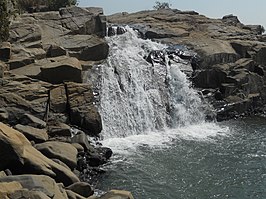
Usri Falls 13km from town, on the Tundi road, it is a picnic spot. The Usri river falls a 40 feet steep gorge in three separate streams. The place is surrounded by dense forest of Parasnath Hills.[17][18]
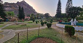
Khandoli Dam located 7km North-East of Giridih headquarters towards Bengabad block, is a scenic water reservoir and a dam. The place has been developed as a tourism attraction. It has water-related adventure sports and bird-watching. A number of other amusement facilities are available there including boating, Rock-climbing, Parasailing and Kayaking.[17][18]
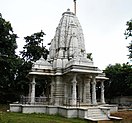
Sri Kabir Gyan Mandir in Sihodih, some 2km from Giridih headquarters, Founded in 1985, a motivational institution is headed by Sadguru Maa Gyan which spreads the message of Sant Kabir and Sanatan Dharma. It has a sacred temple Guru Govind Dham with an idol of Sant Kabir and Lord Vishnu. It also has Kabir Gyan Darshan with worth to watch murals and paintings based on life of Sant Kabir, Vedas, Morality and paintings of saints of India.[19]
Surya Mandir is located in Mirzaganj, 33km from Giridih Town. It is built in the middle of a lake in the shape of a Lotus flower. Pilgrims can visit here while returning from Langta Baba Samadhi. The temple has been declared Monument of National importance and is maintained by Archaeological Survey of India.
Notable people
Anurag Anand – Born in Giridih | Director & Producer who has produced various documentaries and tale shows for international giants like BBC, Channel 4, National Geographic & Discovery. He also owns a production house known as Inkingenious Media which is headquartered in London.
Sir Jagadish Chandra Bose spent his last days in Giridih and the Sir J.C. Bose Girl's High School is named in his honour. He died in Giridih. His then residence is now known as "Vigyan Kendra" run by "Bihar Council of Science and Technology".
Satyajit Ray, film maker and Oscar recipient, spent his childhood in Giridih. He sketched his fictional character (appearing in a series of science fiction books), scientist Professor Shonku as residing in Giridih beside the Usri river.
Krishna Ballabh Sahay was the elected member of Bihar Legislative Assembly from Giridih Constituency for several terms, including the one in which he served as the chief minister of Undivided Bihar during 1963 – 67.
Rabindranath Tagore, literary figure and Nobel Laureate, also spent some time in Giridih. He wrote his Shivaji Utsav in 1904 while residing in Giridih. The house in which he resided, Dawasika Bhawan, still exists in Giridih.
Related Research Articles
Giridih district is one of the twenty-four districts of Jharkhand state, India, and Giridih is the administrative headquarters of this district. As of 2011 it is the third most populous district of Jharkhand, after Ranchi and Dhanbad.
Parasnath is an ancient mountain peak and in the Parasnath hill Range. It is located towards the eastern end of the Chota Nagpur Plateau in the Giridih district of the Indian state of Jharkhand, India. The hill is named after Parshvanatha, the 23rd Jain Tirthankara who got salvation here. In this connection there is Jain pilgrimage Shikharji on the top of hill. The hill is also known as Marang Buru by Santhals and other autochthonous of the region in religious context.
Hesla is a village in Bagodar CD Block in Bagodar-Saria subdivision of Giridih district in the Indian state of Jharkhand.
Isri is a census town in the Dumri CD block in Dumri sub-division of Giridih district in the Indian state of Jharkhand.
Paratdih is a census town in the Giridih CD block in the Giridih Sadar subdivision of the Giridih district in the Indian state of Jharkhand.
Madhupur–Giridih–Koderma line is a 138 km (86 mi)-long single 5 ft 6 in broad gauge track from Madhupur town in Deoghar district to Koderma town in Koderma district via Giridih town in Giridih district of Jharkhand state. It is an extended route of Madhupur–Giridih railway line. The Koderma–Maheshmunda section falls under Dhanbad Division of East Central Railway and Giridih–Madhupur section under Asansol Division of Eastern Railway. The construction of 110 km (68 mi) rail line from Koderma to Maheshmunda was done under supervision of Dhanbad Division of East Central Railway.
Kharagdiha is a village in the Jamua CD block in the Khori Mahua subdivision of the Giridih district in the Indian state of Jharkhand. It had been known as Curruckdea or Curruckdeah during the British Raj.
Jharkhand Dham is a temple of the Hindu god Shiva and pilgrimage center near Dhanwar in Giridih District, Jharkhand, India.
Taratanr is a village in the Gandey CD block in Giridih Sadar subdivision of Giridih district in the Indian state of Jharkhand.
Bengabad is a village in the Bengabad CD block in the Giridih Sadar subdivision of the Giridih district in the Indian state of Jharkhand.
Pandedih is a village in the Jamua CD block in the Khori Mahuwa subdivision of the Giridih district in the Indian state of Jharkhand.
See Gawan (disambiguation) for disambiguation
Madhuban is a village in the Pirtand CD block in the Dumri subdivision of the Giridih district in the Indian state of Jharkhand.
Telodih is a census town in the Giridih CD block in the Giridih Sadar subdivision of the Giridih district in the Indian state of Jharkhand.
Sirsia is a census town in the Giridih CD block in the Giridih Sadar subdivision of the Giridih district in the Indian state of Jharkhand.
Maheshmunda is a census town in the Giridih CD block in the Giridih Sadar subdivision of the Giridih district in the Indian state of Jharkhand.
Akdoni Khurd is a census town in the Giridih CD block in the Giridih Sadar subdivision of the Giridih district in the Indian state of Jharkhand.
Barki Saraiya is a census town in the Sariya CD block in the Bagodar-Saria subdivision of the Giridih district in the Indian state of Jharkhand.
Ahilyapur is a village in the Gandey CD block in the Giridih Sadar subdivision of the Giridih district in the Indian state of Jharkhand.
Mirzaganj is a village in the Jamua CD block in the Khori Mahuwa subdivision of the Giridih district in the Indian state of Jharkhand.
1 2 "Jharkhand Fast Facts". Jharkhand. Envis Centre on Ecotourism, Govt of India. Archived from the original on 7 February 2012. Retrieved 7 March 2012.
↑ "कबीर ज्ञान". Archived from the original on 20 September 2015. Retrieved 4 October 2015.
This page is based on this Wikipedia article Text is available under the CC BY-SA 4.0 license; additional terms may apply. Images, videos and audio are available under their respective licenses.