Glen Elder, Kansas

Last updated

Glen Elder, Kansas
Glen Elder - Kansas - Statue of Liberty.jpg
Glen Elder Statue of Liberty (2017)
Mitchell County Kansas Incorporated and Unincorporated areas Glen Elder Highlighted.svg
Location within Mitchell County and Kansas
Map of Mitchell Co, Ks, USA.png
Coordinates: 39°29′59″N98°18′23″W / 39.49972°N 98.30639°W / 39.49972; -98.30639 [1]
Country United States
State Kansas
County Mitchell
Founded1871
Incorporated 1879
Area
[2]
  Total0.44 sq mi (1.13 km2)
  Land0.44 sq mi (1.13 km2)
  Water0.00 sq mi (0.00 km2)
Elevation
[1]
1,424 ft (434 m)
Population
 (2020) [3]
  Total362
  Density820/sq mi (320/km2)
Time zone UTC-6 (CST)
  Summer (DST) UTC-5 (CDT)
ZIP code
67446
Area code 785
FIPS code 20-26500
GNIS ID 2394910 [1]
Website glenelder.com

Glen Elder is a city in Mitchell County, Kansas, United States. [1] As of the 2020 census, the population of the city was 362. [3]

Contents

History

Glen Elder was originally known as West Hampton, and under the latter name was laid out and platted in 1871 by promoters who built a large gristmill at the site. [4] The town later adopted the name Glen Elder when the post office of that name was moved there from its former location a half mile north. [5] The present name is after a grove of box elder trees. [6] Glen Elder incorporated in 1879. [7]

Geography

According to the United States Census Bureau, the city has a total area of 0.44 square miles (1.14 km2), all of it land. [8]

Climate

Climate data for Glen Elder, Kansas (1991–2020 normals, extremes 1964–present)
MonthJanFebMarAprMayJunJulAugSepOctNovDecYear
Record high °F (°C)75
(24)
81
(27)
88
(31)
100
(38)
103
(39)
109
(43)
111
(44)
109
(43)
107
(42)
95
(35)
89
(32)
82
(28)
111
(44)
Mean daily maximum °F (°C)40.3
(4.6)
44.8
(7.1)
55.9
(13.3)
66.5
(19.2)
74.9
(23.8)
86.6
(30.3)
92.7
(33.7)
89.4
(31.9)
82.1
(27.8)
69.9
(21.1)
54.9
(12.7)
43.8
(6.6)
66.8
(19.3)
Daily mean °F (°C)27.0
(−2.8)
30.8
(−0.7)
41.3
(5.2)
51.5
(10.8)
61.4
(16.3)
73.4
(23.0)
78.6
(25.9)
75.8
(24.3)
67.3
(19.6)
54.9
(12.7)
40.6
(4.8)
30.6
(−0.8)
52.8
(11.6)
Mean daily minimum °F (°C)13.6
(−10.2)
16.8
(−8.4)
26.6
(−3.0)
36.5
(2.5)
47.8
(8.8)
60.2
(15.7)
64.5
(18.1)
62.3
(16.8)
52.5
(11.4)
39.9
(4.4)
26.3
(−3.2)
17.5
(−8.1)
38.7
(3.7)
Record low °F (°C)−22
(−30)
−16
(−27)
−10
(−23)
10
(−12)
24
(−4)
41
(5)
46
(8)
43
(6)
25
(−4)
14
(−10)
−9
(−23)
−27
(−33)
−27
(−33)
Average precipitation inches (mm)0.67
(17)
0.72
(18)
1.32
(34)
2.22
(56)
3.87
(98)
3.70
(94)
4.32
(110)
3.12
(79)
2.28
(58)
1.92
(49)
1.14
(29)
0.99
(25)
26.27
(667)
Average precipitation days (≥ 0.01 in)3.03.34.87.19.78.69.27.66.75.73.83.072.5
Source: NOAA [9] [10]

Demographics

Historical population
CensusPop.Note
1880 165
1890 407146.7%
1900 48118.2%
1910 56517.5%
1920 6158.8%
1930 6170.3%
1940 555−10.0%
1950 5824.9%
1960 444−23.7%
1970 422−5.0%
1980 49116.4%
1990 448−8.8%
2000 439−2.0%
2010 4451.4%
2020 362−18.7%
U.S. Decennial Census

2020 census

The 2020 United States census counted 362 people, 171 households, and 106 families in Glen Elder. [11] [12] The population density was 830.3 per square mile (320.6/km2). There were 228 housing units at an average density of 522.9 per square mile (201.9/km2). [12] [13] The racial makeup was 95.3% (345) white or European American (94.75% non-Hispanic white), 0.0% (0) black or African-American, 0.0% (0) Native American or Alaska Native, 0.28% (1) Asian, 0.0% (0) Pacific Islander or Native Hawaiian, 0.28% (1) from other races, and 4.14% (15) from two or more races. [14] Hispanic or Latino of any race was 1.93% (7) of the population. [15]

Of the 171 households, 22.2% had children under the age of 18; 53.2% were married couples living together; 19.3% had a female householder with no spouse or partner present. 33.3% of households consisted of individuals and 18.7% had someone living alone who was 65 years of age or older. [12] The average household size was 2.2 and the average family size was 2.8. [16] The percent of those with a bachelor’s degree or higher was estimated to be 18.2% of the population. [17]

22.1% of the population was under the age of 18, 4.1% from 18 to 24, 22.1% from 25 to 44, 24.3% from 45 to 64, and 27.3% who were 65 years of age or older. The median age was 47.6 years. For every 100 females, there were 94.6 males. [12] For every 100 females ages 18 and older, there were 97.2 males. [12]

The 2016-2020 5-year American Community Survey estimates show that the median household income was $51,667 (with a margin of error of +/- $15,534) and the median family income was $80,386 (+/- $11,078). [18] Males had a median income of $45,457 (+/- $7,306) versus $31,875 (+/- $15,028) for females. The median income for those above 16 years old was $36,148 (+/- $2,579). [19] Approximately, 7.3% of families and 8.3% of the population were below the poverty line, including 25.0% of those under the age of 18 and 2.2% of those ages 65 or over. [20] [21]

2010 census

As of the census [22] of 2010, there were 445 people, 193 households, and 129 families residing in the city. The population density was 1,011.4 inhabitants per square mile (390.5/km2). There were 250 housing units at an average density of 568.2 per square mile (219.4/km2). The racial makeup of the city was 96.9% White, 0.4% African American, 0.9% Native American, 0.9% Asian, and 0.9% from two or more races. Hispanic or Latino of any race were 2.0% of the population.

There were 193 households, of which 30.6% had children under the age of 18 living with them, 56.0% were married couples living together, 5.2% had a female householder with no husband present, 5.7% had a male householder with no wife present, and 33.2% were non-families. 31.6% of all households were made up of individuals, and 19.2% had someone living alone who was 65 years of age or older. The average household size was 2.31 and the average family size was 2.84.

The median age in the city was 41.2 years. 27% of residents were under the age of 18; 5.8% were between the ages of 18 and 24; 22% were from 25 to 44; 26.5% were from 45 to 64; and 18.7% were 65 years of age or older. The gender makeup of the city was 50.1% male and 49.9% female.

2000 census

As of the census [23] of 2000, there were 439 people, 196 households, and 130 families residing in the city. The population density was 1,131.1 inhabitants per square mile (436.7/km2). There were 265 housing units at an average density of 682.8 per square mile (263.6/km2). The racial makeup of the city was 96.81% White, 0.68% African American, 0.68% Native American, 0.46% Asian, 0.46% from other races, and 0.91% from two or more races. Hispanic or Latino of any race were 1.14% of the population.

There were 196 households, out of which 28.1% had children under the age of 18 living with them, 56.1% were married couples living together, 9.2% had a female householder with no husband present, and 33.2% were non-families. 27.6% of all households were made up of individuals, and 18.4% had someone living alone who was 65 years of age or older. The average household size was 2.24 and the average family size was 2.75.

In the city, the population was spread out, with 22.8% under the age of 18, 8.0% from 18 to 24, 20.5% from 25 to 44, 23.0% from 45 to 64, and 25.7% who were 65 years of age or older. The median age was 44 years. For every 100 females, there were 97.7 males. For every 100 females age 18 and over, there were 93.7 males.

The median income for a household in the city was $26,000, and the median income for a family was $32,361. Males had a median income of $21,528 versus $18,125 for females. The per capita income for the city was $20,169. About 5.4% of families and 9.9% of the population were below the poverty line, including 10.2% of those under age 18 and 10.0% of those age 65 or over.

Parks and Recreation

Education

The community is served by Waconda USD 272 public school district. The district elementary school is Lakeside Elementary School in Cawker City. The district high school is Lakeside High School in Downs with the mascot Knights. [24]

School unification combined Cawker City High School with Glen Elder High School in 1971 forming Waconda East High School. The Waconda East High School mascot was Vikings. Waconda East High School was then unified with Downs High School in 2003 forming USD 272. [25]

Glen Elder High School was closed through school unification. The Glen Elder High School mascot was Glen Elder Bearcats. [26]

The district previously operated Glen Elder Elementary School and Glen Elder Junior High School. [27]

Related Research Articles

<span class="mw-page-title-main">Gridley, Kansas</span> City in Coffey County, Kansas

Gridley is a city in Coffey County, Kansas, United States. As of the 2020 census, the population of the city was 313.

<span class="mw-page-title-main">Rantoul, Kansas</span> City in Franklin County, Kansas

Rantoul is a city in Franklin County, Kansas, United States. As of the 2020 census, the population of the city was 165.

<span class="mw-page-title-main">Gove City, Kansas</span> City in Gove County, Kansas

Gove City, more commonly known as Gove, is a city in and the county seat of Gove County, Kansas, United States. As of the 2020 census, the population of the city was 80.

<span class="mw-page-title-main">Grinnell, Kansas</span> City in Gove County, Kansas

Grinnell is a city in Gove County, Kansas, United States. As of the 2020 census, the population of the city was 260.

<span class="mw-page-title-main">Morland, Kansas</span> City in Graham County, Kansas

Morland is a city in Graham County, Kansas, United States. As of the 2020 census, the population of the city was 115.

<span class="mw-page-title-main">Formoso, Kansas</span> City in Jewell County, Kansas

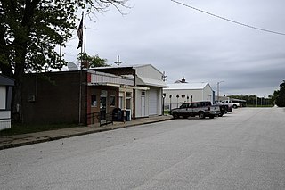
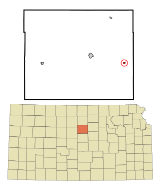
Formoso is a city in Jewell County, Kansas, United States. As of the 2020 census, the population of the city was 94.

<span class="mw-page-title-main">Beverly, Kansas</span> City in Lincoln County, Kansas

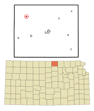
Beverly is a city in Lincoln County, Kansas, United States. As of the 2020 census, the population of the city was 135.

<span class="mw-page-title-main">Cawker City, Kansas</span> City in Mitchell County, Kansas

Cawker City is a city in Mitchell County, Kansas, United States. As of the 2020 census, the population of the city was 457. The city is located along the north shore of Waconda Lake and Glen Elder State Park. It is one of several places claiming to be home of the largest ball of twine in the world.

<span class="mw-page-title-main">Tipton, Kansas</span> City in Mitchell County, Kansas

Tipton is a city in Mitchell County, Kansas, United States. As of the 2020 census, the population of the city was 193.

<span class="mw-page-title-main">Lyndon, Kansas</span> City in Osage County, Kansas

Lyndon is a city in, and the county seat of Osage County, Kansas, United States. As of the 2020 census, the population of the city was 1,037.

<span class="mw-page-title-main">Quenemo, Kansas</span> City in Osage County, Kansas

Quenemo is a city in Osage County, Kansas, United States, along the Marais des Cygnes River. As of the 2020 census, the population of the city was 288.

<span class="mw-page-title-main">Downs, Kansas</span> City in Osborne County, Kansas

Downs is a city in Osborne County, Kansas, United States. As of the 2020 census, the population of the city was 800.

<span class="mw-page-title-main">Agra, Kansas</span> City in Phillips County, Kansas

Agra is a city in Phillips County, Kansas, United States. As of the 2020 census, the population of the city was 208.

<span class="mw-page-title-main">Munden, Kansas</span> City in Republic County, Kansas

Munden is a city in Republic County, Kansas, United States. As of the 2020 census, the population of the city was 96.

<span class="mw-page-title-main">Republic, Kansas</span> City in Republic County, Kansas, United States

Republic is a city in Republic County, Kansas, United States. As of the 2020 census, the population of the city was 82.

<span class="mw-page-title-main">Garden Plain, Kansas</span> City in Sedgwick County, Kansas

Garden Plain is a city in Sedgwick County, Kansas, United States. As of the 2020 census, the population of the city was 948.

<span class="mw-page-title-main">Lebanon, Kansas</span> City in Smith County, Kansas

Lebanon is a city in Smith County, Kansas, United States. As of the 2020 census, the population of the city was 178.

<span class="mw-page-title-main">Haddam, Kansas</span> City in Washington County, Kansas

Haddam is a city in Washington County, Kansas, United States. It is named after Haddam, Connecticut. As of the 2020 census, the population of the city was 110.

<span class="mw-page-title-main">Mahaska, Kansas</span> City in Washington County, Kansas

Mahaska is a city in Washington County, Kansas, United States. As of the 2020 census, the population of the city was 46. It is located 1 mile south of the Nebraska state line.

<span class="mw-page-title-main">Ionia, Kansas</span> Unincorporated community in Jewell County, Kansas

Ionia is an unincorporated community in Ionia Township, Jewell County, Kansas, United States. As of the 2020 census, the population of the community and nearby areas was 17.

References

  1. 1 2 3 4 U.S. Geological Survey Geographic Names Information System: Glen Elder, Kansas
  2. "2019 U.S. Gazetteer Files". United States Census Bureau. Retrieved July 24, 2020.
  3. 1 2 "Profile of Glen Elder, Kansas in 2020". United States Census Bureau. Archived from the original on March 31, 2022. Retrieved March 31, 2022.
  4. "Histories of Mitchell County Towns". Blue Skyways. Kansas State Library. 1954. Archived from the original on November 7, 2013. Retrieved June 15, 2014.
  5. Blackmar, Frank Wilson (1912). Kansas: A Cyclopedia of State History, Embracing Events, Institutions, Industries, Counties, Cities, Towns, Prominent Persons, Etc. Standard Publishing Company. pp.  752.
  6. Heim, Michael (2007). Exploring Kansas Highways. p. 78. ISBN   9780974435886.
  7. "Origin of Town Names" (PDF). Solomon Valley Highway 24 Heritage Alliance. p. 2. Retrieved April 9, 2018.
  8. "US Gazetteer files 2010". United States Census Bureau. Archived from the original on January 12, 2012. Retrieved July 6, 2012.
  9. "NOWData - NOAA Online Weather Data". National Oceanic and Atmospheric Administration. Retrieved January 15, 2022.
  10. "Station: Glen Elder Lake, KS". U.S. Climate Normals 2020: U.S. Monthly Climate Normals (1991-2020). National Oceanic and Atmospheric Administration. Retrieved January 15, 2022.
  11. "US Census Bureau, Table P16: HOUSEHOLD TYPE". data.census.gov. Retrieved January 3, 2024.
  12. 1 2 3 4 5 "US Census Bureau, Table DP1: PROFILE OF GENERAL POPULATION AND HOUSING CHARACTERISTICS". data.census.gov. Retrieved January 3, 2024.
  13. Bureau, US Census. "Gazetteer Files". Census.gov. Retrieved December 30, 2023.
  14. "US Census Bureau, Table P1: RACE". data.census.gov. Retrieved January 3, 2024.
  15. "US Census Bureau, Table P2: HISPANIC OR LATINO, AND NOT HISPANIC OR LATINO BY RACE". data.census.gov. Retrieved January 3, 2024.
  16. "US Census Bureau, Table S1101: HOUSEHOLDS AND FAMILIES". data.census.gov. Retrieved January 3, 2024.
  17. "US Census Bureau, Table S1501: EDUCATIONAL ATTAINMENT". data.census.gov. Retrieved January 3, 2024.
  18. "US Census Bureau, Table S1903: MEDIAN INCOME IN THE PAST 12 MONTHS (IN 2020 INFLATION-ADJUSTED DOLLARS)". data.census.gov. Retrieved January 3, 2024.
  19. "US Census Bureau, Table S2001: EARNINGS IN THE PAST 12 MONTHS (IN 2020 INFLATION-ADJUSTED DOLLARS)". data.census.gov. Retrieved January 3, 2024.
  20. "US Census Bureau, Table S1701: POVERTY STATUS IN THE PAST 12 MONTHS". data.census.gov. Retrieved January 3, 2024.
  21. "US Census Bureau, Table S1702: POVERTY STATUS IN THE PAST 12 MONTHS OF FAMILIES". data.census.gov. Retrieved January 3, 2024.
  22. "U.S. Census website". United States Census Bureau . Retrieved July 6, 2012.
  23. "U.S. Census website". United States Census Bureau . Retrieved January 31, 2008.
  24. "Waconda USD 272". USD 272. Retrieved January 7, 2017.
  25. "History of Glen Elder" (PDF). Solomon Valley Highway 24 Heritage Foundation. Retrieved December 30, 2016.
  26. "White Rock Champs", The Salina Journal, White Rock Champs, p.14.
  27. Home. Waconda USD 272. April 9, 2002. Retrieved on February 25, 2017.

Further reading