Glenridding

Last updated

Glenridding
Village
Glenridding, Cumbria, England - June 2009.jpg
Looking down on Glenridding village and Ullswater from the west
Location map United Kingdom Eden.svg
Red pog.svg
Glenridding
Location in the former Eden District
Cumbria UK location map.svg
Red pog.svg
Glenridding
Location within Cumbria
OS grid reference NY383170
Civil parish
Unitary authority
Ceremonial county
Region
Country England
Sovereign state United Kingdom
Post town PENRITH
Postcode district CA11
Dialling code 017684
Police Cumbria
Fire Cumbria
Ambulance North West
UK Parliament
List of places
UK
England
Cumbria
54°32′38″N2°57′11″W / 54.544°N 2.953°W / 54.544; -2.953
Greenside in 2009. The buildings seen here are the lower part of the mine complex which spreads up the hillside. Greenside2009.jpg
Greenside in 2009. The buildings seen here are the lower part of the mine complex which spreads up the hillside.
Glenridding across Ullswater, with one of the steamers leaving the pier GlenriddingFromSlopesOfPlaceFell.jpg
Glenridding across Ullswater, with one of the steamers leaving the pier

Glenridding is a village at the southern end of Ullswater, in the English Lake District. The village is popular with mountain walkers who can scale England's third-highest mountain, Helvellyn, and many other challenging peaks from there.

Contents

Etymology

The name Glenridding is generally agreed to be Cumbric in origin, with the first element being *glinn, 'valley', and the second being *redïn, 'ferns, bracken' (cf. Welsh glyn rhedyn), [1] [2] giving a meaning of 'valley overgrown with bracken'. [2] First recorded as Glenredyn in around 1290, [2] the name's present form is thought to have been influenced by the Middle English element ridding, 'clearing'. [1]

Geography

Glenridding is in the civil parish of Patterdale.

On 6 December 2015, Storm Desmond caused extensive and devastating flooding to the village, with torrential rainfall and rivers bursting their banks. Four days later, more rainfall caused rivers to burst their banks once again, leading to even more flood damage to businesses and homes in the village. Following the floods the community set up a Flood Action Group who continue to work on recovery and resilience measures to reduce the risk of future flooding. [3] [4] [5]

Community and culture

Each year, on Easter Monday, a duck race is organised by the local mountain rescue team to raise funds.[ citation needed ] The village also has a rich sporting history, particularly in the traditional Lakeland sport of Fell Running and each September the Helvellyn Triathlon is held at Jenkins' Field by the shores of Ullswater, at one time considered the toughest triathlon in the UK. [6]

Amenities

The village has accommodation including two youth hostels and camping sites. Glenridding House provides luxury bed and breakfast accommodation. There is also a tourist information centre, Ullswater Information Centre. [7]

Greenside Mine

Above the village is the site of the former Greenside Mine, once the largest lead mine in the Lake District. Lead ore was discovered in the 18th century and the site was mined from the second half of the 18th century until the mine closed in 1962. Without the mine, the houses and economy of Glenridding and the surrounding area would not have existed. [8]

Ullswater Steamers

Glenridding is home to the Ullswater 'Steamers', a leisure boat trip company which operates five vessels from the pier at Glenridding. The company was founded to provide a transport link for goods from Glenridding to Pooley Bridge and onwards to Penrith.

The village and surrounding area was used to film the TV drama series The Lakes, and has also featured in a scene in Coronation Street.

See also

Related Research Articles

<span class="mw-page-title-main">Helvellyn</span> Mountain in the English Lake District

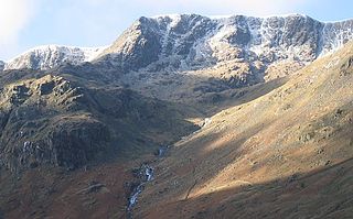
Helvellyn is a mountain in the English Lake District, the highest point of the Helvellyn range, a north–south line of mountains to the north of Ambleside, between the lakes of Thirlmere and Ullswater.

<span class="mw-page-title-main">Ullswater</span> Lake in Cumbria, England

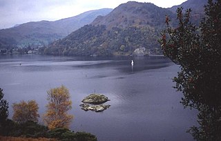
Ullswater is a glacial lake in Cumbria, England and part of the Lake District National Park. It is the second largest lake in the region by both area and volume, after Windermere. The lake is about 7 miles (11 km) long, 0.75 miles (1 km) wide, and has a maximum depth of 63 metres (207 ft). Its outflow is River Eamont, which meets the River Eden at Brougham Castle before flowing into the Solway Firth. The lake is in the administrative county of Westmorland and Furness and the ceremonial county of Cumbria.

<span class="mw-page-title-main">Catstye Cam</span> Mountain in the English Lake District, Cumbria, England

Catstye Cam is a fell in the English Lake District. It is an outlier of Helvellyn in the Eastern Fells.

<span class="mw-page-title-main">Place Fell</span> Fell in the Lake District, Cumbria, England

Place Fell is a hill in the English Lake District. It stands at the corner of the upper and middle reaches of Ullswater, with steep western flanks overlooking the villages of Glenridding and Patterdale.

<span class="mw-page-title-main">Nethermost Pike</span> Fell in Cumbria, England

Nethermost Pike is a fell in Cumbria, England, and a part of the Lake District. At 891 metres (2,923 ft) it is the second highest Wainwright in the Helvellyn range, the highest of which is Helvellyn itself. It is located close to the southern end of the ridge, with Helvellyn to the north, and High Crag and Dollywaggon Pike to the south. Nethermost Pike, along with many of the Eastern Fells, lies between Thirlmere in the west and the Ullswater catchment in the east. The closest villages are Glenridding and Patterdale on the shores of Ullswater, over 8 kilometres (5 mi) away.

<span class="mw-page-title-main">Raise (Lake District)</span> Fell in the Lake District, Cumbria, England

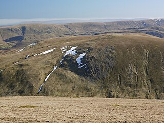
Raise is a fell in the English Lake District. It stands on the main spine of the Helvellyn range in the Eastern Fells, between Thirlmere and Ullswater.

<span class="mw-page-title-main">White Side</span> Fell in the Lake District, Cumbria, England

White Side is a fell in the English Lake District. It is situated to the east of Thirlmere and to the west of Glenridding valley. This places White Side in the Helvellyn range of the Eastern Fells, with Raise to the north and Helvellyn Lower Man to the south, both of which are of greater height.

<span class="mw-page-title-main">Patterdale</span> Village and parish in England

Patterdale is a small village and civil parish in the eastern part of the English Lake District in Cumbria, in the traditional county of Westmorland, and the long valley in which they are found, also called the Ullswater Valley. The parish had a population of 460 in 2001, increasing to 501 at the 2011 Census.

<span class="mw-page-title-main">Pooley Bridge</span> Human settlement in England

Pooley Bridge is a village in the Eden District of the northwestern English county of Cumbria, within the traditional borders of Westmorland.

<span class="mw-page-title-main">Seat Sandal</span> Fell in the Lake District, Cumbria, England

Seat Sandal is a fell in the English Lake District, situated four kilometres north of the village of Grasmere from where it is very well seen. Nevertheless, it tends to be overshadowed by its more illustrious neighbours in the Eastern Fells, Helvellyn and Fairfield.

<span class="mw-page-title-main">Hart Side</span>

Hart Side is a subsidiary top on one of the east ridges of Stybarrow Dodd, which is a mountain in the English Lake District, west of Ullswater on the main Helvellyn ridge in the Eastern Fells. With a height of 2,480 feet (760 m) Hart Side rises above the col separating it from Green Side by 75 feet (23 m).

<span class="mw-page-title-main">Birkhouse Moor</span>

Birkhouse Moor is a fell in the English Lake District, an outlier of the Helvellyn range in the Eastern Fells. It is properly an eastern ridge of Helvellyn, but was treated as a separate fell by Alfred Wainwright in his Pictorial Guide to the Lakeland Fells. That convention is followed here.

<span class="mw-page-title-main">Sheffield Pike</span>

Sheffield Pike is a fell in the English Lake District, a prominent intermediate top on one of the eastern ridges of Stybarrow Dodd. It separates and stands high above the Glencoyne and Glenridding valleys, on the eastern side of the Helvellyn range in the Eastern Fells and it looks down onto Ullswater.

<span class="mw-page-title-main">Glenridding Dodd</span>

Glenridding Dodd is a small fell in the English Lake District, at the end of a ridge descending from the Helvellyn range in the Eastern Fells. It stands above the village of Glenridding and on the western shore of Ullswater. Although small and not of great elevation, its top is a fine viewpoint for Ullswater and for the fells clustered round the valleys above Patterdale.

<span class="mw-page-title-main">Eastern Fells</span>

The Eastern Fells are a part of the Cumbrian Mountains in the Lake District of England. Centred on Helvellyn they primarily comprise a north–south ridge running between Ullswater and Lakeland's Central Valley.

<span class="mw-page-title-main">Far Eastern Fells</span> Mountain range in Cumbria, England

The Far Eastern Fells are a part of the Cumbrian Mountains in the Lake District of England. Reaching their highest point at High Street, they occupy a broad area to the east of Ullswater and Kirkstone Pass. Much quieter than the central areas of Lakeland they offer in general easier walking as the fells merge mainly into the surrounding moorlands.

MV <i>Lady Wakefield</i>

The MV Lady Wakefield is a twin screw passenger vessel, operating between Glenridding, Howtown and Pooley Bridge on Ullswater in the Lake District for Ullswater Navigation and Transit Co, marketed as Ullswater 'Steamers'.

<span class="mw-page-title-main">Ullswater 'Steamers'</span> Business operating boats on Ullswater in the English Lake District

Ullswater 'Steamers' is a boat company which provides leisure trips on Ullswater in the north-eastern part of the English Lake District. It is based in Glenridding, Cumbria. Founded in 1855, it currently operates five diesel powered vessels between four locations on the lake. The oldest boat in its fleet was launched in 1877.

<span class="mw-page-title-main">2015–16 Great Britain and Ireland floods</span> Flooding in Great Britain and Ireland during the winter of late 2015 and early 2016

The 2015–2016 Great Britain and Ireland floods were a series of heavy rainfall events which led to flooding during the winter of late 2015 and early 2016. 11 named storms produced record level rainfall from November 2015 - March 2016 in both monthly and seasonal accumulation records.

<span class="mw-page-title-main">Glenridding House</span> Recency era building in Glenridding on Ullswater

Glenridding House is a Regency era building in Glenridding on Ullswater, constructed between 1807 and 1814. It was a private summer villa until about 1860 and then became a guest house. It has recently been fully restored and is now a country house bed and breakfast and wedding venue. The building is recorded in the National Heritage List for England as a designated Grade II listed building.

References

  1. 1 2 "The Brittonic Language in the Old North" (PDF). Scottish Place Name Society. Archived from the original (PDF) on 13 August 2017. Retrieved 27 September 2018.
  2. 1 2 3 "Derivation of the names of Lake District Towns". Lakeland Memories. Retrieved 27 September 2018.
  3. Watson, Leon; Clarke-Billings, Lucy (10 December 2015). "Cumbria floods: Glenridding flooded as river bursts its banks". The Telegraph. Retrieved 12 December 2015.
  4. "Storm Desmond: Rain causes further Cumbria flooding". BBC News. 10 December 2015. Retrieved 12 December 2015.
  5. Quinn, Ben (10 December 2015). "Cumbrian village deals with more devastation as river bursts banks again". The Guardian. Retrieved 12 December 2015.
  6. "Helvellyn Triathlon | TriHard Events" . Retrieved 26 May 2020.
  7. "Lake District National Park - Ullswater Information Centre at Glenridding". Lake District National Park Authority . Retrieved 13 July 2014.
    • Murphy, Samuel (1996). Grey Gold. Tanworth-in-Arden, Warwickshire: Moiety. ISBN   0952636077.