Goldsboro, North Carolina

Last updated
Goldsboro, North Carolina
Fountain in Goldsboro.jpg
Center Street
Goldsboro, NC City Flag.gif
Goldsboro, NC City Seal.jpg
Motto(s): 
"Be More, Do More, Seymour"
NCMap-doton-Goldsboro.PNG
Location of Goldsboro in North Carolina
USA North Carolina relief location map.jpg
Red pog.svg
Goldsboro
Usa edcp relief location map.png
Red pog.svg
Goldsboro
Coordinates: 35°22′40″N77°58′19″W / 35.37778°N 77.97194°W / 35.37778; -77.97194
Country Flag of the United States.svg  United States
State Flag of North Carolina.svg  North Carolina
County Wayne
Founded / Incorporated1787 / 1847
Government
  MayorCharles Gaylor [1]
Area
[2]
   City 28.74 sq mi (74.45 km2)
  Land28.59 sq mi (74.05 km2)
  Water0.15 sq mi (0.40 km2)
Elevation
[3]
108 ft (33 m)
Population
 (2020)
   City 33,657
  Density1,177.23/sq mi (454.52/km2)
   Urban
54,456 (US: 478th) [4]
  Urban density1,024.4/sq mi (395.5/km2)
   Metro
117,333 (US: 334th)
Time zone UTC−5 (EST)
  Summer (DST) UTC−4 (EDT)
ZIP codes
27530-27534
Area code(s) 919, 984
FIPS code 37-26880 [5]
GNIS feature ID2403709 [3]
Website www.goldsboronc.gov
West Walnut Street, circa 1915 Goldsboro, North Carolina (circa 1915).jpg
West Walnut Street, circa 1915

Goldsboro, originally Goldsborough, is a city in and the county seat of Wayne County, North Carolina, United States. The population was 33,657 at the 2020 census. [6] It is the principal city of and is included in the Goldsboro, North Carolina Metropolitan Statistical Area. The nearby town of Waynesboro was founded in 1787, and Goldsboro was incorporated in 1847. It is the county seat of Wayne County. [7]

Contents

The city is situated in North Carolina's Coastal Plain and is bordered on the south by the Neuse River and the west by the Little River, approximately 40 miles (64 km) southwest of Greenville, [8] 50 miles (80 km) southeast of Raleigh, the state capital, and 75 miles (121 km) north of Wilmington in Southeastern North Carolina. Seymour Johnson Air Force Base is located in Goldsboro.

History

Around 1787, when Wayne County was formed, a town named Waynesborough grew around the county's courthouse. In 1787, William Whitfield III (son of William Whitfield II) and his son were appointed "Directors and Trustees" for designing and building the town. [9] [10] Located on the east bank of the Neuse River, the town became the county seat. Population growth in Waynesborough continued through the 1830s. However, this changed once the Wilmington and Weldon Railroad was completed in the early 1840s. By then, a hotel had been built at the intersection of the railroad and New Bern Road, which grew into a community after the train started to transport passengers from there.

More and more citizens soon relocated from Waynesborough to this growing village, named eventually "Goldsborough's Junction" after Major Matthew T. Goldsborough, an Assistant Chief Engineer with the railroad line. Later this was shortened simply to Goldsborough. In 1847, the town was incorporated and became the new Wayne County seat following a vote of the citizens of Wayne County. Local legend has it the Goldsborough supporters put moonshine in the town's well to encourage people to vote for Goldsborough.

In the following decades, Goldsborough's growth continued in part by new railroad connections to Charlotte and Beaufort. By 1861, the town's population was estimated to be 1,500. It was the trading center of a rural area that started with yeoman farmers. By this time, it had been developed as large cotton plantations dependent on the labor of enslaved African Americans, as the invention of the cotton gin had enabled profitable cultivation of short-staple cotton in the up-counties.

Because of its importance as railroad junction, Goldsborough played a significant role in the Civil War, both for stationing Confederate troops and for transporting their supplies. The town also provided hospitals for soldiers wounded in nearby battles.

In December 1862, the Battle of Goldsborough Bridge was waged, in which both sides fought for possession of the strategically significant Wilmington and Weldon Railroad Bridge. Union General John Foster arrived with his troops on December 17, aiming to destroy this bridge in order to put an end to the vital supply chain from the port of Wilmington. He succeeded on that same day, his troops overpowering the small number of defending Confederate soldiers and burning down the bridge. On their way back to New Bern, Foster's men were attacked again by Confederate troops, but they survived with fewer casualties than the enemy. The important bridge at Goldsborough was rebuilt in a matter of weeks.

Goldsborough was the scene of another Union offensive in 1865, during Union General Sherman's Carolinas Campaign. After the battles of Bentonville and Wyse Fork, Sherman's forces met with the armies of Schofield, their troops taking over the city in March. During the following three weeks, Goldsborough was occupied by over 100,000 Union soldiers. After the war was over, some of these troops continued to stay in the city.

In 1869, the spelling of the city was officially changed to Goldsboro. Wayne County was part of North Carolina's 2nd congressional district following the Civil War, when it was known as the "Black Second", for its majority-black population. This district elected four Republican African Americans to Congress in the 19th century, three of them after the Reconstruction era. The attorney George Henry White was the last to serve, being elected in 1894 and serving two terms.

The Democrat-dominated legislature established legal racial segregation in public facilities. To further this, in the 1880s it authorized a facility to serve the black mentally ill, the State Hospital in Goldsboro. In 1899 the legislature authorized an addition but did not appropriate sufficient funds. [11] This operated until after passage of civil rights legislation requiring integration of public facilities. In addition, the hospital was affected by the 1970s movement to de-institutionalize care for the mentally ill. Most states have failed to adequately support community programs to replace such facilities.

During World War II the North Carolina congressional delegation was successful in gaining the present-day Seymour Johnson Air Force Base, which opened on the outskirts of Goldsboro in April 1942 as a US Army Air Forces installation named Seymour Johnson Field. From this point on, the city's population and businesses increased as a result of the federal defense installation. The base's name was changed to Seymour Johnson AFB in 1947 following the establishment of the US Air Force as an independent service.

The city is home to Goldsboro Milling Company, the 10th largest producer of hogs in the U.S., and also a major producer of turkeys.

The Borden Manufacturing Company, First Presbyterian Church, L. D. Giddens and Son Jewelry Store, Goldsboro Union Station, Harry Fitzhugh Lee House, Odd Fellows Lodge, and Solomon and Henry Weil Houses are listed on the National Register of Historic Places. [12]

Nuclear accident

In 1961, two 3.8 megaton hydrogen bombs were dropped accidentally on the village of Faro, 12 miles (19 km) north of Goldsboro, after a B-52 aircraft broke up in mid air. The two Mark 39 nuclear bombs were released after the crew abandoned a B-52 bomber which had suffered mid-flight structural failure. Both bombs went through several steps in the arming sequence, but neither detonated. [13] One bomb was recovered. Although much of the second bomb was also recovered, a missing piece containing uranium was believed to have sunk deep into the swampy earth and could not be recovered. The piece remains in land that the Air Force eventually purchased in order to prevent any land use or digging. [14] In 2013, it was revealed that three safety mechanisms on one bomb had failed, leaving just one low-voltage switch preventing detonation. [15]

Geography

According to the United States Census Bureau, the city has a total area of 24.8 square miles (64 km2), of which 24.8 square miles (64 km2) is land and 0.04 square miles (0.10 km2) (0.08%) is water.

The Neuse River defines the southern boundary of the city. Little River is a class WS-III river that provides the water source for Goldsboro. It runs through the west of the city, and joins the Neuse River about 2 miles (3.2 km) south of US 70. [16] Stoney Creek runs through the east of the city between downtown and the Seymour Johnson Air Force Base. [17] As of 1982 the Goldsboro waste-water treatment plant accounted for 59% of total effluent discharged into the Neuse between Clayton and Kinston. [18]

The closest lakes to the city center are McArthur Lake, 3.3 miles (5.3 km) to the southwest, Cedar Lake, 4.6 miles (7.4 km) to the north and Quaker Neck Lake, 4.7 miles (7.6 km) to the west. [19] Quaker Neck Lake is an artificial lake that supplies cooling water to the H.F. Lee Energy Complex. [18] The closest reservoirs are Cogdells Pond, 2.6 miles (4.2 km) to the northeast and Wills Pond, 5.4 miles (8.7 km) to the west. Wills Pond is also known as Bear Creek W/S Lake Number Four. [20] Wills Pond impounds Old Mill Branch, a tributary of Bear Creek that flows east and enters Bear Creek near its headwaters. [21]

Climate

Goldsboro's location on the Atlantic Coastal Plain lends it a Humid subtropical climate, with hot humid summers and cool winters. The hottest month is July, with an average high temperature of 91 °F (31 °C), and an average low of 71 °F (22 °C). The coldest month is January, with an average high of 54 °F (11 °C), and an average low of 34 °F (0 °C). Annual total rainfall is 52.53 inches (1,334 mm), falling relatively evenly with a slight wet season in the late summer/early fall. Some light to moderate snowfall can take place in winter, but amounts can fluctuate greatly and can range from no snow to totals over one foot (30 cm) in some years.

Climate data for GOLDSBORO 4 SE, NC, 1991-2020 normals
MonthJanFebMarAprMayJunJulAugSepOctNovDecYear
Mean daily maximum °F (°C)54.2
(12.3)
58.1
(14.5)
65.1
(18.4)
75.2
(24.0)
81.8
(27.7)
88.0
(31.1)
91.0
(32.8)
89.1
(31.7)
83.4
(28.6)
74.8
(23.8)
65.5
(18.6)
57.3
(14.1)
73.6
(23.1)
Daily mean °F (°C)44.4
(6.9)
47.3
(8.5)
54.1
(12.3)
63.1
(17.3)
70.6
(21.4)
78.4
(25.8)
81.3
(27.4)
80.0
(26.7)
74.8
(23.8)
64.3
(17.9)
54.4
(12.4)
47.3
(8.5)
63.3
(17.4)
Mean daily minimum °F (°C)34.6
(1.4)
36.4
(2.4)
43.1
(6.2)
51.0
(10.6)
59.5
(15.3)
68.8
(20.4)
71.7
(22.1)
70.8
(21.6)
66.3
(19.1)
53.9
(12.2)
43.3
(6.3)
37.3
(2.9)
53.1
(11.7)
Average precipitation inches (mm)3.55
(90)
3.24
(82)
4.22
(107)
3.90
(99)
3.52
(89)
4.40
(112)
5.42
(138)
6.42
(163)
7.03
(179)
3.79
(96)
3.17
(81)
3.60
(91)
52.26
(1,327)
Average snowfall inches (cm)1.3
(3.3)
0.0
(0.0)
0.0
(0.0)
0.0
(0.0)
0.0
(0.0)
0.0
(0.0)
0.0
(0.0)
0.0
(0.0)
0.0
(0.0)
0.0
(0.0)
0.0
(0.0)
0.7
(1.8)
2.0
(5.1)
Average precipitation days (≥ 0.01 in)11.99.511.38.79.510.312.810.810.17.48.210.4120.9
Average snowy days (≥ 0.1 in)0.70.10.00.00.00.00.00.00.00.00.00.21.0
Source: NOAA [22] [23]

Demographics

Historical population
CensusPop.Note
1860 885
1870 1,13428.1%
1880 3,286189.8%
1890 4,01722.2%
1900 5,87746.3%
1910 6,1073.9%
1920 11,29685.0%
1930 14,98532.7%
1940 17,27415.3%
1950 21,45424.2%
1960 28,87334.6%
1970 26,960−6.6%
1980 31,87118.2%
1990 40,70927.7%
2000 39,043−4.1%
2010 36,437−6.7%
2020 33,657−7.6%
U.S. Decennial Census [24]

2020 census

Goldsboro racial composition [25]
RaceNumberPercentage
White (non-Hispanic)10,93132.48%
Black or African American (non-Hispanic)17,86753.09%
Native American 1030.31%
Asian 7812.32%
Pacific Islander 290.09%
Other/Mixed 1,5634.64%
Hispanic or Latino 2,3837.08%

As of the 2020 United States census, there were 33,657 people, 14,404 households, and 8,320 families residing in the city.

2019

As of 2019 census estimates, [26] there were 34,186 people and 14,339 households residing in the city. The population density was 1,214.9 inhabitants per square mile (469.1/km2). The racial makeup of the city was 52.7% African American, 39.9% White, 0.3% Native American, 2.2% Asian, 0.1% Pacific Islander, and 4.4% from two or more races. Hispanic or Latino of any race were 5.8% of the population.

The median income for a household in the city was $33,043, and the median income for a family was $59,844. Males had a median income of $55,223 versus $56,850 for females. The per capita income for the city was $21,666. About 26.2% of the population were below the poverty line.

Arts and culture

Sites of interest

Government

Goldsboro City Hall Goldsboro City Hall.jpg
Goldsboro City Hall

Chuck Allen served as the city's Mayor, succeeding Alfonzo "Al" King in 2016 who succeeded Hal Plonk in 2002. As mayor, Allen was the official and ceremonial head of city government and presides at all City Council meetings. The mayor and the city council are elected to office for a four-year term. Goldsboro has a council-manager government. As of 2020, the city manager is Tim Salmon. [28]

In June 2021, Allen abruptly resigned citing health issues. [29]

City council

Federal representatives

Goldsboro has been in North Carolina's 7th congressional district since January 3, 2017, and is currently represented by Republican David Rouzer. Beginning on January 3, 2021, Goldsboro will be in North Carolina's 1st congressional district and will be represented by Democrat G. K. Butterfield.

Goldsboro is represented in the Senate by Republicans Ted Budd and Thom Tillis.

Education

Colleges

High schools

Middle schools

Elementary schools

Private schools

Media

Newspaper

The Goldsboro News-Argus is a paid subscription to Goldsboro's daily newspaper with a circulation of approximately 16,500. [30]

Goldsboro Daily News is a free online daily newspaper.

Television

Goldsboro supports one television station. WHFL TV 43 is a low-power broadcast station on UHF channel 43 and is also found on two local cable networks. The station is a FamilyNet affiliate and carries religious, local, and family programming. The area is also served by television stations from the Raleigh-Durham and Greenville areas. CBS affiliate WNCN-TV, Channel 17, is licensed to Goldsboro but has its studios in Raleigh. Up until August 2010, a Public, educational, and government access (PEG) cable TV station called PACC-10 TV was available to Time Warner Cable customers. The station aired its own programming as well as City Council and County Commissioner meetings. Time Warner Cable transferred the channel to Wayne County which currently provides local announcements and community interest programming.

Radio stations based in Goldsboro

Infrastructure

Transportation

The closest civilian airport is Wayne Executive Jetport, but is only used for general aviation. The nearest public commercial airport is Pitt-Greenville Airport ( IATA : PGV) in Greenville about 36 miles northeast of Goldsboro. However, most residents use Raleigh-Durham International Airport for domestic and international travel.

Major highways that run through the city are US 70 (the main thoroughfare through Goldsboro), US 13, US 117, NC 111, and NC 581. I-795 now connects Goldsboro to I-95 in Wilson.

The Goldsboro Bypass which is a route of U.S. 70 was fully opened in May 2016. [31] Previously NC 44 while partially open and under construction, it became US 70 Bypass upon completion and has been designated as Future Interstate 42. [32] [33]

The city has a bus system known as Gateway which runs four routes.

Until the 1960s, the Southern Railway and the Seaboard Coast Line ran passenger trains in and out of Goldsboro Union Station to points west, north and south. [34] [35]

Hospitals

Notable people

Related Research Articles

<span class="mw-page-title-main">Wayne County, North Carolina</span> County in North Carolina, United States

Wayne County is a county located in the U.S. state of North Carolina. As of the 2020 census, the population was 117,333. Its county seat is Goldsboro, and it is home to Seymour Johnson Air Force Base.

<span class="mw-page-title-main">Wake County, North Carolina</span> County in North Carolina, United States

Wake County is located in the U.S. state of North Carolina. As of the 2020 census, its population was 1,129,410, making it North Carolina's most populous county. From July 2005 to July 2006, Wake County was the 9th-fastest growing county in the United States, with Cary and Raleigh being the 8th- and 15th-fastest growing communities, respectively.

<span class="mw-page-title-main">Johnston County, North Carolina</span> County in North Carolina, United States

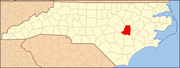
Johnston County is a county located in the U.S. state of North Carolina. As of the 2020 census, the population was 215,999. Its county seat is Smithfield.

<span class="mw-page-title-main">New Bern, North Carolina</span> City in North Carolina, United States

New Bern is a city in and the county seat of Craven County, North Carolina, United States. At the 2020 census, it had a population of 31,291.

<span class="mw-page-title-main">Creedmoor, North Carolina</span> City in North Carolina, United States

Creedmoor is a city in Granville County, North Carolina, United States. The population was 4,124 at the 2010 census.

<span class="mw-page-title-main">Snow Hill, North Carolina</span> Town in North Carolina, United States

Snow Hill is a town in Greene County, North Carolina, United States. The population was 1,595 at the 2010 census. It is the county seat of Greene County and is part of the Greenville Metropolitan Area. Snow Hill hosts numerous tennis tournaments during the year. Snow Hill is home to the Green Ridge Racquet Club. Many junior players and adults travel to Snow Hill in order to play in the USTA Sanctioned tournaments.

<span class="mw-page-title-main">Smithfield, North Carolina</span> Town in North Carolina, United States

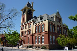
Smithfield is a town in and the county seat of Johnston County, North Carolina, United States. As of the 2010 census, its population was 10,966, and in 2019 the estimated population was 12,985. Smithfield is home to the Ava Gardner Museum and is situated along the Neuse River, where visitors enjoy the annual Smithfield Ham and Yam Festival, walks along the Buffalo Creek Greenway, and the historic downtown district. The town is located near North Carolina's Research Triangle and is about 30 miles (48 km) southeast of downtown Raleigh. The Raleigh-Durham-Cary combined statistical area has a population over 2 million residents.

<span class="mw-page-title-main">Kinston, North Carolina</span> City in North Carolina, United States

Kinston is a city in Lenoir County, North Carolina, United States, with a population of 19,900 as of the 2020 census. It has been the county seat of Lenoir County since its formation in 1791. Kinston is located in the coastal plains region of eastern North Carolina.

<span class="mw-page-title-main">Apex, North Carolina</span> Town in North Carolina, United States

Apex is a town in Wake County, North Carolina, United States. At its southern border, Apex encompasses the community of Friendship. In 1994, the downtown area was designated a historic district, and the Apex train depot, built in 1867, is designated a Wake County landmark. The depot location marks the highest point on the old Chatham Railroad, hence the town's name. The town motto is "The Peak of Good Living".

<span class="mw-page-title-main">Knightdale, North Carolina</span> Town in North Carolina, United States

Knightdale is a town in Wake County, North Carolina, United States. As of the 2020 census, Knightdale has a population of 19,435, up from 11,401 in 2010. The U.S. Census Bureau estimates the town's population to be 17,843, as of July 1, 2019. Knightdale's population grew 10.4% from 2010 to 2013, making it the second fastest-growing community in the Research Triangle region for that time period.

<span class="mw-page-title-main">Neuse River</span> River rising in the Piedmont of North Carolina

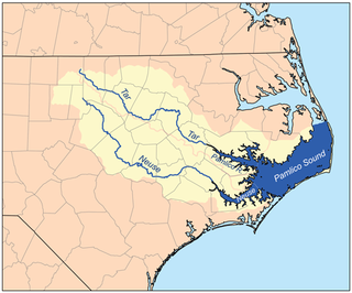
The Neuse River is a river rising in the Piedmont of North Carolina and emptying into Pamlico Sound below New Bern. Its total length is approximately 275 miles (443 km), making it the longest river entirely contained in North Carolina. The Trent River joins the Neuse at New Bern. Its drainage basin, measuring 5,630 square miles (14,600 km2) in area, also lies entirely inside North Carolina. It is formed by the confluence of the Flat and Eno rivers prior to entering the Falls Lake reservoir in northern Wake County. Its fall line shoals, known as the Falls of the Neuse, lie submerged under the waters of Falls Lake. This River also creates the beauty of the Neuse River Trail, a 34.5 miles (55.5 km) long greenway that stretches from Falls Lake Dam, Raleigh, North Carolina to Legend Park, Clayton, North Carolina.

<span class="mw-page-title-main">U.S. Route 117</span> Highway in the United States

U.S. Route 117 (US 117) is a north–south United States Highway located completely within the state of North Carolina. A spur route of US 17, the highway runs for 114 miles (183 km) from the Port of Wilmington, south of downtown Wilmington, to US 301 near Wilson. From its southern terminus, US 117 runs along Shipyard Boulevard and College Road, concurrent with North Carolina Highway 132 (NC 132) through Wilmington. US 117 intersects the eastern terminus of Interstate 40 (I-40) and parallels the interstate until reaching Faison, passing through Burgaw, Wallace, and Warsaw. The highway diverges from I-40 in Faison, running north-northeast through Mount Olive, Goldsboro, and Pikeville to its northern terminus. US 117 meets the southern end of I-795 in Goldsboro, and parallels that route before reaching its northern terminus at US 301 south of Wilson.

<span class="mw-page-title-main">Dudley, North Carolina</span> Census-designated place in North Carolina, United States

Dudley is an unincorporated community and census-designated place (CDP) in Wayne County, North Carolina, United States, about 9 miles south of Goldsboro. It was first listed as a CDP in the 2020 census with a population of 826. Dudley is included in the Goldsboro, North Carolina Metropolitan Statistical Area.

<span class="mw-page-title-main">Crabtree Creek (Neuse River tributary)</span> Stream in North Carolina, USA

Crabtree Creek is a tributary of the Neuse River in central Wake County, North Carolina, United States. The creek begins in the town of Cary and flows through Morrisville, William B. Umstead State Park, and the northern sections of Raleigh before emptying into the Neuse at Anderson Point Park, a large city park located in East Raleigh.

<span class="mw-page-title-main">North Carolina Highway 111</span> State highway in North Carolina, US

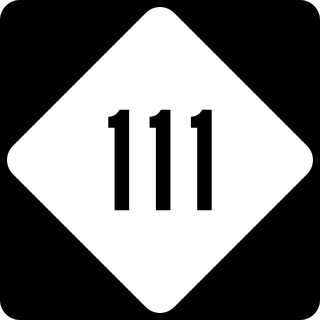
North Carolina Highway 111 (NC 111) is a 126.0-mile-long (202.8 km) primary state highway in the U.S. state of North Carolina. Traveling north–south through Eastern North Carolina, it connects the various rural towns and communities with the cities of Jacksonville, Goldsboro and Tarboro.

<span class="mw-page-title-main">U.S. Route 70 in North Carolina</span> Highway in North Carolina

U.S. Route 70 (US 70) is a part of the United States Numbered Highway System that runs from Globe, Arizona, to the Crystal Coast of the US state of North Carolina. In North Carolina, it is a major 488-mile-long (785 km) east–west highway that runs from the Tennessee border to the Atlantic Ocean. From the Tennessee state line near Paint Rock to Asheville it follows the historic Dixie Highway, running concurrently with US 25. The highway connects several major cities including Asheville, High Point, Greensboro, Durham, Raleigh, Goldsboro, and New Bern. From Beaufort on east, US 70 shares part of the Outer Banks Scenic Byway, a National Scenic Byway, before ending in the community of Atlantic, located along Core Sound.

The Little River is a tributary of the Neuse River, which originates in Moore's Pond, south of Youngsville in Franklin County. The river crosses through Wake, Johnston, and Wayne counties, joining the Neuse at Waynesborough State Park and Busco Beach just east of Goldsboro. Wake County and the City of Raleigh have been purchasing land in the watershed in order to create a reservoir in northeast Wake County.

Stoney Creek, or Stony Creek, is a watercourse in Wayne County, North Carolina, USA, that flows through the city of Goldsboro, North Carolina in its lower course before joining the Neuse River.

Bear Creek is a tributary of the Neuse River in North Carolina, USA. It drains an area of intensive agriculture, and is heavily polluted with nitrates.

New Hope is an unincorporated area and census-designated place (CDP) in Wayne County, North Carolina, United States. It was first listed as a CDP in the 2020 census with a population of 1,588.

References

  1. "Mayor of Goldsboro". City of Goldsboro. Retrieved 18 January 2024.
  2. "ArcGIS REST Services Directory". United States Census Bureau. Retrieved September 20, 2022.
  3. 1 2 U.S. Geological Survey Geographic Names Information System: Goldsboro, North Carolina
  4. United States Census Bureau (December 29, 2022). "2020 Census Qualifying Urban Areas and Final Criteria Clarifications". Federal Register.
  5. "U.S. Census website". United States Census Bureau . Retrieved 2008-01-31.
  6. "Goldsboro, North Carolina (NC) Detailed Profile - relocation, real estate, travel, jobs, hospitals, schools, crime, news, sex offenders". City-data.com. Retrieved 2013-08-16.
  7. "Find a County". National Association of Counties. Archived from the original on 2011-05-31. Retrieved 2011-06-07.
  8. https://www.google.com/maps Google Maps
  9. "Whitfield Cemetery". Wayne.lostsoulsgenealogy.com. Archived from the original on 2015-08-14. Retrieved 2017-07-17.
  10. "William Whitfield". Walkofhonor.com. Retrieved 2017-07-17.
  11. "State Hospital (Goldsboro, N.C.). Report of the State Hospital, at Goldsboro, N. C., from November 30, 1902, to November 30, 1904". Docsouth.unc.edu. Retrieved 2017-07-17.
  12. "National Register Information System". National Register of Historic Places . National Park Service. July 9, 2010.
  13. "Nuclear Mishap in Goldsboro". Broken Arrow: Goldsboro, NC (2000). Retrieved June 14, 2005.
  14. "January 1961 - Bombs Over Goldsboro". This Month in North Carolina History, University of North Carolina Libraries. Archived from the original on December 28, 2011. Retrieved April 6, 2012.
  15. "USAF Atomic Bomb in North Carolina 1961", The Guardian , September 20, 2013.
  16. US 70 Goldsboro Bypass, SR 1237 to SR 1731, Wayne County: Environmental Impact Statement, 1998, p. 3
  17. NC Ecosystem Enhancement Program (July 2004), Stoney Creek Watershed (PDF), retrieved 2018-06-22
  18. 1 2 Harned, Douglas A. (1982), "Water Quality of the Neuse River, North Carolina - Variability, pollution loads, and long-term trends", U.S. Geological Survey Water-supply Paper, U.S. Government Printing Office, p. 6, retrieved 2018-06-22
  19. "Lakes Near Goldsboro, North Carolina", GeoStat.org
  20. "Reservoirs Near Goldsboro, North Carolina", geostat.org
  21. Northeast Goldsboro Quadrangle : North Carolina-Wayne Co. (PDF), USGS: United States Geological Survey, 2013, retrieved 2018-06-22
  22. "NOWData - NOAA Online Weather Data". National Oceanic and Atmospheric Administration.{{cite web}}: Missing or empty |url= (help)
  23. "Summary of Monthly Normals 1991-2020". National Oceanic and Atmospheric Administration . Retrieved January 1, 2022.
  24. "Census of Population and Housing". Census.gov. Retrieved June 4, 2015.
  25. "Explore Census Data". data.census.gov. Retrieved 2021-12-24.
  26. "U.S. Census Bureau Quick Facts: Goldsboro city, North Carolina". U.S. Census Bureau. Retrieved December 6, 2020.
  27. Gordon, Mark W., Rediscovering Jewish Infrastructure: Update on United States Nineteenth Century Synagogues . American Jewish History, 84.1, 1996, pp. 11–27. 2019 article update.
  28. City Manager
  29. "Goldsboro mayor resigns immediately". WITN. 2021-06-15. Retrieved 2021-08-10.
  30. "Echo Media V3 Print Media Experts".
  31. "Beach-bound Triangle residents now have Goldsboro Bypass". Wral.com. 2016-05-28. Retrieved 2017-07-17.
  32. "North Carolina Gains Names for Two New Interstate Designations" (Press release). Raleigh, NC: North Carolina Department of Transportation. May 25, 2016. Archived from the original on June 16, 2016. Retrieved May 25, 2016.
  33. Special Committee on U.S. Route Numbering (May 24, 2016). "Special Committee on U.S. Route Numbering" (PDF) (Report). Washington, DC: American Association of State Highway and Transportation Officials. p. 7. Archived from the original (PDF) on December 16, 2017. Retrieved May 26, 2016.
  34. Official Guide of the Railways, June 1963, Southern Railway section
  35. Official Guide of the Railways, October 1967, Seaboard Coast Line Railroad section
  36. Giffin, Stewart S. (May 1930). "Major General John W. Gulick, Chief of Coast Artillery" (PDF). The Coast Artillery Journal. Washington, DC: U.S. Army Coast Artillery Corps. pp. 382–384. Archived (PDF) from the original on March 2, 2017. Retrieved June 18, 2018.
Government
General information