Long before the arrival of Europeans in the 17th century, all of the territory of Virginia, including the Piedmont area, was populated by various tribes of Native Americans. They were the historic tribes descended from thousands of years of succeeding and varied indigenous cultures. Among the historic tribes in the Piedmont were the Monacan, who were Siouan-speaking and were recorded as having several villages west of what the colonists later called Manakin Town on the James River.
They and other Siouan tribes traditionally competed with and were in conflict with the members of the Powhatan Confederacy, Algonquian-speaking tribes who generally inhabited the coastal Tidewater area along the Atlantic and the rivers feeding it. They also were subject to raids by Iroquois nations from the north, who were based south of the Great Lakes in present-day New York and Pennsylvania.
By the end of the 17th century, the Monacan had been decimated by warfare and infectious diseases carried by the mostly English colonists and traders; their survivors were absorbed into other Siouan tribes.
Among the earliest European settlers in this area of the Piedmont were several hundred French Huguenot religious refugees, who were given land in 1700 and 1701 by the Crown and colonial authorities about 20 miles above the falls of the James River. They settled the villages collectively known as Manakin-Sabot in this area. Soon they moved out to farms and plantations they developed. In neighboring Powhatan County, to the south across the James, they settled Manakin Town, but by 1750 had mostly moved out to farms.[5]
Goochland was founded in 1728 as the first county formed from Henrico shire, followed by Chesterfield County in 1749. Goochland originally included all of the land from Tuckahoe Creek, on both sides of the James River, west as far as the Blue Ridge Mountains.[1] In its original form, Goochland contained the modern counties of Goochland, Powhatan, Cumberland, Fluvanna, Buckingham, Nelson, and Amherst, in their entireties. In addition, the northern sections of Appomattox, Campbell, and Bedford, and the southern two-thirds of Albemarle County were also within Goochland's original boundaries. The creation of Albemarle County in 1744 and Cumberland County in 1749 removed most of Goochland's southern and western territory, reducing it to its modern size and boundaries.
The county was named for Sir William Gooch, 1st Baronet,[6] the royal lieutenant governor from 1727 to 1749. The nominal governor, the Earl of Albemarle, had remained in England. As acting royal governor, Gooch promoted settlement of the Virginia backcountry as a means to insulate the Virginia colony from Native American and New France settlements in the Ohio Country.[7]
As the colonists moved into the Piedmont west of Richmond, they first developed tobacco plantations like those of the Tidewater. After the Revolution, tobacco did not yield as high profits as markets changed. In Goochland, as in other areas of Virginia, many planters switched to growing wheat and mixed crops. This reduced their need for labor. In the early nineteenth century, some planters sold slaves in the domestic slave trade, as demand was high in the developing Deep South where cotton plantations were developed.
Goochland Courthouse
The first court was held in May 1728. The exact location of this first court is unknown, but researchers believe that the first courthouse was constructed in Goochland County between 1730 and 1737. A new courthouse was built in 1763 in Beaverdam, a short distance from the first, on the land of Alexander Baine. In the early 19th century, the courthouse was moved to its current location along Rt. 6 in central Goochland. The Goochland County Court Square was listed on the National Register of Historic Places in 1970.[8]
Revolutionary War
During the early part of 1781, Lord Cornwallis marched his sizable army through the boundaries of Goochland. They occupied and thoroughly destroyed Elkhill, a small estate of Thomas Jefferson, slaughtering the livestock for food, burning barns and fences, and finally burning down the house. They took 27 slaves as prisoners of war, and 24 died of disease in the camp.[9]
One point along the James River came to be known as Cornwallis Hill. It is said that the British general, who paused here on his way to Yorktown, where he would be defeated and surrender, remarked that this spot with its magnificent vista of the James River Valley would make an ideal site for a house.[10]
General Lafayette, a French hero of the Revolution, returned to the United States for a grand tour in 1824 and 1825. On November 2, 1824, General Lafayette "left Richmond on his way to Monticello to visit Mr. Jefferson."[4] On the way, Gen. Lafayette stopped at Powell's Tavern in Goochland. ("I spent some time at the Tavern and there was much celebration at his arrival.")[11] While there, the general met with American officers and many citizens of the county.
The county was a site of a battle late in the war. When the war broke out, James Pleasants, a native of Goochland County and descendant of the 22nd governor of the state, insisted he replace his uncle in the Goochland Light Dragoons (known during the war as Co. F, 4th Virginia Cavalry). In 1861, he was allowed to take his uncle's place. In the winter of 1864, any troops who were close to home were allowed to return to recruit more soldiers.
At the same time, the young Union Colonel Ulric Dahlgren had a plan to infiltrate central Virginia, break out nearly 12,000 Union prisoners from Belle Isle in Richmond, the Confederate capital, and destroy the city. On March 1, 1864, Dahlgren's forces reached the plantations of Sabot Hill, Dover, and Eastwood in eastern Goochland.[4]
On Pleasants's first night home, Dahlgren's raiders stole his horses but did not search the property. When Pleasants found out what happened, he grabbed his carbine and started off on foot after the raiders. Hearing a noise, he hid in the woods, and ordered a single Union cavalryman to surrender. Pleasants mounted the man's horse and forced the soldier to walk in front of him to search for more soldiers. Within a short amount of time, Pleasants had captured several Union prisoners and took them as prisoners back to Bowles' store. In all, he captured 15 Union soldiers, recovered 16 horses, and shot one officer who refused to surrender to him.[4]
Eastwood was occupied by Plumer Hobson and his wife, the daughter of Brigadier General Henry A. Wise, the last governor of Virginia before the war. On the previous night General Wise had arrived at Eastwood. When a Union detail arrived at Eastwood looking for him, his daughter said that he was in Charleston, South Carolina. Instead, he was already riding rapidly southeast to Richmond to warn the troops of the Union raiders.[4] Dahlgren went to Sabot Hill, the home of James Seddon and his wife. She answered the door and invited the officer in for some wine and Southern hospitality; she knew that Wise was on his way to Richmond and wanted to delay Dahlgren. Ultimately, due to the quick thinking by the families in Goochland, Wise was able to warn forces in Richmond, who defeated Dahlgren's raid.[4]
Convict lease program
After Reconstruction, Goochland County leased convicts as laborers to build roads in 1878. The state's practice of convict leasing was effectively a means of keeping African Americans in near-slavery conditions. The legislature passed a variety of minor nuisance laws, with penalties of fees, which they knew the cash-poor sharecroppers could not readily pay.[12] When convicted of minor offenses and unable to pay the fine, black men were jailed and leased out as convicts. They suffered frequent abuse under this system, as the state exercised little supervision of conditions.
Monument
As part of their effort at commemoration after the war, the Daughters of the Confederacy commissioned a monument to the Confederate dead, to be erected on the green of the Goochland Courthouse. It was unveiled on June 22, 1918. Among those in attendance was Robert E. Lee, a grandson of General Robert E. Lee.
Churches
In 1720, there were two parishes in Henrico County, St. James and Henrico. When Goochland County was formed, St. James Parish fell within the boundaries on both sides of the James River and westward. When Albemarle County was formed from Goochland in 1744, the Parish was divided into three. St. Anne's Parish covered Albemarle, St. James Southam Parish covered the south side of the river (now Powhatan County), and St. James Northam Parish covered the rest of Goochland.[4]
In St. James Northam Parish there were three early churches, all Anglican (and Episcopal after the church was disestablished after the Revolution): Dover Episcopal, Beaverdam Episcopal, and Lickinghole Episcopal. Dover was the first, being built in 1724; it closed sometime after the Revolutionary War. Its location and closing date are unknown. Beaverdam was located near what is now Whitehall Road, but its exact location is also unknown.
One notable church is Byrd Presbyterian Church. The congregation has some members descended from the original worshippers who were organized in 1748 at Tucker Woodson's farm by Samuel Davies, a theologian. He later served as president of Princeton University. By 1759 the group had constructed its own building on Byrd Creek. In 1838 descendants of the original congregation built a new church and began worshiping here; this church is still in use. It retains many of its original architectural features, including its slate roof and interior window valances. The cemetery has been preserved since it was established in 1838.
One of the first independent black congregations founded after the Civil War was what is now called Second Union Baptist Church, founded in 1865 near Fife/Bula northwest of Richmond. Most freedmen left white Baptist churches to form their own, and soon set up state associations with the aid of organizers from free states. Today the numerous churches in the county include several Episcopal, Baptist, Methodist, Presbyterian, and non-denominational Christian churches.
Historic homes
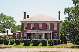
Tuckahoe Plantation – One of the older James River plantation mansions in the county, it has grounds that include a private schoolhouse where Thomas Jefferson and his Randolph cousins were educated.[13]
Clover Forest Plantation – The land was first patented in 1714. The central core of the home was not built until 1807–1811, by Captain Thomas Pemberton of the Continental Dragoons. He was later a member of the Society of the Cincinnati. It has had several owners since then.[14]
Other historic homes and mansions in Goochland can be found through the Goochland County Historical Society (see links below).
School buses
In 1973, Wayne Corporation of Richmond, Indiana introduced a safer design in school bus construction, the Lifeguard. Shortly afterward, the manufacturer held a nationwide contest to gain ideas to improve school bus safety, with the grand prize to be the award of a new Lifeguard school bus. Pearl P. Randolph, the first black member of the Goochland County School Board, created the winning entry.
As a result, the Goochland County Public Schools received the new school bus. Her idea was to install sound baffles in the ceilings of school bus bodies to help reduce driver distraction. Compact forms of such equipment were later developed in the 1980s by Wayne and other bus manufacturers when diesel engines (and their greater noise) became commonplace.
The Goochland County Public Schools system provides public school from K-12 for the county at five schools for 2,500 students. In 2020 the all-boys Benedictine College Preparatory and all-girls Saint Gertrude High School moved from their separate campuses in downtown Richmond to a combined campus in Goochland under the Benedictine Schools of Richmond.[15]
United States presidential election results for Goochland County, Virginia[16]
Contributors to Goochland's increased growth in the early 2000s was the construction of the West Creek Business Park, as well as the completion of Richmond's semi-circumferentialState Route 288. The latter connected the county to the major travel corridors of I-64 and I-95. The industrial park began attracting many businesses, including the corporate headquarters for Farm Bureau of Virginia and Performance Food Group (PFG), as well as Hallmark Youth Care, and CarMax.
Top employers
According to the county's 2011 Comprehensive Annual Financial Report,[17] the top employers in the county are:
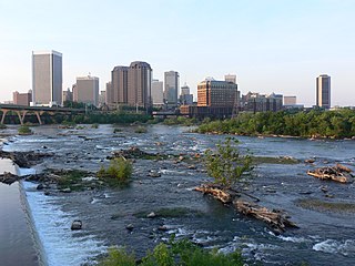
According to the U.S. Census Bureau, the county has a total area of 290 square miles (750km2), of which 281 square miles (730km2) is land and 8 square miles (21km2) (2.9%) is water.[18] Goochland County is drained by the James River.
Goochland County, Virginia – Racial and ethnic composition Note: the US Census treats Hispanic/Latino as an ethnic category. This table excludes Latinos from the racial categories and assigns them to a separate category. Hispanics/Latinos may be of any race.
As of the census[27] of 2000, there were 16,863 people, 6,158 households, and 4,710 families residing in the county. The population density was 59 peopleper square mile (23 people/km2). There were 6,555 housing units at an average density of 23 unitsper square mile (8.9 units/km2). The racial makeup of the county was 72.71% White, 25.64% Black or African American, 0.20% Native American, 0.47% Asian, 0.01% Pacific Islander, 0.20% from other races, and 0.77% from two or more races. 0.85% of the population were Hispanic or Latino of any race.
There were 6,158 households, out of which 29.90% had children under the age of 18 living with them, 64.60% were married couples living together, 8.40% had a female householder with no husband present, and 23.50% were non-families. 19.90% of all households were made up of individuals, and 7.40% had someone living alone who was 65 years of age or older. The average household size was 2.51 and the average family size was 2.88.
In the county, the population was spread out, with 21.30% under the age of 18, 5.30% from 18 to 24, 32.10% from 25 to 44, 28.90% from 45 to 64, and 12.50% who were 65 years of age or older. The median age was 40 years. For every 100 females, there were 101.50 males. For every 100 females age 18 and over, there were 98.30 males.
The median income for a household in the county was $56,307, and the median income for a family was $64,685. Males had a median income of $41,663 versus $29,519 for females. The per capita income for the county was $29,105. 6.90% of the population and 4.30% of families were below the poverty line. Out of the total people living in poverty, 7.70% are under the age of 18 and 8.10% are 65 or older.
Powhatan County is a county located in the Commonwealth of Virginia. As of the 2020 census, the population was 30,033. Its county seat is Powhatan.
Henrico County, officially the County of Henrico, is located in the Commonwealth of Virginia in the United States. As of the 2020 census, the population was 334,389 making it the fifth-most populous county in Virginia. Henrico County is included in the Greater Richmond Region. There is no incorporated community within Henrico County; therefore, there is no incorporated county seat either. Laurel, an unincorporated CDP, serves this function.
Fluvanna County is a county located in the Piedmont region of the Commonwealth of Virginia, United States. As of the 2020 census, the population was 27,249. Its county seat is Palmyra, while the most populous community is the census designated place of Lake Monticello.
Charles City County is a county located in the U.S. commonwealth of Virginia. The county is situated southeast of Richmond and west of Jamestown. It is bounded on the south by the James River and on the east by the Chickahominy River.
Albemarle County is a county located in the Piedmont region of the Commonwealth of Virginia. Its county seat is Charlottesville, which is an independent city and enclave entirely surrounded by the county. Albemarle County is part of the Charlottesville Metropolitan Statistical Area. As of the 2020 census, the population was 112,395.
Short Pump is a census-designated place (CDP) in Henrico County, Virginia, United States. It is a suburb of Richmond, Virginia. The population was 30,626 at the 2020 census.
Tuckahoe is a census-designated place (CDP) in Henrico County, Virginia, United States. It is an upper middle-class suburb to the west of Richmond. The population of Tuckahoe was 44,990 at the 2010 census. It is named after the area's history as the site of Thomas Randolph's Tuckahoe Plantation which still stands along the James River.
The Greater Richmond Region, the Richmond metropolitan area or Central Virginia, is a region and metropolitan area in the U.S. state of Virginia, centered on Richmond. The U.S. Office of Management and Budget (OMB) defines the area as the Richmond, VA Metropolitan Statistical Area, a Metropolitan Statistical Area (MSA) used by the U.S. Census Bureau and other entities. The OMB defines the area as comprising 17 county-level jurisdictions, including the independent cities of Richmond, Petersburg, Hopewell, and Colonial Heights. As of 2020, it had a population of 1,314,434, making it the 44th largest MSA in the country.
The West End is a part of Richmond, Virginia. Definitions of the bounds of the West End vary, it may include only the western part of the city of Richmond or extend as far as western Henrico County. As there is no one municipal organization that represents this specific region, the boundaries are loosely defined as being north of the James River, west of I-195, and south of Broad Street. Historically, the Richmond neighborhoods of the Fan and the Museum District were a part of the West End. A primary conduit through the West End is Interstate 64.
The Monacan Indian Nation is one of eleven Native American tribes recognized since the late 20th century by the U.S. Commonwealth of Virginia. In January 2018, the United States Congress passed an act to provide federal recognition as tribes to the Monacan and five other tribes in Virginia. They had earlier been so disrupted by land loss, warfare, intermarriage, and discrimination that the main society believed they no longer were "Indians". However, the Monacans reorganized and asserted their culture.
State Route 6 is a primary state highway in the U.S. state of Virginia. Known for most of its length as River Road, the state highway runs 102.26 miles (164.57 km) from U.S. Route 250 in Afton east to SR 161 in Richmond. SR 6 is one of the main highways of mountainous Nelson County, where the highway runs north–south from its beginning to US 29. From Scottsville to Richmond, the state highway parallels the James River. SR 6 is a major suburban highway through southwestern Henrico County and the main street of Richmond's West End.
Varina Farms, also known as Varina Plantation or Varina Farms Plantation or Varina on the James, is a plantation established in the 17th century on the James River about 10 miles (16 km) south of Richmond, Virginia. An 820-acre (330 ha) property was listed on the National Register of Historic Places in 1977 as "Varina Plantation". At that time it included two contributing buildings and one other contributing site.
The Southside of Richmond is an area of the Metropolitan Statistical Area surrounding Richmond, Virginia. It generally includes all portions of the City of Richmond that lie south of the James River, and includes all of the former city of Manchester. Depending on context, the term "Southside of Richmond" can include some northern areas of adjacent Chesterfield County, Virginia in the Richmond-Petersburg region. With minor exceptions near Bon Air, VA, the Chippenham Parkway forms the border between Chesterfield County and the City of Richmond portions of Southside, with some news agencies using the term "South Richmond" to refer to the locations in Southside located in the city proper.
State Route 288 is a primary state highway in the U.S. state of Virginia. It is a freeway-standard partial beltway around the southwest side of the Richmond, Virginia metropolitan area in portions of Goochland, Powhatan, and Chesterfield counties. SR 288 was officially dedicated as the World War II Veterans Memorial Highway in 2004.
Manakin Sabot, consisting of the villages of Manakin and Sabot, is an unincorporated community in Goochland County, Virginia, United States. It is located northwest of Richmond in the Piedmont and is part of the Greater Richmond region.
Tuckahoe, also known as Tuckahoe Plantation, or Historic Tuckahoe is located in Tuckahoe, Virginia on Route 650 near Manakin Sabot, Virginia, overlapping both Goochland and Henrico counties, six miles from the town of the same name. Built in the first half of the 18th century, it is a well-preserved example of a colonial plantation house and is particularly distinctive as a colonial prodigy house. Thomas Jefferson is also recorded as having spent some of his childhood here. It was declared a National Historic Landmark in 1969.
Thomas Randolph, also known as Thomas Randolph of Tuckahoe, was the first European settler at Tuckahoe, a member of the House of Burgesses, and the second child of William Randolph and Mary Isham, daughter of Henry Isham and Katherine Isham (Banks).
The following is a timeline of the history of the city of Richmond, Virginia, United States
William Randolph was American politician and county clerk. He was the son of Thomas Randolph of Tuckahoe in Goochland County, Virginia. He built the elegant two-story residence for Tuckahoe. Randolph held the positions of Clerk and Justice in Goochland County and he represented the county as a member of the House of Burgesses. He was the first Clerk of Albemarle County.
↑ "Backcountry Frontier of Colonial Virginia", Encyclopedia Virginiahttp://www.encyclopediavirginia.org/Backcountry_Frontier_of_Colonial_Virginia#start_entry Quote: "The major push toward the British occupation of the backcountry began with a series of land orders totaling close to 400,000 acres (160,000ha) west of the Blue Ridge, issued by Lieutenant Governor William Gooch between 1730 and 1732" ..."Settlement of the valley by British subjects would secure and defend Virginia, not only in conflicts with northern and southern Indians, but also in the imperial struggles that had convulsed the Atlantic world for the previous three decades, during which New France had extended settlements and garrisons from Canada to Louisiana along the broad Ohio and Mississippi river systems."
This page is based on this Wikipedia article Text is available under the CC BY-SA 4.0 license; additional terms may apply. Images, videos and audio are available under their respective licenses.