Saxony-Anhalt is a state of Germany, bordering the states of Brandenburg, Saxony, Thuringia and Lower Saxony. It covers an area of 20,451.7 square kilometres (7,896.4 sq mi) and has a population of 2.18 million inhabitants, making it the 8th-largest state in Germany by area and the 11th-largest by population. Its capital is Magdeburg and its largest city is Halle (Saale).

The Goseck Circle is a Neolithic structure in Goseck in the Burgenlandkreis district in Saxony-Anhalt, Germany.

Weißenfels is the largest town of the Burgenlandkreis district, in southern Saxony-Anhalt, central Germany. It is situated on the river Saale, approximately 30 km (20 mi) south of Halle.

Nienburg is a town in the district of Salzlandkreis in Saxony-Anhalt, Germany. It is located in the lower Saale valley, approx. 5 km northeast of Bernburg. In January 2010 it absorbed the former municipalities Gerbitz, Latdorf, Neugattersleben, Pobzig and Wedlitz, that became Ortschaften or municipal divisions of the town. In 2020 its population was 6,104.

Landsberg is a town in the Saalekreis in the state of Saxony-Anhalt, Germany
Könnern (help·info) is a town in the district of Salzlandkreis, in Saxony-Anhalt, Germany. It is situated on the right bank of the river Saale, approx. 15 km south of Bernburg, and 25 km northwest of Halle (Saale).

Genthin is a town in Jerichower Land district, in Saxony-Anhalt, Germany.

Eckartsberga is a town in the Burgenlandkreis district of Saxony-Anhalt, Germany. It is situated west of Naumburg. It is part of the Verbandsgemeinde An der Finne. Since 2009 it has included the former municipalities of Burgholzhausen and Tromsdorf.

Laucha an der Unstrut is a town in the Burgenlandkreis district, in Saxony-Anhalt, Germany. It is situated on the river Unstrut, northwest of Naumburg. It is part of the Verbandsgemeinde Unstruttal. On 1 July 2009 it absorbed the former municipalities Burgscheidungen and Kirchscheidungen.

Osterfeld is a town in the Burgenlandkreis district, in Saxony-Anhalt, Germany. It is situated southeast of Naumburg. It is part of the Verbandsgemeinde Wethautal. On 1 January 2010 it absorbed the former municipalities Goldschau, Heidegrund and Waldau.

Stößen is a town in the Burgenlandkreis district, in Saxony-Anhalt, Germany. It is situated southeast of Naumburg. It is part of the Verbandsgemeinde Wethautal.

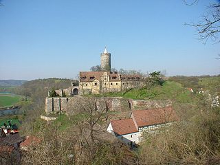
Bad Dürrenberg is a spa town in the Saalekreis district, in Saxony-Anhalt, Germany. It is situated on the river Saale, approx. 8 km southeast of Merseburg. It is known for its graduation tower, the largest one in Germany.

Kabelsketal is a municipality in the Saalekreis district, in Saxony-Anhalt, Germany. It is situated east of Halle (Saale). It was formed in 2004 out of the villages of Dieskau, Dölbau, Gröbers und Großkugel.

Barby is a town in the Salzlandkreis district, in Saxony-Anhalt, Germany. It is situated on the left bank of the River Elbe, near the confluence with the Saale, approx. 25 km (16 mi) southeast of Magdeburg. Since an administrative reform of 1 January 2010 it comprises the former municipalities of the Verwaltungsgemeinschaft Elbe-Saale, except for Gnadau, that joined Barby in September 2010. The Barby Ferry, a reaction ferry across the Elbe, links Barby with Zerbst-Walternienburg.

Teuchern is a town in the Burgenlandkreis district, in Saxony-Anhalt, Germany. It is situated approximately 10 km southeast of Weißenfels. On 1 January 2011 it absorbed the former municipalities Deuben, Gröben, Gröbitz, Krauschwitz, Nessa, Prittitz and Trebnitz. These 7 former municipalities and Teuchern proper are now Ortschaften or municipal divisions of the town Teuchern.
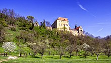
Schönburg is a municipality in the Burgenlandkreis district, in Saxony-Anhalt, Germany. It is situated 5 km east of Naumburg, on the river Saale. It is part of the Verbandsgemeinde Wethautal.
Burgenlandkreis is a district in Saxony-Anhalt, Germany. Its area is 1,414.0 km2 (545.9 sq mi).

Bitterfeld-Wolfen is a town in the district Anhalt-Bitterfeld, Saxony-Anhalt, Germany. It is situated in south-eastern Saxony-Anhalt, west of the river Mulde, in an area that is dominated by heavy industry and lignite mining. The town was formed by merger of the towns Bitterfeld and Wolfen and the municipalities Greppin, Holzweißig and Thalheim on 1 July 2007.

Diesdorf is a municipality (Flecken) in the district Altmarkkreis Salzwedel, in Saxony-Anhalt, Germany.

Balgstädt is a municipality in the Burgenlandkreis district, in Saxony-Anhalt, Germany. Since 2009 it has incorporated the former municipalities of Burkersroda, Größnitz and Hirschroda.