Notes
| This article about a building or structure in Azerbaijan is a stub. You can help Wikipedia by expanding it. |
Govurqala is a name shared by four archaeological sites in Azerbaijan, located in Nakhchivan.
Govurqala here is 35 km north-west from Nakhchivan, on the left bank of Araz. Inhabited place is dated back to the Bronze Age (3rd–2nd century BC), the area is over 5 ha. [1] During the 1936 and 1967–75 excavations different stone tools, monochrome and polychrome ceramics, stone tombs etc. were revealed. [1] In the middle of the 2nd century BC, the place turned into the town-like settlement and the centre of tribal alliances. [1] Population was engaged in agriculture, stock-breeding and pottery-making. [1]
| This article about a building or structure in Azerbaijan is a stub. You can help Wikipedia by expanding it. |

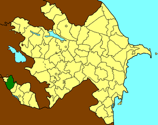
The Nakhchivan Autonomous Republic is a landlocked exclave of the Republic of Azerbaijan. The region covers 5,500 km2 (2,100 sq mi) with a population of 414,900, bordering Armenia to the east and north, Iran to the south and west, and Turkey to the northwest.
Şərur is a rayon of Azerbaijan in the Nakhchivan Autonomous Republic. The district was established on August 8, 1930. In the north and north-east it is bordered by the Armenia, and in the south and south-west by the Iran. The area of district is 872.26 square kilometres (336.78 sq mi). There is 1 city and 65 villages within the district. The administrative center of the district is the Sharur town. It has a population of 96,000.

Armenians in Azerbaijan are the Armenians who lived in great numbers in the modern state of Azerbaijan and its precursor, Soviet Azerbaijan. According to the statistics, about 500,000 Armenians lived in Soviet Azerbaijan prior to the outbreak of Nagorno Karabakh War in 1988. Most of the Armenian-Azerbaijanis however had to flee the republic, like Azerbaijanis in Armenia, in the events leading up to the Nagorno-Karabakh War, a result of the ongoing Armenian-Azerbaijani conflict. Atrocities directed against the Armenian population have reportedly taken place in Sumgait, Ganja and Baku. Today the vast majority of Armenians in Azerbaijan live in territory controlled by the break-away region Nagorno-Karabakh which declared its unilateral act of independence in 1991 under the name Nagorno-Karabakh Republic but has not been recognised by any country, including Armenia.

Vənənd is a village and municipality in the Ordubad Rayon of Nakhchivan, Azerbaijan. It is located in the near of the Ordubad-Unus highway, 17 km in the north-west from the district center, on the bank of the Vanandchay river. People of the village is busy with gardening, grain growing, cotton-growing, animal husbandry. There are secondary school, music school, library, culture house, a medical center and kindergarten in the village. It has a population of 2,347. The municipality consists of the villages of Vənənd and Xanağa.
Xoşkeşin is a village and municipality in the Julfa Rayon of Nakhchivan, Azerbaijan. It is located 34 km in the north from the district center, on the left bank of the Alinjachay River, on the slope of the Zangezur ridge. Its population is busy with vine-growing, farming and animal husbandry. There are secondary school, club, two libraries, communication branch, and a medical center in the village. It has a population of 383. The Ilandağ cuneiform inscriptions have been recorded in the vicinity of the village.
Qazançı, also known as Shahkert, is a village and municipality in the Julfa Rayon of Nakhchivan, Azerbaijan. It is located 43 km in the north from the district center, on the right bank of the Alinjachay River, on the slope of the Zangezur ridge.
Nahajir is a village and municipality in the Babek District of Nakhchivan, Azerbaijan. It is located 22 km in the north from the district center, on the foothill area. Its population is busy with farming and animal husbandry. There are secondary school, club, two library and a medical center in the village. It has a population of 514. Until 6 January 2015, it belonged to the neighbouring Julfa District.
Ərəfsə is a village and municipality in the Julfa Rayon of Nakhchivan, Azerbaijan. It is located 55 km in the north from the district center, on the right bank of the Alinjachay River, on the slope of the Zangezur ridge. Its population is busy with vine-growing, grain-growing and animal husbandry. There are secondary school, cultural house, two libraries, communication branch, and a medical center in the village. It has a population of 940. There exist the Daş Körpü and the Xarabalıq settlement of the Middle Ages in the north-east from the Arafsa village.
Külüs is a village and municipality in the Shahbuz District of Nakhchivan, Azerbaijan. It is located in the near of the Shahbuz-Kecili highway, 13 km in the south-east from the district center, on the slope of the Zangezur ridge. Its population is busy with gardening and animal husbandry. There are secondary school, club, library and a medical center in the village. It has a population of 1,179.

Şahtaxtı is a village and municipality in the Kangarli Rayon of Nakhchivan, Azerbaijan. The village is located in the Sharur plain, 4.5 km south-west from the regional center. Its population is busy with farming and animal husbandry. There are secondary school, kindergarten, cultural house and a medical center in the village. It has a population of 3,100. The medieval monuments of Cinlidere is located in the south-west of the village, but in the west, at the Givrag plateau, is located Shahbaghy.
Kükü is a village and municipality in the Shahbuz District of Nakhchivan, Azerbaijan. It is located 20 km in the north from the district center, on the bank of the Kukuchay River, on the south-west of the slope of the Daralayaz ridge. Its population is busy with gardening and animal husbandry. There are secondary school, kindergarten, library, club and hospital in the village. It has a population of 1,466. Nearby are located the archaeological monuments of Kuku I, Kuku II and Kuku Necropolis.
Maxta is a village and municipality in the Sharur District of Nakhchivan Autonomous Republic, Azerbaijan. It is located 7 km in the north-west from the district center, on the plain. Its population is busy with vine-growing, farming and animal husbandry. There are secondary school, library, cultural house and a hospital in the village. It has a population of 2,478. A monument was erected in honor of the compatriots killed in The Great Patriotic War (1941–45). In the north-east of the village, on the right side of the Nakhchivan-Sadarak highway is located the Qarabulaq necropolis of the Iron Age, and on the left side is located the ancient necropolis of Maxta. The municipality consists of the villages of Maxta and Təzəkənd.
Tivi is a village and municipality in the Ordubad Rayon of Nakhchivan, Azerbaijan. It is located in near the Ordubad-Bist highway, 60 km north-east of the district center.
Nəzərabad is a village and municipality in the Babek Rayon of Nakhchivan, Azerbaijan. It is located 23 km in the north from the district center, on the plain. Its population is busy with grain-growing, vegetable-growing, farming and animal husbandry. There are secondary school, club, library, mosque and a medical center in the village. It has a population of 1,064. The Meydantepe settlement of the medieval ages was registered in the north of the village, in the near of the Nakhchivan-Shahbuz highway.
Vayxır is a village and municipality in the Babek Rayon of Nakhchivan, Azerbaijan. It is located 21 km in the north from the district center, on the left bank of the Nakhchivanchay River. Its population is busy with grain-growing, poultry and animal husbandry. There are secondary school, culture house and a medical center in the village. It has a population of 1,309.
Püsyan is a village and municipality in the Sharur Rayon of Nakhchivan, Azerbaijan. It is located in the near of the Azerbaijan international railway and highway, 23 km in the south-east from the district center, on the plain. Its population is busy with grain-growing, beet-growing, foddering and animal husbandry. There are secondary school, cultural house, library and a hospital in the village. It has a population of 3,751.
Oğlanqala is a village and municipality in the Sharur Rayon of Nakhchivan, Azerbaijan. It is located on the bank of the Arpachay River, opposite from the village of Dizə, Sharur (Dize). Its population is busy with grain-growing and animal husbandry. There are secondary school, cultural house, library, a medical center, the fortress walls from architectural monuments and 3 towers in the village. It has a population of 2,959.
Sabirkənd is a village and municipality in the Ordubad Rayon of Nakhchivan, Azerbaijan. It is located in the right side of the Ordubad-Nakhchivan highway, 23 km in the north-west from the district center, on the right bank of the Aras river. Its population is busy with gardening, vegetable-growing, farming and animal husbandry. There are secondary school, club, library and a medical center in the village. It has a population of 1,028.
Azerbaijani art has developed over the ancient history of Azerbaijan and Iranian Azerbaijan. The Azerbaijanis have created a rich and distinctive culture, a major part of which is mostly applied art items. This form of art rooted in hoary antiquity, is represented by a wide range of handicrafts, such as chasing, jewelry-making, engraving in metal, carving in wood, stone and bone, carpet-making, lacing, pattern weaving and printing, knitting and embroidery. Each of these types of decorative art, evidence of the culture and endowments of the Azerbaijan nation, is very popular there. Many interesting facts pertaining to the development of arts and crafts in Azerbaijan were reported by numerous merchants, travelers and diplomats who had visited these places at different times.
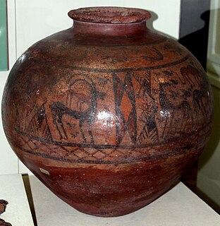
The Nakhchivan culture, also known as the Kizilveng culture or Painted Pottery culture, was formed during the Middle Bronze Age in the 3rd and 2nd millennium BC. The main center of painted pottery were Nakhchivan and the Arpachay Valley, in Anatolia, Urmia lake basin and the South Caucasus. In Azerbaijan, this culture was studied on the basis of archeological materials from the I Kultepe, II Kultepe, Shahtakhti, Gizilburun, Nahjir, Shortepe, Garachuk, II Gazanchi qala and other monuments. The painted pottery culture was studied by Azerbaijani archaeologists such as O. Habibullayev, V. Bakhshaliyev, V. Aliyev and A. Akbarov. According to V. Bakhshaliyev, the formation of this culture dishes in Nakhchivan was connected with the formation of the city states.