Granum, Alberta

Last updated
Granum
Leavings (1904–1908)
Hamlet of Granum
Alberta County Point Locator.svg
Red pog.svg
Granum
Location of Granum in Alberta
Coordinates: 49°52′25″N113°30′27″W / 49.87361°N 113.50750°W / 49.87361; -113.50750 Coordinates: 49°52′25″N113°30′27″W / 49.87361°N 113.50750°W / 49.87361; -113.50750
CountryCanada
Province Alberta
Region Southern Alberta
Census division 3
Municipal district Municipal District of Willow Creek No. 26
Incorporated [1]  
   Village July 12, 1904
  Name changeMarch 31, 1908
   Town November 7, 1910
Dissolution [2] February 1, 2020
Area
 (2021) [3]
  Land1.89 km2 (0.73 sq mi)
Elevation
[4]
991 m (3,251 ft)
Population
 (2021) [3]
  Total557
  Density295/km2 (760/sq mi)
Time zone UTC−7 (MST)
  Summer (DST) UTC−6 (MDT)
Highways Highway 2
Highway 519
Website Official website

Granum is a hamlet in southern Alberta, Canada that is under the jurisdiction of the Municipal District of Willow Creek No. 26. [5] It is located at the junction of Highway 2 and Highway 519 west of Lethbridge. Incorporated as the Village of Leavings in 1904, it changed its name to Granum in 1908 and held town status between late 1910 and early 2020.

Contents

History

The community originally incorporated as the Village of Leavings on July 12, 1904. [6] It was named The Leavings as it was the site on Willow Creek west of Pultney siding where the old Bull-team Freighters stopped for water and to unload freight. [7] Predating the railroads, it was where a trail left a river and travellers were reminded to bring water. [8] Leavings changed its name to Granum on March 31, 1908 and then incorporated as a town on November 7, 1910. [6] At a population of 447, Granum was Alberta's smallest town as of the 2016 census. [9] It dissolved from town status to become a hamlet under the jurisdiction of the Municipal District of Willow Creek No. 26 on February 1, 2020. [2]

Geography

Granum is located on the edge of the prairie and the foothills of the Canadian Rockies. Viewable from the community are the mountains of Waterton-Glacier International Peace Park to the south, of the Crowsnest Pass to the west, and of Kananaskis Country to the northwest.

Demographics

Historical population
YearPop.±%
1991 343    
1996 337−1.7%
2001 392+16.3%
2006 415+5.9%
2011 447+7.7%
2016 406−9.2%
2021 557+37.2%
Sources: [3]

In the 2021 Census of Population conducted by Statistics Canada, Granum recorded a population of 557 living in 190 of its 204 total private dwellings, a change of

In the 2016 Census of Population conducted by Statistics Canada, Granum recorded a population of 406 living in 199 of its 206 total private dwellings, a

Media

Historical newspapers

See also

Related Research Articles

New Norway Hamlet in Alberta, Canada

New Norway is a hamlet located in central Alberta, Canada within Camrose County. Named in 1895, it is located on Highway 21, approximately 100 km (62 mi) southeast of Edmonton and 22 km (14 mi) southwest of Camrose.

Ferintosh, Alberta Hamlet in Alberta, Canada

Ferintosh is a hamlet in central Alberta, Canada within Camrose County. It is located approximately 38 kilometres (24 mi) south of Camrose, and 102 kilometres (63 mi) southeast of Edmonton. The hamlet is situated on Little Beaver Lake. The community takes its name from Ferintosh, in Scotland.

Claresholm Town in Alberta, Canada

Claresholm is a town located within southern Alberta, Canada. It is located on Highway 2, approximately 91 km (57 mi) northwest of the City of Lethbridge and 125 km (78 mi) south of the City of Calgary.

Division No. 3, Alberta Census division in Alberta, Canada

Division No. 3 is a census division in Alberta, Canada. It is located in the southwest corner of southern Alberta and its largest urban community is the Town of Claresholm.

Cereal, Alberta Hamlet in Alberta, Canada

Cereal is a hamlet within Special Area No. 3 in central Alberta, Canada. It is approximately 161 km (100 mi) east of Drumheller. It was named after the post office that was established in the area in 1910. The name of the post office alluded to grain fields near the community. Cereal held village status prior to 2021.

Gadsby, Alberta Hamlet in Alberta, Canada

Gadsby is a hamlet in central Alberta, Canada that is under the jurisdiction of the County of Stettler No. 6. It is located east of Red Deer on Highway 852 just north of Highway 12. Incorporated in 1909, it dissolved from village status in early 2020.

Nobleford Municipality in Alberta, Canada (est. 1909)

Nobleford is a town in southern Alberta, Canada that is approximately 32 km (20 mi) northwest of the City of Lethbridge. It has emerged as a bedroom community of Lethbridge.

Strome, Alberta Hamlet in Alberta, Canada

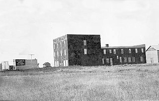
Strome is a hamlet in east-central Alberta, Canada, within Flagstaff County. It is located on Highway 13, approximately 58 km (36 mi) east of the City of Camrose. The hamlet was originally incorporated as a village on February 3, 1910. It dissolved to become a hamlet under the jurisdiction of Flagstaff County on January 1, 2016. Strome's name is believed to come from Stromeferry in Ross & Cromarty, Scotland.

Tilley, Alberta Hamlet in Alberta, Canada

Tilley is a hamlet in southern Alberta, Canada within the County of Newell. It is located approximately 22 km southeast of the City of Brooks and 78 km northwest of the City of Medicine Hat.

Municipal District of Willow Creek No. 26 Municipal district in Alberta, Canada

The Municipal District of Willow Creek No. 26 is a municipal district (MD) in southern Alberta, Canada. Located in Census Division No. 3, its municipal office is located adjacent to Claresholm Industrial Airport, west of the Town of Claresholm.

Gleichen, Alberta Hamlet in Alberta, Canada

Gleichen is a hamlet in southeast Alberta, Canada within Wheatland County. It is located adjacent to the Siksika Nation at the intersection of Highway 1 and Highway 547, approximately 40 kilometres (25 mi) southeast of Strathmore. It has an elevation of 903 m (2,963 ft).

Lundbreck Hamlet in Alberta, Canada

Lundbreck is a hamlet in southern Alberta, Canada within the Municipal District of Pincher Creek No. 9. It is located on the south side of Highway 3, approximately 3 kilometres (1.9 mi) east of the southern terminus of Highway 22, 16 km (9.9 mi) east of the Municipality of Crowsnest Pass, 4 km (2.5 mi) west of the Village of Cowley and 16 km (9.9 mi) west of the Town of Pincher Creek. It has an elevation of 1,200 m (3,900 ft).

Anzac, Alberta Hamlet in Alberta, Canada

Anzac is a hamlet in northern Alberta, Canada within the Regional Municipality (RM) of Wood Buffalo. It is located on Highway 881 along the east shore of Gregoire Lake, approximately 36 kilometres (22 mi) southeast of Fort McMurray.

Red Earth Creek Hamlet in Alberta, Canada

Red Earth Creek is a hamlet in Alberta, Canada within the Municipal District of Opportunity No. 17. It is located east of Highway 88, between the Town of Slave Lake and the Hamlet of Fort Vermilion, and has an elevation of 520 metres (1,710 ft).

Red Willow, Alberta Hamlet in Alberta, Canada

Red Willow is a hamlet in central Alberta, Canada within the County of Stettler No. 6. It is located on Highway 850, approximately 16 kilometres (9.9 mi) northeast of Stettler and 14 kilometres (8.7 mi) south of Donalda. It has an elevation of 785 metres (2,575 ft).

Canyon Creek, Alberta Hamlet in Alberta, Canada

Canyon Creek is a hamlet in northern Alberta, Canada within the Municipal District of Lesser Slave River No. 124. It is located on Highway 2, approximately 234 kilometres (145 mi) east of Grande Prairie.

Moon River Estates Hamlet in Alberta, Canada

Moon River Estates is a hamlet in southern Alberta, Canada within the Municipal District of Willow Creek No. 26 that was declared on October 17, 1984. It is located 6 kilometres (3.7 mi) south of Highway 3, approximately 22 kilometres (14 mi) west of Lethbridge.

Orton, Alberta Hamlet in Alberta, Canada

Orton is a hamlet in southern Alberta, Canada within the Municipal District of Willow Creek No. 26. It is located 6 kilometres (3.7 mi) south of Highway 3, approximately 31 kilometres (19 mi) west of Lethbridge.

Pincher Station Hamlet in Alberta, Canada

Pincher Station, once known as Pincher City, is a hamlet in southern Alberta, Canada within the Municipal District of Pincher Creek No. 9. It is located on Highway 3, approximately 83 kilometres (52 mi) southwest of Lethbridge. Previously an incorporated community, Pincher City dissolved from village status on May 3, 1932.

Saprae Creek Hamlet in Alberta, Canada

Saprae Creek is a hamlet in northern Alberta, Canada within the Regional Municipality (RM) of Wood Buffalo. It is located 3 kilometres (1.9 mi) north of Highway 69, approximately 11 kilometres (6.8 mi) east of Fort McMurray.

References

  1. "Location and History Profile: Town of Granum" (PDF). Alberta Municipal Affairs. October 7, 2016. p. 281. Retrieved October 16, 2016.
  2. 1 2 "O.C. 17/2020". Government of Alberta. January 28, 2020. Retrieved February 1, 2020.
  3. 1 2 3 4 "Population and dwelling counts: Canada and designated places". Statistics Canada. February 9, 2022. Retrieved February 10, 2022.
  4. "Alberta Private Sewage Systems 2009 Standard of Practice Handbook: Appendix A.3 Alberta Design Data (A.3.A. Alberta Climate Design Data by Town)" (PDF) (PDF). Safety Codes Council. January 2012. pp. 212–215 (PDF pages 226–229). Retrieved October 8, 2013.
  5. "Specialized and Rural Municipalities and Their Communities" (PDF). Alberta Municipal Affairs. January 12, 2022. Retrieved January 21, 2022.
  6. 1 2 "Location and History Profile: Town of Granum". Alberta Municipal Affairs. June 14, 2013. Retrieved June 17, 2013.
  7. Leavings by trail, Granum by rail. Granum, Alberta: Granum History Committee. 1977. p. 10.
  8. Douglas, Helen (1965). Echoes of Willow Creek. Granum, Alberta: Willow Creek Historical Society. p. 9.
  9. 1 2 "Population and dwelling counts, for Canada, provinces and territories, and census subdivisions (municipalities), 2016 and 2011 censuses – 100% data (Alberta)". Statistics Canada. February 8, 2017. Retrieved February 8, 2017.
  10. 1 2 Strathern, Gloria M. (1988). Alberta Newspapers, 1880-1982: An Historical Directory. University of Alberta Press. pp. 137–138. ISBN   0-88864-137-0.