The Saulteaux, otherwise known as the Plains Ojibwe, are a First Nations band government in Ontario, Manitoba, Saskatchewan, Alberta and British Columbia, Canada. They are a branch of the Ojibwe who pushed west. They formed a mixed culture of woodlands and plains Indigenous customs and traditions.
In Canada, an Indian reserve is specified by the Indian Act as a "tract of land, the legal title to which is vested in Her Majesty, that has been set apart by Her Majesty for the use and benefit of a band." Indian reserves are the areas set aside for First Nations, an indigenous Canadian group, after a contract with the Canadian state, and are not to be confused with land claims areas, which involve all of that First Nations' traditional lands: a much larger territory than any reserve.
Treaty 3 was an agreement entered into on October 3, 1873, by Chief Mikiseesis on behalf of the Ojibwe First Nations and Queen Victoria. The treaty involved a vast tract of Ojibwe territory, including large parts of what is now northwestern Ontario and a small part of eastern Manitoba, to the Government of Canada. Treaty 3 also provided for rights for the Waasaakode Anishinaabe and other Ojibwe, through a series of agreements signed over the next year. The treaty was modified in 1875 when Nicolas Chatelain negotiated an adhesion that created a reserve, surveyed as reserve 16A, for Metis families connected to Mikiseesis' Rainy Lake Band. Reserve 16A and the Rainy Lake Band reserve were unified in 1967.
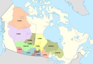
The Numbered Treaties are a series of eleven treaties signed between the First Nations, one of three groups of Indigenous peoples in Canada, and the reigning monarch of Canada from 1871 to 1921. These agreements were created to allow the Government of Canada to pursue settlement and resource extraction in the affected regions, which include modern-day Alberta, British Columbia, Manitoba, Ontario, Saskatchewan, and the Northwest Territories. These treaties expanded the Dominion of Canada with large tracts of land in exchange for promises made to the indigenous people of the area. These terms were dependent on individual negotiations and so specific terms differed with each treaty.
Asubpeeschoseewagong First Nation is an Ojibwe First Nations band government who inhabit northern Kenora in Ontario, Canada. Their landbase is the 4,145 ha English River 21 Indian Reserve. It has a registered population of 1,595 as of October 2019, of which the on-reserve population was 971. As of October 2020, the community had a population of approximately 1,200. They are a signatory to Treaty 3.

The Grand River land dispute, also known as the Caledonia land dispute, is an ongoing dispute between the Six Nations of the Grand River and the Government of Canada. It is focussed on lands along the length of the Grand River in Ontario known as the Haldimand Tract, an 385,000 hectares tract that was granted to Indigenous allies of the British Crown in 1784 to make up for territorial losses suffered as a result of the American Revolutionary War and the Treaty of Paris (1783). The Six Nations were granted the land in perpetuity and allege that lands were improperly sold, leased or given away by various Canadian governments, leaving only 5 per cent of the original lands under Six Nations control. The Six Nations also allege that monies owed to the Six Nations from leases and loans on much of the tract have not been paid or were redirected into government coffers.
The Burnt Church Crisis was a conflict in Canada between the Mi'kmaq people of the Burnt Church First Nations (Esgenoôpetitj) and non-Aboriginal fisheries in New Brunswick and Nova Scotia between 1999 and 2002.
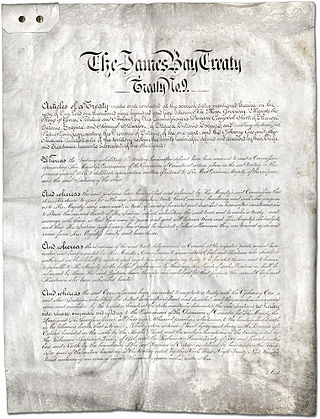
Treaty No. 9 is a numbered treaty first signed in 1905-1906 between Anishinaabe and Omushkegowuk Cree communities and the Canadian Crown, which includes both the government of Canada and the government of the province of Ontario. It is commonly known as the "James Bay Treaty," since the eastern edge of the treaty territory is the shore of James Bay in Northern Ontario.
Ontario Minamata disease is a neurological syndrome caused by severe mercury poisoning. It occurred in the Canadian province of Ontario, in 1970, and severely affected two First Nation communities in Northwestern Ontario following consumption of local fish contaminated with mercury, and one First Nation in Southern Ontario due to illegal disposal of industrial chemical waste. The disease was named after the infamous case of severe mercury poisoning in the fishing community of Minamata, Japan, which became known as Minamata disease because it devastated only the residents of the community.

The Teme-Augama Anishnabai is the Indigenous Anishinaabe community of the Temagami First Nation. The Teme-Augama Anishnabai have trapped and hunted animals in the Temagami region of Canada for over 5,000 years. Bear Island on Lake Temagami is home to the Aboriginal community.
Wabaseemoong Independent Nations or more fully as the Wabaseemoong Independent Nations of One Man Lake, Swan Lake and Whitedog, is an Ojibway First Nation band government who reside 120 km northwest of Kenora, Ontario and 13 kilometres (8.1 mi) east of the Ontario-Manitoba border of northwestern Ontario, Canada. As of December 2018, the First Nation had a population of 2,000 registered people, of which their on-Reserve population was 1200 registered members and approximately 100 non-Band members.

Long Lake 58 First Nation is an Anishinaabe (Ojibway) First Nation band government located in Northern Ontario, located approximately 40 km east of Geraldton, Ontario, Canada, on the northern shore of Long Lake, immediately north of Ginoogaming First Nation and west of the community of Longlac, Ontario. As of January, 2008, their total registered population was 1,248 people, of which their on-Reserve population was 427.
Grand Council of Treaty 3 (GCT3) is a political organization representing 24 First Nation communities across Treaty 3 areas of northern Ontario and southeastern Manitoba, Canada, and four additional First Nations, specifically in regard to their Treaty rights.
The Anishinaabe Nation in Treaty No. 3 is a sovereign Anishinaabe Nation in Canada. It has existed as a self-governing people with its own laws and government institutions since time immemorial, before the arrival of European settlers. "America, separated from Europe by a wide ocean, was inhabited by ... separate nations, independent of each other and of the rest of the world, having institutions of their own, and governing themselves by their own laws." "The territory included in Treaty #3 in 1873 was governed by a Grand Council of Anishinaabe Chiefs. ... This civil leadership was responding to other political ranks and ultimately to the constituent families." The Nation is, by constitutional definition, the Anishinaabe people that entered into Treaty 3 with the Crown in 1873.
Waawaate Fobister (Anishinaabe) is a Canadian actor, dancer, playwright, choreographer, instructor, producer and storyteller, best known for their semi-autobiographical one-man play, Agokwe.
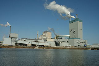
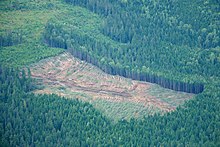
The Dryden pulp mill, also known as the Reed Mill, is a paper and pulp mill in Dryden, Ontario. During the 1960s and 70s, mercury poisoning from the mill caused one of Canada's worst environmental disasters: Dryden Chemicals Ltd dumped mercury into the English-Wabigoon River, upstream of Grassy Narrows First Nation, poisoning the fish which were their staple food. Members of the Grassy Narrows and the Whitedog communities downstream from the mill suffered severe mercury poisoning.

Birch Narrows Dene Nation is a Dene First Nation band government in the boreal forest region of northern Saskatchewan, Canada. It is affiliated with the Meadow Lake Tribal Council (MLTC).

Restoule v Canada is a legal case in the Ontario Superior Court of Justice that considers whether the Augmentation clause in the 1850 Robinson Treaties entitles the Anishinaabe to an increase in annuity payments.

Grassy Narrows First Nation v. Ontario [2014] SCR 48, [2014] 2 S.C.R. 447 was a July 11, 2014 decision by the Supreme Court of Canada in case number 35379 in which an appeal made by the Government of Ontario was allowed. The result of Grassy Narrows v. Ontario, while legal, was deemed unfair by some to Grassy Narrows First Nation, as "it has put them in a situation of having negotiated with a party who then ceased to be a party when it came to honouring the agreement."
Mercury contamination in Grassy Narrows was an uncontrolled discharge of between 9,000 kilograms (20,000 lb) and 11,000 kilograms (24,000 lb) of mercury from the Dryden Mill's chloralkali plant in Dryden into the headwaters of the Wabigoon River in the Kenora District of Northwestern Ontario from 1962 until 1970. It was described as "one of the worst cases of environmental poisoning in Canadian history." The contamination poisoned many people in the Grassy Narrows First Nation and Whitedog First Nation communities