Gregory, South Dakota

Last updated

Gregory, South Dakota
Gregory, SD W side Main St from 5th St.JPG
Main Street
Gregory County South Dakota Incorporated and Unincorporated areas Gregory Highlighted.svg
Location in Gregory County and the state of South Dakota
Coordinates: 43°13′48″N99°25′15″W / 43.23000°N 99.42083°W / 43.23000; -99.42083 [1]
CountryUnited States
State South Dakota
County Gregory
IncorporatedDecember 7, 1908 [2]
Government
  TypeAldermanic Form
  MayorScott Anshutz
  City AdministratorAlex Hamilton
  Ward IKristi Drey, Shana Flaukas
  Ward IISeymour Studenberg, Cory Graber
  Ward IIIAshley Lozano, Guyla Husman
Area
[3]
  Total1.72 sq mi (4.46 km2)
  Land1.72 sq mi (4.46 km2)
  Water0.00 sq mi (0.00 km2)
Elevation
[1]
2,169 ft (661 m)
Population
 (2020) [4]
  Total1,221
  Density709.47/sq mi (273.92/km2)
Time zone UTC−6 (Central (CST))
  Summer (DST) UTC−5 (CDT)
ZIP code
57533
Area code 605
FIPS code 46-26180 [5]
GNIS feature ID1267408 [1]
Website http://www.cityofgregory.com/

Gregory is a city in western Gregory County, South Dakota, United States. The population was 1,221 at the 2020 census. [6]

Contents

History

Gregory was laid out in 1904. [7] The city took its name from its location in Gregory County. [8] A post office called Gregory has been in operation since 1904. [8] The local paper for Gregory and the surrounding county, the Gregory Times-Advocate, was founded in 1910. [9]

On May 8, 1965, an F5 tornado touched down on the town without causing any fatalities.

Geography

Gregory is located along U.S. Route 18 and South Dakota Highway 47 between Burke, seven miles to the southeast and Dallas, four miles to the west. Ponca Creek flows past Gregory, two miles to the south and the headwaters of South Fork Whetstone Creek lie to the northeast. [10]

According to the United States Census Bureau, the city has a total area of 1.71 square miles (4.43 km2), all land. [11]

Climate

Climate data for Gregory, South Dakota (1991−2020 normals, extremes 1906−present)
MonthJanFebMarAprMayJunJulAugSepOctNovDecYear
Record high °F (°C)71
(22)
76
(24)
91
(33)
98
(37)
103
(39)
107
(42)
114
(46)
113
(45)
105
(41)
97
(36)
85
(29)
79
(26)
114
(46)
Mean maximum °F (°C)57.0
(13.9)
61.1
(16.2)
74.9
(23.8)
82.0
(27.8)
88.9
(31.6)
93.6
(34.2)
100.3
(37.9)
98.2
(36.8)
93.7
(34.3)
85.2
(29.6)
72.2
(22.3)
57.9
(14.4)
101.2
(38.4)
Average high °F (°C)31.6
(−0.2)
35.9
(2.2)
46.8
(8.2)
57.6
(14.2)
68.8
(20.4)
79.6
(26.4)
86.6
(30.3)
84.7
(29.3)
76.7
(24.8)
61.6
(16.4)
46.8
(8.2)
34.5
(1.4)
59.3
(15.2)
Daily mean °F (°C)20.9
(−6.2)
24.5
(−4.2)
34.7
(1.5)
45.4
(7.4)
56.9
(13.8)
67.8
(19.9)
74.2
(23.4)
72.0
(22.2)
63.1
(17.3)
48.7
(9.3)
34.9
(1.6)
24.2
(−4.3)
47.3
(8.5)
Average low °F (°C)10.1
(−12.2)
13.1
(−10.5)
22.5
(−5.3)
33.3
(0.7)
45.0
(7.2)
55.9
(13.3)
61.7
(16.5)
59.3
(15.2)
49.6
(9.8)
35.7
(2.1)
23.0
(−5.0)
13.8
(−10.1)
35.3
(1.8)
Mean minimum °F (°C)−12.1
(−24.5)
−7.9
(−22.2)
0.0
(−17.8)
17.0
(−8.3)
30.2
(−1.0)
43.0
(6.1)
50.2
(10.1)
47.2
(8.4)
33.7
(0.9)
18.4
(−7.6)
4.4
(−15.3)
−8.2
(−22.3)
−17.6
(−27.6)
Record low °F (°C)−31
(−35)
−28
(−33)
−25
(−32)
−4
(−20)
16
(−9)
32
(0)
35
(2)
33
(1)
20
(−7)
3
(−16)
−24
(−31)
−36
(−38)
−36
(−38)
Average precipitation inches (mm)0.55
(14)
0.75
(19)
1.34
(34)
3.12
(79)
4.13
(105)
4.18
(106)
2.99
(76)
3.14
(80)
2.41
(61)
2.36
(60)
0.95
(24)
0.74
(19)
26.66
(677)
Average snowfall inches (cm)6.8
(17)
8.5
(22)
5.3
(13)
5.4
(14)
0.0
(0.0)
0.0
(0.0)
0.0
(0.0)
0.0
(0.0)
0.0
(0.0)
1.7
(4.3)
6.9
(18)
10.4
(26)
45.0
(114)
Average precipitation days (≥ 0.01 in)3.44.35.48.210.410.07.47.16.36.04.24.076.7
Average snowy days (≥ 0.1 in)2.93.62.41.40.00.00.00.00.00.61.83.115.8
Source: NOAA [12] [13]

Demographics

Historical population
CensusPop.Note
1910 1,142
1920 1,067−6.6%
1930 1,034−3.1%
1940 1,24620.5%
1950 1,37510.4%
1960 1,4787.5%
1970 1,75618.8%
1980 1,503−14.4%
1990 1,486−1.1%
2000 1,342−9.7%
2010 1,295−3.5%
2020 1,221−5.7%
U.S. Decennial Census [14] [4]

2010 census

As of the census [15] of 2010, there were 1,295 people, 611 households, and 326 families living in the city. The population density was 757.3 inhabitants per square mile (292.4/km2). There were 730 housing units at an average density of 426.9 per square mile (164.8/km2). The racial makeup of the city was 90.3% White, 0.2% African American, 6.8% Native American, 0.6% Asian, and 2.2% from two or more races. Hispanic or Latino of any race were 0.8% of the population.

There were 611 households, of which 23.9% had children under the age of 18 living with them, 39.4% were married couples living together, 10.5% had a female householder with no husband present, 3.4% had a male householder with no wife present, and 46.6% were non-families. 43.7% of all households were made up of individuals, and 25.9% had someone living alone who was 65 years of age or older. The average household size was 2.05 and the average family size was 2.82.

The median age in the city was 48.5 years. 21.8% of residents were under the age of 18; 6.8% were between the ages of 18 and 24; 17% were from 25 to 44; 28.1% were from 45 to 64; and 26.3% were 65 years of age or older. The gender makeup of the city was 47.8% male and 52.2% female.

2000 census

As of the census [5] of 2000, there were 1,342 people, 613 households, and 351 families living in the city. The population density was 982.6 inhabitants per square mile (379.4/km2). There were 718 housing units at an average density of 525.7 per square mile (203.0/km2). The racial makeup of the city was 95.68% White, 3.28% Native American, 0.07% Asian, 0.07% from other races, and 0.89% from two or more races. Hispanic or Latino of any race were 0.89% of the population.

There were 613 households, out of which 25.0% had children under the age of 18 living with them, 47.5% were married couples living together, 7.2% had a female householder with no husband present, and 42.6% were non-families. 40.0% of all households were made up of individuals, and 26.6% had someone living alone who was 65 years of age or older. The average household size was 2.19 and the average family size was 2.94.

In the city, the population was spread out, with 24.0% under the age of 18, 4.4% from 18 to 24, 21.7% from 25 to 44, 22.0% from 45 to 64, and 27.9% who were 65 years of age or older. The median age was 45 years. For every 100 females, there were 84.1 males. For every 100 females age 18 and over, there were 78.9 males.

As of 2000 the median income for a household in the city was $23,173, and the median income for a family was $31,250. Males had a median income of $25,057 versus $16,923 for females. The per capita income for the city was $13,626. About 12.9% of families and 18.8% of the population were below the poverty line, including 25.9% of those under age 18 and 20.7% of those age 65 or over.

Notable person

See also

Related Research Articles

<span class="mw-page-title-main">Tyndall, South Dakota</span> City in South Dakota, United States

Tyndall is a city in and the county seat of Bon Homme County, South Dakota, United States. The population was 1,057 at the 2020 census.

<span class="mw-page-title-main">Chamberlain, South Dakota</span> City in South Dakota, United States

Chamberlain is a city in Brule County, South Dakota, United States. It is located on the east bank of the Missouri River, at the dammed section of the Lake Francis Case, close to where it is crossed by Interstate 90.

<span class="mw-page-title-main">Newell, South Dakota</span> City in South Dakota, United States

Newell is a city in Butte County, South Dakota, United States. The population was 584 at the 2020 census.

<span class="mw-page-title-main">Wagner, South Dakota</span> City in South Dakota, United States

Wagner is a city in Charles Mix County, South Dakota, United States. The population was 1,490 at the 2020 census. The city is served by Wagner Municipal Airport as well as YST Transit buses.

<span class="mw-page-title-main">Clear Lake, South Dakota</span> City in South Dakota, United States

Clear Lake is a city in and the county seat of Deuel County, South Dakota, United States. The population was 1,218 at the 2020 census.

<span class="mw-page-title-main">Bonesteel, South Dakota</span> City in South Dakota, United States

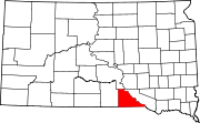
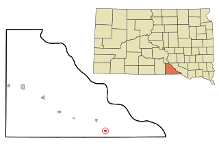
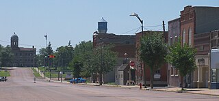
Bonesteel is a city in Gregory County, South Dakota, United States. The population was 258 at the 2020 census.

<span class="mw-page-title-main">Burke, South Dakota</span> City in South Dakota, United States

Burke is a city in and county seat of Gregory County, South Dakota, United States. The population was 575 at the 2020 census.

<span class="mw-page-title-main">Dallas, South Dakota</span> Town in South Dakota, United States

Dallas is a town in Gregory County, South Dakota, United States. The population was 89 at the 2020 census.

<span class="mw-page-title-main">Fairfax, South Dakota</span> Town in South Dakota, United States

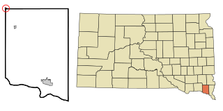
Fairfax is a town in southeastern Gregory County, South Dakota, United States. The population was 96 at the 2020 census.

<span class="mw-page-title-main">Miller, South Dakota</span> City in South Dakota, United States

Miller is a city in and county seat of Hand County, South Dakota, United States. The population was 1,349 at the 2020 census.

<span class="mw-page-title-main">Alexandria, South Dakota</span> City in South Dakota, United States

Alexandria is a city in central Hanson County, South Dakota, United States. The population was 649 at the 2020 census. It is the county seat of Hanson County.

<span class="mw-page-title-main">Parkston, South Dakota</span> City in South Dakota, United States

Parkston is a city in Hutchinson County, South Dakota, United States. The population was 1,567 at the 2020 census.

<span class="mw-page-title-main">Central City, South Dakota</span> City in South Dakota, United States

Central City is a city in Lawrence County, South Dakota, United States. The population was 93 at the 2020 census.

<span class="mw-page-title-main">Whitewood, South Dakota</span> City in South Dakota, United States

Whitewood is a city in Lawrence County, South Dakota, United States. The population was 879 at the 2020 census.

<span class="mw-page-title-main">Leola, South Dakota</span> City in South Dakota, United States

Leola is a small city in, and the county seat of, McPherson County, South Dakota, United States. It was founded on May 1, 1884, and named for Leola Haynes, daughter of one of the town's founders. The population was 434 as of the 2020 census.

<span class="mw-page-title-main">Hartford, South Dakota</span> City in South Dakota, United States

Hartford is a suburban American city in Minnehaha County, South Dakota, a few miles northwest of Sioux Falls. Its population was 3,354 at the 2020 census.

<span class="mw-page-title-main">Mission, South Dakota</span> City in South Dakota, United States

Mission is a city on the Rosebud Indian Reservation in northern Todd County, South Dakota, United States. The population was 1,156 at the 2020 census.

<span class="mw-page-title-main">Parker, South Dakota</span> City in South Dakota, U.S.

Parker is a city in Turner County, South Dakota, United States. The population was 1,194 at the 2020 census. It is the county seat of Turner County. Parker is bordered on its eastern side by South Dakota State Highway 19. Its northern side is bordered by South Dakota State Highway 44. Parker is located approximately 8 miles (13 km) northwest of Chancellor, 42 miles (68 km) east of Parkston and 41 miles (66 km) south of Madison.

<span class="mw-page-title-main">Viborg, South Dakota</span> City in South Dakota, United States

Viborg is a city in Turner County, South Dakota, United States. The population was 814 at the 2020 census.

<span class="mw-page-title-main">Irene, South Dakota</span> City in South Dakota, United States

Irene is a city in Clay, Turner, and Yankton counties in South Dakota, United States. The population was 422 at the 2020 census. The portion of Irene that is located in Turner County is a part of the Sioux Falls, South Dakota metropolitan area, the portion located in Yankton County is part of the Yankton Micropolitan Statistical Area, and the portion located in Clay County is part of both the Vermillion Micropolitan Statistical Area and the Sioux City-Vermillion Combined Statistical Area. Irene is also host to the Irene Rodeo, held every summer.

References

  1. 1 2 3 U.S. Geological Survey Geographic Names Information System: Gregory, South Dakota
  2. "SD Towns" (PDF). South Dakota State Historical Society. Archived from the original (PDF) on February 10, 2010. Retrieved February 12, 2010.
  3. "ArcGIS REST Services Directory". United States Census Bureau. Retrieved October 15, 2022.
  4. 1 2 "Census Population API". United States Census Bureau. Retrieved October 15, 2022.
  5. 1 2 "U.S. Census website". United States Census Bureau . Retrieved January 31, 2008.
  6. "U.S. Census Bureau: Gregory city, South Dakota". www.census.gov. United States Census Bureau. Retrieved December 28, 2021.
  7. Federal Writers' Project (1940). South Dakota place-names, v.1-3. University of South Dakota. p. 40.
  8. 1 2 Chicago and North Western Railway Company (1908). A History of the Origin of the Place Names Connected with the Chicago & North Western and Chicago, St. Paul, Minneapolis & Omaha Railways. p. 79.
  9. Library of Congress, Chronicling America. Record for Gregory Times-Advocate, Retrieved 8 June 2016.
  10. Gregory, SD, 7.5 Minute Topographic Quadrangle, USGS, 1964
  11. "US Gazetteer files 2010". United States Census Bureau. Archived from the original on January 25, 2012. Retrieved June 21, 2012.
  12. "NowData - NOAA Online Weather Data". National Oceanic and Atmospheric Administration. Retrieved October 18, 2021.
  13. "Station: Gregory, SD". U.S. Climate Normals 2020: U.S. Monthly Climate Normals (1991-2020). National Oceanic and Atmospheric Administration. Retrieved October 18, 2021.
  14. United States Census Bureau. "Census of Population and Housing" . Retrieved June 7, 2016.
  15. "U.S. Census website". United States Census Bureau . Retrieved June 21, 2012.
  16. "Newsroom | South Dakota Tourism Industry" . Retrieved February 23, 2019.

Commons-logo.svg Media related to Gregory, South Dakota at Wikimedia Commons