
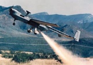
The General Atomics MQ-1 Predator is an American remotely piloted aircraft (RPA) built by General Atomics that was used primarily by the United States Air Force (USAF) and Central Intelligence Agency (CIA). Conceived in the early 1990s for aerial reconnaissance and forward observation roles, the Predator carries cameras and other sensors. It was modified and upgraded to carry and fire two AGM-114 Hellfire missiles or other munitions. The aircraft entered service in 1995, and saw combat in the war in Afghanistan, Pakistan, the NATO intervention in Bosnia, the NATO bombing of Yugoslavia, the Iraq War, Yemen, the 2011 Libyan civil war, the 2014 intervention in Syria, and Somalia.
The IAI RQ-5 Hunter unmanned aerial vehicle (UAV) was originally intended to serve as the United States Army's Short Range UAV system for division and corps commanders. It took off and landed on runways. It used a gimbaled EO/IR sensor to relay its video in real time via a second airborne Hunter over a C-band line-of-sight data link. The RQ-5 is based on the Hunter UAV that was developed by Israel Aerospace Industries.

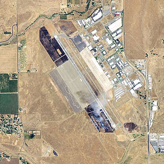
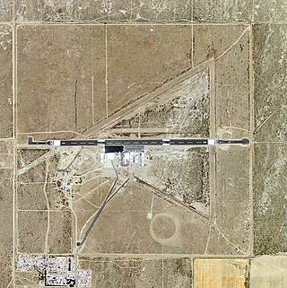
The Tonopah Test Range is a highly classified, restricted military installation of the United States Department of Defense, and United States Department of Energy located about 30 miles (48 km) southeast of Tonopah, Nevada. It is part of the northern fringe of the Nellis Range, measuring 625 sq mi (1,620 km2). Tonopah Test Range is located about 70 miles (110 km) northwest of Groom Lake, the home of the Area 51 facility.

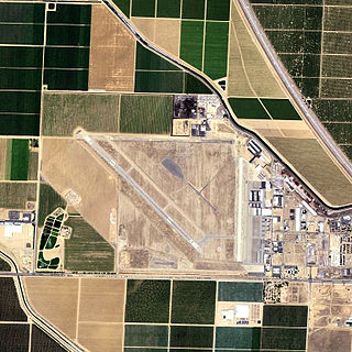
Palmdale Regional Airport is an airport in Palmdale, California, United States. The city of Palmdale took over the airport at the end of 2013, managing it via the Palmdale Airport Authority. The airport currently does not have any scheduled passenger airline service.

Naval Air Station Alameda was a United States Navy Naval Air Station in Alameda, California, on San Francisco Bay.
Chico Regional Airport, formerly known as Chico Municipal Airport, is four miles (6 km) north of Chico, in Butte County, California, United States. The airport covers 1,475 acres (6.0 km2), has two runways and one helipad. Its fixed-base operator, Northgate Aviation provides fuel, maintenance, flight training, and charter flights. Though an operational airport with that meets Federal Aviation Regulations Part 139 standards, the airport has not seen active commercial air service since SkyWest Airlines ended service to San Francisco at the end of 2014.
Creech Air Force Base is a United States Air Force (USAF) command and control facility in Clark County, Nevada used "to engage in daily Overseas Contingency Operations …of remotely piloted aircraft systems which fly missions across the globe." In addition to an airport, the military installation has the Unmanned Aerial Vehicle Battlelab, associated aerial warfare ground equipment, and unmanned aerial vehicles of the type used in Afghanistan and Iraq. Creech is the aerial training site for the USAF Thunderbirds and "is one of two emergency divert airfields" for the Nevada Test and Training Range.
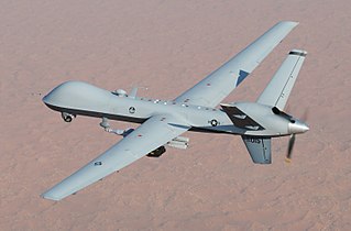
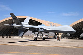
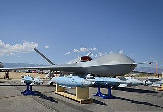
The General Atomics MQ-9 Reaper is an unmanned aerial vehicle capable of remotely controlled or autonomous flight operations, developed by General Atomics Aeronautical Systems (GA-ASI) primarily for the United States Air Force (USAF). The MQ-9 and other UAVs are referred to as Remotely Piloted Vehicles/Aircraft (RPV/RPA) by the USAF to indicate ground control by humans.
Shafter Airport, also known as Minter Field and formerly known as Air Corps Basic Flying School, is a public use airport located four nautical miles east of the central business district of Shafter and 14 miles northwest of Bakersfield, a city in Kern County, California, United States. Originally a World War II primary training facility for pilots, it is currently a public airport owned by the Minter Field Airport District. This airport is included in the National Plan of Integrated Airport Systems for 2011–2015, which categorized it as a general aviation facility.

The General Atomics MQ-1C Gray Eagle is a medium-altitude, long-endurance (MALE) unmanned aircraft system (UAS). It was developed by General Atomics Aeronautical Systems (GA-ASI) for the United States Army as an upgrade of the General Atomics MQ-1 Predator.
The General Atomics MQ-20 Avenger is a developmental unmanned combat aerial vehicle built by General Atomics Aeronautical Systems for the U.S. military.
Gjadër Air Base is a military airport located in Gjadër, Lezhë County, Albania. It is north of the city of Lezhë and is also known as Lezhë-Zadrima Air Base.
The Northrop Grumman AN/ZPY-1 STARLite Small Tactical Radar - Lightweight is a small, lightweight synthetic aperture radar/GMTI radar used in tactical operations. The radar is under contract to the U.S. Army Communications and Electronics Command for its ERMP General Atomics MQ-1C Gray Eagle Unmanned Aerial System and is manufactured by Northrop Grumman. STARLite weighs 65 lb (29 kg)., occupies 1.2 cubic feet (34 L), and requires less than 750 W of power. The Army began to take delivery of the system in 2010. Also in 2010 the system was ready for deployment to the battlefield.

Eagle Field is a privately owned, private use airport in Fresno County, California, United States. It is located seven nautical miles southwest of the central business district of Dos Palos, a city in neighboring Merced County.
El Mirage Field is a private airport located 3 miles west of El Mirage, California. It is leased by General Atomics of San Diego. Its primary use is the development and testing of unmanned aerial vehicles (UAV) for the United States military and US Government.
United States Air Force Plant 42 is a classified aircraft manufacturing plant owned by the United States Air Force in the Antelope Valley, about 60 miles from downtown Los Angeles. It is also used by the National Aeronautics and Space Administration (NASA).

California during World War II was a major contributor to the World War II effort. California's long Pacific Ocean coastline provided the support needed for the Pacific War. California also supported the war in Europe. After the Japanese attack on Pearl Harbor on December 7, 1941, most of California's manufacturing was shifted to the war effort. California became a major ship builder and aircraft manufacturer. Existing military installations were enlarged and many new ones were built. California trained many of the troops before their oversea deployment. Over 800,000 Californians served in the United States Armed Forces. California agriculture, ranches and farms were used to feed the troops around the world. California's long coastline also put the state in fear, as an attack on California seemed likely. California was used for the temporary and permanent internment camps for Japanese Americans. The population grew significantly, largely due to servicemen who were stationed at the new military bases/training facilities and the mass influx of workers from around the U.S. in the growing defense industries. With all the new economy activity, California was lifted out of the Great Depression. Over 500,000 people moved to California from other states to work in the growing economy. California expanded its oil and mineral production to keep up with the war demand.

Helm Field also called Lemoore Auxiliary Army Airfield A-7 is a former US Army Airfield use for training during World War II. Helm Field was location in the town of Coalinga, California, 70 miles south of Fresno. Helm Field had two 3,000 foot runways, one oriented east/west and one oriented northwest/southeast. The Airfield was on a 773 acres site of form farm land. The US Army purchased the land on January 11, 1943 for training pilots. The Airfield was used by the Lemoore Basic Flying School, based at the Lemoore Army Air Field. Helm Field was 15 miles northwest of Lemoore Army Air Field. The Army built at Helm Field to support training stage house, control tower, motor pool building, crash truck shelter and latrines. Helm Field was used by Air Corps Basic Flying School, the AAF Basic Flying School, the AAF Pilot School, the 88th Air Base Squadron, the 3023rd Army Air Force Pilot School and the 461st Army Air Force Base Unit. The army closed Helm Field on October 15, 1844 and the Airfield was sold by the War Assets Administration. Helm Field was used as a farm labor camp in the 1950s. The east/west runway was returned to farmland. The northwest/southeast runway was still intact and was used as a civilian airfield till 1971.

Victorville Army Airfield auxiliary fields were four airfields used during World War II to support the Victorville Army Airfield pilot training near Victorville, California, and Adelanto, California. After the war the Victorville Army Airfield was renamed George Air Force Base on January 13, 1948. The airfields were built in 1941 by the United States Army Air Corps just before the war. Victorville Army Airfield covered 2,200-acre in the Mojave Desert. The US Army held a groundbreaking ceremony on 12 July 1941. The base, called Victorville Army Flying School, was ready to use before the attack on Pearl Harbor on December 7, 1941. The Army built four runways in a triangle configuration, with one runway down the middle of the triangle. Seven hangars were built to support operation. On April 23, 1943, the base was renamed Victorville Army Airfield.
The General Atomics Mojave is an unmanned aerial vehicle (UAV) capable of short takeoff and landing (STOL), being developed by General Atomics Aeronautical Systems. First unveiled on December 9, 2021, General Atomics states that it is to fulfil the roles of reconnaissance, close air support and armed overwatch.


