
Mount Suribachi is a 169-metre (554 ft)-high mountain on the southwest end of Iwo Jima in the northwest Pacific Ocean under the administration of Ogasawara Subprefecture, Tokyo Metropolis, Japan.

Mount Asama is an active complex volcano in central Honshū, the main island of Japan. The volcano is the most active on Honshū. The Japan Meteorological Agency classifies Mount Asama as rank A. It stands 2,568 metres (8,425 ft) above sea level on the border of Gunma and Nagano prefectures. It is included in 100 Famous Japanese Mountains.
Mount Mihara is an active volcano on the Japanese isle of Izu Ōshima. Although the volcano is predominantly basaltic, major eruptions have occurred at intervals of 100–150 years.

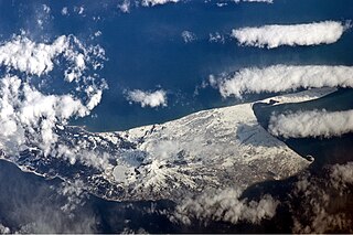
Paramushir is a volcanic island in the northern portion of the Kuril Islands chain in the Sea of Okhotsk in the northwest Pacific Ocean. It is separated from Shumshu by the very narrow Second Kuril Strait in the northeast 2.5 km (1.6 mi), from Antsiferov by the Luzhin Strait to the southwest, from Atlasov in the northwest by 20 km (12 mi), and from Onekotan in the south by the 40 km (25 mi) wide Fourth Kuril Strait. Its northern tip is 39 km (24 mi) from Cape Lopatka at the southern tip of the Kamchatka Peninsula. Its name is derived from the Ainu language, from “broad island” or “populous island”. Severo-Kurilsk, the administrative center of the Severo-Kurilsky district, is the only permanently populated settlement on Paramushir island.

Sarychev Peak is an active stratovolcano covering almost the entirety of Matua Island in the Kuril Islands, Russia. It is a young, highly symmetrical stratovolcanic cone. The height of the plume during the 2009 eruption was estimated at 12 to 18 kilometres.

Mount Yōtei is an active stratovolcano located in Shikotsu-Toya National Park, Hokkaidō, Japan. It is also called Yezo Fuji or Ezo Fuji (蝦夷富士), "Ezo" being an old name for the island of Hokkaido, because it resembles Mount Fuji. The mountain is also known as Makkari Nupuri (マッカリヌプリ) and Mount Shiribeshi. It is one of the 100 famous mountains in Japan.

Simushir, meaning Large Island in Ainu, is an uninhabited volcanic island near the center of the Kuril Islands chain in the Sea of Okhotsk in the northwest Pacific Ocean. It was formerly known as Marikan.

Chirip is a volcano located in the central part of Iturup Island, Kuril Islands, Russia. In lies on the Chirip Peninsula and comprises two twin stratovolcanoes, Chirip and Bogdan Hmelnitskiy. The western side is the steepest, sharing a basin, with a small lake with Bogdan Hmelnitskiy. Basin has features that were created during an eruption. Many types of lava found are basalt, and andesite, small amounts of dacite found.
Golovnin is a caldera located in the southern part of Kunashir Island, Kuril Islands, Russia. It is the southernmost volcano of the Kuril Islands.

Mendeleyeva is a stratovolcano located in the southern part of Kunashir Island, Kuril Islands, Russia.

Rasshua is an uninhabited volcanic island near the center of the Kuril Islands chain in the Sea of Okhotsk in the northwest Pacific Ocean, 16 kilometres (9.9 mi) from Ushishir and 30 kilometres (19 mi) southwest of Matua. Its name is derived from the Ainu language for “fur coat”, "Rushu o a" (ルシュ・オ・ア), or "abundant furs", "Rushi o a" (ルシ・オ・ア).
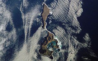
Ushishir is a collective name for two uninhabited volcanic islands and several reefs, all being parts of an eponymous partially submerged volcano, located in the centre of the Kuril Islands chain in the Sea of Okhotsk in the northwest Pacific Ocean. Its name is derived from the Ainu language for "hot spring".
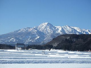
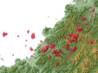
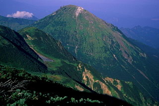
Mount Myōkō is an active stratovolcano in Honshu, Japan. It is situated at the southwest of Myōkō city, Niigata Prefecture, and a part of Jōshin'etsu-kōgen National Park. Mount Myōkō is listed as one of 100 Famous Japanese Mountains, and together with Mount Yahiko, it is well known as the "famous mountain" of Niigata Prefecture.
Abu is the name of a group of shield volcanoes located on the coast of Japan on the southwest end of the island of Honshū. It is primarily based in the city of Hagi, Yamaguchi Prefecture.

Mount Adatara is a stratovolcano in Fukushima Prefecture, Japan.
Mount Maru is a lava dome located in the Nipesotsu-Maruyama Volcanic Group of the Ishikari Mountains, Hokkaidō, Japan. Mount Maru is also known as Higashi-Tokachi-Maruyama (東十勝丸山) or Higashi-Taisetsu-Maruyama (東大雪丸山) to distinguish it from other mountains with the same name. Only in 1989 did scientists discover that Mount Maru is a quaternary volcano. The mountain sits on the border between the towns of Kamishihoro and Shintoku.

Akan Volcanic Complex is a volcanic group of volcanoes that grew out of the Akan caldera. It is located within Akan National Park, about 50 km Northwest of Kushiro in eastern Hokkaidō, Japan.

Mount Norikura is a potentially active volcano located on the borders of Gifu and Nagano prefectures in Japan. It is part of the Hida Mountains and is listed among the 100 Famous Japanese Mountains and the New 100 Famous Japanese Mountains.

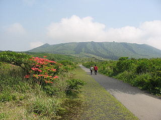
Kirishima Mountains are a 1700 meter high active volcano group in Kagoshima Prefecture and Miyazaki Prefecture, Kyushu, Japan. Numerous eruptions have been recorded since 742. Very strong eruptions happened in 788, 1716 and 1717. Augite-hypersthene andesite is the dominant rock type.
Niigata-Yake-Yama is an active volcano in Honshu, Japan. A large eruption in 887 AD sent pyroclastic flows all the way to the Japan Sea.
