
The Tri-Cities are three closely linked cities at the confluence of the Yakima, Snake, and Columbia Rivers in the Columbia Basin of Eastern Washington. The cities border one another, making the Tri-Cities seem like one uninterrupted mid-sized city. The three cities function as the center of the Tri-Cities metropolitan area, which consists of Benton and Franklin counties. The Tri-Cities urban area consists of the city of West Richland, the census-designated places (CDP) of West Pasco, Washington and Finley, as well as the CDP of Burbank, despite the latter being located in Walla Walla County.

Richland is a city in Benton County, Washington, United States. It is located in southeastern Washington at the confluence of the Yakima and the Columbia Rivers. As of the 2020 census, the city's population was 60,560. Along with the nearby cities of Pasco and Kennewick, Richland is one of the Tri-Cities, and is home to the Hanford nuclear site.
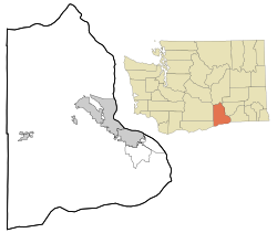
Benton County is a county in the south-central portion of the U.S. state of Washington. As of the 2020 census, its population was 206,873. The county seat is Prosser, and its largest city is Kennewick. The Columbia River demarcates the county's north, south, and east boundaries.

Grant County is a county located in the U.S. state of Washington. As of the 2020 census, the population was 99,123. The county seat is Ephrata, and the largest city is Moses Lake. The county was formed out of Douglas County in February 1909 and is named for U.S. President Ulysses S. Grant.
Kennewick is a city in Benton County in the U.S. state of Washington. It is located along the southwest bank of the Columbia River, just southeast of the confluence of the Columbia and Yakima rivers and across from the confluence of the Columbia and Snake rivers. It is the most populous of the three cities collectively referred to as the Tri-Cities. The United States Census Bureau estimated the population to be 84,750 as of 2022, up from 83,921 at the 2020 United States Census.
Warren County is a county in the U.S. state of Indiana. It lies in the western part of the state between the Illinois state line and the Wabash River. According to the 2020 census, it had a population of 8,440. Its county seat is Williamsport.

Kiowa County is a county located in the U.S. state of Colorado. As of the 2020 census, the population was 1,446, making it the fifth-least populous county in Colorado. The county seat is Eads. The county was named for the Kiowa Nation of Native Americans.
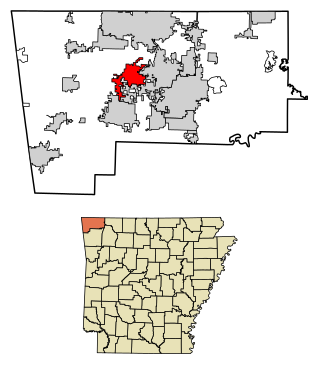
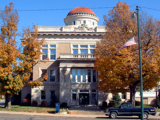
Centerton is a city in Benton County, Arkansas, United States. Located west of Bentonville on Highway 102, Centerton has grown from a railroad stop and fruit orchard community in the early 20th century into a suburban bedroom community within the rapidly growing Northwest Arkansas (NWA) region. The city's population has grown from 491 in 1990 to 16,244 in 2019. Centerton is considered to be one of the fastest growing cities in Arkansas and consistently ranks amongst the safest cities in the state.
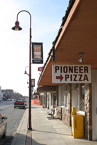
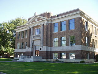
Gentry is a city in Benton County, Arkansas, United States. The population was 3,790 as of the 2020 census. The city was founded in the Ozark Mountains in 1894 along what would become the Kansas City Southern Railroad. The city's prior prosperity in the orchard industry, especially apples, was further strengthened by the rail connection. Following the decline of the apple industry in the 1930s, Gentry shifted its economy towards poultry along with many other areas of Northwest Arkansas.

Hanford is the most populous city and the county seat of Kings County, California, located in the San Joaquin Valley region of the greater Central Valley. The population was 53,967 at the 2010 census.
Otterbein is a town in Shelby Township, Tippecanoe County and Bolivar Township, Benton County, Indiana, named for William Otterbein Brown who donated land for the town. As of the 2010 census, its population was 1,262.
Prosser is a city in and the county seat of Benton County, Washington, United States. Situated along the Yakima River, it had a population of 6,062 at the 2020 census.

Pasco is a city in, and the county seat of, Franklin County, Washington, United States. The population was 77,108 at the 2020 census, and 79,315 as of the July 1, 2022 estimate.

White Bluffs was an agricultural town in Benton County, Washington, United States. It was depopulated in 1943 along with the town of Hanford to make room for the nuclear production facility known as the Hanford Site.

Oldtown is an unincorporated community and census-designated place (CDP) in Allegany County, Maryland, United States, along the North Branch Potomac River. As of the 2010 census, it had a population of 86.
Benton is a census-designated place and unincorporated community in Yazoo County, Mississippi. It was first named as a CDP in the 2020 Census which listed a population of 415.

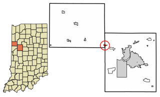
Atkinson is an unincorporated community in Center Township, Benton County, in the U.S. state of Indiana. The site of Atkinson is home to the county's only junior/senior high school, Benton Central.

Camp Columbia or Columbia Camp was a prison labor camp established on the north shore of the Yakima River opening on February 1, 1944 near Horn Rapids. The camp was operated between February 1944 and October 1947 by Federal Bureau of Prisons to provide labor supporting the Hanford Site. The camp was used to house "minimum-custody-type improvable male offenders," who had no more than one year to serve. These were violators of national defense, wartime and military laws. Included were conscientious objectors, violators of rationing and price support laws, those convicted of espionage, sabotage and sedition and those convicted by military courts martial. Aliens who failed to register were also in this category but none of them were sent here because the camp was located on the southern edge of the 670 square miles (1,740 km2) Hanford Site.
Longview is an unincorporated historic community in Benton County, Washington, United States, located approximately three miles west of Umatilla, Oregon on the north bank of the Columbia River, just above Devil's Bend Rapids.

Wahluke Slope is a geographic feature in Grant, Benton and Adams Counties of Eastern Washington. It is a broad, south-facing slope with a grade of about 8%, situated between the Saddle Mountains and the Columbia River's Hanford Reach. It has been described as "basically a 13-mile-wide gravel bar" created by the Glacial Lake Missoula floods at the end of the last ice age about 15,000 years ago. Much of the Slope, part of the Hanford Nuclear Reservation, was added to the Saddle Mountain National Wildlife Refuge in 1999. Much of the remainder is used for viniculture.

 Service station in Hanford, 1930
 Hanford High School, 1925
 Hanford High School, following its use for military training


