Hanover, New Hampshire

Last updated

Hanover, New Hampshire
HanoverNHMainStreet.jpg
Hanover Main Street
Hanover, New Hampshire
Interactive map outlining Hanover
Grafton-Hanover-NH.png
Usa edcp location map.svg
Red pog.svg
Hanover, New Hampshire
Location in the United States
Coordinates: 43°42′08″N72°17′22″W / 43.70222°N 72.28944°W / 43.70222; -72.28944
Country United States
State New Hampshire
County Grafton
Incorporated 1761
Villages
Government
   Selectboard
  • Athos Rassias
  • Joanna Whitcomb
  • Nancy Carter
  • Carey Callaghan
  • Jennie Chamberlain
  Town ManagerAlex Torpey
Area
[1]
  Total50.2 sq mi (129.9 km2)
  Land49.0 sq mi (127.0 km2)
  Water1.1 sq mi (2.9 km2)  2.21%
Elevation
528 ft (161 m)
Population
 (2020) [2]
  Total11,870
  Density242/sq mi (93.5/km2)
Time zone UTC−5 (Eastern)
  Summer (DST) UTC−4 (Eastern)
ZIP codes
03755 (Hanover)
03750 (Etna)
03748 (Enfield)
Area code 603
FIPS code 33-33860
GNIS feature ID0873619
Website www.hanovernh.org

Hanover is a town located along the Connecticut River in Grafton County, New Hampshire, United States. As of the 2020 census, its population was 11,870. [2] The town is home to the Ivy League university Dartmouth College, the U.S. Army Corps of Engineers Cold Regions Research and Engineering Laboratory, and Hanover High School. The Appalachian Trail crosses the town, connecting with a number of trails and nature preserves.

Contents

Most of the population resides in the Hanover census-designated place (CDP)—the main village of the town. Located at the junctions of New Hampshire routes 10, 10A, and 120, the Hanover CDP recorded a population of 9,078 people at the 2020 census. [3] The town also contains the smaller villages of Etna and Hanover Center.

History

Hanover was chartered by Governor Benning Wentworth on July 4, 1761, and in 1765–1766 its first European inhabitants arrived, the majority from Connecticut. Although the surface is uneven, the town developed into an agricultural community. Dartmouth College was established in 1769 beside the town common at a village called "the Plain"—an extensive and level tract of land a mile (1.6 kilometers) from the Connecticut River, and about 150 feet (46 m) above it. [4] [5] [6]

At one point in its history, the southwest corner of Hanover, site of "The Plain", was known as "Dresden", which in the 1780s joined other disgruntled New Hampshire towns along the Connecticut River that briefly defected to what was then the independent Vermont Republic. [7] After various political posturings, however, the towns returned to New Hampshire at the heated insistence of George Washington. [8] One remnant of this era is that the name "Dresden" is still used in the Dresden School District, an interstate school district serving both Hanover and Norwich, Vermont—the first and one of the few interstate school districts in the nation.

The film Winter Carnival (1939) was shot in Hanover. [9]

Etymology

"Hannover" (with a double n, as it was spelled in the 1761 charter and in its German original form as well) was named either after a local parish in Sprague, Connecticut, or after the German House of Hanover (which originated in 1635 as a cadet branch of the House of Brunswick-Lüneburg when George, Duke of Brunswick moved to the city of Hannover) [10] :25 in honor of the reigning British-Hanoverian king, George III. [11] Today, the original Hannover is the capital and largest city of Lower Saxony, the second-largest state in Germany. The name of the German city is thought to derive from the Low German form of what is "hohes Ufer" in German, which translates into "high shore" in English, and describes the high shore of the Leine river at the site, and at the time, of the first known settlement (near today's street At the High Shore  [ de ]).

While it is likely that the name "Dresden" derived from Dresden in Germany, it has also been suggested that it could derive directly from the old Sorbian word drezg ("forest") or Drezd'ane, for an inhabitant of a forest. [12] [13]

Geography

According to the United States Census Bureau, the town has a total area of 50.2 square miles (129.9 km2), of which 49.0 square miles (127.0 km2) are land and 1.1 square miles (2.9 km2) are water, comprising 2.21% of the town. [1] The primary settlement in Hanover, where over 75% of the town's population resides, is in the southwestern corner of the town and is defined as the Hanover census-designated place (CDP). It contains the areas around Dartmouth College and the intersections of New Hampshire Routes 10, 10A, and 120. The CDP has a total area of 5.0 square miles (13 km2), of which 4.6 square miles (12 km2) are land and 0.4 square miles (1.0 km2) are water. [14]

Hanover borders the towns of Lyme, Canaan, and Enfield, New Hampshire; Norwich, Vermont; and the city of Lebanon, New Hampshire. Inside the limits of Hanover are the small rural villages of Etna and Hanover Center.

The highest point in Hanover is the north peak of Moose Mountain, at 2,313 feet (705 m) above sea level. Hanover lies fully within the Connecticut River watershed. [15]

There are a number of trails and nature preserves in Hanover, and the majority of these trails are suitable for snowshoes and cross-country skis. The Velvet Rocks Trail, located on the Appalachian Trail, has a number of rock climbing and bouldering spots. [16]

Climate

According to the Köppen Climate Classification system, Hanover has a warm-summer humid continental climate, abbreviated "Dfb" on climate maps. The hottest temperature recorded in Hanover was 103 °F (39.4 °C) on August 2, 1975, while the coldest temperature recorded was −40 °F (−40.0 °C) on February 16, 1943. [17]

Climate data for Hanover, New Hampshire, 1991–2020 normals, extremes 1893–present
MonthJanFebMarAprMayJunJulAugSepOctNovDecYear
Record high °F (°C)64
(18)
66
(19)
86
(30)
93
(34)
96
(36)
98
(37)
101
(38)
103
(39)
97
(36)
87
(31)
79
(26)
76
(24)
103
(39)
Mean maximum °F (°C)49.4
(9.7)
52.4
(11.3)
62.5
(16.9)
79.5
(26.4)
87.6
(30.9)
91.4
(33.0)
92.3
(33.5)
90.4
(32.4)
87.0
(30.6)
76.5
(24.7)
65.6
(18.7)
52.4
(11.3)
94.2
(34.6)
Mean daily maximum °F (°C)30.3
(−0.9)
34.3
(1.3)
43.7
(6.5)
58.1
(14.5)
70.9
(21.6)
78.8
(26.0)
83.4
(28.6)
81.6
(27.6)
73.8
(23.2)
60.2
(15.7)
47.2
(8.4)
35.6
(2.0)
58.2
(14.5)
Daily mean °F (°C)21.6
(−5.8)
24.3
(−4.3)
33.6
(0.9)
46.5
(8.1)
58.5
(14.7)
67.1
(19.5)
72.1
(22.3)
70.5
(21.4)
62.9
(17.2)
50.2
(10.1)
38.9
(3.8)
28.0
(−2.2)
47.8
(8.8)
Mean daily minimum °F (°C)13.0
(−10.6)
14.4
(−9.8)
23.6
(−4.7)
34.8
(1.6)
46.2
(7.9)
55.4
(13.0)
60.9
(16.1)
59.3
(15.2)
52.1
(11.2)
40.2
(4.6)
30.7
(−0.7)
20.4
(−6.4)
37.6
(3.1)
Mean minimum °F (°C)−11.8
(−24.3)
−9.0
(−22.8)
0.1
(−17.7)
21.0
(−6.1)
30.8
(−0.7)
41.7
(5.4)
49.4
(9.7)
47.5
(8.6)
36.2
(2.3)
25.3
(−3.7)
13.9
(−10.1)
−1.6
(−18.7)
−15.3
(−26.3)
Record low °F (°C)−34
(−37)
−40
(−40)
−22
(−30)
0
(−18)
20
(−7)
29
(−2)
38
(3)
33
(1)
22
(−6)
11
(−12)
−12
(−24)
−37
(−38)
−40
(−40)
Average precipitation inches (mm)2.73
(69)
2.38
(60)
2.96
(75)
3.24
(82)
3.34
(85)
3.70
(94)
4.48
(114)
3.55
(90)
3.33
(85)
4.00
(102)
3.00
(76)
3.44
(87)
40.15
(1,019)
Average snowfall inches (cm)16.4
(42)
13.1
(33)
13.5
(34)
1.9
(4.8)
0.0
(0.0)
0.0
(0.0)
0.0
(0.0)
0.0
(0.0)
0.0
(0.0)
0.1
(0.25)
2.2
(5.6)
13.4
(34)
60.6
(153.65)
Average extreme snow depth inches (cm)12.0
(30)
15.3
(39)
13.2
(34)
3.3
(8.4)
0.0
(0.0)
0.0
(0.0)
0.0
(0.0)
0.0
(0.0)
0.0
(0.0)
0.2
(0.51)
1.6
(4.1)
8.3
(21)
17.8
(45)
Average precipitation days (≥ 0.01 in)10.88.99.710.711.712.112.610.711.312.210.210.7131.6
Average snowy days (≥ 0.1 in)8.36.54.01.10.00.00.00.00.00.11.66.127.7
Source 1: NOAA [18]
Source 2: National Weather Service [17]

Demographics

Historical population
CensusPop.Note
1790 1,380
1800 1,91238.6%
1810 2,13511.7%
1820 2,2224.1%
1830 2,3616.3%
1840 2,61310.7%
1850 2,350−10.1%
1860 2,308−1.8%
1870 2,085−9.7%
1880 2,1473.0%
1890 1,817−15.4%
1900 1,8843.7%
1910 2,07510.1%
1920 2,2649.1%
1930 3,04334.4%
1940 3,42512.6%
1950 6,25982.7%
1960 7,32917.1%
1970 8,49415.9%
1980 9,1197.4%
1990 9,2121.0%
2000 10,85017.8%
2010 11,2603.8%
2020 11,8705.4%
U.S. Decennial Census [2] [19]

As of the census of 2010, there were 11,260 people, 3,119 households, and 1,797 families residing in the town. The population density was 220 people per square mile (85 people/km2). There were 3,278 housing units at an average density of 65.2 per square mile (25.2/km2). The racial makeup of the town was 81.0% White, 3.4% Black, 0.8% Native American, 10.8% Asian, 0.03% Pacific Islander, 0.7% from other races, and 3.2% from two or more races. Hispanic or Latino of any race were 3.9% of the population. [20]

There were 3,119 households, out of which 27.4% had children under the age of 18 living with them, 51.5% were married couples living together, 4.7% had a female householder with no husband present, and 42.4% were non-families. 31.0% of all households were made up of individuals, and 16.1% had someone living alone who was 65 years of age or older. The average household size was 2.37 and the average family size was 2.95. [20]

In the town, the population was spread out, with 27.8% at or under the age of 19, 25.5% from 20 to 24, 14.4% from 25 to 44, 18.6% from 45 to 64, and 13.7% who were 65 years of age or older. The median age was 23 years. [20]

For the period 2010–2014, the estimated median income for a household in the town was $94,063, and the median income for a family was $129,000. Male full-time workers had a median income of $87,550 versus $53,141 for females. The per capita income for the town was $34,140. About 2.0% of families and 12.0% of the population were below the poverty line, including 3.4% of those under age 18 and 4.8% of those age 65 or over. [21]

Government

Hanover town vote
by party in presidential elections
[22]
Year GOP DEM Others
2020 11.8% 84187.3%6,2100.93% 66
2016 11.94% 92684.63%6,5613.43% 266
2012 23.67% 1,72774.97%5,4691.36% 99
2008 17.67% 1,32881.69%6,1400.64% 48
2004 21.70% 1,44477.42%5,1520.89% 59
2000 29.56% 1,54165.05%3,3915.39% 281
1996 31.71% 1,42463.16%2,8365.12% 230
1992 25.91% 1,20162.70%2,90611.39% 528
1988 [23] 40.33% 1,47258.96%2,1520.71% 26
1984 [24] 44.17% 1,50155.50%1,8860.33% 11
1980 [25] 33.15% 1,10834.20%1,14332.65% 1,091
1976 [26] 46.17% 1,48350.25%1,6143.58% 115
1972 [27] 39.88% 1,37759.75%2,0630.38% 13

In the New Hampshire Senate, Hanover is included in the 5th District and is represented by Democrat Suzanne Prentiss. On the New Hampshire Executive Council, Hanover is in the 1st District and is represented by Republican Joseph Kenney. In the United States House of Representatives, Hanover is a part of New Hampshire's 2nd congressional district and is currently represented by Democrat Ann McLane Kuster.

No Republican presidential nominee has received over 40 percent of the vote in the town since 1988.

Education

Students playing cricket at Dartmouth College in 1793 A Front View of Dartmouth College (1793).jpg
Students playing cricket at Dartmouth College in 1793
Public schools
Universities
Private schools

Economy

Ledyard National Bank on Main Street Ledyard National Bank Main Street downtown Hanover NH May 2021.jpg
Ledyard National Bank on Main Street

Hypertherm, [29] White Mountains Insurance Group, and Daat Research Corp. are based in Hanover.

Infrastructure

Water

The Hanover Water Company supplies water for downtown Hanover from several local reservoirs. The company is owned by Dartmouth College (52.8%) and the Town of Hanover (47.2%), with management by the Town of Hanover under a contract. In 2000, all full-time company employees became town employees. In recent years, the town has spent over $20 million to upgrade main water lines, and will undergo another $6 million project to build a new water treatment plant. Outside the downtown area, residents rely on private wells that are not maintained by the town.

Other utilities

FairPoint Communications furnishes telephone communication. The municipality provides sewage treatment.

Plaudits

CNN and Money magazine rated Hanover the sixth best place to live in America in 2011, [30] and the second best in 2007. [31] "This just might be the best college town," read the headline of a story in the January–February 2017 issue of Yankee . [32]

Notable people

Related Research Articles

<span class="mw-page-title-main">Norwich, Vermont</span> Town in Vermont, United States

Norwich is a town in Windsor County, Vermont, United States. The population was 3,612 at the 2020 census. Home to some of the state of Vermont's wealthiest residents, the municipality is a commuter town for nearby Hanover, New Hampshire across the Connecticut River. The town is part of the Dresden School District, the first interstate school district in the United States, signed into law by President John F. Kennedy. The town contains the Norwich Mid-Century Modern Historic District.

<span class="mw-page-title-main">Grafton County, New Hampshire</span> County in New Hampshire, United States

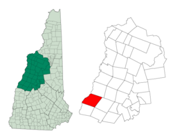
Grafton County is a county in the U.S. state of New Hampshire. As of the 2020 census, the population was 91,118. Its county seat is the town of Haverhill. In 1972, the county courthouse and other offices were moved from Woodsville, a larger village within the town of Haverhill, to North Haverhill.

<span class="mw-page-title-main">Bath, New Hampshire</span> Town in New Hampshire, United States

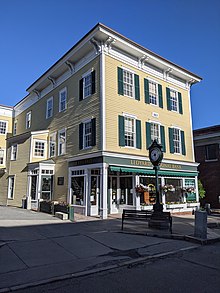
Bath is a town in Grafton County, New Hampshire, United States. The population was 1,077 at the 2020 census, unchanged from the 2010 census. Now a tourist destination and commuter town for Littleton, the town is noted for its historic architecture, including the Brick Store and three covered bridges. Bath includes the village of Swiftwater and part of the district known as Mountain Lakes.

<span class="mw-page-title-main">Benton, New Hampshire</span> Town in New Hampshire, United States

Benton is a town in Grafton County, New Hampshire, United States. The population was 374 at the 2020 census. Located in the White Mountains, Benton is largely surrounded by the White Mountain National Forest. The town is crossed by the Appalachian Trail.

<span class="mw-page-title-main">Bethlehem, New Hampshire</span> Town in New Hampshire, United States

Bethlehem is a hillside town in Grafton County, New Hampshire, United States. The population was 2,484 at the 2020 census. It is home to Cushman and Strawberry Hill state forests. The eastern half of the town is within the White Mountain National Forest. The Appalachian Trail crosses a small portion of the town in the south.

<span class="mw-page-title-main">Canaan, New Hampshire</span> Town in New Hampshire, United States

Canaan is a town in Grafton County, New Hampshire, United States. The population was 3,794 at the 2020 census. It is the location of Mascoma State Forest. Canaan is home to the Cardigan Mountain School, the town's largest employer.

<span class="mw-page-title-main">Landaff, New Hampshire</span> Town in New Hampshire, United States

Landaff is a town in Grafton County, New Hampshire, United States. As of the 2020 census, the town population was 446.

<span class="mw-page-title-main">Lebanon, New Hampshire</span> City in New Hampshire, United States

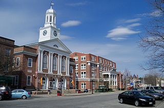
Lebanon is the only city in Grafton County, New Hampshire, United States. The population was 14,282 at the 2020 census, up from 13,151 at the 2010 census. Lebanon is in western New Hampshire, south of Hanover, near the Connecticut River. It is the home to Dartmouth–Hitchcock Medical Center and Dartmouth College's Geisel School of Medicine, together comprising the largest medical facility between Boston, Massachusetts, and Burlington, Vermont.

<span class="mw-page-title-main">Lyme, New Hampshire</span> Town in New Hampshire, United States

Lyme is a town along the Connecticut River in Grafton County, New Hampshire, United States. The population was 1,745 as of the 2020 census. Lyme is home to the Chaffee Natural Conservation Area. The Dartmouth Skiway is in the eastern part of town, near the village of Lyme Center. The Appalachian Trail passes through the town's heavily wooded eastern end.

<span class="mw-page-title-main">Orford, New Hampshire</span> Town in New Hampshire, United States

Orford is a town in Grafton County, New Hampshire, United States. The population was 1,237 at the 2020 census, unchanged from the 2010 census. The Appalachian Trail crosses in the east.

<span class="mw-page-title-main">Piermont, New Hampshire</span> Town in New Hampshire, United States

Piermont is a town in Grafton County, New Hampshire, United States. The population was 769 at the 2020 census. It is home to Camp Walt Whitman and Kingswood Camp for Boys.

<span class="mw-page-title-main">Warren, New Hampshire</span> Town in New Hampshire, United States

Warren is a town in Grafton County, New Hampshire, United States. The population was 825 at the 2020 census, down from 904 at the 2010 census. Warren includes the village of Glencliff. The Appalachian Trail crosses the town in the west.

<span class="mw-page-title-main">Woodsville, New Hampshire</span> Census-designated place in New Hampshire, United States

Woodsville is a census-designated place (CDP) and the largest village in the town of Haverhill in Grafton County, New Hampshire, United States, along the Connecticut River at the mouth of the Ammonoosuc River. The population was 1,431 at the 2020 census. Although North Haverhill is now the county seat of Grafton County, the village of Woodsville has traditionally been considered the county seat, as the county courthouse was originally located there. The county buildings are now located halfway between Woodsville and the village of North Haverhill to the south.

Hanover is a census-designated place (CDP) and the main village in the town of Hanover in Grafton County, New Hampshire, United States. The population of the CDP was 9,078 at the 2020 census, out of 11,870 in the entire town. The CDP includes the campus of Dartmouth College.

Lisbon is a census-designated place (CDP) and the main village in the town of Lisbon in Grafton County, New Hampshire, United States. The population of the CDP was 965 at the 2020 census, out of 1,621 in the entire town.

Littleton is a census-designated place (CDP) and the main village in the town of Littleton in Grafton County, New Hampshire, United States. The population of the CDP was 4,467 at the 2020 census, out of 6,005 in the entire town.

<span class="mw-page-title-main">Littleton, New Hampshire</span> Town in New Hampshire, United States

Littleton is a town in Grafton County, New Hampshire, United States. The population was 6,005 at the 2020 census. Situated at the northern edge of the White Mountains, Littleton is bounded on the northwest by the Connecticut River.

<span class="mw-page-title-main">Plymouth, New Hampshire</span> Town in New Hampshire, United States

Plymouth is a rural town in Grafton County, New Hampshire, United States, in the White Mountains Region. It has a unique role as the economic, medical, commercial, and cultural center for the predominantly rural Plymouth, NH Labor Market Area. Plymouth is located at the confluence of the Pemigewasset and Baker rivers and sits at the foot of the White Mountains. The town's population was 6,682 at the 2020 census. It is home to Plymouth State University, Speare Memorial Hospital, and Plymouth Regional High School.

<span class="mw-page-title-main">North Woodstock, New Hampshire</span> Census-designated place in New Hampshire, United States

North Woodstock is a census-designated place (CDP) and the primary village in the town of Woodstock in Grafton County, New Hampshire, United States. It had a population of 739 at the 2020 census.

<span class="mw-page-title-main">Ashland (CDP), New Hampshire</span> Census-designated place in New Hampshire, United States

Ashland is a census-designated place (CDP) and the main village in the town of Ashland in Grafton County, New Hampshire, United States. The population of the CDP was 1,082 at the 2020 census, out of 1,938 in the entire town.

References

  1. 1 2 "2021 U.S. Gazetteer Files – New Hampshire". United States Census Bureau. Retrieved November 29, 2021.
  2. 1 2 3 "Hanover town, Grafton County, New Hampshire: 2020 DEC Redistricting Data (PL 94-171)". U.S. Census Bureau. Retrieved November 29, 2021.
  3. "Hanover CDP, New Hampshire: 2020 DEC Redistricting Data (PL 94-171)". U.S. Census Bureau. Retrieved November 29, 2021.
  4. Coolidge, Austin J.; John B. Mansfield (1859). A History and Description of New England. Boston, Massachusetts: A.J. Coolidge. pp.  516–519.
  5. "A history of the town of Hanover, N.H. | WorldCat.org". www.worldcat.org. Retrieved November 17, 2022.
  6. Lord, John King (1928). A history of the town of Hanover, N.H. Allen County Public Library Genealogy Center. [Hanover] Printed for the town of Hanover by the Dartmouth Press.
  7. Hill, Ralph Nading (1965). Hill, Ralph Nading (ed.). The College on the Hill: A Dartmouth Chronicle. Hanover, NH: Dartmouth Publishing. p. 46. doi:10.1349/ddlp.1484.
  8. Daniell, Jere (1976). "The American Republic: 1760–1780: The Western Rebellion". New Hampshire Profile. The Flow of History. Archived from the original on November 22, 2010. Retrieved February 8, 2011.
  9. Barth, Jack (1991). Roadside Hollywood: The Movie Lover's State-By-State Guide to Film Locations, Celebrity Hangouts, Celluloid Tourist Attractions, and More. Contemporary Books. Page 249. ISBN   9780809243266.
  10. Mlynek, Klaus; Röhrbein, Waldemar R. (eds.). "Chronik der Stadt Hannover von den Anfängen bis 1988 – Tabellarische Darstellung" [History of the City of Hannover from the Beginnings to 1988 – Tabulated Layout](PDF). Stadtchronik Hannover[History of the City of Hannover] (in German). Stadtarchiv Hannover. Retrieved June 20, 2023.
  11. "About the Town of Hanover". www.hanovernh.org. Archived from the original on May 28, 2010. Retrieved February 8, 2011.
  12. The settlers in the riverside forest, an appellation fully compatible with that of the early inhabitants of the Hanover Plain.
  13. Dick Hoefnagel and Virginia L. Close. "Dresden: What Is in the Name" . Retrieved October 25, 2008.
  14. "Geographic Identifiers: 2010 Census Summary File 1 (G001), Hanover CDP, New Hampshire". American FactFinder. U.S. Census Bureau. Archived from the original on February 13, 2020. Retrieved June 22, 2016.
  15. Foster, Debra H.; Batorfalvy, Tatianna N.; Medalie, Laura (1995). Water Use in New Hampshire: An Activities Guide for Teachers. U.S. Department of the Interior and U.S. Geological Survey.
  16. "Climbing in Black Velvet Canyon Boulders, Red Rock". Mountain Project. Retrieved December 23, 2019.
  17. 1 2 "NOAA Online Weather Data – NWS Gray/Portland". National Weather Service. Retrieved February 5, 2023.
  18. "U.S. Climate Normals Quick Access – Station: Hanover, NH". National Oceanic and Atmospheric Administration. Retrieved February 5, 2023.
  19. "Census of Population and Housing". Census.gov. Retrieved June 4, 2016.
  20. 1 2 3 "Profile of General Population and Housing Characteristics: 2010 Census Summary File 1 (DP-1), Hanover town, Grafton County, New Hampshire". American FactFinder. U.S. Census Bureau. Archived from the original on February 13, 2020. Retrieved June 22, 2016.
  21. "Selected Economic Characteristics: 2010-2014 American Community Survey 5-Year Estimates (DP03), Hanover town, Grafton County, New Hampshire". American FactFinder. U.S. Census Bureau. Archived from the original on February 13, 2020. Retrieved June 22, 2016.
  22. "State Election Results - NHSOS".
  23. "Manual for the General Court". 1989.
  24. "Manual for the General Court". 1985.
  25. "Manual for the General Court". 1981.
  26. "Manual for the General Court". 1977.
  27. "Manual for the General Court". 1973.
  28. Hopkins, Robert C.; Rearick, Richard R. (1995). Cardigan Mountain School: History, 1945-1995. Littleton, NH: Sherwin Dodge. pp. 81–88.
  29. Hypertherm
  30. "Best Places to Live: Top 100 - Hanover, N.H. (6)". Money Magazine. Cable News Network. A Time Warner Company. Retrieved November 1, 2011.
  31. "Best Places to Live: Top 100 - Hanover, N.H. (2)". Money Magazine. Cable News Network. A Time Warner Company. Retrieved February 8, 2011.
  32. "Hanover, New Hampshire | Could You Live Here? - New England Today". New England Today. December 17, 2016. Retrieved February 21, 2017.