The Second Avenue Subway is a New York City Subway line that runs under Second Avenue on the East Side of Manhattan. The first phase of this new line, with three new stations on Manhattan's Upper East Side, opened on January 1, 2017. The full Second Avenue Line, if and when it will be funded, will be built in three more phases to eventually connect Harlem–125th Street in Harlem to Hanover Square in Lower Manhattan. The proposed full line would be 8.5 miles (13.7 km) and 16 stations long, serve a projected 560,000 daily riders, and cost more than $17 billion.
The Westchester Square–East Tremont Avenue station is a local station on the IRT Pelham Line of the New York City Subway. Located at the intersection of East Tremont and Westchester Avenues in Westchester Square, Bronx, it is served by the 6 train at all times except weekdays in the peak direction, when the <6> train takes over.

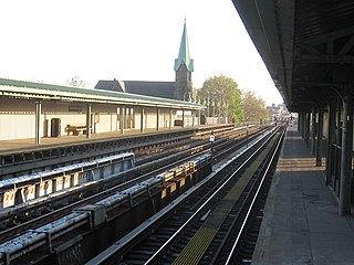
The West Farms Square–East Tremont Avenue station is a local station on the IRT White Plains Road Line of the New York City Subway. Located at the intersection of East Tremont Avenue and Boston Road in the West Farms neighborhood of the Bronx, it is served by the 2 train at all times, and the 5 train at all times except late nights and rush hours in the peak direction.
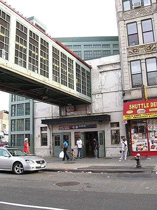
The Franklin Avenue station is a station complex shared by the BMT Franklin Avenue Line and the IND Fulton Street Line of the New York City Subway, located at Franklin Avenue and Fulton Street in Bedford–Stuyvesant, Brooklyn. It is served by the:
The BMT Canarsie Line is a rapid transit line of the B Division of the New York City Subway system, named after its terminus in the Canarsie neighborhood of Brooklyn. It is served by the L train at all times, which is shown in medium gray on the New York City Subway map and on station signs.

The New York City Subway is a rapid transit system that serves four of the five boroughs of New York City, New York: the Bronx, Brooklyn, Manhattan, and Queens. Its operator is the New York City Transit Authority (NYCTA), which is controlled by the Metropolitan Transportation Authority (MTA) of New York. In 2016, an average of 5.66 million passengers used the system daily, making it the busiest rapid transit system in the United States and the seventh busiest in the world.

The IRT Third Avenue Line, commonly known as the Third Avenue Elevated, Third Avenue El, or Bronx El, was an elevated railway in Manhattan and the Bronx, New York City. Originally operated by the New York Elevated Railway, an independent railway company, it was acquired by the Interborough Rapid Transit Company (IRT) and eventually became part of the New York City Subway system.
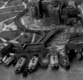
The South Ferry station was an elevated station at the southern terminal of the IRT Second, Third, Sixth and Ninth Avenue Lines. It was located next to Battery Park at the lower tip of Manhattan, New York City. Two tracks came from the combined Second and Third Avenue Lines, and two from the Sixth and Ninth Avenue Lines, making four tracks at the terminal, with platforms on the outside and between each pair of tracks.
The IRT Pelham Line is a rapid transit line on the New York City Subway, operated as part of the A Division and served by the 6 and <6> trains. It was built as part of the Dual Contracts expansion and opened between 1918 and 1920. It is both elevated and underground with Whitlock Avenue being the southernmost elevated station. It has three tracks from the beginning to just south of the Pelham Bay Park terminal. The Pelham Line also has a connection to Westchester Yard, where 6 trains are stored, just north of Westchester Square–East Tremont Avenue. As of 2013, it has a daily ridership of 205,590.

The 111th Street station is a station on the IND Fulton Street Line of the New York City Subway, located on Liberty Avenue at 111th Street in Richmond Hill, Queens. The station is served by the A train at all times.

The Court Square–23rd Street station is a New York City Subway station complex on the IND Crosstown Line, the IRT Flushing Line and the IND Queens Boulevard Line. The complex is located in the vicinity of One Court Square in Hunters Point and Long Island City, Queens, and is served by the 7, E, F, and G trains at all times; the <7> express train during weekdays in the peak direction; and the <F> train during rush hours in the reverse-peak direction.
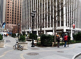
Hanover Square is a square with a public park in the Financial District of Lower Manhattan in New York City. It is triangular in shape, formed by the intersections of Pearl Street and Hanover Street; Pearl Street and a street named "Hanover Square" itself (whose opposite side of Pearl continues as Hanover St.; and William Street and Stone Street. The side between Hanover/Pearl intersection and William/Stone intersection is a pedestrian pathway along the building front facing the square and Pearl Street. Most surrounding buildings are primarily commercial.
The 129th Street station was a transfer station on the IRT Third Avenue Line in Manhattan, New York City, shared by elevated trains of both the Third Avenue Line and IRT Second Avenue Line. The next stop to the north was 133rd Street for the main line and Willis Avenue for the Willis Avenue spur, both of which were across a swing bridge above the Harlem River in the Bronx. The next stop to the south was 125th Street−Third Avenue for Third Avenue Line trains and 125th Street−Second Avenue for Second Avenue Line trains.

The Franklin Square station was an express station on the demolished IRT Third Avenue Line in Manhattan, New York City. It was built by the New York Elevated Railroad in 1878 over the aforementioned square, had two tracks and one island platform, and was the northernmost station on the line that shared both Second Avenue and Third Avenue trains. The next stop to the north was Chatham Square. The next stop to the south was Fulton Street. The station closed on December 22, 1950.
The Fulton Street station was an express station on the demolished IRT Third Avenue Line in Manhattan, New York City. The station was originally built in 1878 by the New York Elevated Railroad and had two tracks and one island platform. The next stop to the north was Franklin Square. The next stop to the south was Hanover Square. The station closed on December 22, 1950. The site of the former station is located in a playground across from the Titanic Memorial Park.

The 34th Street station was a local station on the demolished IRT Second Avenue Line in Manhattan, New York City. It had two levels. The upper level had three tracks and two side platforms and was used for the Second Avenue line trains. The lower level, also known as the Second Avenue station, had two tracks and one island platform and was used by 34th Street shuttle trains. The next stop to the north was 42nd Street. The next stop to the south was 23rd Street. The next eastbound stop on the shuttle was 34th Street Ferry. The next westbound stop on the shuttle was Third Avenue. The shuttle platform closed on July 14, 1930, and the main line station closed on June 13, 1942.

The City Hall station was a station on the IRT Second Avenue Line in Manhattan, New York City, which also served trains of the IRT Third Avenue Line. It lay along Park Row, south of the Manhattan Municipal Building, across the street from the BRT’s Park Row Terminal. It had 2 levels. The lower level served Third Avenue trains and had two tracks with two side platforms for exiting passengers, and a center island platform for entering passengers. The upper level served Second Avenue trains and had two tracks and two side platforms for exiting passengers, and one island platform for entering passengers. Second Avenue trains served the station until June 13, 1942, and Third Avenue trains served the station until December 31, 1953. The next stop to the north was Chatham Square for all trains.

The Queens Boulevard station was a local station on the demolished section of the BMT Jamaica Line in Queens, New York City. It had two tracks and two side platforms, with space for a third track in the center. This station was built as part of the Dual Contracts. It opened on July 3, 1918, and was closed in 1985 in anticipation of the Archer Avenue Subway, and due to political pressure in the area. The next stop to the north was Sutphin Boulevard, until it was closed in 1977 and Queens Boulevard became a terminal station. The next stop to the south was Metropolitan Avenue.


