Sustained ground vibration associated with underground movement of magma or volcanic gas
Seismograph recording of harmonic tremorFour major types of seismograms, or seismic signatures
A harmonic tremor is a sustained release of seismic and infrasonicenergy typically associated with the underground movement of magma, the venting of volcanic gases from magma, or both. It is a long-duration release of seismic energy, with distinct spectral lines, that often precedes or accompanies a volcanic eruption. More generally, a volcanic tremor is a sustained signal that may or may not possess these harmonic spectral features. Being a long-duration continuous signal from a temporally extended source, a volcanic tremor contrasts distinctly with transient sources of seismic radiation, such as tremors that are typically associated with earthquakes and explosions.
Volcanology is the study of volcanoes, lava, magma and related geological, geophysical and geochemical phenomena (volcanism). The term volcanology is derived from the Latin word vulcan. Vulcan was the ancient Roman god of fire.
Nevado del Ruiz, also known as La Mesa de Herveo is a volcano on the border of the departments of Caldas and Tolima in Colombia, about 129 km (80 mi) west of the capital city Bogotá. It is a stratovolcano composed of many layers of lava alternating with hardened volcanic ash and other pyroclastic rocks. Volcanic activity at Nevado del Ruiz began about two million years ago, since the Early Pleistocene or Late Pliocene, with three major eruptive periods. The current volcanic cone formed during the present eruptive period, which began 150,000 years ago.
Katla is an active volcano in southern Iceland. This particular volcano has been very active historically with at least twenty documented major eruptions since 2920 BC. In its recent history though, Katla has been less active as the last major eruption occurred in 1918. These eruptions have had a Volcanic Explosivity Index (VEI) of between 4 and 5 on a scale of 0 to 8. In comparison, the Eyjafjallajökull 2010 eruption had a VEI of 4. Larger VEI-5 eruptions are comparable to Mount St. Helens 1980 eruption. Several smaller (minor) eruptions measuring VEI-1 and below have occurred since, with the most recent being in 1999.
Grímsvötn is an active volcano with a fissure system located in Vatnajökull National Park, Iceland. The volcano itself is completely subglacial and located under the northwestern side of the Vatnajökull ice cap. The subglacial caldera is at 64°25′N17°20′W, at an elevation of 1,725 m (5,659 ft). Beneath the caldera is the magma chamber of the Grímsvötn volcano.
Redoubt Volcano, or Mount Redoubt, is an active stratovolcano in the largely volcanic Aleutian Range of the U.S. state of Alaska. Located at the head of the Chigmit Mountains subrange in Lake Clark National Park and Preserve, the mountain is just west of Cook Inlet, in the Kenai Peninsula Borough about 110 miles (180 km) southwest of Anchorage. At 10,197 feet (3,108 m), in just over 5 miles (8.0 km) Mount Redoubt attains 9,150 feet (2,790 m) of prominence over its surrounding terrain. It is the highest summit in the Aleutian Range. In 1976, Redoubt Volcano was designated as a National Natural Landmark by the National Park Service.
A volcano tectonic earthquake or volcano earthquake is caused by the movement of magma beneath the surface of the Earth. The movement results in pressure changes where the rock around the magma has experienced stress. At some point, this stress can cause the rock to break or move. This seismic activity is used by scientists to monitor volcanoes. The earthquakes may also be related to dike intrusion or occur as earthquake swarms.
The 2004–2008 volcanic activity of Mount St. Helens in Washington, United States has been documented as a continuous eruption in the form of gradual extrusion of magma. Starting in October 2004 and ceasing in January 2008, a new lava dome was built up. The new dome did not rise above the rim of the crater created by the 1980 eruption of Mount St. Helens.
Prediction of volcanic activity, or volcanic eruption forecasting, is an interdisciplinary monitoring and research effort to predict the time and severity of a volcano's eruption. Of particular importance is the prediction of hazardous eruptions that could lead to catastrophic loss of life, property, and disruption of human activities.
Nazko Cone is a small potentially active basaltic cinder cone in central British Columbia, Canada, located 75 km west of Quesnel and 150 kilometers southwest of Prince George. It is considered the easternmost volcano in the Anahim Volcanic Belt. The small tree-covered cone rises 120 m above the Chilcotin-Nechako Plateau and rests on glacial till. It was formed in three episodes of activity, the first of which took place during the Pleistocene interglacial stage about 340,000 years ago. The second stage produced a large hyaloclastite scoria mound erupted beneath the Cordilleran Ice Sheet during the Pleistocene. Its last eruption produced two small lava flows that traveled 1 km to the west, along with a blanket of volcanic ash that extends several km to the north and east of the cone.
A slow earthquake is a discontinuous, earthquake-like event that releases energy over a period of hours to months, rather than the seconds to minutes characteristic of a typical earthquake. First detected using long term strain measurements, most slow earthquakes now appear to be accompanied by fluid flow and related tremor, which can be detected and approximately located using seismometer data filtered appropriately. That is, they are quiet compared to a regular earthquake, but not "silent" as described in the past.
The Anahim hotspot is a hypothesized hotspot in the Central Interior of British Columbia, Canada. It has been proposed as the candidate source for volcanism in the Anahim Volcanic Belt, a 300 kilometres long chain of volcanoes and other magmatic features that have undergone erosion. This chain extends from the community of Bella Bella in the west to near the small city of Quesnel in the east. While most volcanoes are created by geological activity at tectonic plate boundaries, the Anahim hotspot is located hundreds of kilometres away from the nearest plate boundary.
Episodic tremor and slip (ETS) is a seismological phenomenon observed in some subduction zones that is characterized by non-earthquake seismic rumbling, or tremor, and slow slip along the plate interface. Slow slip events are distinguished from earthquakes by their propagation speed and focus. In slow slip events, there is an apparent reversal of crustal motion, although the fault motion remains consistent with the direction of subduction. ETS events themselves are imperceptible to human beings and do not cause damage.
Bernard A. Chouet is a geophysicist who specializes in volcanic seismology. He discovered that volcanic eruptions could be predicted by observing the frequency of certain seismic waves that are generated by volcanoes.
The 1868 Hawaii earthquake was the largest recorded in the history of Hawaiʻi island, with an estimated magnitude of 7.9 Mfa and a maximum Mercalli intensity of X (Extreme). The earthquake occurred at 4 p.m. local time on April 2, 1868 and caused a landslide and tsunami that led to 77 deaths. The aftershock sequence for this event has continued up to the present day.
A series of small volcanic earthquakes measuring less than 4.0 on the Richter magnitude scale took place in the sparsely populated Nazko area of the Central Interior of British Columbia, Canada, from October 9, 2007, to June 12, 2008. They occurred just west of Nazko Cone, a small tree-covered cinder cone that last erupted about 7,200 years ago.
The following outline is provided as an overview of and topical guide to geophysics:
The 2011–2012 El Hierro eruption occurred just off the island of El Hierro, the smallest and farthest south and west of the Canary Islands, in the Atlantic Ocean off the coast of Africa. The island is also the youngest in the volcanic chain. The October 2011 – March 2012 eruption was underwater, with a fissure of vents located approximately 2 kilometres to the south of the fishing village of La Restinga on the southern coast of the island. Increased seismicity in June 2012 to the north-west of the vent did not result in another phase of eruptive activity. Until the 2021 La Palma eruption, which started on 19 September 2021, this was the last volcanic eruption in Spain.
The 2014–2015 eruption of Bárðarbunga was a Hawaiian eruption in the Bárðarbunga volcanic system in Iceland, that began on August 29, 2014, and ended on February 27, 2015. The eruption emitted large volumes of sulphur dioxide and impacted air quality in Iceland. There was no effect on flights outside of the immediate vicinity due to a lack of a significant emission of volcanic ash. The eruption took place in the lava field of Holuhraun northeast of the Bárðarbunga caldera proper.
As part of the Comoro Islands chain in the Mozambique Channel, the geology of Mayotte is virtually the same as the geology of the Comoros, the rest of the island chain which is independent of France. The island resulted from the rifting of Madagascar away from Africa as well as "hotspot" mantle plume activity, and is also impacted by seismicity and deformation associated with the East African Rift. However, because Mayotte is a part of France its geology is significantly more researched than that of other islands in the chain.
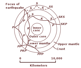
The 11 November 2018 Mayotte seismic event is a seismic event of unknown origin that occurred about 24 kilometres (15 mi) off the coast of Mayotte, an overseas department and region of France in the Indian Ocean. It was recorded by seismograms globally, including in Kenya, Chile, New Zealand, Canada, and Hawaii, almost 18,000 kilometres (11,000 mi) away. Despite this, no one felt it. The seismic waves lasted for over 20 minutes. Most earthquakes have P waves and S waves, which are later followed by long-period surface waves. The Mayotte event lacked P waves and S waves, but did cause a long-period surface wave travelling at 14,000 km/h (9,000 mph) around the globe. Additionally, the signal released by the earthquake resembled a clean sine wave, while most earthquake waves have multiple frequencies.
This page is based on this Wikipedia article Text is available under the CC BY-SA 4.0 license; additional terms may apply. Images, videos and audio are available under their respective licenses.