Related Research Articles
Eritrea is an ancient name, associated in the past with its Greek form Erythraia, Ἐρυθραία, and its derived Latin form Erythræa. This name relates to that of the Red Sea, then called the Erythræan Sea, from the Greek for "red", ἐρυθρός, erythros. But earlier Eritrea was called Mdre Bahri. The Italians created the colony of Eritrea in the 19th century around Asmara and named it with its current name. After World War II, Eritrea annexed to Ethiopia. Following the communist Ethiopian government's defeat in 1991 by the coalition created by various armed groups notably the EPLF and the TPLF among others, Eritrea declared its independence. Eritrea officially celebrated its 1st anniversary of independence on May 24,1994.

The foreign relations of Ethiopia refers to overall diplomatic relationship of Ethiopia. The Ministry of Foreign Affairs oversees foreign relations and diplomatic missions of the country.

Ethiopia, officially the Federal Democratic Republic of Ethiopia, is a landlocked country located in the Horn of Africa region of East Africa. It shares borders with Eritrea to the north, Djibouti to the northeast, Somalia to the east and southeast, Kenya to the south, South Sudan to the west, and Sudan to the northwest. Ethiopia covers a land area of 1,112,000 square kilometres. As of 2023, it is home to around 116.5 million inhabitants, making it the 13th-most populous country in the world, the 2nd-most populous in Africa after Nigeria, and the most populated landlocked country on Earth. The national capital and largest city, Addis Ababa, lies several kilometres west of the East African Rift that splits the country into the African and Somali tectonic plates.

Axum, also spelled Aksum, is a town in the Tigray Region of Ethiopia with a population of 66,900 residents. It is the site of the historic capital of the Aksumite Empire, a naval and trading power that ruled the whole region in addition parts of West Asia as Saudi Arabia, and Yemen. It ruled the region from about 400 BCE into the 10th century. Axum is located at the La’ilay Maychew district of Ethiopia.
Yeha is a town in the Maekelay Zone of the northern Tigray Region in Ethiopia. It likely served as the capital of the pre-Aksumite kingdom of D'mt.

D mt was a kingdom located in Eritrea and northern Ethiopia that existed between the 10th and 5th centuries BC. Few inscriptions by or about this kingdom survive and very little archaeological work has taken place. As a result, it is not known whether Dʿmt ended as a civilization before the Kingdom of Aksum's early stages, evolved into the Aksumite state, or was one of the smaller states united in the Kingdom of Aksum possibly around 150 BC.

The Obelisk of Axum is a 4th-century CE, 24-metre (79 ft) tall phonolite stele, weighing 160 tonnes, in the city of Axum in Ethiopia. It is ornamented with two false doors at the base and features decorations resembling windows on all sides. The obelisk ends in a semi-circular top, which used to be enclosed by metal frames.
A stele, or occasionally stela, when derived from Latin, is a stone or wooden slab, generally taller than it is wide, erected in the ancient world as a monument. The surface of the stele often has text, ornamentation, or both. These may be inscribed, carved in relief, or painted.
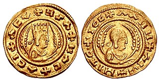
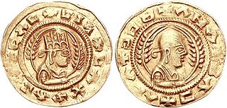
Ezana was ruler of the Kingdom of Aksum, an ancient kingdom located in what is now Eritrea and Ethiopia.. One of the best documented rulers of Aksum, Ezana is important as the first king of that country to embrace Christianity and to make it the official religion.

Qohaito was a major ancient city in what is now the Debub region of Eritrea. It was a pre-Aksumite settlement that thrived during the Aksumite period. The city was located over 2,500 meters above sea level, on a high plateau at the edge of the Great Rift Valley. As of 2011, Qohaito's stone ruins have yet to be excavated. The ancient port city of Adulis is directly to the east, while Matara lies to the south.

Hawulti is a pre-Aksumite obelisk located in Matara, Eritrea. The monument bears the oldest known example of the ancient Ge'ez script.

Metera or መጠራ (𐩣𐩷𐩧) is a small town and important archeological site located in the Debub Region of Eritrea. Situated a few kilometers south of Senafe (ሰንዓፈ), it was a major city in the Dʿmt (𐩵𐩲𐩣𐩩) and Aksumite kingdoms. Since Eritrean independence, the National Museum of Eritrea has petitioned the Ethiopian government to return artifacts removed from the site. However, the efforts have thus far been rebuffed.
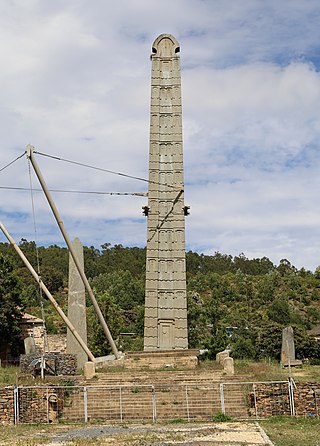
King Ezana's Stele is a 4th century obelisk in the ancient city of Axum, in the Tigray Region of Ethiopia. The monument stands in the middle of the Northern Stelae Park, which contains hundreds of smaller and less decorated stelae. This stele is probably the last one erected and the largest of those that remain unbroken. King Ezana of Axum's Stele stands 21 m (69 ft) tall, smaller than the collapsed 33 m (108 ft) Great Stele and the better-known 24 m (79 ft) "Obelisk of Axum". It is decorated with a false door at its base and apertures resembling windows on all sides.
Sembel, located in the capital of Asmara, Maekel Region of Eritrea, is East Africa's oldest archaeological site, dated back to as early as 800 BCE.
Eritrea, officially the State of Eritrea, is a country in the Horn of Africa region of Eastern Africa, with its capital and largest city at Asmara. It is bordered by Ethiopia in the south, Sudan in the west, and Djibouti in the southeast. The northeastern and eastern parts of Eritrea have an extensive coastline along the Red Sea. The nation has a total area of approximately 117,600 km2 (45,406 sq mi), and includes the Dahlak Archipelago and several of the Hanish Islands.
The Kingdom of Aksum, also known as the Kingdom of Axum, the City-State of Axum, or the Aksumite Empire, was centered in East Africa and South Arabia from Classical antiquity to the Middle Ages. Based primarily in what is now Eritrea and Northern Ethiopia, and spanning Djibouti and Sudan, it extended at its height into much of Southern Arabia during the reign of Kaleb, King of Axum.

Amud or Amoud is an ancient, ruined town in the Awdal region of Somaliland. Named after its patron Saint Amud it was a center of activity during the Golden Age of the Adal Kingdom. The archaeological site is situated 1,000 metres (3,300 ft) above sea level, around 10 km southeast of the regional capital Borama.

Tiya is an archaeological site in central Ethiopia. It is located in the Soddo woreda, in the Gurage Zone of the Southern Nations, Nationalities, and Peoples Region south of Addis Ababa. It is best known for its archaeological site its large stone pillars, many of which bear some form of decoration. The archeological site was designated a World Heritage Site in 1980, due to the unique nature of these monolithic monuments.
The Tigrinya people, also known as Tigrigna, are an ethnic group native to Eritrea. They speak the Tigrinya language. There also exists a sizable Tigrinya community in the diaspora.
References
- ↑ Asfawossen Asrat; Metasebia Demissie; Aberra Mogessie (2008). Geotourism in Ethiopia: Archaeological and Ancient Cities, Religious and Cultural Centres: Yeha, Azum, Wukru, and Lalibela. Shama Books. p. 67. ISBN 978-99944-0-030-0 . Retrieved 27 January 2018.
- ↑ French Centre for Ethiopian Studies (2009). Dossiers: un nouveau site pre-aksumite, Mäqabér Ga'éwa. Un territoire dans l'histoire, le Lasta. De Boccard. p. 53. ISBN 978-2-7018-0266-4 . Retrieved 27 January 2018.